Alincthun
- العربية
- Asturianu
- 閩南語 / Bân-lâm-gú
- Brezhoneg
- Català
- Cebuano
- Deutsch
- Eesti
- Español
- Euskara
- فارسی
- Français
- Bahasa Indonesia
- Italiano
- Қазақша
- Kurdî
- Latina
- Lëtzebuergesch
- Magyar
- Malagasy
- مصرى
- Bahasa Melayu
- Nederlands
- Нохчийн
- Occitan
- Picard
- Piemontèis
- Polski
- Português
- Română
- Shqip
- Simple English
- Slovenčina
- Српски / srpski
- Srpskohrvatski / српскохрватски
- Svenska
- Татарча / tatarça
- Türkçe
- Українська
- Vèneto
- Tiếng Việt
- Winaray
- Zazaki
- 中文
Tools
Actions
General
Print/export
Print/export
In other projects
Appearance
From Wikipedia, the free encyclopedia
This is an old revision of this page, as edited by InternetArchiveBot (talk | contribs) at 09:02, 17 January 2018 (Rescuing 1 sources and tagging 0 as dead. #IABot (v1.6.2) (Balon Greyjoy)). The present address (URL) is a permanent link to this revision, which may differ significantly from the current revision.
Revision as of 09:02, 17 January 2018 by InternetArchiveBot (talk | contribs) (Rescuing 1 sources and tagging 0 as dead. #IABot (v1.6.2) (Balon Greyjoy))
Commune in Hauts-de-France, France
Alincthun | |
|---|---|
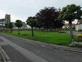
 The green in front of the church | |
| Coordinates: 50°43′55″N 1°48′07″E / 50.7319°N 1.8019°E / 50.7319; 1.8019 | |
| Country | France |
| Region | Hauts-de-France |
| Department | Pas-de-Calais |
| Arrondissement | Boulogne-sur-Mer |
| Canton | Desvres |
| Intercommunality | CC Desvres-Samer |
| Government | |
| • Mayor (2014-2020) | Jean Picque |
| Area 1 | 9.88 km2 (3.81 sq mi) |
| Population (2014) | 329 |
| • Density | 33/km2 (86/sq mi) |
| Time zone | UTC+01:00 (CET) |
| • Summer (DST) | UTC+02:00 (CEST) |
| INSEE/Postal code | 62022 /62142 |
| Elevation | 33–120 m (108–394 ft) (avg. 98 m or 322 ft) |
| 1 French Land Register data, which excludes lakes, ponds, glaciers > 1 km2 (0.386 sq mi or 247 acres) and river estuaries. | |
Alincthun is a commune in the Pas-de-Calais department in the Hauts-de-France region of France.
Geography
A small farming commune comprising 12 hamlets, some 10 miles (16 km) east of Boulogne, at the junction of the D238e2 and the D137 roads. The river Liane flows through the village.
Population
| Year | Pop. | ±% |
|---|---|---|
| 1962 | 304 | — |
| 1968 | 314 | +3.3% |
| 1975 | 309 | −1.6% |
| 1982 | 322 | +4.2% |
| 1990 | 364 | +13.0% |
| 1999 | 343 | −5.8% |
| 2009 | 344 | +0.3% |
Sights
- The church of St.Denis, dating from the seventeenth century.
- The seventeenth-century Château du Fresnoy.
- Three 17th-century manor houses at La Guilbauderie, Le Fay and Bois-du-Coq.
- A water mill.
See also
External links
Wikimedia Commons has media related to Alincthun.
This Pas-de-Calais geographical article is a stub. You can help Wikipedia by expanding it. |
Retrieved from "https://en.wikipedia.org/w/index.php?title=Alincthun&oldid=820907157"
Hidden categories:


