
Eynali
| Eynali | |
|---|---|
 | |
| Highest point | |
| Elevation | 1,800 m (5,900 ft)(Eynali peak) 2,378 m (7,802 ft) (Dand peak) |
| Coordinates | 38°06′20″N 46°19′20″E / 38.10556°N 46.32222°E |
| Geography | |
| Location | Tabriz, Iran |
| Geology | |
| Last eruption | Unknown |
| Climbing | |
| Easiest route | The pavement trail, 2 miles (3.3 km) to Eynali peak. |
Eynali is a mountain range in north of Tabriz, Iran. The range has a couple of peaks including Eynali (1800 m), Halileh (1850 m), Pakeh-chin (1945 m), Bahlul (1985 m) and the highest one Dand (2378 m).[1] It has red soil and it is seen from everywhere in Tabriz. There is a tomb at top of the mountain which is believed to be the grave of two clerics which the mountain's name is related to them. However some people believe that originally the building was a Zoroasterian temple and the shrine name to is a cover to saving the structure from destruction during Muslims invasion. Nowadays many residents of Tabriz used to hiking from base to the shrine as a daily sport activity. In early 2000s like many of other mountains in vicinity of big Iranian cities couple of unknown Iranian victims of Iran-Iraq war's are buried in top of the mountain behind the shrine as memories of the war. The mountain is also used by telecommunication companies and TV stations to rely their waves. Behind this the city council of Tabriz is trying to make an artificial forest at the hillsides of Eynali as northern green belt of Tabriz.
See also
Photo gallery
-
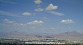 A view of Tabriz from southern hills of city where red mountain of Eynali is visible in background.
 -
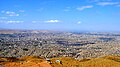 A view of Tabriz from Eynali foothills.
 -
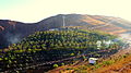 Artificial forest of Eynali.


External links
References


This East Azarbaijan province location article is a stub. You can help Wikipedia by expanding it. |