Fuzuli District
Appearance
Füzuli | |
|---|---|
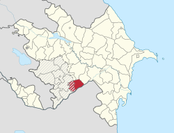
 Map of Azerbaijan showing Fuzuli Rayon | |
| Country | |
| Capital | Füzuli (De facto Horadiz due to Armenian occupation of Fuzuli) |
| Area | |
| • Total | 1,390 km2 (540 sq mi) |
| Population (1989[1] census) | |
| • Total | 89,417 |
| • Estimate (undated[2]) | 140,900 |
| Postal code | 1900 |
| Telephone code | (+994) 26[3] |
Fuzuli or Fizuli is a rayon of Azerbaijan. It was named after the Turkic poet Fuzûlî. Its capital is the town of Füzuli. The western half, including the capital, has been controlled by the breakway Nagorno-Karabakh, as part of its Hadrut Province, since the Nagorno-Karabakh War. Horadiz is temporarily center of Fuzuli Rayon due to Fuzuli's occupation by Armenians since 23 August 1993.
IDP's from Nagorno-Karabakh and the surrounding regions were moved to Fuzuli rayon from tent settlements around the country. The IDPs live in new houses built by the government.[4]
References
- ^ Official census in USSR, 1989
- ^ "Ministry of Culture and Tourism of Azerbaijan Republic. Fizuli". Retrieved April 28, 2010.
- ^ "Şəhərlərarası telefon kodları". Aztelekom MMC. Aztelekom İB. Retrieved 19 August 2015. Template:Az
- ^ "Azerbaijan: Life on the Frontlines". Eurasia.net. 2007-07-05. Retrieved 2010-10-07.

