
Getty Center Tram
| Getty Center Monorail (Getty Center Tram) | |
|---|---|
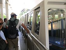
 A train at the Getty Center station | |
| Overview | |
| Locale | |
| Termini |
|
| Stations | 2 |
| Service | |
| Type | Otis Hovair hovertrain |
| Rolling stock | 6 cars |
| History | |
| Opened | 1997 |
| Technical | |
| Line length | 1.21 km (0.75 mi)[1] |
| Number of tracks | 1 (Monorail) |
The Getty Center Monorail, also known as Getty Center Tram, is an Otis Hovair monorail of the U.S. city of Los Angeles serving the Getty Center. It is an electric, cable-driven hovertrain, with a fleet of 6 people movers divided in 2 convoys of 3 cars each.[1]
History
The railway line, already planned in 1988,[2] was opened at the end of 1997, following the inauguration of "The Getty".
Route
The line, located north of Brentwood, in the Westside Region of Los Angeles, links a freeway-level parking garage to the Getty Center, a campus of the Getty Museum, that is 1.21 km (0.75 mi) far. The duration of a ride is about 3/4 minutes.[1]
The lower station (34°05′15.8″N 118°28′32.8″W / 34.087722°N 118.475778°W), at the bottom of the hill, lies beside Sepulveda Boulevard and the San Diego Freeway. The upper station (34°04′42.1″N 118°28′29.9″W / 34.078361°N 118.474972°W), at the top of the hill, is located in the arrival plaza of "The Getty" and is part of the structure.[3] The line, that follows the "Getty Center Drive", has a passing siding in the middle.
Gallery
-
 View of the upper station
 -
 The platform of the lower station
 -
 A train departing from the lower station

.jpg)

See also
References
- ^ a b c The Getty Center Tram on waymarking.com
- ^ "Tram System Proposed for J. Paul Getty Center". Los Angeles Times, July 14, 1988
- ^ 24563086 Getty Center Tram on OpenStreetMap
