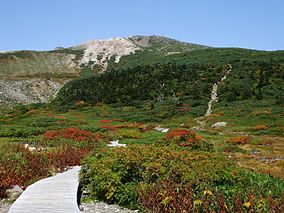
Hakusan National Park
| Hakusan National Park | |
|---|---|
| 白山国立公園 | |
 | |
 | |
| Location | Chūbu region, Honshū, Japan |
| Coordinates | 36°09′18″N 136°47′17″E / 36.15500°N 136.78806°E |
| Area | 477 km2 (184 sq mi) |
| Established | 12 November 1962 |
Hakusan National Park (白山国立公園, Hakusan Kokuritsu Kōen) is a national park in the Chūbu region of Honshū, Japan. Established in 1962, it spans the borders of Fukui, Gifu, Ishikawa, and Toyama prefectures. Its main geographical feature is Mount Haku. In 1980 an area of 480 km² corresponding to the national park was designated a UNESCO Man and the Biosphere Reserve.[1][2]
History
The park was originally designated Hakusan Quasi-National Park (白山国定公園, Hakusan Kokutei Kōen), in 1955. It received full national park status in 1962.[3]
Flora and fauna
The vegetation of the park ranges from warm temperate to alpine zones. The base of the mountains is covered by coniferous forests, dominated by firs, pines (Pinus aristata) and Japanese cedar. Deciduous forests and woodlands, dominated by Mongolian oak and Japanese beech are present. At higher elevations there are open landscapes.
Hakusan is home to the golden eagle, the mountain hawk-eagle and several larger mammal species typical for the Japanese islands, like Japanese macaque, Asiatic black bear, Japanese serow and Sika deer.[1]
Sites of interest
Mount Akausagi (赤兎山), Mount Haku, Heisen-ji Hakusan Jinja (平泉寺白山神社), Hyakuyojō falls (百四丈滝), Kyō Mountains (経ヶ岳), Shiramizu falls (白水滝)[4][5]
Neighboring municipalities
See also
References
- ^ a b "Hakusan National Park". Natural Parks Foundations. Retrieved 4 February 2012.
- ^ "Hakusan MAB Reserve". UNESCO. Retrieved 4 February 2012.
- ^ "Hakusan National Park". Ishikawa Prefecture. Retrieved 4 February 2012.
- ^ "Hakusan National Park". Fukui Prefecture. Retrieved 4 February 2012.
- ^ "Hakusan National Park". Gifu Prefecture. Retrieved 4 February 2012.
- ^ "Hakusan National Park - Basic Information". Ministry of the Environment. Retrieved 4 February 2012.

