
Haute-Saône
Haute-Saône | |
|---|---|
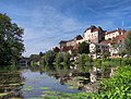
 The Saône river near bucey les traves | |
 Coat of arms | |
 Location of Haute-Saône in France | |
| Coordinates: 47°35′N 06°00′E / 47.583°N 6.000°E | |
| Country | France |
| Region | Bourgogne-Franche-Comté |
| Prefecture | Vesoul |
| Subprefectures | Lure |
| Government | |
| • President of the General Council | Yves Krattinger |
| Area | |
| • Total | 5,360 km2 (2,070 sq mi) |
| Population (2016) | |
| • Total | 237,242 |
| • Rank | 83rd |
| • Density | 44/km2 (110/sq mi) |
| Time zone | UTC+1 (CET) |
| • Summer (DST) | UTC+2 (CEST) |
| Department number | 70 |
| Arrondissements | 2 |
| Cantons | 17 |
| Communes | 539 |
| ^1 French Land Register data, which exclude estuaries, and lakes, ponds, and glaciers larger than 1 km2 | |
Haute-Saône (French pronunciation: [ot.soːn]; Arpitan: Hiôta-Sona) is a French department of the Bourgogne-Franche-Comté region named after the Saône River.
Administration
Haute-Saône is divided into 2 arrondissements and 17 cantons.
History
The department was created in the early years of the French Revolution through the application of a law dated 22 December 1789, from part of the former province of Franche-Comté. The frontiers of the new department corresponded approximately to those of the old Bailiwick of Amont.
Geography
Haute-Saône is part of the Bourgogne-Franche-Comté region. Neighbouring departments are Côte-d'Or to the west, Haute-Marne to the north-west, Vosges to the north, Territoire de Belfort to the east, Doubs to the south and east and Jura to south.
The department can be presented as a transitional territory positioned between several of the more depressed departments of eastern France and the so-called Blue Banana zone characterised, in recent decades by relatively powerful economic growth.
Economy
The department is overwhelmingly rural, despite the area having been at the forefront of industrialisation in the eighteenth century. The industrial tradition endures, but industrial businesses tend to be on a small scale. In 2006 employment by economic sector was reported as follows:[1]
- * Agriculture 4,919 employees
- * Construction 4,504 employees
- * Industrial sector 18,747 employees
- * Service sector 44,865 employees
Demographics

In common with many rural departments in France, Haute-Saône has experienced a savage reduction in population, from nearly 350,000 in the middle of the nineteenth century to barely 200,000 on the eve of the Second World War, as people migrated to newly industrialising population centres, often outside Metropolitan France.
During the second half of the twentieth century the mass mobility conferred by the surge in automobile ownership permitted some recovery of the population figure to approximately 234,000 in 2004.
The rural nature of the department is highlighted by the absence of large towns and cities. Even the department's capital, Vesoul, still had a population below 20,000 in 2010.
Politics
Current National Assembly Representatives
| Constituency | Member[2] | Party | |
|---|---|---|---|
| style="background-color: Template:La République En Marche!/meta/color" | | Haute-Saône's 1st constituency | Barbara Bessot Ballot | La République En Marche! |
| style="background-color: Template:La République En Marche!/meta/color" | | Haute-Saône's 2nd constituency | Christophe Lejeune | La République En Marche! |
Tourism
-
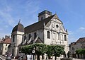 Church in Vesoul
 -
 Renaissance townhall of Gray
 -
-


See also
- County of Burgundy - History
- Franche-Comté
- Cantons of the Haute-Saône department
- Communes of the Haute-Saône department
- Arrondissements of the Haute-Saône department
- Arpitan language
References
External links
- Template:Fr icon Prefecture website
- Template:Fr icon General Council website
- Template:Fr icon Tourism website
| International | |
|---|---|
| National | |
| Geographic | |
| Other | |