
Mount Abu
Mount Abu
माउंट आबू Abu Parvat | |
|---|---|
 | |
 Mount Abu  Mount Abu | |
| Coordinates: 24°35′33″N 72°42′30″E / 24.5925°N 72.7083°E | |
| Country | India |
| State | Rajasthan |
| District | Sirohi |
| Government | |
| • Type | Tourist |
| Elevation | 1,220 m (4,000 ft) |
| Population (2011)[1] | |
| • Total | 22,943 |
| • Density | 50/km2 (100/sq mi) |
| Time zone | UTC+5:30 (IST) |
| PIN | 307501 |
| Telephone code | +02974 |
| ISO 3166 code | RJ-IN |
| Vehicle registration | RJ 38 |
| Website | www.mountabu.net.in |
Mount Abu (ⓘ) is a popular hill station in the Aravalli Range in Sirohi district of Rajasthan state in western India, near the border with Gujarat. The mountain forms a distinct rocky plateau 22 km long by 9 km wide. The highest peak on the mountain is Guru Shikhar at 1,722 m (5,650 ft) above sea level. It is referred to as 'an oasis in the desert' as its heights are home to rivers, lakes, waterfalls and evergreen forests. The nearest train station is Abu Road railway station: 28 km away.[2]
History
The ancient name of Mount Abu is Arbudaanchal. In the Puranas, the region has been referred to as Arbudaranya ("forest of Arbhuda") and 'Abu' is a diminutive of this ancient name. It is believed that sage Vashistha retired to the southern spur at Mount Abu following his differences with sage Vishvamitra. There is another mythology according to which a serpent named "Arbuda" saved the life of Nandi (Lord Shiva's bull). The incident happened on the mountain that is currently known as Mount Abu and so the mountain is named "Arbudaranya" after that incident which gradually became Abu.
The conquest of Mount Abu in 1311 CE by Rao Lumba of Deora-Chauhan dynasty brought to an end the reign of the Parmars and marked the decline of Mount Abu. He shifted the capital city to Chandravati in the plains. After the destruction of Chandravati in 1405, Rao Shasmal made Sirohi his headquarters. Later it was leased by the British government from the then Maharaja of Sirohi for use as the headquarters.
Mount Abu and Gurjars
The Arbuda Mountains (Abu Parvat ' Mount Abu) region is said to be original abode of the famous Gurjars. The association of the Gurjars with the mountain is noticed in many inscriptions and epigraphs including Tilakamanjari of Dhanpala.[3] These Gurjars (Gujars or Gujjars) migrated from the Arbuda mountain region. As early as sixth century CE, they set up one or more principalities in Rajasthan and Gujarat. Almost all or a larger part of Rajasthan and Gujarat had been known as Gurjaratra (country ruled or protected by the Gurjars) or Gurjarabhumi (land of the Gurjars) for centuries before the Mughal period.[4]
Mount Abu and Rajputs
According to a legend, sage Vashistha performed a great yajna at the peak of Mount Abu, to seek from the gods a provision for the defense of righteousness on earth. In answer to his prayer, a youth arose from the Agnikunda (fire-altar) — the first Agnivansha Rajput.[5][6]
Tourism


Mount Abu town, the only hill station in Rajasthan, is at an elevation of 1,220 m (4,003 ft). It has been a popular retreat from the heat of Rajasthan and neighbouring Gujarat for centuries. The Mount Abu Wildlife Sanctuary was established in 1960 and covers 290 km² of the mountain.
The mountain is home to several Hindu temples, including the Adhar Devi Temple (also known as Arbuda Devi Temple), carved out of solid rock; the Shri Raghunathji Temple; and a shrine and temple to Dattatreya built atop the Guru Shikhar peak and a number of Jain temples including Dilwara Temples, a complex of temples carved of white marble built between the 11th and 13th centuries CE. The oldest of these is the Vimal Vasahi temple, built in 1021 CE by Vimal Shah and dedicated to the first of the Jain Tirthankaras. They include the Achaleswar Mahadev Temple (1412) and the Kantinath Temple (1513). It is the location of the headquarters of the Brahma Kumaris.
The Achalgarh Fort, built in the 14th century by Kumbha of Mewar, is nearby and at its center is the popular visitor attraction of the Nakki Lake. The Toad Rock is on a hill near the lake. Close to the fort is the Achaleshwar Mahadev Temple, a popular Shiva temple.
The Durga Ambika Mata Temple lies in a cleft of rock in Jagat, just outside Mount Abu town.
In Mount Abu, the faith community of Brahma Kumaris has its spiritual headquarters, which are represented by its own account in 110 countries.[7] Every year about 2.5 million visitors are supposed to visit the sprawling campus of that spiritual movement.[8]
While there are hundreds of hotels for tourists, some Dharamshalas can be found for as low as Rs.700 per night. Raghunath Dharamshala at the bank of Nakki Lake is one of those in a spiritual environment.
In summer thousands of people come here. To reach Mount Abu, the nearest approach by road is from Abu Road which is 27 kms.
The setting sun scene on Mt Abu is famous among tourist; it was depicted in the movie Qayamat Se Qayamat Tak.[citation needed]
Climate
Summer
Summer prevails from mid-April to mid-June, when the average maximum temperature remains around 36 °C. It is suited for light cotton clothes.
Monsoon
Due to its relief and geographical conditions, it rains in Mount Abu during the monsoons. During the rainy season the temperature falls. Normal summer clothing works. It is wise to carry an umbrella to avoid being caught in the rain.
Winter
Winters are cool in Mount Abu, with mercury hovering around 16 °C to 22 °C. Nights are chilly, and the average night temperature is around 4 to 12 °C. The temperature has dipped to as low as −2 to −3 °C. Heavy winter clothing is preferable. In daytime, light pullovers are sufficient.
| Climate data for Mount Abu | |||||||||||||
|---|---|---|---|---|---|---|---|---|---|---|---|---|---|
| Month | Jan | Feb | Mar | Apr | May | Jun | Jul | Aug | Sep | Oct | Nov | Dec | Year |
| Mean daily maximum °C (°F) | 17.3 (63.1) |
20.4 (68.7) |
24.3 (75.7) |
29.4 (84.9) |
31.5 (88.7) |
29.1 (84.4) |
24.5 (76.1) |
22.7 (72.9) |
24.5 (76.1) |
26.7 (80.1) |
23.8 (74.8) |
19.2 (66.6) |
24.5 (76.0) |
| Mean daily minimum °C (°F) | 4.5 (40.1) |
6.8 (44.2) |
11.1 (52.0) |
18.7 (65.7) |
21.0 (69.8) |
19.8 (67.6) |
18.7 (65.7) |
17.8 (64.0) |
17.6 (63.7) |
15.8 (60.4) |
9.3 (48.7) |
5.1 (41.2) |
13.9 (56.9) |
| Average precipitation mm (inches) | 5.3 (0.21) |
4.4 (0.17) |
6.5 (0.26) |
2.6 (0.10) |
16.4 (0.65) |
101.6 (4.00) |
573.2 (22.57) |
600.3 (23.63) |
214.2 (8.43) |
19.4 (0.76) |
7.9 (0.31) |
2.4 (0.09) |
1,554.2 (61.18) |
| Source: [9] | |||||||||||||
Demographics
According to the 2011 Census of India, Mount Abu has a population of 22,943 out of which 54.7% are males and 45.3% are females. It has an average literacy rate of 81.15%, higher than the national average of 74.04%: male literacy is 90.12%, and female literacy is 70.23%. In Mount Abu, 12.34% of the population is under 6 years of age.[10]
89.31% of people are Hindus, 7.69% are Muslims while 1.45% are Christians.[10]
Gallery
-
 Parshvanatha Temple at Dilwara group of temples
 -
 Marble sculpture of Dilwara Temples
 -
 Kalpavriksha or Kalpavruksha page in Dilwada Jain Temple
 -
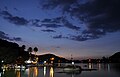 Nakki Lake after sunset
 -
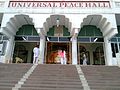 Brahma Kumari foundation headquarters at Mount Abu
 -
 Mount Abu Wildlife Sanctuary covers 290 km² of mountains, forests and lake.
 -
 Turtle shaped rock near the Nakki Lake.
 -
 Toad rock on a hill near the Nakki Lake.


.jpg)
References
- ^ "Census of India Search details". censusindia.gov.in. Retrieved 10 May 2015.
- ^ Agarwal, Deepesh. "How to reach Mount Abu by Road, Air Or Rail". www.mountabu.com. Retrieved 2017-06-22.
- ^ Sudarśana Śarmā (2002). Tilakamañjarī of Dhanapāla: a critical and cultural study. Parimal Publications. p. 214.
- ^ Ramesh Chandra Majumdar; Achut Dattatrya Pusalker; A. K. Majumdar; Dilip Kumar Ghose; Vishvanath Govind Dighe; Bharatiya Vidya Bhavan (1977). The History and Culture of the Indian People: The classical age. Bharatiya Vidya Bhavan. p. 153.
- ^ Barua, Pradeep (2005). The State at War in South Asia. University of Nebraska Press. p. 24. ISBN 9780803213449.
- ^ https://books.google.com/books?id=K7ZZzk8cXh8C&pg=PA6&dq=rajputs+origin+fire++mount+abu&hl=en&sa=X&ei=_SJnVM2aBcGeugSk44C4Bw&ved=0CFcQ6AEwCQ#v=onepage&q&f=false
- ^ "Official Website of the Brahma Kumaris". Retrieved 2013-11-20.
- ^ "Official Website of the Brahma Kumaris, Spiritual Headquarters: Mount Abu". Retrieved 2013-11-20.
- ^ [www.imd.gov.in/section/climate/climateimp.pdf]
- ^ a b "Mount Abu City Population Census 2011 - Rajasthan". www.census2011.co.in. Retrieved 2017-06-22.
External links
- Shri Achaleshwar Mahadev Mandir
- Mount Abu Coordinates
- Mount Abu Population
- Abu Winter Festival
- Mount Abu Virtual Tour 360
- Mount Abu Panorama
- . Collier's New Encyclopedia. 1921.

| International | |
|---|---|
| National | |