Sea Gate, Brooklyn


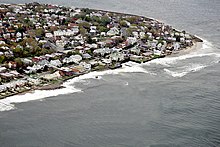
Sea Gate is a private gated community at the far western end of Coney Island at the southwestern tip of the New York City borough of Brooklyn.[1] It contains mostly single-family homes, some directly on Gravesend Bay.
History
The area that is now Sea Gate was once known as Norton's Point.[1] "Norton" was the name of the owner of a casino, which was situated where the Coney Island Light now stands.[1] The neighborhood held a reputation for gambling before it was developed into a residential neighborhood.[1]
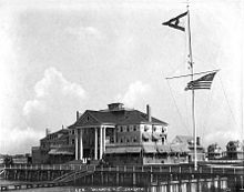
Sea Gate was developed into a full neighborhood in 1892 by developer Alrick Man.[1] By 1899, Sea Gate property owners included the Morgan, Dodge family, and Vanderbilt families. Governor Al Smith and others frequented the Atlantic Yacht Club, whose clubhouse was designed by Stanford White.[citation needed]
Sea Gate is still surrounded on three sides by water with private beaches. In 1995, the Army Corps of Engineers completed its work of replenishing Coney beaches and building new jetties, including a long jetty at the border of Sea Gate and Coney Island.[citation needed]
In October 2012, Hurricane Sandy devastated Sea Gate. The neighborhood was inundated by ocean water and battered by strong winds. The area sustained significant damage and numerous houses were destroyed.[2] The "Lindy Park" sea wall/ bulkhead (officially known as Beach Reservation extending from Beach 48th Street to Beach 50th Street) was destroyed leaving Sea Gate, Coney Island and beyond open to any rough seas and additional damage.
Description
Residents refer to Sea Gate as "the gate" and venturing into adjoining Coney Island as going "out the gate". There are no stores in the neighborhood. There are express buses to Manhattan, which take an average of 80 minutes.[1] As of 2010[update] Sea Gate is made up of 832 single-family houses in a variety of architectural styles, including Queen Anne Style and Mediterranean.[1]
Residents pay for Sea Gate Police, sewer, beach, lifeguards, street lights, and street cleaning.[3]
There are two landmarks in Sea Gate. Located on Beach 47th Street in Sea Gate is the 75-foot-tall (23 m) Coney Island Light, is a lighthouse built in 1890, before the area was populated. The lighthouse is the former home of Frank Schubert, the United States' last civilian lighthouse keeper, who died in 2003.[1] Also, the chapel in Sea Gate, once used for services and built in 1901, is a historical building now used for social events, yoga classes, and is a polling site at election times. The Chapel with its stained-glass windows is the first structure seen when entering the main (police protected) gate.[1]
In addition to large and private beach areas, Sea Gate has two parks:
- A playground with a basketball court and children's jungle gym pieces next to the Sea Gate Community Center on Surf Avenue.
- Beach Reservation (as referred to on the map of Sea Gate, VI.a, 1894) is near the Coney Island Light and extends before and beyond Norton's Point. A sandy/grassy patch of land with views of Lower New York Harbor and the Verrazano-Narrows Bridge. It is nicknamed "Lindy Park", commemorating Charles Lindbergh. The "Lindy Park" sea wall was painted for the celebration of the United States Bicentennial in 1976; it read, "SEA GATE USA--WELCOME WORLD".
In the summer, residents, or "Sea Gaters", sometimes walk on the streets in only bathing suits. Children play in the streets until well after sundown; vehicular traffic is relatively sparse on many streets. Many visit the amusement area and boardwalk of adjacent Coney Island.There are often fireworks on Friday nights. Fishing is available for several seasonal species, including fluke (summer flounder), porgies, blackfish, flounder and even small striped bass. Sometimes there are also snapper blues, pilotfish, blowfish and eels. The Sea Gate beach is private and residents pay to maintain it. Residents pay the salaries of Lifeguards. Residents pay ( in addition) for a Beach Pass and visitors must show beach passes as well. It is uncrowded and patrolled by lifeguards in season. Beach access is also offered to members of the Sea Gate Beach Club. The beach club, originally for residents, is now privately run and open to anyone who pays for membership. It adjoins the hub of Sea Gate summer life, the Riviera or the "Riv," with its handball and basketball courts, benches for card playing, restaurant/café, and a jukebox, spinning discs into the evening.
Education
The New York City Department of Education operates public schools that serve Sea Gate.
Demographics
Sea Gate is largely populated by families living in single- and two-family houses, 54% being rentals. As of 2000, the median age was 38.6 years and the median household income was $41,659.[4] In addition to city and state taxes, residents pay dues and charges to the Sea Gate Association.
Notable residents
- Leonard Everett Fisher, writer (The Jetty Chronicles)
- Jack Foley, the inventor of movie sound effects
- Yossi Green, Jewish music composer[5]
- Herbie Kronowitz, middleweight contender in the 1940s
- George Reeves, portrayed Superman on television, rumored to have lived there one summer
- Ludwig Satz, an actor in Yiddish theater and film, best known for his comic roles. A 1925 New York Times article singles him out as the greatest Yiddish comic actor of the time.
- Beverly Sills, opera singer
- Isaac Bashevis Singer, Yiddish author
- Irwin Winkler, film producer and director, won an Oscar for Best Picture for "Rocky"
- Mordechai Ben David and his son Yeedle, singers[5]
References
- ^ a b c d e f g h i Hughes, C.J. (2010-09-03). "Living In Sea Gate, Brooklyn". New York Times. Retrieved 2010-09-05.
- ^ http://www.oregonlive.com/today/index.ssf/2012/10/superstorm_sandy_residents_sur.html Superstorm Sandy: Residents survey damage in New York's famed Coney Island
- ^ "Sea Gate PD: An Integral Element of New York's First Gated Community". Without a Badge. Retrieved 2015-09-16.
- ^ Broker Website for Sea Gate, Brooklyn
- ^ a b Teitelbaum, C. S. "Songs for the Soul: The man behind 'Neshama Flam'", Hamodia Magazine, June 16, 2011, pg. 18.


