Taston
| Taston | |
|---|---|
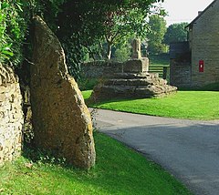
 Thor Stone (left foreground), with the Medieval preaching cross beyond | |
Location within Oxfordshire | |
| OS grid reference | SP3621 |
| Civil parish | |
| District | |
| Shire county | |
| Region | |
| Country | England |
| Sovereign state | United Kingdom |
| Post town | Chipping Norton |
| Postcode district | OX7 |
| Dialling code | 01608 |
| Police | Thames Valley |
| Fire | Oxfordshire |
| Ambulance | South Central |
| UK Parliament | |
| Website | Spelsbury Parish Council |
Taston is a hamlet in Spelsbury civil parish, about 1.6 miles (2.6 km) north of Charlbury and 4 miles (6.4 km) southeast of Chipping Norton, Oxfordshire.
History
Its toponym is derived from Thorstan meaning "Thorstone", a small standing stone claimed to be a thunderbolt of the god Thunor.[1]
At the centre of Taston are the base and broken shaft of a Medieval preaching cross.[2] It is a Grade II* listed building.[3]
Middle Farmhouse is a house built of coursed rubble in the 17th and early 18th centuries.[4] Part of the roof is of Stonesfield slate.[4] The farmstead has a four-bay barn that was built of stone early in the 18th century and altered in 1884.[5]
The Firkins is a small house near Thorsbrook Spring. It is built of rubble and probably dates from early in the 18th century.[6]
At Thorsbrook Spring, about 140 yards (130 m) southeast of the preaching cross, is a Victorian Gothic Revival memorial fountain. It was built in 1862 in memory of Henrietta, Viscountess Dillon,[7] wife of Henry Dillon, 13th Viscount Dillon.
References

- ^ faerygirl (6 January 2011). "Thor Stone; Standing Stone / Menhir". The Modern Antiquarian. Julian Cope. Retrieved 26 April 2011.
- ^ Sherwood, Jennifer; Pevsner, Nikolaus (1974). Oxfordshire. The Buildings of England. Harmondsworth: Penguin Books. p. 776. ISBN 0 14 071045 0.
- ^ Historic England. "Cross (1251432)". National Heritage List for England. Retrieved 27 February 2012.
- ^ a b Historic England. "Middle Farmhouse (1262715)". National Heritage List for England. Retrieved 27 February 2012.
- ^ Historic England. "Barn Approximately 15 Metres South East of Middle Farmhouse (1251433)". National Heritage List for England. Retrieved 27 February 2012.
- ^ Historic England. "The Firkins (1262714)". National Heritage List for England. Retrieved 27 February 2012.
- ^ Historic England. "Memorial Fountain (1262769)". National Heritage List for England. Retrieved 27 February 2012.
External links

- Map sources for Taston


