
Tornio
Template:Infobox Finnish municipality
Tornio (official name: Tornion kaupunki; in Template:Lang-se; in Swedish: Torneå) is a city and municipality in Lapland, Finland. The city forms a cross-border twin city together with Haparanda on the Swedish side. The municipality covers an area of [convert: invalid number], of which [convert: invalid number] is water.[1] The population density is [convert: invalid number], with a total population of Template:Infobox Finnish Municipality/population count (Error: Invalid time.).[2] It borders the Swedish municipality of Haparanda (in Finnish: Haaparanta). In spite of being a border city Tornio is unilingually Finnish with a negligible number of Swedish speakers.
History
The delta of the Torne river has been inhabited since the end of the last ice age, and there are currently (1995) 16 settlement sites (boplatsvallar) known in the area, similar to those found in Vuollerim (c. 6000–5000 BC). The Swedish part of the region is not far from the oldest permanent settlement site found in Scandinavia.[3] A former hypothesis that this region was uninhabited and "colonised" from the Viking Age onward has now been abandoned.
The church spire at Tornio was one of the landmarks used by de Maupertuis in his measurements. The church was constructed in 1686 by Matti Joosepinpoika Härmä.
Until the 19th century, inhabitants of the surrounding countryside spoke Finnish, and Kemi Sami, a language of the Eastern Sami group similar to Finnish, while those of the town were mainly Swedish-speaking.
The name 'Tornio' is an old Finnish word meaning war spear: the city is named after the river.[4] To Swedish it was borrowed as Torneå after Torne å, an alternative name of the river.
The town received its charter from the King of Sweden in 1621 and was officially founded on the island of Suensaari (possibly named after one of the main landowners of the past). The charter was granted in recognition of Tornio being the hub of all trade in Lapland throughout the 16th century. It was the largest merchant town in the North at the time and for some years ranked as the richest town in the Swedish realm. Despite the lively trade with Lapland and overseas, the population of the town remained stable for hundreds of years at little over 500.
During the 18th century Tornio was visited by several expeditions from Central Europe which came to explore the Arctic. The most notable expedition (1736–1737) was led by a member of the Académie française, Pierre Louis Moreau de Maupertuis, who came to take meridian arc measurements along the Meänmaa which would show that the globe is flattened towards the poles.
The Lapland trade on which Tornio depended started to decline in the 18th century, and the harbour had to be moved downriver twice as a result of the rising of the land (post-glacial rebound), which made the river too shallow for navigation. However, the greatest blow to the wealth of the town came in the last war between Sweden and Russia in 1808, which saw the Russians capture and annexe Finland. The border was drawn through the deepest channel of the Muonio and Tornio rivers, splitting Lapland into two parts, with deleterious effects on trade. Tornio ended up on the Russian side of the border by special request of the Russian czar. The Swedes developed the village of Haaparanta (present day Haparanda) on their side of the border, to balance the loss of Tornio, and Tornio became unilingually Finnish.
During the Russian period Tornio was a sleepy garrison town. Trade only livened up during the Crimean War and the First World War, when Tornio became an important border crossing for goods and people. During the First World War Tornio and Haparanda had the only rail link connecting the Russians to their Western allies.
After the independence of Finland in 1917 Tornio lost its garrison and experienced further decline. although its population increased steadily. The town played no role of importance in the Finnish Civil War, but was the scene of some fierce street fighting at the onset of the Lapland War between Finland and Nazi Germany. The rapid liberation of the town by Finnish forces probably saved it from being burned down like so many other towns in Lapland. As a result, the beautiful wooden church from 1686 can still be admired today.
After World War II, the town created new employment built on the success of the local Lapin Kulta brewery and the Outokumpu stainless steel mill. Tourism based on the border has also been a growing industry. The town is a centre of education for Western Lapland with a vocational college and a university of applied sciences.
Tornio and Haparanda have a history as twin cities, and are currently set to merge under the names TornioHaparanda and HaparandaTornio. A new city centre is under construction on the international border and several municipal services are shared.[5] The towns alo share a common golf course, situated astride the border. The new IKEA store in Haparanda has signposting in Finnish as well as in Swedish, and all prices are signposted in two currencies.
Sports
Tornion Palloveikot, or just ToPV, is a bandy club which play in the Bandyliiga and has become Finnish bandy champions several times. They play their home matches in Haparanda, just on the other side of the Swedish border, which was the venue for games at the 2001 Bandy World Championship.
Teemu Tainio, footballer, was born in Tornio.
Climate
Tornio has a subarctic climate that is slightly tempered in winter by its proximity to the sea, but retains warm continental summers that are quite short. The weatherbox is from neighbouring city Haparanda and operated by Swedish Meteorological and Hydrological Institute.
| Climate data for Haparanda (adjacent to Tornio), 2002-2015; precipitation 1971-2000; extremes since 1901 | |||||||||||||
|---|---|---|---|---|---|---|---|---|---|---|---|---|---|
| Month | Jan | Feb | Mar | Apr | May | Jun | Jul | Aug | Sep | Oct | Nov | Dec | Year |
| Record high °C (°F) | 8.4 (47.1) |
7.8 (46.0) |
10.3 (50.5) |
18.5 (65.3) |
28.8 (83.8) |
31.4 (88.5) |
32.5 (90.5) |
29.7 (85.5) |
24.0 (75.2) |
17.0 (62.6) |
11.5 (52.7) |
7.0 (44.6) |
32.5 (90.5) |
| Mean daily maximum °C (°F) | −5.9 (21.4) |
−5.5 (22.1) |
−0.5 (31.1) |
5.3 (41.5) |
12.3 (54.1) |
17.6 (63.7) |
20.8 (69.4) |
18.9 (66.0) |
13.2 (55.8) |
5.5 (41.9) |
0.2 (32.4) |
−2.7 (27.1) |
6.6 (43.9) |
| Daily mean °C (°F) | −9.2 (15.4) |
−10.3 (13.5) |
−5.1 (22.8) |
1.1 (34.0) |
7.5 (45.5) |
13.0 (55.4) |
16.4 (61.5) |
14.6 (58.3) |
9.3 (48.7) |
2.5 (36.5) |
−2.7 (27.1) |
−6.0 (21.2) |
2.5 (36.5) |
| Mean daily minimum °C (°F) | −13.3 (8.1) |
−13.5 (7.7) |
−9.7 (14.5) |
3.0 (37.4) |
2.7 (36.9) |
8.2 (46.8) |
12.0 (53.6) |
10.2 (50.4) |
5.4 (41.7) |
−0.5 (31.1) |
−5.2 (22.6) |
−9.4 (15.1) |
−0.8 (30.6) |
| Record low °C (°F) | −40.8 (−41.4) |
−41.7 (−43.1) |
−37.5 (−35.5) |
−26.0 (−14.8) |
−10.5 (13.1) |
−1.5 (29.3) |
2.2 (36.0) |
−1.8 (28.8) |
−8.1 (17.4) |
−23.0 (−9.4) |
−32.3 (−26.1) |
−37.3 (−35.1) |
−41.7 (−43.1) |
| Average precipitation mm (inches) | 47.2 (1.86) |
36.7 (1.44) |
38.2 (1.50) |
31.0 (1.22) |
34.6 (1.36) |
43.2 (1.70) |
56.8 (2.24) |
67.0 (2.64) |
62.6 (2.46) |
63.7 (2.51) |
61.6 (2.43) |
47.5 (1.87) |
590.1 (23.23) |
| Source 1: [6] | |||||||||||||
| Source 2: [7] | |||||||||||||
Transport

A break of gauge occurs at Tornio between the Finnish and Swedish railway systems. A bogie exchange and variable gauge axle track gauge changing facility are provided.
Kemi-Tornio Airport is located in Kemi, about 18 kilometres (11 mi) south-east from Tornio city centre.
Highway 29 (part of the European route E8) between Keminmaa and Tornio is the world's northernmost motorway. Tornio is also the northern terminus of European Route E4.
Twin cities

Tornio's closest economic and cultural ties are with its immediate neighbour:
 Haparanda, Sweden
Tornio also has links with:
 Devizes, England
 Hammerfest, Norway
 Ikast, Denmark
 Kirovsk, Russia
 Szekszárd, Hungary
- Vetlanda, Sweden
Notable individuals
- Aarne Heikinheimo, Jäger Major-General
- Antti Ekman, Bandy player
- Einar Reuter, writer, art critic and painter
- Heikki Hyvönen, bandy player
- Heikki Niva, gymnast
- Hemming Åström, businessman
- Henri Sillanpää, footballer
- Ivar Lantto, politician
- Jarl Sundqvist, forester and long-term director of the Forestry Department in Lapland
- Jesse Puljujärvi, ice hockey player
- Joni Myllykoski, ice hockey player
- Juho-Teppo Berg, footballer
- Jukka Isometsä, ice hockey league judge
- Jussi Hakasalo, footballer
- Jussi Kanervo, athletics competitor
- Kai Sadinmaa, clergyman and writer
- Kalle Palander, alpine skier
- Kari Savio, writer
- Leena Huhta, sprinter
- Läjä Äijälä, musician
- Marko Herajärvi
- Mauno Saari, journalist, writer and screenwriter
- Paavo Ottelin, Jäger lieutenant
- Pasi Hiekkanen, football goalkeeper and bandy player
- Risto Mäkitalo, architect
- Saku Mäenalanen, ice hockey player
- Sari Eero, athlete
- Seppo Kanerva, politician
- Teemu Tainio, footballer
- Tuuli Matinsalo, aerobics athlete
- Ville Pokka, ice hockey player
- Vuokko Mattila, hairdresser
- Mira Sunnari, musician
See also
- Haparanda (Sweden)
- Övertorneå (Sweden)
Gallery

-
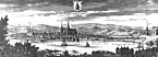 Engraving from the period of Swedish administration
 -
 A postcard view of Tornio by Alex Federley (1908)
 -
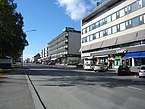 Central Tornio.
 -
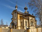 Orthodox Church, Tornio
 -
 Postage stamp, Finland, 1971
 -
 Porthan's School, in the Suensaari district of Tornio, Finland, dating from 1910.
 -
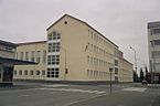 Suensaari School, constructed in the early 1900s originally a Russian barracks.


References
- ^ Cite error: The named reference
total_areawas invoked but never defined (see the help page). - ^ Cite error: The named reference
population_countwas invoked but never defined (see the help page). - ^ as currently known in 2004.
- ^ Vahtola, Jouko (1980). Studia Historica Sptentrionalia 3 (in Finnish). Rovaniemi. pp. 102–107. ISBN 951-95472-1-5.
{{cite book}}: CS1 maint: location missing publisher (link) - ^ Rajalla – På Gränsen Archived June 28, 2007, at the Wayback Machine
- ^ "SMHI".
{{cite web}}: Cite has empty unknown parameter:|(empty string)=(help) - ^ "SMHI Average Monthly Data 2002-2015".
External links
- Town of Tornio – Official website
 Tornio travel guide from Wikivoyage
- Rajalla – På Gränsen
| Municipalities |  | |
|---|---|---|
| Former municipalities | ||
| International | |
|---|---|
| National | |
| Geographic | |
| Other | |