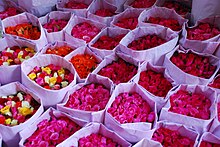
Pak Khlong Talat


Pak Khlong Talat (Thai: ปากคลองตลาด, pronounced [pàːk kʰlɔ̄ːŋ tā.làːt]) is a market in Wang Burapha Phirom Subdistrict, Phra Nakhon District, Bangkok, Thailand, that sells flowers, fruits, and vegetables. It is the primary flower market of Bangkok[1][2] and has been cited as a "place of symbolic value" to Bangkok residents.[3] It is on Chak Phet Road and adjacent side-streets, close to Memorial Bridge.[2] Though the market is open 24 hours, it is busiest before dawn, when boats and trucks arrive with flowers from nearby provinces.[4][5] Its location by Chao Phraya River near the southern end of Khlong Lot, hence the name 'Pak Khlong Talat', literally means "the market on the mouth of the canal".
History
[edit]During the reign of Rama I (1782–1809), the site was a floating market. By the reign of Rama V (1868–1910), it had become a fish market.[2] The fish market was eventually converted to today's produce market, which has existed for over 60 years.[1][2] The market's focus has shifted from produce to flowers as the Talat Thai market on the outskirts of Bangkok has become a more attractive site for produce wholesaling.[1]
Most of the flowers sold in the market are delivered from Nakhon Pathom, Samut Sakhon, and Samut Songkhram Provinces, though flowers that require cooler growing temperatures may come from as far away as Chiang Mai or Chiang Rai.[2] The market's produce selection is extensive and is delivered from across the country.[1]
The market accommodates both consumers and wholesalers and has a wide variety of customers. Many local florists visit the market in the early morning hours to stock their shops for the coming day.[6] The urban poor who make a living stringing and selling phuang malai (flower garlands) buy sacks of jasmine and marigold blossoms.[6] Though the market is documented in guidebooks,[7] it receives few foreign tourists.[6]
In 2016, outdoor vendors at Pak Khlong Talat were forced to move indoors.[8][9][10]
Yodpiman River Walk
[edit]
Yodpiman River Walk, usually shortened to Yodpiman (Thai: ตลาดยอดพิมาน, pronounced [tā.làːt jɔ̂ːt) pʰí(ʔ).māːn]) is a good atmosphere community mall on the diversion of Chao Phraya River near Memorial Bridge. Yodpiman can be considered as part of Pak Khlong Talat.
It is located behind Pak Khlong Talat, the building has three floors in a colonial style with serving restaurants, cafés, bakeries, banks, souvenir shops, clothing stores, and there is a terrace for walks and sightseeing along the banks of the Chao Phraya River. From this terrace, looking at the opposite (Thonburi side) you can see Santa Cruz Church, ubosot (ordination hall) of Wat Prayurawongsawat and Wat Kalayanamitr, three Thai-style white pavilions that is the head office of City Law Enforcement Department, Wichai Prasit Fort and prang (Khmer-style pagoda) of Wat Arun clearly.[11]
Formerly, its location was once a warehouse and an old port that is around 50–60 years old, include used to be a flower market since 1961. Until in early 2016, it has been upgraded to a new landmark of Rattanakosin Island and Chao Phraya River.[12] [13]
Moreover, Yodpiman Riverwalk is also a pier for Chao Phraya Express Boat with designated pier number N6/1, it can be considered as a pier in the middle between Rajinee (N7) and Memorial Bridge Piers (N6).[14] From here you can take a boat to other nearby attractions such as Tha Tian, Wat Pho etc. 13°44′30.4″N 100°29′46.7″E / 13.741778°N 100.496306°E
Transportation
[edit]The market is served by BMTA bus lines: 1, 2, 3, 7ก, 8, 9, 12, 33, 42, 47, 53, 60, 73, 73ก, 82
It is close to Sanam Chai Station on the MRT's Blue Line, as well as having access to three piers of the Chao Phraya Express Boat: Memorial Bridge (N6), Yodpiman (N6/1), and Rajini (N7)
References
[edit]- ^ a b c d Sukphisit, Suthon. "A Tale of Two Markets". Bangkok Post (11 November 2006).
- ^ a b c d e "Night Shopping"Bangkok Post (20 April 2006) Archived 15 May 2008 at the Wayback Machine
- ^ Kongrut, Anchalee. "More space for culture, arts sought". Bangkok Post (24 June 2004).[dead link]
- ^ Evans, Christopher and Lindsay Evans. Thailand. Hunter Publishing (2006), p 89. ISBN 1-58843-518-0.
- ^ Warren, William. Bangkok. Reaktion (2002), p 127. ISBN 1-86189-129-6.
- ^ a b c Kazmin, Amy. "A night of scented breezes". Financial Times (1 May 2004).
- ^ Cummings, Joe. Thailand. Lonely Planet (2005), p178. ISBN 1-74059-697-8.
- ^ Williams, Sarah. "Blooming Gorgeous: Inside Bangkok's Flower Market". Culture Trip. Retrieved 28 October 2020.
- ^ "Flower Market | Bangkok, Thailand Attractions". Lonely Planet. Retrieved 28 October 2020.
- ^ "Pak Khlong Talat: Bangkok's iconic 24-hour flower market". Experience Unique Bangkok. 28 April 2017. Retrieved 28 October 2020.
- ^ "ชวนไปเดินชิลริมน้ำ : "ยอดพิมาน ริเวอร์วอล์ก" คอมมูนิตี้มอลล์วิวแม่น้ำเจ้าพระยา ที่น่าไปเช็คอินสุดๆ" [Invite to stroll on the waterfront: "Yodpiman River Walk" Chao Phraya River community mall view, that should go to check in]. Chillpainai (in Thai). 3 April 2016.
- ^ ""ยอดพิมานริเวอร์ วอล์ค" ตลาดดอกไม้ในตึกริมน้ำ ปั้นโกดังเก่าเป็นแลนด์มาร์กแห่งใหม่เกาะกรุงรัตนโกสินทร์" ["Yodpiman River Walk" flower market in waterside building, create an old warehouse as a new landmark, Rattanakosin Island]. Manager Online (in Thai). 5 February 2016.
- ^ "เดินเล่นท่าเรือริมน้ำเจ้าพระยา ท่ามหาราช ยอดพิมาน เอเชียทีค เดอะ ริเวอร์ฟร้อนท์" [Stroll along the Chao Phraya waterfront piers, Tha Maharaj, Yodpiman, Asiatique: The Riverfront]. Star-traveller.com (in Thai). Archived from the original on 25 October 2021. Retrieved 10 May 2023.
- ^ "เรือด่วนเจ้าพระยา: เรือด่วนเจ้าพระยา" [Chao Phraya Express Boat: Chao Phraya Express Boat]. transit Bangkok (in Thai).
13°44′32″N 100°29′48″E / 13.742209°N 100.496567°E
