Mount Glorious
| Mount Glorious Queensland | |||||||||||||||
|---|---|---|---|---|---|---|---|---|---|---|---|---|---|---|---|
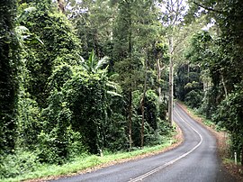
 Following the mountain's ridge on Mount Glorious Road through D'Aguilar National Park, 2016 | |||||||||||||||
 | |||||||||||||||
| Coordinates | 27°19′22″S 152°46′57″E / 27.3227°S 152.7825°E | ||||||||||||||
| Population | 343 (2021 census)[1] | ||||||||||||||
| • Density | 16.65/km2 (43.12/sq mi) | ||||||||||||||
| Established | 1903 | ||||||||||||||
| Postcode(s) | 4520 | ||||||||||||||
| Area | 20.6 km2 (8.0 sq mi) | ||||||||||||||
| Time zone | AEST (UTC+10:00) | ||||||||||||||
| Location |
| ||||||||||||||
| LGA(s) | City of Moreton Bay | ||||||||||||||
| State electorate(s) | Pine Rivers | ||||||||||||||
| Federal division(s) | Dickson | ||||||||||||||
| |||||||||||||||
Mount Glorious is a rural locality in the City of Moreton Bay, Queensland, Australia.[2] In the 2021 census, Mount Glorious had a population of 343 people.[1]
Geography
[edit]Mount Glorious is a mountain which is part of the D'Aguilar Range and is a suburb in City of Moreton Bay. It is 41.1 kilometres (25.5 mi) by road north-west of the Brisbane CBD.[3] The forest that surrounds the mountain village is part of Brisbane Forest Park and the D'Aguilar National Park.
The locality has the following mountains (from north to south):
- Mount Samson (27°18′09″S 152°48′04″E / 27.3025°S 152.8012°E) 690 metres (2,260 ft)[4][5]
- Mount D'Aguilar (27°18′13″S 152°46′15″E / 27.3036°S 152.7709°E) 742 metres (2,434 ft)[4][6]
- Mount Glorious (27°20′06″S 152°46′04″E / 27.3350°S 152.7678°E) 619 metres (2,031 ft)[4][7]
Other mountains in the D'Aguilar Range (but not in this locality) include Mount Nebo, Mount Pleasant and Mount Mee.
History
[edit]The locality name takes its name from the mountain, which was named as the result of a random remark by Elizabeth Patrick at a 1915 picnic, when she commented on the view.[2]
Five blocks on the mountain were made available early in the 20th century, with the first block being bought by James O'Hara in 1903.[8] In 1921, a real estate map advertised 31 blocks as 'Crest Estate : the first section', being subdivisions of Portion 9, Parish of Parker.[9][10]
The mountain was the centre of a 4.4 magnitude earthquake in November 1960.[11]
Demographics
[edit]In the 2016 census, Mount Glorious recorded a population of 296 people, 48.6% female and 51.4% male.[12] The median age of the Mount Glorious population was 49 years, 11 years above the national median of 38. 69.4% of people living in Mount Glorious were born in Australia. The other top responses for country of birth were England 9.3%, New Zealand 4.5%, Netherlands 1.0%, Italy 1.0% and India 1.0%. 88.0% of people spoke only English at home; the next most common languages were Dutch 1.0%, and Sinhalese 1.0% [12]
In the 2021 census, Mount Glorious had a population of 343 people.[1]
Education
[edit]There are no schools in Mount Glorious. The nearest government primary schools are Mount Samson State School in neighbouring Mount Samson to the north-east and Mount Nebo State School in neighbouring Mount Nebo to the south. The nearest government secondary school is Ferny Grove State High School in Ferny Grove to the south-east.[13]
Amenities
[edit]The Moreton Bay City Council operates a mobile library service which visits the Mount Glorious Hall on Mount Glorious Road.[14]
See also
[edit]References
[edit]- ^ a b c Australian Bureau of Statistics (28 June 2022). "Mount Glorious (SAL)". 2021 Census QuickStats. Retrieved 28 February 2023.
- ^ a b "Mount Glorious – locality in Moreton Bay Region (entry 45453)". Queensland Place Names. Queensland Government. Retrieved 16 November 2019.
- ^ "Brisbane CBD to Mount Glorious" (Map). Google Maps. Retrieved 28 May 2022.
- ^ a b c "Mountain peaks and capes - Queensland". Queensland Open Data. Queensland Government. 12 November 2020. Archived from the original on 25 November 2020. Retrieved 25 November 2020.
- ^ "Mount Samson – mountain in Moreton Bay Region (entry 29554)". Queensland Place Names. Queensland Government. Retrieved 25 November 2020.
- ^ "Mount D'Aguilar – mountain in Moreton Bay Region (entry 9159)". Queensland Place Names. Queensland Government. Retrieved 25 November 2020.
- ^ "Mount Glorious – mountain in Moreton Bay Region (entry 14064)". Queensland Place Names. Queensland Government. Retrieved 25 November 2020.
- ^ Horton, Helen (1988). Brisbane's Back Door: The story of the D'Aguilar Range. Bowen Hills, Queensland: Boolarong Publications. p. 28. ISBN 0-86439-036-X.
- ^ "Mount Glorious Crest Estate : the first section" [Map]. Collections. State Library of Queensland.
- ^ "Advertising". The Brisbane Courier. No. 19, 711. Queensland, Australia. 24 March 1921. p. 12. Retrieved 30 April 2019 – via National Library of Australia.
- ^ Daniel Hurst (24 April 2008). "Qld earthquake risk real". Brisbane Times. Fairfax Digital. Archived from the original on 27 April 2009. Retrieved 27 April 2008.
- ^ a b Australian Bureau of Statistics (27 June 2017). "Mount Glorious (SSC)". 2016 Census QuickStats. Retrieved 20 October 2018.
- ^ "Queensland Globe". State of Queensland. Retrieved 28 May 2022.
- ^ "Mobile Library". Moreton Bay Regional Council. Archived from the original on 30 January 2018. Retrieved 30 January 2018.
External links
[edit]- Mount Glorious - Website about Mount Glorious

