Ablain-Saint-Nazaire
Ablain-Saint-Nazaire | |
|---|---|
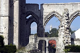
 Ruins of the church destroyed during World War I | |
| Coordinates: 50°23′34″N 2°42′48″E / 50.3928°N 2.7133°E | |
| Country | France |
| Region | Hauts-de-France |
| Department | Pas-de-Calais |
| Arrondissement | Lens |
| Canton | Bully-les-Mines |
| Intercommunality | Lens-Liévin |
| Government | |
| • Mayor (2014-2020) | Dominique Robillart |
| Area 1 | 9.85 km2 (3.80 sq mi) |
| Population (2014) | 1,779 |
| • Density | 180/km2 (470/sq mi) |
| Time zone | UTC+01:00 (CET) |
| • Summer (DST) | UTC+02:00 (CEST) |
| INSEE/Postal code | 62001 /62153 |
| Elevation | 77–188 m (253–617 ft) (avg. 95 m or 312 ft) |
| 1 French Land Register data, which excludes lakes, ponds, glaciers > 1 km2 (0.386 sq mi or 247 acres) and river estuaries. | |
Ablain-Saint-Nazaire is a commune in the Pas-de-Calais department in northern France.
Geography
A farming village located 8 miles (12 km) north of Arras, on the D57 road. It was rebuilt after being destroyed during World War I. The Saint-Nazaire stream, which passes through the commune, is a small tributary of the river Deûle.
Population
| Year | Pop. | ±% |
|---|---|---|
| 1962 | 1,295 | — |
| 1968 | 1,293 | −0.2% |
| 1975 | 1,388 | +7.3% |
| 1982 | 1,482 | +6.8% |
| 1990 | 1,715 | +15.7% |
| 1999 | 1,843 | +7.5% |
| 2005 | 1,890 | +2.6% |
| 2009 | 1,828 | −3.3% |
| 2014 | 1,779 | −2.7% |
History
At the start of World War I, the Battle of Lorette lasted for 12 months, from October 1914 to October 1915, resulting in high casualties on both sides: 100,000 killed and as many wounded. A French national cemetery was built on 13 hectares nearby and comprises 20,000 graves, laid out irrespective of rank or military training. General Barbot has a private soldier buried next to him, on his right. In eight ossuaries, around the base of the lantern tower, are the remains of 22,970 unidentified soldiers. A portion of the cemetery has been reserved for Muslim soldiers.
Sights
- The church of St. Pierre, dating from the twentieth century.
- The ruins of the fifteenth century church, destroyed in World War I.
- The war museum.


