
Charles M. Schulz–Sonoma County Airport
Charles M. Schulz–Sonoma County Airport (former Santa Rosa Army Airfield) | |||||||||||||||
|---|---|---|---|---|---|---|---|---|---|---|---|---|---|---|---|
.png) | |||||||||||||||
 USGS 2006 orthophoto | |||||||||||||||
| Summary | |||||||||||||||
| Airport type | Public | ||||||||||||||
| Owner/Operator | Sonoma County DOT | ||||||||||||||
| Serves | Sonoma County, California | ||||||||||||||
| Location | Sonoma County, near Santa Rosa, California | ||||||||||||||
| Operating base for | Avelo Airlines[1] | ||||||||||||||
| Elevation AMSL | 129 ft / 39 m | ||||||||||||||
| Coordinates | 38°30′32″N 122°48′46″W / 38.50889°N 122.81278°W | ||||||||||||||
| Website | sonomacountyairport | ||||||||||||||
| Maps | |||||||||||||||
 FAA airport diagram | |||||||||||||||
 | |||||||||||||||
| Runways | |||||||||||||||
| |||||||||||||||
| Statistics (2017) | |||||||||||||||
| |||||||||||||||
Charles M. Schulz–Sonoma County Airport (IATA: STS, ICAO: KSTS, FAA LID: STS) is a domestic airport located 7 miles (11 km) northwest of downtown Santa Rosa, California, in Sonoma County, California, United States.[2][3]
The airport is named after Charles M. Schulz, the famed cartoonist of the Peanuts comic strip, who lived in Santa Rosa for more than 30 years. The airport's logo features Snoopy in World War I flying-ace attire atop his doghouse.
History[edit]
Military use[edit]
In the 1930s Santa Rosa had a small municipal airfield owned by Richfield Oil Corporation next to the Redwood Highway about 6 miles southeast of the present airport. Use of the 3,000-foot sod runway at the earlier airfield was discontinued during World War II as facilities at the present airport improved.[4]
Opened in June 1942 and known as Santa Rosa Army Air Field, the airfield was assigned to Fourth Air Force as a group and replacement training airfield. Known units assigned to Santa Rosa were:
- 354th Fighter Group, March–June 1943
- 357th Fighter Group, June–August 1943
- 363d Fighter Group, August–October 1943
- 367th Fighter Group, October–December 1943
The 478th Fighter Group was permanently assigned to Santa Rosa in December 1943 and began training replacement pilots, who were sent to combat units overseas after graduation.
The airfield was inactivated on January 31, 1946 during winter and turned over to the War Assets Administration for eventual conversion to a civil airport.
Airline flights[edit]
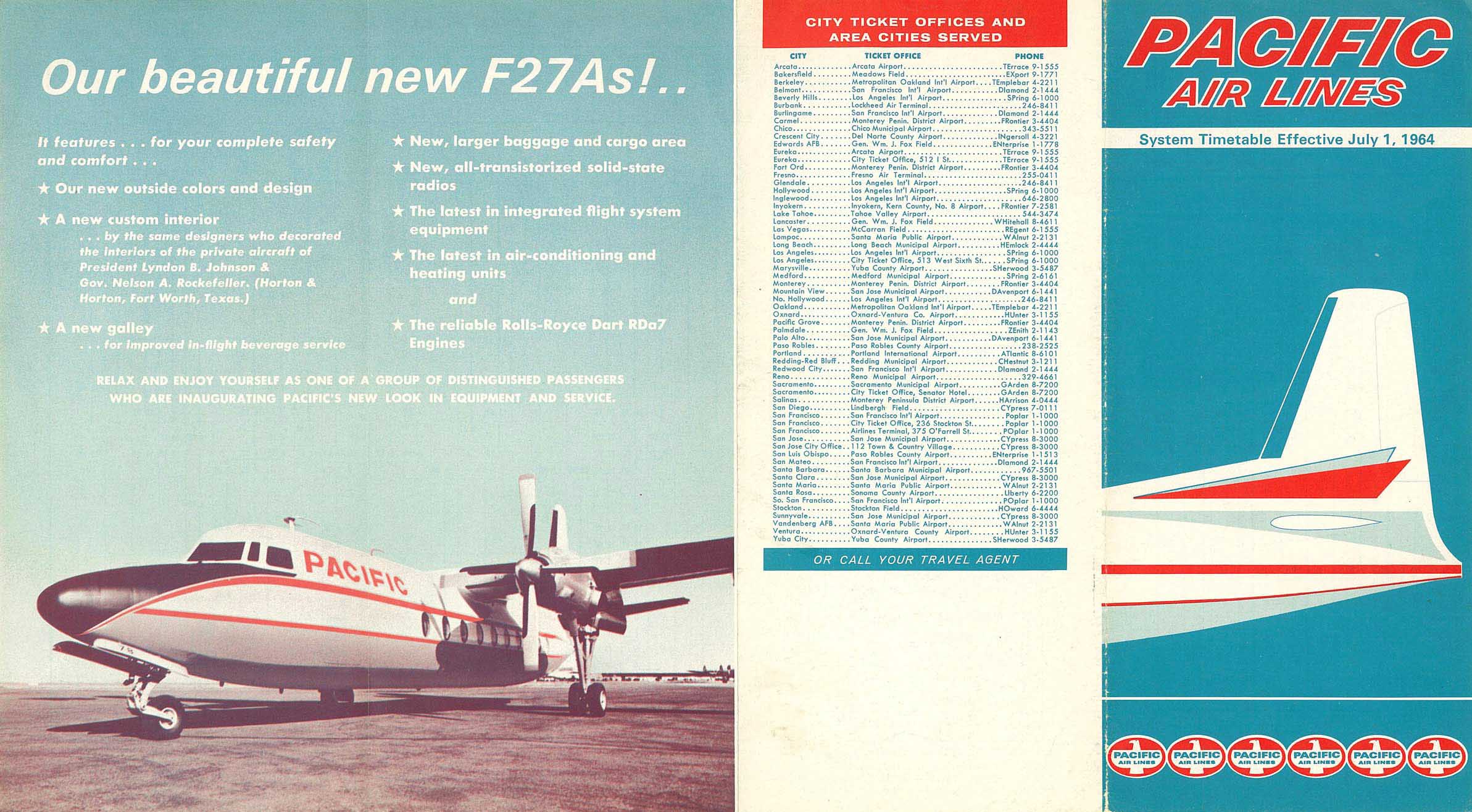
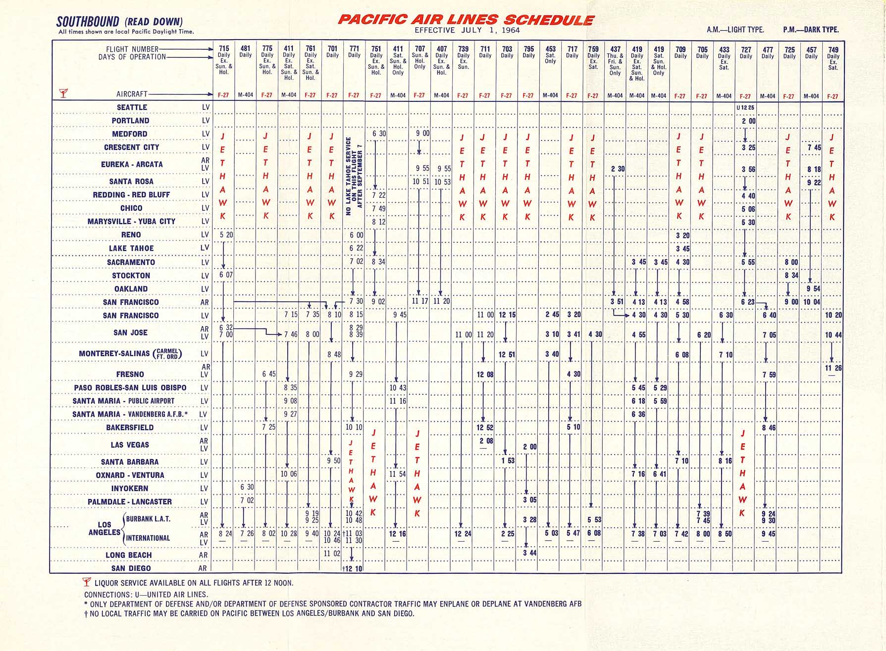
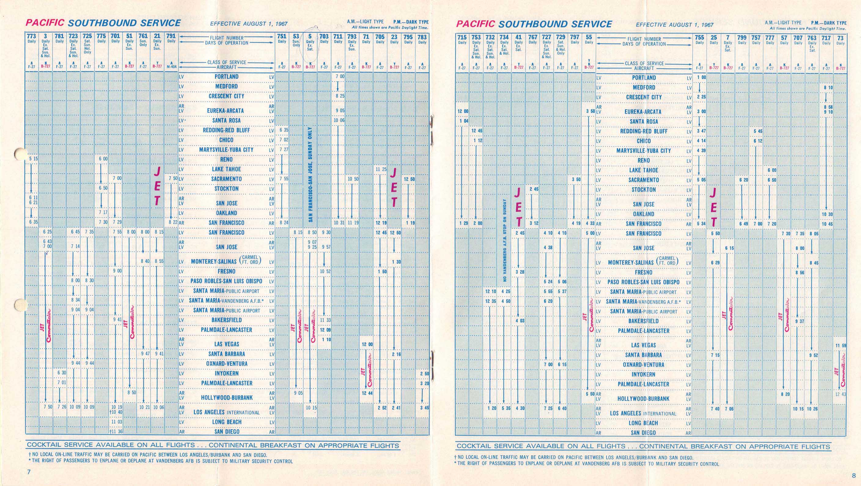
From the late-1940s to the mid-1970s Southwest Airways and successors Pacific Air Lines, Air West and Hughes Airwest served Santa Rosa. Southwest Airways Douglas DC-3s followed by Pacific, Air West and Hughes Airwest Fairchild F-27 turboprops mainly flew to San Francisco (SFO). Pacific Air Lines had introduced F-27 aircraft on its Santa Rosa service by 1964 with these new propjets subsequently replacing the airline's Martin 4-0-4 piston-powered aircraft on all of its flights into airport.[5][6] In 1967 Pacific was operating daily F-27 service on a roundtrip routing of Portland, OR - Crescent City - Eureka/Arcata - Santa Rosa - San Francisco.[7][8] By 1968, one of the Air West F-27 flights serving the airport was operating a daily southbound routing of Redding - Santa Rosa - Oakland - San Francisco.[9] In the summer of 1972, Hughes Airwest was operating two nonstop F-27 flights every weekday to San Francisco.[10][11] However, by 1975 Hughes Airwest was no longer serving Santa Rosa.[12]
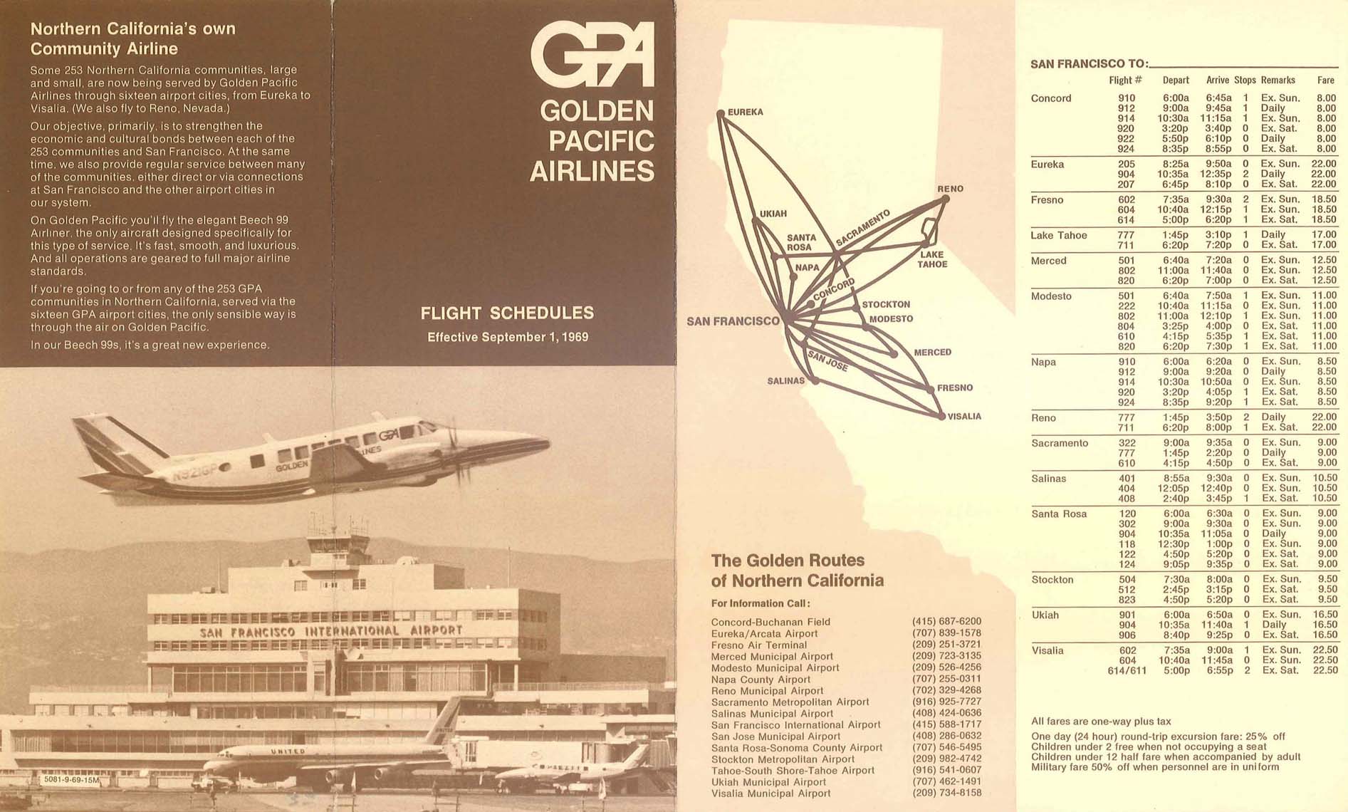
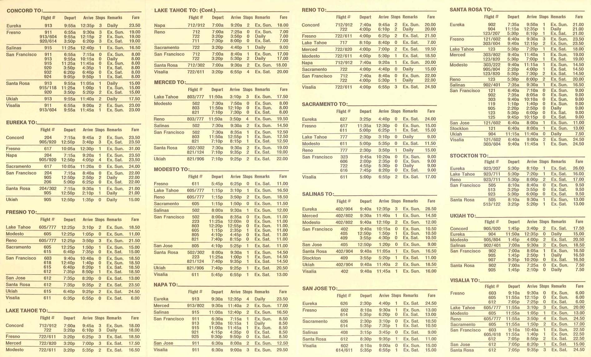
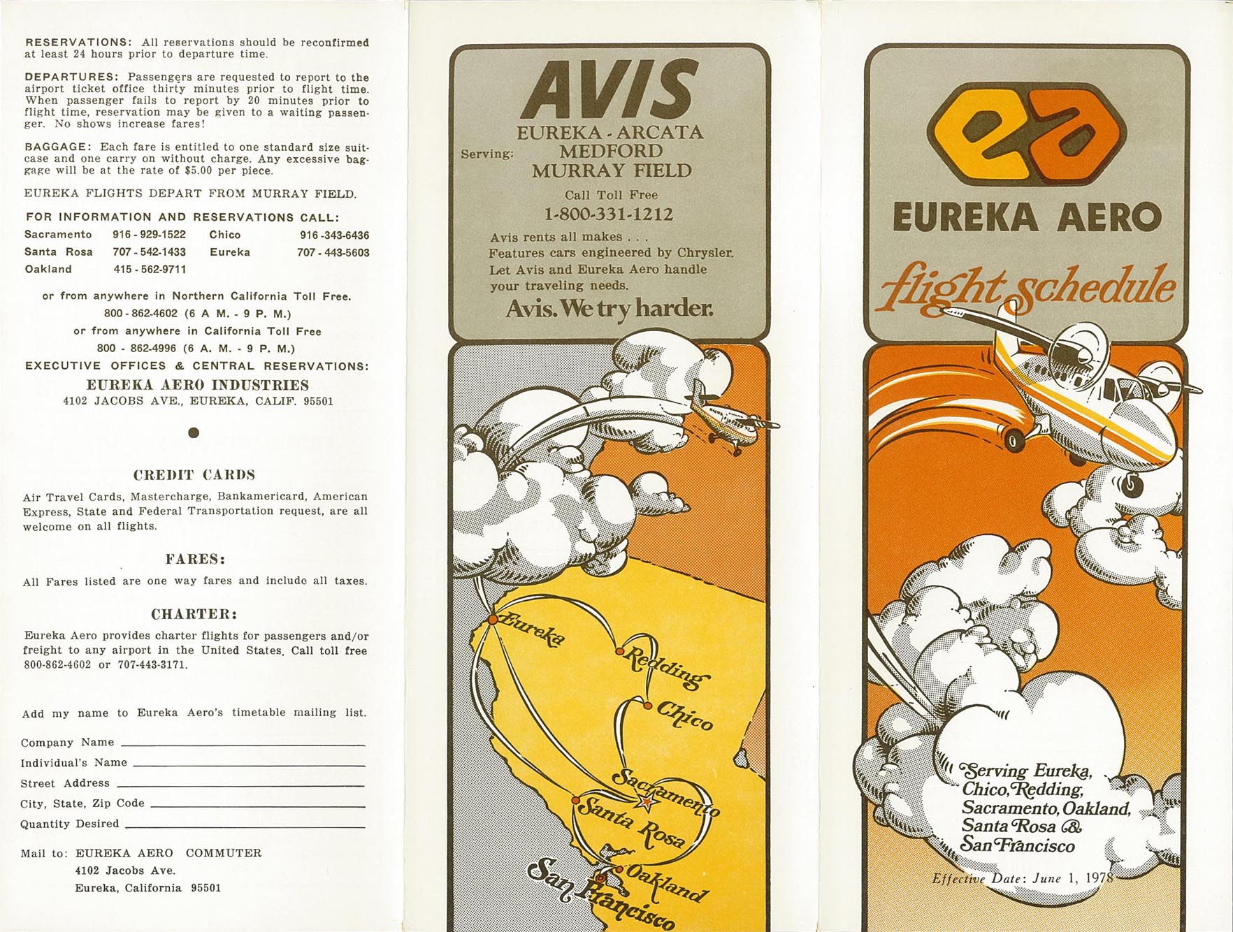
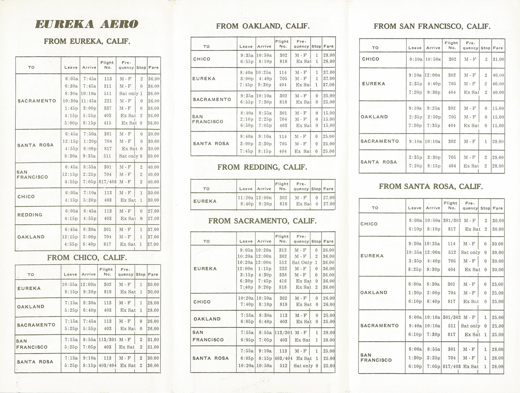
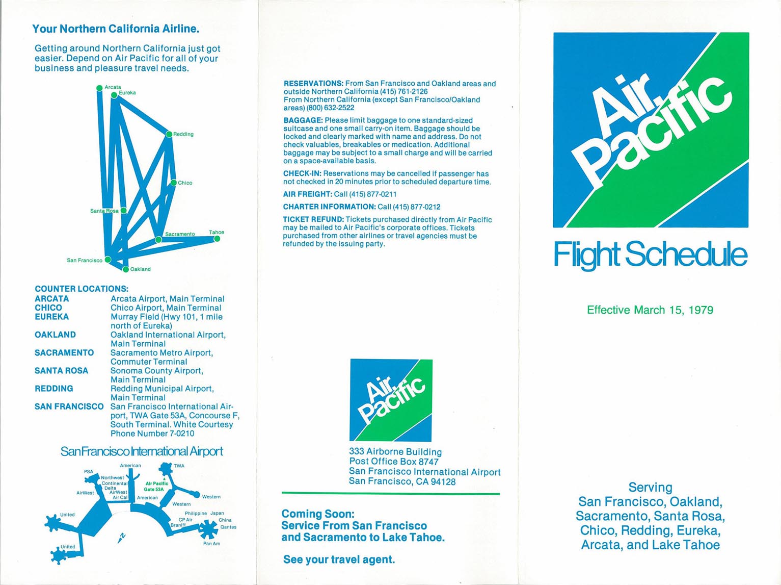
Commuter airlines flew STS to San Francisco (SFO) until 2001 as well as to San Jose (SJC) at various times. In 1969 Golden Pacific Airlines (1969-1973) was operating six roundtrip flights every weekday between the airport and SFO as well as direct flights to Eureka, Lake Tahoe, Reno, Stockton and Ukiah with Beechcraft 99 commuter turboprops [13] During the mid and late 1970s Eureka Aero and successor Air Pacific (United States) operated de Havilland Canada DHC-6 Twin Otter service to Eureka, Oakland, Sacramento and San Francisco.[14][15][16] In 1985 Westates Airlines Convair CV-580 turboprops flew nonstop to Los Angeles for several months before ceasing operations; their July 1985 timetable listed 38 round trips a week between STS and LAX. Other turboprop flights included American Eagle Fairchild Swearingen Metroliners operated by Wings West Airlines for American Airlines nonstop to SFO and San Jose (SJC). In late 1989 American Eagle had three Metros a day to SFO and four a day to SJC.[17] In 1995 Reno Air Express was operating codeshare BAe Jetstream 31 nonstop service from Eureka/Arcata, Reno and San Jose flown by Mid Pacific Air on behalf of Reno Air.[18]
In the mid-1980s United Airlines entered into a code sharing agreement with WestAir, a commuter airline that had previously served STS with Cessna 402s and de Havilland Canada DHC-6 Twin Otters to San Francisco.[19][20] WestAir then began flying as United Express to SFO until 2001.[21] Westair operated its United Express service with Embraer EMB-110 Bandeirante, Short 360, BAe Jetstream 31 and Embraer EMB-120 Brasilia turboprops.[17][22][18]
In 1989 jet service arrived in Santa Rosa when WestAir operating as United Express began flying four weekday BAe 146-200 nonstops to Los Angeles, soon replaced with Embraer EMB-120 Brasilia turboprops with this service to LAX then ending in 1991. The Westair BAe 146s were Santa Rosa's only jet flights until Allegiant Air jets appeared on May 19, 2016 followed by American Eagle on February 16, 2017.[23] WestAir formerly operated as Stol Air Commuter flying Britten-Norman Islanders and Trislanders to San Francisco. Stol Air Commuter had administrative offices in Santa Rosa. In June 2001 United Express operated by SkyWest Airlines was the only airline serving Santa Rosa with six Embraer EMB-120 Brasilia flights a day into the airport including four daily nonstops from Los Angeles (LAX) and two flights a day from San Francisco (SFO).[24] United Express then left Santa Rosa later in 2001 (and would not return until 2017) with the airport not having any scheduled passenger airline service for several years during the early and mid-2000s.
In March 2007 airline service resumed; Horizon Air, a subsidiary of Alaska Airlines, began flights to Seattle/Tacoma and Los Angeles operated with Bombardier Q400 propjets. Horizon then added flights to Portland, Oregon in late 2007, to Las Vegas in early 2008,[25] and to San Diego in mid 2012.
In early 2011 Alaska Airlines announced it would retire its Horizon brand,[26] and all flights operated by Horizon now use the Alaska Airlines name. In June 2012 the airline ended flights from STS to Las Vegas.[27]
As part of an agreement between the airport, Alaska Airlines, and the local enotourism industry, it was announced in January 2012 that passengers were allowed to check a 12-bottle case of wine for free on all Alaska Airlines flights from the airport.[28]
Most Alaska Airlines flights from Santa Rosa are currently operated with 76-seat Embraer E175 regional jets.[29] The exception is mainline Boeing 737-800 jetliner service nonstop to Seattle.[30] Alaska E-175s currently fly nonstop to Burbank, Los Angeles, Orange County, Portland, San Diego, and Seattle.[31]
New jet service[edit]
In March 2016 Allegiant Air announced it would begin flying McDonnell Douglas MD-83s nonstop to Las Vegas McCarran International Airport and nonstop to Phoenix-Mesa Gateway Airport (IWA).[32] The Las Vegas flight began on May 19, 2016 and the Phoenix flight several days later. At the time, the MD-83 was the largest airliner ever scheduled to Santa Rosa; as of October 19, 2016, Allegiant switched from the 166 seat MD-83 to the 155 seat Airbus A319. Allegiant ended flights to Phoenix-Mesa on January 2, 2017 and to Las Vegas on June 30, 2017 and no longer serves Santa Rosa.
In October 2016 American Airlines announced it would begin nonstop service between Santa Rosa and its hub in Phoenix (PHX) on February 16, 2017. The daily code share flight was being operated by SkyWest Airlines as American Eagle with Canadair CRJ-700s. American Eagle then added a second nonstop CRJ-700 roundtrip flight to Phoenix and currently operates one Canadair CRJ-900 roundtrip flight per day between Phoenix and Santa Rosa.[33] American Eagle announced it would begin flying Embraer 175s nonstop to Los Angeles (LAX) effective May 3, 2019 and nonstop to Dallas/Fort Worth (DFW) effective June 6, 2019. American Eagle currently operates nonstop jet flights to PHX and seasonally to DFW from Santa Rosa.[33]
In February 2017 United Express announced their return to Santa Rosa with thrice daily service to the United Airlines hub in San Francisco (SFO). The flights began on June 8, 2017; SkyWest Airlines Canadair CRJ-200s operate the code sharing flights for United. United Express announced it would begin nonstop CRJ-200 regional jet flights to Denver on March 8, 2019 .[34] However, United Express is currently not operating any service from Santa Rosa.[29]
In March 2017 Sun Country Airlines announced seasonal nonstop service between Santa Rosa and Minneapolis/St. Paul International Airport, to operate from late summer until late fall.[35] Sun Country was operating weekly 162 seat Boeing 737-800s from August 24, 2017 through December 3, 2017, connecting via Minneapolis/St. Paul to Boston, New York John F. Kennedy Airport and Washington Reagan National Airport. Sun Country then continued to operate from the airport but had ended all service to Ronald Reagan Washington National Airport and was serving Washington Dulles Airport instead at the time.[36] In May 2018 Sun Country Airlines made a surprise announcement that it would be adding a new seasonal destination from Santa Rosa with nonstop flights between STS and Las Vegas (LAS) in addition to its seasonal nonstop service between the airport and MSP. The Sun Country fleet is composed of Boeing 737-700s and 737-800s, which were the largest aircraft types serving the airport at the time.[36] Sun Country ceased serving Santa Rosa in early 2020.[37]
Avelo Airlines began nonstop service to the Hollywood Burbank Airport (BUR) in the Los Angeles area on April 28, 2021 and then subsequently added nonstop flights to Las Vegas with Boeing 737-800 mainline jetliners which are currently the largest aircraft type serving Santa Rosa in scheduled passenger service.[38] Avelo also operates Boeing 737-700 jetliners into the airport.[39] Alaska Airlines has since begun nonstop jet service from the airport to BUR as well.[40] Avelo has announced it will establish a base in Santa Rosa with two 737 jet aircraft to be based at the airport as well as expanding its nonstop service from STS in early May 2024 to several new destinations in the western U.S. [41]
With the retirement of all Bombardier Q400 turboprop aircraft from the Alaska Airlines fleet in late January 2023, all Alaska Airlines flights from Santa Rosa are currently operated either with Embraer E175 regional jets or with mainline Boeing 737-800 jetliners.[42][30]
Facilities[edit]

The airport covers 1,125 acres (455 ha) at an elevation of 129 feet (39 m). It has two asphalt runways: 02/20 is 5,202 by 100 feet (1,586 x 30 m) and 14/32 is 6,000 by 150 feet (1,829 x 46 m).[2]
In 2017 the airport had 79,231 aircraft operations, average 217 per day: 83% general aviation, 10% air taxi, 6% airline and 1% military. Three hundred fifteen aircraft were then based at this airport: 85% single-engine, 12% multi-engine, 2% jet, and 1% helicopter.[2]
In August 2013 the airport started a project to decouple the ends of the two runways and extend runway 14/32 by 885 feet, to 6000 feet and extend runway 02/20 by 200 feet, to 5202 feet. This project was scheduled for completion in November 2014.[43][44]
The influx of new passengers in the late 2010s left existing airport facilities under severe strain. As a stopgap solution, the airport invested in a $4-million "tent" to serve as gate 2, which opened on October 22, 2021.[45] This has allowed the airport to double the area for outbound passenger seating, open a second passenger screening lane with TSA PreCheck capabilities, and replace portable restrooms with permanent units.[46]
As a more permanent solution, the airport has begun construction on an all-new terminal building. In the initial plan, the new terminal would add 19,000 square feet of new space at a cost of $20 million.[47] However, as passenger growth surpassed projections, the project was expanded so that the new terminal would be 40,000 square feet (33,000 square feet of new space and 7,000 of renovated space) at a cost of $31 million.[48] It will include a new gate 1 (replacing the old modular facility), additional space for concessions, an outdoor patio with seating and dining, a two new baggage claim systems, relocation of rental car desks, and a new ticketing lobby. Additionally, it will include space for two passenger screening lines, allowing them to be relocated from the gate 2 tent.[49] The terminal broke ground in late 2020 and opened in November 2022, with the full airport modernization project concluding in August 2023.[47][50]
Ground transportation[edit]
The U.S. 101 freeway is accessible to the airport via Airport Boulevard. Both short-term and long-term parking is available. Long-term parking is split into two lots within walking distance to the north and southeast of the terminal.[51]
A Sonoma–Marin Area Rail Transit (SMART) Airport station was constructed about 1.5 miles (2.4 km) from the airline passenger terminal on Airport Boulevard[52] and shuttle buses are currently serving as the link between the two locations.
The airport is served by Sonoma County Transit bus route 62.[53] In addition, Mendocino Transit Authority routes 65 and 95 have limited pickups, and drop-offs by request.[54][55] Sonoma County Airport Express buses also connect the airport with the San Francisco Bay Oakland International Airport and San Francisco International Airport.[56]
Airlines and destinations[edit]
Passenger[edit]
| Airlines | Destinations |
|---|---|
| Alaska Airlines[57] | Burbank, Las Vegas (begins October 1, 2024),[58] Los Angeles, Orange County, Portland (OR), San Diego, Seattle/Tacoma |
| American Airlines[59] | Seasonal: Dallas/Fort Worth |
| American Eagle[60] | Phoenix–Sky Harbor |
| Avelo Airlines | Boise,[61] Burbank, Glacier Park/Kalispell,[61] Las Vegas, Palm Springs, Salem,[61] Tri-Cities (WA)[61] Seasonal: Redmond/Bend |
| Destinations map |
|---|
 Santa Rosa Destinations from Charles M. Schulz-Sonoma County Airport (Red) = Year-round destination (Green) = Seasonal destination (Blue) = Future destination |
Statistics[edit]
| Rank | Airport | Passengers | Carriers |
|---|---|---|---|
| 1 | Seattle/Tacoma, Washington | 56,750 | Alaska |
| 2 | Burbank, California | 46,870 | Alaska, Avelo |
| 3 | Los Angeles, California | 38,970 | Alaska, American |
| 4 | San Diego, California | 38,280 | Alaska |
| 5 | Orange County, California | 33,740 | Alaska |
| 6 | Phoenix, Arizona | 30,780 | American |
| 7 | Portland, Oregon | 21,710 | Alaska |
| 8 | Dallas/Fort Worth, Texas | 20,160 | American |
| 9 | Las Vegas, Nevada | 16,970 | Avelo |
| 10 | Palm Springs, California | 7,220 | Avelo |
| Rank | Airline | Passengers | Share |
|---|---|---|---|
| 1 | SkyWest | 277,000 | 43.83% |
| 2 | Avelo | 123,000 | 19.48% |
| 3 | Alaska | 99,400 | 15.73% |
| 4 | Envoy | 87,180 | 13.80% |
| 5 | Horizon | 38,300 | 6.06% |
Other uses[edit]
Sonoma Air Attack Base[edit]
The Sonoma Air Attack Base of the California Department of Forestry and Fire Protection (known as CDF or CAL FIRE) was established in 1964 at the northeast corner of the airport. Sonoma responds to an average of 300 calls per year. It has a battalion chief and a fire captain (air tactics group supervisors), a fire apparatus engineer (base manager) and six firefighters. Aircraft at Sonoma include one OV-10 Bronco (Air Attack 140) and two Grumman S-2 Tracker air tankers (classified as S-2Ts, Tankers 85 and 86.)

On average, the base pumps about 300,000 US gallons (1,000 m3) of retardant a year. With the base's pumps, four loading pits and equipment, Sonoma has a possible peak output of 120,000 US gallons (450 m3) of retardant each day. The base's immediate response area covers 4,000 square miles (10,000 km2) and includes Marin County and portions of the CDF Sonoma–Lake–Napa, Santa Clara, San Mateo–Santa Cruz, and Mendocino Units.
Pacific Coast Air Museum[edit]
The Pacific Coast Air Museum is at the southeast corner of the airport, next to the hangar used in the 1963 Hollywood all-star comedy movie, It's a Mad, Mad, Mad, Mad World. Known as the Butler Building, the hangar was built during World War II and is still in use.
See also[edit]
References[edit]
- ^ "Avelo Airlines Announces New Base at Bay Area's Sonoma County Airport". PRNewswire. January 30, 2024. Retrieved January 30, 2024.
- ^ a b c d FAA Airport Form 5010 for STS PDF, effective 2016-02-04.
- ^ "Sonoma County Airport". Geographic Names Information System. United States Geological Survey, United States Department of the Interior. Retrieved May 4, 2009.
- ^ Freeman, Paul. "Santa Rosa Municipal Airport, Santa Rosa, CA". Tripod.com. Archived from the original on June 29, 2011. Retrieved December 13, 2011.
- ^ "Pacific Air Lines System Timetable". Airline Timetable Images. July 1, 1964. Archived from the original on September 7, 2023. Retrieved September 1, 2023.
- ^ "Pacific Air Lines Schedule". Airline Timetable Images. July 1, 1964. Archived from the original on September 1, 2023. Retrieved September 1, 2023.
- ^ "Pacific Southbound Service". Airline Timetable Images. August 1, 1967. Archived from the original on September 1, 2023. Retrieved September 1, 2023.
- ^ "Pacific Northbound Service". Airline Timetable Images. August 1, 1967. Archived from the original on September 7, 2023. Retrieved September 1, 2023.
- ^ "Air West Flight Schedule". Airline Timetable Images. July 1, 1968. Archived from the original on September 7, 2023. Retrieved September 1, 2023.
- ^ "Hughes Airwest Route Map". Departed Flights. July 1, 1972. Archived from the original on October 16, 2023. Retrieved September 1, 2023.
- ^ "Hughes Airwest timetable". Departed Flights. July 1, 1972. Archived from the original on September 1, 2023. Retrieved September 1, 2023.
- ^ "Hughes Airwest July 1, 1975 Route Map". Archived from the original on September 1, 2023. Retrieved September 1, 2023.
- ^ "Golden Pacific Airlines Flight Schedules". Airline Timetable Images. September 1, 1969. Archived from the original on January 16, 2023. Second page
- ^ "Eureka Aero Flight Schedule". Airline Timetable Images. June 1, 1978. Archived from the original on October 6, 2023. Retrieved September 12, 2023. Second page
- ^ "Air Pacific Flight Schedule". Airline Timetable Images. March 15, 1979. Second page
- ^ Swartz, Karl L. "Eureka Aero route map, April 15, 1975". Departed Flights. Archived from the original on June 18, 2021. Retrieved December 18, 2020.
- ^ a b "Airlines and Aircraft Serving Santa Rosa Effective December 15, 1989". Official Airline Guide. Archived from the original on June 18, 2021. Retrieved December 18, 2020 – via Departed Flights.
- ^ a b "Airlines and Aircraft Serving Santa Rosa Effective April 2, 1995". Official Airline Guide. Archived from the original on June 8, 2020. Retrieved June 8, 2020 – via Departed Flights.
- ^ "Airlines and Aircraft Serving Santa Rosa Effective April 1, 1981". Official Airline Guide. Archived from the original on June 18, 2021. Retrieved December 18, 2020 – via Departed Flights.
- ^ "Airlines and Aircraft Serving Santa Rosa Effective February 15, 1985". Official Airline Guide. Archived from the original on June 18, 2021. Retrieved December 18, 2020 – via Departed Flights.
- ^ "United Express Discontinues Flights". Los Angeles Times. November 1, 2001. Archived from the original on July 15, 2012. Retrieved December 16, 2011.
- ^ "Airlines and Aircraft Serving Santa Rosa Effective October 1, 1991". Official Airline Guide. Archived from the original on January 27, 2021. Retrieved December 18, 2020 – via Departed Flights.
- ^ Moore, Derek (February 16, 2017). "American Airlines debuts service from Sonoma County to Phoenix". The Press Democrat. Archived from the original on June 22, 2021. Retrieved December 18, 2020.
- ^ "Airlines Serving Santa Rosa in June 2001". Departed Flights. August 23, 2023. Archived from the original on August 31, 2023. Retrieved August 31, 2023.
- ^ Hart, Steve (March 25, 2012). "Alaska Airlines service energizes Sonoma County airport". The Press Democrat. Archived from the original on March 29, 2012. Retrieved December 20, 2012.
- ^ Mutzabaugh, Ben (January 26, 2011). "Horizon Air to 'retire its public brand' in favor of Alaska Air". USA Today. Archived from the original on June 1, 2012. Retrieved December 16, 2011.
- ^ Digitale, Robert (July 17, 2012). "Sonoma County-San Diego flights boost Alaska Air ridership". The Press Democrat. Archived from the original on January 31, 2013.
- ^ Verel, Dan (January 20, 2012). "Tourism bureau, Alaska Air to jointly promote region". North Bay Business Journal. Archived from the original on January 28, 2012. Retrieved December 20, 2012.
- ^ a b "STS Schulz-Sonoma County Airport (STS/KSTS)". Archived from the original on April 6, 2023. Retrieved February 13, 2023.
- ^ a b "Flight Finder ✈ Schulz-Sonoma County (KSTS) - Seattle-Tacoma Intl (KSEA) - FlightAware". Archived from the original on May 4, 2023. Retrieved May 4, 2023.
- ^ "Flights from Santa Rosa". Alaska Airlines.
- ^ Mutzabaugh, Ben (March 8, 2016). "Fast-growing Allegiant adds 3 new cities, 22 new routes". USA Today. Archived from the original on March 8, 2016. Retrieved March 8, 2016.
- ^ a b "American Airlines Home Page--AA.COM-- AIRLINE RESERVATIONS AND AIRFARE SPECIALS". Archived from the original on November 28, 1999.
- ^ "United Airlines". Archived from the original on April 7, 2000.
- ^ "Sun Country Airlines Announces New Service To Santa Rosa/Sonoma County, California, And Austin, Texas". Sun Country Airlines. March 8, 2017. Archived from the original on March 12, 2017.
- ^ a b "Sun Country Airlines". Archived from the original on May 29, 2016. Retrieved March 8, 2017.
- ^ Fixler, Kevin (February 27, 2020). "Sun Country Airlines exits Sonoma County airport, ending Minneapolis, Las Vegas flights". The Press Democrat. Archived from the original on July 6, 2020. Retrieved August 11, 2020.
- ^ "Avelo Airlines | Official Site | Book Now and Save". Aveloair.com. Archived from the original on April 9, 2021. Retrieved May 9, 2022.
- ^ "STS Schulz-Sonoma County Airport (STS/KSTS) - FlightAware". Archived from the original on September 1, 2023. Retrieved September 1, 2023.
- ^ https://www.alaskaair.com Archived July 9, 2015, at the Wayback Machine, Where we fly
- ^ https://www.aveloair.com/company-news/avelo-airlines-announces-new-base-at-bay-area-sonoma-county-airport
- ^ "With the E175 flying Horizon's future, we bid farewell to the Q400". January 27, 2023. Archived from the original on February 13, 2023. Retrieved February 13, 2023.
- ^ "General Information". STS Runway Project. Sonoma County Airport. Archived from the original on February 22, 2014.
- ^ Brown, Matt (January 5, 2014). "Sonoma County airport expansion expected to be completed before next winter". The Press Democrat. Archived from the original on February 21, 2014. Retrieved February 4, 2014.
- ^ Airport, Charles M. Schulz-Sonoma County (October 28, 2020). "New Modular Gate 2 Now Open at Charles M. Schulz — Sonoma County Airport". Charles M. Schulz Sonoma County Airport. Archived from the original on June 4, 2021. Retrieved June 4, 2021.
- ^ "Sonoma County airport completes $4 million passenger tent project". Santa Rosa Press Democrat. October 31, 2020. Archived from the original on June 4, 2021. Retrieved June 4, 2021.
- ^ a b "Santa Rosa airport $31M new terminal project finally takes off". The North Bay Business Journal. November 12, 2020. Archived from the original on June 4, 2021. Retrieved June 4, 2021.
- ^ "$31 million renovation project begins at Santa Rosa airport. See what's coming". Santa Rosa Press Democrat. November 18, 2020. Archived from the original on June 4, 2021. Retrieved June 4, 2021.
- ^ Airport, Charles M. Schulz-Sonoma County (November 9, 2020). "Terminal Improvement and Modernization Project at Charles M. Schulz — Sonoma County Airport". Charles M. Schulz Sonoma County Airport. Archived from the original on June 4, 2021. Retrieved June 4, 2021.
- ^ "Sonoma County airport unveils terminal upgrades. Here's what is new". Santa Rosa Press Democrat. August 24, 2023. Archived from the original on August 28, 2023. Retrieved August 28, 2023.
- ^ "Parking". Sonoma County Airport. Archived from the original on March 29, 2020. Retrieved March 29, 2020.
- ^ Atkinson, Rollie (June 21, 2017). "County's airport is maxing out". Sonoma West Times & News. Archived from the original on July 4, 2017. Retrieved June 21, 2017.
- ^ "Maps and Schedules". sctransit.com. Archived from the original on March 29, 2020. Retrieved March 29, 2020.
- ^ "Mendocino Transit Authority Route 65". mendocinotransit.org. Archived from the original on March 29, 2020. Retrieved March 29, 2020.
- ^ "Mendocino Transit Authority Route 95". mendocinotransit.org. Archived from the original on March 29, 2020. Retrieved March 29, 2020.
- ^ "Sonoma County Airport Express Inc". Sonoma County Airport Express. Archived from the original on August 17, 2018. Retrieved December 14, 2017.
- ^ "Route maps". Archived from the original on April 8, 2022. Retrieved April 7, 2022.
- ^ https://sonomacounty.ca.gov/alaska-airlines-adds-direct-flights-from-charles-m-schulz-sonoma-county-airport-to-las-vegas
- ^ "American Airlines makes conflicting moves at Charles M. Schulz-Sonoma County Airport". Retrieved November 17, 2023.
- ^ "Flight schedules and notifications - View schedules and set up notifications - American Airlines". Archived from the original on February 2, 2017. Retrieved November 15, 2022.
- ^ a b c d "Avelo adds 4 new flights out of Sonoma County". February 21, 2024. Archived from the original on April 22, 2024.
- ^ a b "CA: CA: Charles M. Schulz - Sonoma County (STS)". Bureau of Transportation Statistics. Archived from the original on February 27, 2024. Retrieved February 27, 2024.
External links[edit]
- Official website
- Sonoma County Sheriff Helicopter Unit
- FAA Airport Diagram (PDF), effective April 18, 2024
- FAA Terminal Procedures for STS, effective April 18, 2024
- Resources for this airport:
- FAA airport information for STS
- AirNav airport information for KSTS
- ASN accident history for STS
- FlightAware airport information and live flight tracker
- NOAA/NWS weather observations: current, past three days
- SkyVector aeronautical chart, Terminal Procedures
![]() This article incorporates public domain material from the Air Force Historical Research Agency
This article incorporates public domain material from the Air Force Historical Research Agency
.svg)
- Airports in the San Francisco Bay Area
- 1942 establishments in California
- Airports established in 1942
- Airfields of the United States Army Air Forces in California
- Airports in Sonoma County, California
- Charles M. Schulz
- History of Santa Rosa, California
- Transportation in Santa Rosa, California
- Buildings and structures in Santa Rosa, California