
Ningxia
Template:Infobox Autonomous Region of China (PRC)
| Ningxia | |||||||||||||||||||||||||||||||||||
|---|---|---|---|---|---|---|---|---|---|---|---|---|---|---|---|---|---|---|---|---|---|---|---|---|---|---|---|---|---|---|---|---|---|---|---|
| Simplified Chinese | 宁夏 | ||||||||||||||||||||||||||||||||||
| Traditional Chinese | 寧夏 | ||||||||||||||||||||||||||||||||||
| Xiao'erjing | نٍ شيَا | ||||||||||||||||||||||||||||||||||
| Postal | Ningsia | ||||||||||||||||||||||||||||||||||
| |||||||||||||||||||||||||||||||||||
| Ningxia Hui Autonomous Region | |||||||||||||||||||||||||||||||||||
| Simplified Chinese | 宁夏回族自治区 | ||||||||||||||||||||||||||||||||||
| Traditional Chinese | 寧夏回族自治區 | ||||||||||||||||||||||||||||||||||
| Xiao'erjing | نٍ شيَا خُوِ ذُوْ ذِ جِ ثُوْ | ||||||||||||||||||||||||||||||||||
| |||||||||||||||||||||||||||||||||||
Ningxia (NHAR), formerly transliterated as Ninghsia, is an autonomous region (Ningxia Hui Autonomous Region) of the People's Republic of China. Located in Northwest China, on the Loess Plateau, Ningxia is crossed by the Yellow River. The Great Wall of China runs along its northeastern boundary. The region is the home of the Hui people, one of the 56 officially recognised Nationalities of China. The capital is Yinchuan.
Ningxia is bounded by Shaanxi (to the east) and Gansu (in all directions but the north) provinces and Inner Mongolia (to the north) Autonomous Region and has an area of around 66,400 square kilometres (25,600 sq mi). Formerly a province, Ningxia was incorporated into Gansu in 1954 but was detached and reconstituted as an autonomous region for the Hui people in 1958. This sparsely settled mostly desert region lies in the vast plain of the Yellow River in the north which has been irrigated for centuries. Over the years an extensive system of canals has been built. Extensive land reclamation and irrigation projects have made increased cultivation possible.
History
Ningxia and its surrounding areas were incorporated into the Qin Dynasty as early as the 3rd century BC. Throughout the Han Dynasty and the Tang Dynasty there were several large cities established in the region, and by the 11th century the Tangut tribe had established the Western Xia Dynasty on the outskirts of the then Song Dynasty.
It then came under Mongol domination after Genghis Khan conquered Yinchuan in the early 13th century. After the Mongols departed and its influences faded, some Turkic-speaking Muslims also began moving into Ningxia from the west. The Muslim Rebellion of the 19th century occurred here.
In 1914, Ningxia was merged with the province of Gansu; in 1928, however, it was detached and became a province. Between 1914 and 1928, the Xibei San Ma (literally "three Mas of the northwest") ruled the provinces of Qinghai, Ningxia and Gansu. Muslim Kuomintang General Ma Hongkui was the military Governor of Ningxia and had absolute authority in the province. In 1958, Ningxia formally became an autonomous region of China. In 1969, Ningxia received a part of the Inner Mongolian Autonomous Region, but this area was returned in 1979. It is nearly coextensive with the ancient kingdom of the Tangut people, whose capital was captured by Genghis Khan in the early 13th century.
A number of Chinese artifacts dating from the Tang dynasty and Song dynasty, some of which had been owned by Emperor Zhenzong were excavated and then came into the hands of Ma Hongkui, who refused to publicize the findings. Among the artifacts were a white marble tablet from the Tang dynasty, gold nails, and bands made out of metal. It was not until after Ma passed away, that his wife went to Taiwan in 1971 from America to bring the artifacts to Chiang Kai-shek, who turned them over to the Taipei National Palace Museum.[1]
Geography
Ningxia borders the provinces of Shaanxi and Gansu, and the Inner Mongolia Autonomous Region.
The Yellow River flows through Ningxia. The Ningxia ecosystem is one of the least studied regions in the world. Some plant genera in Ningxia have been estimated at over 40,000 years old.
Ningxia is a relatively dry, desert-like region. Significant irrigation supports the growing of wolfberries, a commonly consumed fruit throughout the region.
Ningxia's deserts include the Tengger desert in Shapotou.
The northern section, through which the Yellow River flows, supports the best agricultural land. A railroad, linking Lanzhou with Baotou, crosses the region. A highway has been built across the Yellow River at Yinchuan.
On 16 December 1920, the Haiyuan earthquake, 8.6 magnitude, at 36°36′N 105°19′E / 36.6°N 105.32°E, initiated a series of landslides that killed an estimated 200,000 people. Over 600 large loess landslides created more than 40 new lakes.[2][3]
In 2006, satellite images indicated that a 700 by 200-meter fenced area within Ningxia—5 km southwest of Yinchuan, near the remote village of Huangyangtan—is a near-exact 1:500 scale terrain model reproduction of a 450 by 350-kilometer area of Aksai Chin bordering India, complete with mountains, valleys, lakes and hills. Its purpose is as yet unknown.[4][5]
| Part of a series on Islam in China |
|---|
 |
|
|
Climate
The region is 1,200 kilometres (750 mi) from the sea and has a continental climate with average summer temperatures rising to 17 to 24 °C (63 to 75 °F) in July and average winter temperatures dropping to between −7 to −10 °C (19 to 14 °F) in January. Seasonal extreme temperatures can reach 39 °C (102 °F) in summer and −30 °C (−22 °F) in winter. The diurnal temperature variation can reach above 17 °C (31 °F), especially in spring. Annual rainfall averages from 190 to 700 millimetres (7.5 to 27.6 in), with more rain falling in the south of the region.
Environment
Governance
The politics of Ningxia is structured in a dual party-government system like all other governing institutions in mainland China.
The Chairman of the Autonomous Region is the highest ranking official in the People's Government of Ningxia. However, in the Autonomous Region's dual party-government governing system, the Chairman has less power than the Communist Party of China Ningxia Committee Secretary, colloquially termed the "Ningxia CPC Party Chief".
Ningxia has a friendship agreement with Sogn og Fjordane county of Norway.[6]
Administrative divisions
Ningxia is divided into five prefecture-level cities:
| Map | # | Name | Administrative Seat | Hanzi Hanyu Pinyin |
Xiao'erjing | Population (2010) |
|---|---|---|---|---|---|---|

| ||||||
| — Prefecture-level city — | ||||||
| 1 | Yinchuan | Xingqing District | 银川市 Yínchuān Shì |
ىٍ ﭼُﻮًا شِ | 1,993,088 | |
| 2 | Shizuishan | Dawukou District | 石嘴山市 Shízuǐshān Shì |
شِ ذُﻮِ شً شِ | 725,482 | |
| 3 | Wuzhong | Litong District | 吴忠市 Wúzhōng Shì |
ءُ ﺟْﻮ شِ | 1,273,792 | |
| 4 | Zhongwei | Shapotou District | 中卫市 Zhōngwèi Shì |
ﺟْﻮ وِ شِ | 1,080,832 | |
| 5 | Guyuan | Yuanzhou District | 固原市 Gùyuán Shì |
ﻗُﻮْ ﻳُﻮًا شِ | 1,228,156 | |
Economy
Ningxia is the province with the third smallest GDP (Tibet being the last) in China, even though its neighbors, Inner Mongolia and Shaanxi, are among the strongest emerging provincial economies in the country.[7] Its nominal GDP in 2011 was just 200.0 billion yuan (US$32.7 billion) and a per capita GDP of 21,470 yuan (US$3,143). It contributes 0.44% of the national economy.[8]
Unlike several other underdeveloped provinces, labor costs in Ningxia are among the highest in China (ranking in the top third percentile), making it unattractive as a manufacturing center. Furthermore, Ningxia has yet to become a hub for consumption due to its low population.[9]
Ningxia is the principal region of China where wolfberries are grown.
Yinchuan Economic and Technological Development Zone:[10] established in 1992 spanning 32 km2, annual economic output Rmb23.7 billion (25.1% up) (US$3.5 billion) Major investors: Mainly local enterprises such as Kocel Steel Foundry, FAG Railway Bearing (Ningxia), Ningxia Little Giant Machine Tools, etc. Major industries: Machinery and equipment manufacturing, new materials, fine chemicals and the animation industry
Desheng Industrial Park (in Helan County), is a base for about 400 enterprises. The industrial park has industrial chains from Muslim food and commodities to trade and logistics, new materials and bio-pharmaceuticals that has 80 billion yuan in fixed assets. Desheng is looking to be the most promising industrial park in the city. It achieved a total output value of 4.85 billion in 2008, up 40 percent year-on-year. The local government plans to cut taxes and other fees to reduce the burden on local enterprises. The industrial output value reached 2.68 billion yuan in 2008, an increase of 48 percent from a year earlier.
Ningxia wines are a promising area of development. The Chinese authorities have given approval to the development of the eastern base of the Helan Mountains as an area suitable for wine production. Several large Chinese wine companies including Changyu and Dynasty Wine have begun development in the western region of the province. Together they now own 20,000 acres of land for wine plantations and Dynasty has ploughed 100 million yuan into Ningxia. In addition, the major oil company China Petroleum and Chemical Corporation has founded a grape plantation near the Helan Mountains. The household appliance company Midea has also begun participating in Ningxia's wine industry.[11]
Transport
Airports
- Yinchuan Hedong Airport (银川河东机场)
- Yinchuan Helanshan Airport (银川贺兰山机场)
- Zhongwei Xiangshan Airport (中卫香山机场)
- GuYuan Airport(固原机场)
- Wuhai Airport (serves the northern area)
Highways
- China National Highway 109
- China National Highway 110
- China National Highway 211
- China National Highway 307
- China National Highway 309
- China National Highway 312
Bridge
- Taole Yellow River Expressway Bridge (陶乐黄河大桥)
Rail
- Baotou-Lanzhou Railway (包兰铁路)
- Baozhong Railway (宝中铁路)
Universities
See List of universities and colleges in Ningxia
Religion
Ningxia has a major Muslim and a minor Christian population. Church leaders from Ningxia have been detained in 2011. [12] The Diary of Ma Yan is a diary by a female Muslim from Ningxia. The Dungan revolt (1862–1877), Liang Province Rebellion, Kuomintang Islamic insurgency in China (1950–1958) and Muslim Conflict in Gansu (1927–1930) took place in the province. Outside Qingtongxia, there are 108 well-known Dagobas.
Hospitals
- People's Hospital of Ningxia
- Hospital of Traditional Chinese Medicine of Ningxia
- Ningxia Medical College affiliated Hospital
- Yinchuan Hospital of Traditional Chinese Medicine
- Yinchuan People's Hospital
- Yinchuan Stomatological Hospital
- Yinchuan Women and Children's Healthcare Center
- Women and Children's Healthcare Center of Ningixa
- Yinchuan No.1 People's Hospital
- Yinchuan No.2 People's Hospital
- Yinchuan No.3 People's Hospital
- Shizuishan No.2 People's Hospital
- Guyuan Hospital of Ningxia
Tourism
One of Ningxia's main tourist spots is the famous Xixia Tombs site located 30 km west of Yinchuan. The remnants of nine Western Xia emperors' tombs and two hundred other tombs lie within a 50-km² area. Other famous sites in Ningxia include Helan Shan, the mysterious 108 dagobas, the twin pagodas of Baisikou and the desert research outpost at Shapatou.
Museums
- Ningxia Museum, opened in 1988
- Ningxia Transportation Museum, opened in August 2008
Gallery
-
 A mosque in Wuzhong
 -
 Western Xia Tombs
 -
 From a cable car running to the top of Helan Shan
 -
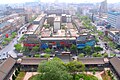 Aerial view of Yinchuan
 -
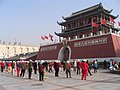 People's Square in Yinchuan
 -
 Fountain in Yinchuan
 -
 The 108 dagobas near Qingtongxia
 -
 Wolfberry harvest celebration


Notes
- ^ China archaeology and art digest, Volume 3, Issue 4. Art Text (HK) Ltd. 2000. p. 354. Retrieved 2010-11-28.
- ^ Close, U., and McCormick (1922) "Where the mountains walked" National Geographic Magazine 41(5): pp.445–464.
- ^ Feng, X. and Guo, A. (1985) "Earthquake landslides in China" In Proceedings, IVth International Conference and Field Workshop on Landslides pp. 339–346, Japan Landslide Society, Tokyo, OCLC 70324350.
- ^ Haines, Lester (19 July 2006)."Chinese black helicopters circle Google Earth". The Register
- ^ Cassidy, Katherine (13 September 2006). "Armchair Sleuths Uncover Strange Military Sites in China". McClatchy Newspapers / Real Cities Network.
- ^ Ningxia og Sogn og Fjordane eit steg vidare på samarbeidsvegen
- ^ http://thechinaperspective.com/topics/province/ningxia-hui-autonomous-region/
- ^ http://thechinaperspective.com/topics/province/ningxia-hui-autonomous-region/
- ^ http://thechinaperspective.com/topics/province/ningxia-hui-autonomous-region/
- ^ http://www.ycda.gov.cn - 银川经济技术开发区银川高新技术产业开发区
- ^ "Grape expansion: Chinese wine companies move west", Want China Times, 15 December 2011. Retrieved 17 December 2011.
- ^ http://www.chinaaid.org/2011/08/21-house-church-leaders-in-inner.html
References
- Economic profile for Ningxia at HKTDC
- Profile of Ningxia at china.org.cn
- Ningxia 2004 - The Year in Review
- Ningxia 2005 - The Year in Review
- Ningxia Profile - UNESCAP
- Ningxia Center for the Environment and Poverty Alleviation
- Ningxia Profile - China Economic Information Network
- Ningxia (autonomous region, China) -- Britannica Online Encyclopedia
External links
 Definitions from Wiktionary
 Media from Commons
 News from Wikinews
 Quotations from Wikiquote
 Texts from Wikisource
 Textbooks from Wikibooks
 Resources from Wikiversity
- Ningxia Provincial Government
- Ningxia Agricultural Information Network
- Ningxia Investment Promotion Bureau
- Britnannica Ningxia
- Template:Wikitravel
Places adjacent to Ningxia | ||||||||||||||||
|---|---|---|---|---|---|---|---|---|---|---|---|---|---|---|---|---|
| ||||||||||||||||