Pullenvale, Queensland
| Pullenvale Brisbane, Queensland | |||||||||||||||
|---|---|---|---|---|---|---|---|---|---|---|---|---|---|---|---|
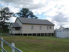
 Pullenvale Hall | |||||||||||||||
| Population | 3,154 (2006)[1] | ||||||||||||||
| • Density | 129.26/km2 (334.8/sq mi) | ||||||||||||||
| Postcode(s) | 4069 | ||||||||||||||
| Area | 24.4 km2 (9.4 sq mi) | ||||||||||||||
| LGA(s) | City of Brisbane (Pullenvale Ward) | ||||||||||||||
| State electorate(s) | Moggill | ||||||||||||||
| Federal division(s) | Ryan | ||||||||||||||
| |||||||||||||||
Pullenvale is situated approximately 15 km west of the Brisbane CBD of Queensland’s capital city. Pullenvale is named after early settler, Michael Pullen who in 1852 is said[by whom?] to have cleared a patch of dense bush around what is now Pullenvale with a single ox. Located in the southern foothills of Mount Elphinstone, Pullenvale features rolling hills and areas of bush land, and is spread over an area of approximately 24.4 square kilometres (9.4 sq mi).
Demographics
In the 2011 Census the population of Pullenvale is 3,174, 49.8% female and 50.2% male.
The median/average age of the Pullenvale population is 39 years of age, 2 years above the Australian average.
68.2% of people living in Pullenvale were born in Australia. The other top responses for country of birth were England 10.3%, South Africa 4.6%, New Zealand 2.4%, United States of America 1.4%, Scotland 1.1%.
91.2% of people speak English as their first language 1.1% Afrikaans, 0.7% German, 0.6% Japanese, 0.5% Mandarin, 0.4% Cantonese.
Landmarks
Pullenvale Hall, located at 302 Grandview Road, Pullenvale, is an old pineapple packing shed. The Hall was donated by resident Jack Woodward. It is the centre of many small functions and classes run by the residents of Pullenvale in cooperation with the Local Council.
Sporting clubs
Moggill Pony Club Inc. was formed in 1960. The land located at, 41 O'Brien Road, Pullenvale, is owned by the Pony Club.[2] The Pony Club is one of the oldest pony clubs in Queensland and covers four hectares of land.
Development
Pioneer Pullenvale residents developed a logging industry. The construction of Moggill Road, linking Brisbane with Ipswich via Moggill, made the area more accessible. Eventually the logging industry give way to small crop and dairy farming. The resulting tiny population of farming families led to the establishment of the Pullenvale State School in 1873. For the next 100 years or so the rural population remained steady, it was not until 1981 that the State School was rebuilt to cater for a great increase in population that stemmed from the encroaching Brisbane metropolis.
References
- ^ Australian Bureau of Statistics (25 October 2007). "Pullenvale (Statistical Local Area)". 2006 Census QuickStats. Retrieved 13 October 2007.
- ^ Moggill Pony Club Inc.. Retrieved 18 September 2010
External links
27°31′02″S 152°53′29″E / 27.5171°S 152.8914°E
