San Francisco, Cebu: Difference between revisions
Appearance
Content deleted Content added
No edit summary |
Carl Francis (talk | contribs) infobox |
||
| Line 1: | Line 1: | ||
{{Infobox settlement |
|||
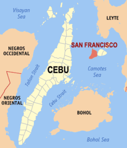
[[Image:Ph_locator_cebu_san francisco.png|right|Map of Cebu showing the location of San Francisco]] |
|||
| name = San Francisco, Cebu |
|||
| native_name = |
|||
| official_name = |
|||
| settlement_type = [[Cities of the Philippines|Municipality]] |
|||
| image_skyline = |
|||
| image_alt = |
|||
| image_caption = |
|||
| image_flag = |
|||
| flag_alt = |
|||
| image_seal = |
|||
| seal_alt = |
|||
| image_shield = |
|||
| shield_alt = |
|||
| nickname = |
|||
| motto = |
|||
| image_map = Ph_locator_cebu_san francisco.png |
|||
| map_alt = |
|||
| map_caption = |
|||
| pushpin_map = |
|||
| pushpin_label_position = |
|||
| pushpin_map_caption = |
|||
| latd = |
|||
| longd = |
|||
| coordinates_type = |
|||
| coordinates_display = |
|||
| coordinates_footnotes = |
|||
| subdivision_type = [[List of sovereign states|Country]] |
|||
| subdivision_name = {{flag|Philippines}} |
|||
| subdivision_type1 = [[Regions of the Philippines|Region]] |
|||
| subdivision_name1 = [[Central Visayas]] (Region VII) |
|||
| subdivision_type2 = [[Provinces of the Philippines|Province]] |
|||
| subdivision_name2 = [[Cebu Province|Cebu]] |
|||
| subdivision_type3 = [[House of Representatives of the Philippines#District representation|District]] |
|||
| subdivision_name3 = |
|||
| established_title = |
|||
| established_date = |
|||
| established_title1 = |
|||
| established_date1 = |
|||
| parts_type = [[Barangay]]s |
|||
| parts_style = coll |
|||
| p1 = |
|||
| leader_party = |
|||
| leader_title = [[Mayor]] |
|||
| leader_name = |
|||
| area_total_km2 = |
|||
| population_total = 44,588 |
|||
| population_as_of = 2007 |
|||
| population_density_km2 = auto |
|||
| elevation_m = |
|||
| blank_name_sec1 = |
|||
| blank_info_sec1 = |
|||
| timezone = [[Philippine Standard Time|PHT]] |
|||
| utc_offset = +8 |
|||
| postal_code_type = [[List of ZIP codes in the Philippines|ZIP Code]] |
|||
| postal_code = |
|||
| website = - |
|||
| footnotes = |
|||
}} |
|||
'''San Francisco''' is a 4th class [[Philippine municipality|municipality]] in the [[Philippine province|province]] of [[Cebu province|Cebu]], [[Philippines]]. According to the 2007 census, it has a population of 44,588 people. |
'''San Francisco''' is a 4th class [[Philippine municipality|municipality]] in the [[Philippine province|province]] of [[Cebu province|Cebu]], [[Philippines]]. According to the 2007 census, it has a population of 44,588 people. |
||
Revision as of 06:38, 10 September 2010
San Francisco, Cebu | |
|---|---|
 | |
| Country | |
| Region | Central Visayas (Region VII) |
| Province | Cebu |
| Population (2007) | |
| • Total | 44,588 |
| Time zone | UTC+8 (PHT) |
| Website | - |
San Francisco is a 4th class municipality in the province of Cebu, Philippines. According to the 2007 census, it has a population of 44,588 people.
Almost all of San Francisco is located on Pacijan Island. A part of Barangay Esperanza also includes Tulang Island in the north. Both the islands of Pacijan and Tulang are in the Camotes Islands group.
Barangays
San Francisco is administratively subdivided into 15 barangays.
- Montealegre
- Cabunga-an
- Campo
- Consuelo
- Esperanza
- Himensulan
- Northern Poblacion
- San Isidro
- Santa Cruz
- Santiago
- Sonog
- Southern Poblacion
- Unidos
- Union
- Western Poblacion
External links
