
Cheyenne, Wyoming: Difference between revisions
m language add-on |
|||
| Line 92: | Line 92: | ||
Cheyenne was named the top western town for 2008 by the [[True West Magazine]], in the January/February 2009 issue. |
Cheyenne was named the top western town for 2008 by the [[True West Magazine]], in the January/February 2009 issue. |
||
==Geography== |
|||
Cheyenne is located at {{coord|41|8|44|N|104|48|7|W|city}} (41.145548, -104.802042){{GR|1}}. Lying near the southeast corner of the state, it is one of the [[geographic centers of the United States|least centrally located]] state capitals in the nation (together with cities such as [[Carson City, Nevada]] and [[Juneau, Alaska]]). |
|||
According to the [[United States Census Bureau]], the city has a total area of 54.9 km² (21.2 mi²). 54.7 km² (21.1 mi²) of it is land and 0.2 km² (0.1 mi²) of it (0.38%) is water. |
|||
Cheyenne, like most of Wyoming is classified as [[semi-arid]]. |
|||
{| class="wikitable" "text-align:center;font-size:90%;"| |
|||
| colspan="13" style="text-align:center;font-size:120%;"|Monthly Normal and Record High and Low Temperatures |
|||
|- |
|||
! style="background: #E5AFAA; color: #000000" height="17" | Month |
|||
! style="background: #E5AFAA; color:#000000;" | Jan |
|||
! style="background: #E5AFAA; color:#000000;" | Feb |
|||
! style="background: #E5AFAA; color:#000000;" | Mar |
|||
! style="background: #E5AFAA; color:#000000;" | Apr |
|||
! style="background: #E5AFAA; color:#000000;" | May |
|||
! style="background: #E5AFAA; color:#000000;" | Jun |
|||
! style="background: #E5AFAA; color:#000000;" | Jul |
|||
! style="background: #E5AFAA; color:#000000;" | Aug |
|||
! style="background: #E5AFAA; color:#000000;" | Sep |
|||
! style="background: #E5AFAA; color:#000000;" | Oct |
|||
! style="background: #E5AFAA; color:#000000;" | Nov |
|||
! style="background: #E5AFAA; color:#000000;" | Dec |
|||
|- |
|||
! style="background: #E5AFAA; color:#000000;" height="16;" | Rec High |
|||
| style="text-align:center; background: #E8EAFA; color:#000000;" | {{convert|66|°F|°C|abbr=on}}<br>(19 °C) |
|||
| style="text-align:center; background: #E8EAFA; color:#000000;" | {{convert|71|°F|°C|abbr=on}}<br>(22 °C) |
|||
| style="text-align:center; background: #E8EAFA; color:#000000;" | {{convert|74|°F|°C|abbr=on}}<br>(23 °C) |
|||
| style="text-align:center; background: #E8EAFA; color:#000000;" | {{convert|83|°F|°C|abbr=on}}<br>(28 °C) |
|||
| style="text-align:center; background: #E8EAFA; color:#000000;" | {{convert|91|°F|°C|abbr=on}}<br>(33 °C) |
|||
| style="text-align:center; background: #E8EAFA; color:#000000;" | {{convert|100|°F|°C|abbr=on}}<br>(38 °C) |
|||
| style="text-align:center; background: #E8EAFA; color:#000000;" | {{convert|100|°F|°C|abbr=on}}<br>(38 °C) |
|||
| style="text-align:center; background: #E8EAFA; color:#000000;" | {{convert|96|°F|°C|abbr=on}}<br>(36 °C) |
|||
| style="text-align:center; background: #E8EAFA; color:#000000;" | {{convert|95|°F|°C|abbr=on}}<br>(35 °C) |
|||
| style="text-align:center; background: #E8EAFA; color:#000000;" | {{convert|83|°F|°C|abbr=on}}<br>(28 °C) |
|||
| style="text-align:center; background: #E8EAFA; color:#000000;" | {{convert|75|°F|°C|abbr=on}}<br>(24 °C) |
|||
| style="text-align:center; background: #E8EAFA; color:#000000;" | {{convert|69|°F|°C|abbr=on}}<br>(20 °C) |
|||
|- |
|||
! style="background: #E5AFAA; color:#000000;" height="16;" | Norm High |
|||
| style="text-align:center; background: #F8F3CA; color:#000000;" | {{convert|37|°F|°C|abbr=on}}<br>(3 °C) |
|||
| style="text-align:center; background: #F8F3CA; color:#000000;" | {{convert|41|°F|°C|abbr=on}}<br>(5 °C) |
|||
| style="text-align:center; background: #F8F3CA; color:#000000;" | {{convert|46|°F|°C|abbr=on}}<br>(8 °C) |
|||
| style="text-align:center; background: #F8F3CA; color:#000000;" | {{convert|54|°F|°C|abbr=on}}<br>(12 °C) |
|||
| style="text-align:center; background: #F8F3CA; color:#000000;" | {{convert|64|°F|°C|abbr=on}}<br>(18 °C) |
|||
| style="text-align:center; background: #F8F3CA; color:#000000;" | {{convert|75|°F|°C|abbr=on}}<br>(24 °C) |
|||
| style="text-align:center; background: #F8F3CA; color:#000000;" | {{convert|82|°F|°C|abbr=on}}<br>(28 °C) |
|||
| style="text-align:center; background: #F8F3CA; color:#000000;" | {{convert|80|°F|°C|abbr=on}}<br>(27 °C) |
|||
| style="text-align:center; background: #F8F3CA; color:#000000;" | {{convert|70|°F|°C|abbr=on}}<br>(21 °C) |
|||
| style="text-align:center; background: #F8F3CA; color:#000000;" | {{convert|58|°F|°C|abbr=on}}<br>(14 °C) |
|||
| style="text-align:center; background: #F8F3CA; color:#000000;" | {{convert|45|°F|°C|abbr=on}}<br>(7 °C) |
|||
| style="text-align:center; background: #F8F3CA; color:#000000;" | {{convert|38|°F|°C|abbr=on}}<br>(3 °C) |
|||
|- |
|||
! style="background: #E5AFAA; color:#000000;" height="16;" | Norm Low |
|||
| style="text-align:center; background: #C5DFE1; color:#000000;" | {{convert|15|°F|°C|abbr=on}}<br>(-9 °C) |
|||
| style="text-align:center; background: #C5DFE1; color:#000000;" | {{convert|17|°F|°C|abbr=on}}<br>(-8 °C) |
|||
| style="text-align:center; background: #C5DFE1; color:#000000;" | {{convert|22|°F|°C|abbr=on}}<br>(-6 °C) |
|||
| style="text-align:center; background: #C5DFE1; color:#000000;" | {{convert|29|°F|°C|abbr=on}}<br>(-2 °C) |
|||
| style="text-align:center; background: #C5DFE1; color:#000000;" | {{convert|38|°F|°C|abbr=on}}<br>(3 °C) |
|||
| style="text-align:center; background: #C5DFE1; color:#000000;" | {{convert|48|°F|°C|abbr=on}}<br>(9 °C) |
|||
| style="text-align:center; background: #C5DFE1; color:#000000;" | {{convert|53|°F|°C|abbr=on}}<br>(12 °C) |
|||
| style="text-align:center; background: #C5DFE1; color:#000000;" | {{convert|52|°F|°C|abbr=on}}<br>(11 °C) |
|||
| style="text-align:center; background: #C5DFE1; color:#000000;" | {{convert|43|°F|°C|abbr=on}}<br>(6 °C) |
|||
| style="text-align:center; background: #C5DFE1; color:#000000;" | {{convert|33|°F|°C|abbr=on}}<br>(1 °C) |
|||
| style="text-align:center; background: #C5DFE1; color:#000000;" | {{convert|22|°F|°C|abbr=on}}<br>(-6 °C) |
|||
| style="text-align:center; background: #C5DFE1; color:#000000;" | {{convert|16|°F|°C|abbr=on}}<br>(-9 °C) |
|||
|- |
|||
! style="background: #E5AFAA; color:#000000;" height="16;" | Rec Low |
|||
| style="text-align:center; background: #F8F3CA; color:#000000;" | {{convert|-30|°F|°C|abbr=on}}<br>(-34 °C) |
|||
| style="text-align:center; background: #F8F3CA; color:#000000;" | {{convert|-34|°F|°C|abbr=on}}<br>(-36 °C) |
|||
| style="text-align:center; background: #F8F3CA; color:#000000;" | {{convert|-21|°F|°C|abbr=on}}<br>(-29 °C) |
|||
| style="text-align:center; background: #F8F3CA; color:#000000;" | {{convert|-8|°F|°C|abbr=on}}<br>(-22 °C) |
|||
| style="text-align:center; background: #F8F3CA; color:#000000;" | {{convert|13|°F|°C|abbr=on}}<br>(-11 °C) |
|||
| style="text-align:center; background: #F8F3CA; color:#000000;" | {{convert|25|°F|°C|abbr=on}}<br>(-4 °C) |
|||
| style="text-align:center; background: #F8F3CA; color:#000000;" | {{convert|33|°F|°C|abbr=on}}<br>(1 °C) |
|||
| style="text-align:center; background: #F8F3CA; color:#000000;" | {{convert|36|°F|°C|abbr=on}}<br>(2 °C) |
|||
| style="text-align:center; background: #F8F3CA; color:#000000;" | {{convert|8|°F|°C|abbr=on}}<br>(-13 °C) |
|||
| style="text-align:center; background: #F8F3CA; color:#000000;" | {{convert|-1|°F|°C|abbr=on}}<br>(-18 °C) |
|||
| style="text-align:center; background: #F8F3CA; color:#000000;" | {{convert|-21|°F|°C|abbr=on}}<br>(-29 °C) |
|||
| style="text-align:center; background: #F8F3CA; color:#000000;" | {{convert|-28|°F|°C|abbr=on}}<br>(-33 °C) |
|||
|- |
|||
! style="background: #E5AFAA; color:#000000;" height="16;" | Precip |
|||
| style="text-align:center; background: #E8EAFA; color:#000000;" | {{convert|0.45|in|mm}} |
|||
| style="text-align:center; background: #E8EAFA; color:#000000;" | {{convert|0.44|in|mm}} |
|||
| style="text-align:center; background: #E8EAFA; color:#000000;" | {{convert|1.05|in|mm}} |
|||
| style="text-align:center; background: #E8EAFA; color:#000000;" | {{convert|1.55|in|mm}} |
|||
| style="text-align:center; background: #E8EAFA; color:#000000;" | {{convert|2.48|in|mm}} |
|||
| style="text-align:center; background: #E8EAFA; color:#000000;" | {{convert|2.12|in|mm}} |
|||
| style="text-align:center; background: #E8EAFA; color:#000000;" | {{convert|2.26|in|mm}} |
|||
| style="text-align:center; background: #E8EAFA; color:#000000;" | {{convert|1.82|in|mm}} |
|||
| style="text-align:center; background: #E8EAFA; color:#000000;" | {{convert|1.43|in|mm}} |
|||
| style="text-align:center; background: #E8EAFA; color:#000000;" | {{convert|0.75|in|mm}} |
|||
| style="text-align:center; background: #E8EAFA; color:#000000;" | {{convert|0.64|in|mm}} |
|||
| style="text-align:center; background: #E8EAFA; color:#000000;" | {{convert|0.56|in|mm}} |
|||
|- |
|||
| colspan="13" style="text-align:center;font-size:90%;"|''Source: Weather.com [http://www.weather.com/weather/wxclimatology/monthly/graph/USWY0032?from=search]'' |
|||
|} |
|||
==Demographics== |
==Demographics== |
||
Revision as of 20:14, 3 January 2009
This article needs additional citations for verification. (April 2008) |
City of Cheyenne, Wyoming | |
|---|---|
| Nickname(s): Magic City of the Plains; Capital City (of Wyoming); The Frontier City | |
 Location in Wyoming | |
| Country | United States |
| State | Wyoming |
| County | Laramie |
| Founded | 1867 |
| Government | |
| • Mayor | Jack R. Spiker |
| Area | |
| • City | 21.2 sq mi (57.9 km2) |
| • Land | 21.1 sq mi (54.7 km2) |
| • Water | 0.1 sq mi (0.2 km2) 0.38% |
| Elevation | 6,062 ft (1,848 m) |
| Population (2000) | |
| • City | 53,011 |
| • Density | 2,511.4/sq mi (969.6/km2) |
| • Metro | 81,607 |
| Time zone | UTC-7 (Mountain) |
| • Summer (DST) | UTC-6 (Mountain) |
| Area code | 307 |
| FIPS code | 56-13900Template:GR |
| GNIS feature ID | 1609077Template:GR |
| Website | www.cheyennecity.org |


Cheyenne (Template:Pron-en or Template:IPAlink-en) is the capital of the U.S. state of Wyoming. It is the principal city of the Cheyenne, Wyoming Cheyenne Metropolitan Statistical Area which encompasses all of Laramie County, Wyoming. The population was 53,011 at the 2000 census. It is the county seat of Laramie CountyTemplate:GR and the largest city in Wyoming.
History
On July 4, 1867, General Grenville M. Dodge and his survey crew platted the site now known as Cheyenne (Dakota Territory, later Wyoming Territory). There were many from a hundred miles around who felt the construction of the Union Pacific Railroad through the area would bring them prosperity. By the time the first track was built into Cheyenne four months later (November 13), over four thousand people had migrated into the new city. Because Cheyenne sprang up like magic, according to newspaper editors visiting from the East, it became known as "Magic City of the Plains" [citation needed].
Those who stayed and did not leave with the westward construction of the railroad were joined by gamblers, saloon owners, thieves, opportunists, prostitutes, displaced cowboys, miners, transient railroad gangs, proper business men, soldiers from "Camp Cheyenne," later named Fort D.A. Russell (now F.E. Warren Air Force Base), and men from Camp Carlin, a supply camp for fifteen [citation needed] northern army posts on the frontier.
The city was not named by Grenville Dodge as his memoirs state, but rather by his friends who accompanied him to the area Dodge called "Crow Creek Crossing." It was named for the Native American Cheyenne nation ("Shay-an"), one of the most famous and prominent Great Plains tribes closely allied with the Arapaho. The Cheyenne were among the fiercest fighters on the plains. Not pleased with the changes brought about by the railroad, they had harassed both railroad surveyors and construction crews.
As the capital of the Wyoming Territory and the only city of any consequence, as well as being the seat of the stockyards where cattle were loaded on the Union Pacific Railroad, the city's Cheyenne Club was the natural meeting place for the organization of the large well-capitalized ranches called the Wyoming Stock Growers Association. (See Johnson County War of 1892, the largest of the "range wars" of early Wyoming history). The newspaper offices of Asa Shinn Mercer's Northwestern Livestock Journal were burned down when the paper, which was founded as a public relations vehicle for the moneyed cattle interests, began to write scathing accounts of the events that were unfolding on the open range. His account is told in his book The Banditti of the Plains,.
As a town created by the railroad, Cheyenne fittingly preserves one of the eight surviving Union Pacific Big Boy locomotives ("4004"), some of the largest steam locomotives ever built, designed for hauling freight over the Rocky Mountains at high speeds. These engines typically hauled 100 freight cars up ruling grades between Cheyenne and Ogden, Utah, at 50 miles per hour. The locomotive now resides in Holliday park in central Cheyenne. The Union Pacific's last live-steam engines still reside in Cheyenne. The Challenger 3985 and the Northern 844, UP's last steam passenger engine, are maintained there. They are used for display and excursions across the county.
Alferd Packer, the only American ever convicted of cannibalism (though the official charge was murder since cannibalism is not a crime in the United States), was apprehended north of Fort Laramie and was taken to jail in Cheyenne, March 11, 1883.
Tom Horn, the notorious Pinkerton's agent who had been operating as a hit man for the Wyoming Stock Growers Association, was hanged in Cheyenne for a murder that he probably did not commit on November 20, 1903, the day before his 43rd birthday.
The Wyoming Telephone and Telegraph Company published the first telephone directory in the United States in Cheyenne in 1881. Due to a shortage of white paper, it was printed on yellow paper instead which started the tradition of the "yellow pages" phone directory[1].
Several ships of the United States Navy have been named USS Cheyenne in honor of this city as well as a couple of tug boats working around New York City [citation needed].
Bill O'Neal, a historian of the American West based in Carthage, Texas, published Cheyenne, 1867-1903': A Biography of the Magic City of the Plains in 2006.
Cheyenne was named the top western town for 2008 by the True West Magazine, in the January/February 2009 issue.
Demographics
| Census | Pop. | Note | %± |
|---|---|---|---|
| 1900 | 14,087 | — | |
| 1910 | 11,320 | −19.6% | |
| 1920 | 13,829 | 22.2% | |
| 1930 | 17,361 | 25.5% | |
| 1940 | 22,474 | 29.5% | |
| 1950 | 31,935 | 42.1% | |
| 1960 | 43,505 | 36.2% | |
| 1970 | 41,254 | −5.2% | |
| 1980 | 47,283 | 14.6% | |
| 1990 | 50,008 | 5.8% | |
| 2000 | 53,011 | 6.0% | |
| 2005 (est.) | 55,362 | ||
| State of Wyoming, U.S. Census Bureau | |||


As of the censusTemplate:GR of 2000, there were 53,011 people, 22,324 households, 14,175 families residing in the city, and 81,607 people residing in the Metropolitan Statistical Area making it the largest city and metropolitan area in the state of Wyoming. The population density was 969.6/km² (2,511.4/mi²). There were 23,782 housing units at an average density of 435.0/km² (1,126.7/mi²). The racial makeup of the city was 88.11% White, 2.78% Black or African American, 0.81% Native American, 1.06% Asian, 0.11% Pacific Islander, 4.44% from other races, and 2.69% from two or more races. 12.54% of the population were Hispanic or Latino of any race.
There were 22,324 households out of which 30.4% had children under the age of 18 living with them, 49.2% were married couples living together, 10.6% had a female householder with no husband present, and 36.5% were non-families. 31.3% of all households were made up of individuals and 10.6% had someone living alone who was 65 years of age or older. The average household size was 2.33 and the average family size was 2.93.
In the city the population was spread out with 24.9% under the age of 18, 8.8% from 18 to 24, 29.7% from 25 to 44, 22.8% from 45 to 64, and 13.8% who were 65 years of age or older. The median age was 37 years. For every 100 females there were 95.3 males. For every 100 females age 18 and over, there were 92.7 males.
The median income for a household in the city was $38,856, and the median income for a family was $46,771. Males had a median income of $32,286 versus $24,529 for females. The per capita income for the city was $19,809. About 6.3% of families and 8.8% of the population were below the poverty line, including 11.1% of those under age 18 and 5.8% of those age 65 or over.
Cheyenne Frontier Days
Cheyenne hosts the Cheyenne Frontier Days annually during the last week of July. Its rodeo is the largest outdoor rodeo in the world. It also includes a carnival, gunslingers, historic tours, and other features and events. More than 30,000 tourists come to Cheyenne for this event.
Landmarks
- Wyoming State Capitol
- Cheyenne Botanic Gardens
- F.E. Warren Air Force Base, one of the nation's oldest, continuously active installations with a United States Army - to - United States Air Force evolution.
- Nagle Warren Mansion
Historical places
Over fifty different locations in Cheyenne are listed on the National Register of Historical Places, including:
- the Atlas Theatre (added 1973)
- Union Pacific Depot (1973)
- the Governor's Mansion (1969)
- Nagle-Warren Mansion (1976)
- First United Methodist Church (1975)
- St. Mark's Episcopal Church (1970)
- St. Mary's Catholic Cathedral (1974)
- Cheyenne High School (2005)
- Storey Gymnasium (2005)
Several districts in the city are also listed, including:
- the Downtown District (1978, with boundary increase in 1980, 1988, 1996. Encompasses 205 acres (0.83 km2) and 67 buildings)
- Lakeview District (1996, 350 acres 109 buildings)
- Rainsford District (1984, 1980 acres 288 buildings)
- Capitol North District (1980, 204 acres 112 buildings)
- Fort David A. Russell (1969, 6300 acres 19 buildings)
- Union Pacific Roundhouse, Turntable and Machine Shop (1992, 113 acres 2 buildings)
- South Side District (2006)
Transportation
Highways
- North-South Interstate running from New Mexico to Wyoming intersects I-80 southwest of Cheyenne.
- East-West Interstate running from California to New York. Intersects I-25 southwest of Cheyenne.
- North-South interstate that runs concurrent with US 85 from I-80 to US 30.
(It is the only Interstate Highway that is not up to Interstate Highway standards along its entire route)
![]() US 30 (Lincolnway)
US 30 (Lincolnway)
- East-West route through Cheyenne
![]() US 85 (South Greely Hwy., Central Ave. (Southbound), Warren Ave. (Northbound))
US 85 (South Greely Hwy., Central Ave. (Southbound), Warren Ave. (Northbound))
- North-South route through Cheyenne
- North-South through Cheyenne that runs concurrent with I-25 through Cheyenne
![]() WYO 210 (Happy Jack Rd.)
WYO 210 (Happy Jack Rd.)
- East-West route from I-25/US 87 (Exit 10) west out of Cheyenne towards Laramie.
![]() WYO 212 (College Dr., Four Mile Rd.)
WYO 212 (College Dr., Four Mile Rd.)
- North-South route that forms a beltway around Cheyenne. From I-25 (Exit 7) to WYO 219.
![]() WYO 219 (Yellowstone Rd.)
WYO 219 (Yellowstone Rd.)
- North-South route from US 85 in Cheyenne near the Cheyenne Airport north out of the city
![]() WYO 221 (Fox Farm Rd.)
WYO 221 (Fox Farm Rd.)
- East-west route from US 85 east to WYO 212 in Cheyenne
![]() WYO 222 (Fort Access Rd.)
WYO 222 (Fort Access Rd.)
- North-South route from WYO 225 just southeast of Cheyenne and travels north to F.E. Warren Air Force Base and continues on its north route east of the city to WYO 221.
![]() WYO 225 (Otto Rd.)
WYO 225 (Otto Rd.)
- East-West route from I-80/US 30 southwest of Cheyenne west.
Airports
Cheyenne is serviced by Cheyenne Airport.
Railroads
Union Pacific and BNSF serve Cheyenne.
Fictional references to Cheyenne
In Philip K. Dick's alternative history novel The Man in the High Castle, Cheyenne is where Hawthorne Abendsen lives in his "High Castle".
In the American serial drama Jericho, Cheyenne is the capital city of the Allied States of America, a separatist faction of the United States formed after a surprise nuclear attack on the country's major metropolitan areas. The population has swelled to nearly a million. The March 18th, 2008 episode ended with a shot of the city's skyline, which had been built up with skyscrapers since the attack due to the surge in population and political importance.
In the 1984 motion picture Red Dawn, Cheyenne is the farthest north that the Mexican, Soviet, and Nicaraguan forces have pushed American forces, according to the downed Air Force pilot.
In the motion picture Ready to Rumble, the two main protagonists go to a live WCW Monday Night Nitro in Cheyenne.
In the hit song by Garth Brooks, "Beaches of Cheyenne", Cheyenne is the city in which a cowboy dies in a rodeo.
Sister Cities
Cheyenne's sister cities are:
Under Consideration:
Notable natives and residents
- James L. Applegate (born 1930) — Cheyenne attorney and former Democratic member of the Wyoming State Senate (1989-1997) and Minority Leader (1995-1996)
- Wallace R. Benson (1916-2008) - American prisoner of war in Italy during World War II and former head of the photogrammetry department of the Wyoming Highway Department
- John Godina (born 1972) — Shot putter; won a silver medal at the 1996 Atlanta Olympics and a bronze medal at the 2000 Sydney games. Godina was born in Oklahoma but attended Cheyenne Central High School.
- Curt Gowdy (1919-2006) — National sportscaster
- William T. Kane (1932-2008) — Physicist in field of fiber optics
- Cynthia Lummis (born 1954) — Former member of both houses of the Wyoming legislature and former Republican state treasurer (1999-2007); candidate for the United States House of Representatives, 2008
- John C. Ostlund (1927-2004) — Republican member of the Wyoming State Senate and 1978 gubernatorial nominee. Born in Gillette, Ostlund lived in Cheyenne the last decade of his life.
- Dean T. Prosser (1917-2007) — Republican member of the Wyoming House of Representatives from 1971-1983 and leader in environmental legislation
- Edward R. Prosser (born 1949) — Former Republican member of the Wyoming House of Representatives[citation needed]
- Robert Schliske (1924-2007) — Founding faculty member of Laramie County Community College and former Republican member of the Wyoming House of Representatives
- Dorothy Schwartz (1913-2007) — Violinist with the Cheyenne Symphony
- Joseph D. Selby (1950-2007) — Former Republican member of the Wyoming House of Representatives and municipal judge
- Larry D. Shippy (1946-2007) — Former Republican member of the Wyoming House of Representatives and official of Cheyenne Frontier Days rodeo
- Edwin H. Whitehead (1925-2007) — Former member of the Wyoming House of Representatives and leader of the John F. Kennedy forces in Wyoming in 1960
- Alvin Wiederspahn (born 1949) — Former Democratic member of both houses of the Wyoming legislature and prominent Cheyenne lawyer; husband of Cynthia Lummis
- Dan Zwonitzer (born 1979) — Republican member of the Wyoming House of Representatives
Media
- Wyoming Tribune-Eagle newspaper
References
- ^ "Welcome to Cheyenne, Wyoming". Retrieved 2008-02-10.
External links
Municipalities and communities of Laramie County, Wyoming, United States | ||
|---|---|---|
| City | 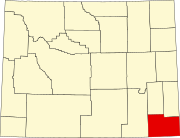 | |
| Towns | ||
| CDPs | ||
| Other communities | ||