
Sela Pass: Difference between revisions
Undid revision 559393952 by 220.227.139.188 (talk) see Legend section below |
|||
| Line 29: | Line 29: | ||
==Legend== |
==Legend== |
||
[[File:View of Jaswant Garh and NH - Tawang.JPG|thumb|250px|View of Jaswant Garh and NH - Tawang]] |
[[File:View of Jaswant Garh and NH - Tawang.JPG|thumb|250px|View of Jaswant Garh and NH - Tawang]] |
||
According to legend, a [[sepoy]] of the Indian Army named |
According to legend, a [[sepoy]] of the Indian Army named jaswant singh rawath fought alone against the Chinese soldiers near the pass during the 1962 [[Sino-Indian War]]. A tribal woman who had brought food and water to him is said to have killed herself upon seeing the dead body of Jaswant Singh rawath . Singh was posthumously awarded the [[Maha Vir Chakra]] for his courage.<ref name="arunachalonline.in" /><ref name="travelomy.com" /> |
||
==Gallery== |
==Gallery== |
||
Revision as of 11:10, 15 July 2013
| Sela Pass | |
|---|---|
| Se La | |
 Sela pass in April, 2007 | |
| Elevation | 4,170 metres (13,680 ft) |
| Location | Arunachal Pradesh, India |
| Range | Himalaya |

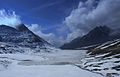
The Sela Pass (more appropriately called Se La, as La means Pass) is the world's highest motorable high-altitude mountain pass located in Tawang District of Arunachal Pradesh state of India. It has an elevation of 4170 m (13,700 ft).[1][2] connects the Buddhist city of Tawang Town to Tezpur and Guwahati and is the main road connecting Tawang with the rest of India. Tawang is situated at a distance of 78 km from Sela Pass while Guwahati is at a distance of 340 km.[3] The pass has hardly any vegetation and is usually snow covered to some extent all through the year.During winter temperature in the pass can go down to -10 degrees.[4]
This place is snowed in most of the year and offers excellent and heavenly views all year round. This part of the Eastern Himalayan range is pretty special for the Buddhists as it is believed that about 101 lakes exist in and around Sela pass and each of these lakes has a huge religious significance for the Buddhist community.[1] Very close to the Pass is the beautiful Sela Lake (sometimes called Paradise Lake because of its beauty), which could be fully or partially frozen in winter.[5] Some small rivers also flow out of the lake and during grazing season, yaks grazing around the lake.[2]
While Sela Pass does get heavy snow in winters, it is usually open throughout the year unless landslides or snow require the pass to be shut down temporarily. Sela Pass is the main route to access Tawang town, and given the proximity of Tawang District with Tibet.
Geography
Sela Pass is situated at a distance of 78 km from Tawang town. The pass is open throughout the year. During landslide and heavy snow the pass is shut down temporarily. Tawang district lies in close proximity to Tibet and is also the main rout to access Tawang.[4] Border Roads Organization (BRO) of India works hard to keep the pass open throughout the year. While summers at Sela Pass are not very cold, temperature in winter can dip down to -10 degree Celsius.[6]
Religion
Sela Pass is special to the Buddhists. The Buddhists believe that there are about 101 lakes in and around the pass. These lakes are revered to the Buddhists.[4]
Legend

According to legend, a sepoy of the Indian Army named jaswant singh rawath fought alone against the Chinese soldiers near the pass during the 1962 Sino-Indian War. A tribal woman who had brought food and water to him is said to have killed herself upon seeing the dead body of Jaswant Singh rawath . Singh was posthumously awarded the Maha Vir Chakra for his courage.[4][2]
Gallery
-
 Early morning fog
 -
 Clouds moving into the pass
 -
 Sela Pass


See Also
References
- ^ a b "High Altitude Sela Pass–Backbone of Tawang District". Sankara Subramanian C (www.beontheroad.com). beontheroad.com. JANUARY 21, 2011. Retrieved 2013-04-18.
{{cite web}}: Check date values in:|date=(help) - ^ a b c "Sela Passmountain pass". travelomy.com. Retrieved 2013-04-18.
- ^ "How To Reach Sela Pass". Travelomy. Retrieved 2011-06-19.
- ^ a b c d "Sela Pass". Pan India Internet Private Limited (PIIPL). arunachalonline.in. Retrieved 2013-04-19.
- ^ "Other Important Atractions of Tawang District". National Informatics Centre, Tawang (Arunachal Pradesh). Retrieved 2013-04-18.
- ^ "Sela Pass". Travelomy. Retrieved 2011-06-19.
External Links
This article about a location in the Indian state of Arunachal Pradesh is a stub. You can help Wikipedia by expanding it. |