Jackson Township, Fayette County, Indiana: Difference between revisions
Appearance
Content deleted Content added
Cut parent category; add photo |
Rescuing 1 sources and tagging 1 as dead. #IABot (v1.1) |
||
| Line 73: | Line 73: | ||
|area_code = |
|area_code = |
||
|blank_name = [[Federal Information Processing Standard|FIPS code]] |
|blank_name = [[Federal Information Processing Standard|FIPS code]] |
||
|blank_info = 18-36990<ref name="GR2">{{cite web|url=http://factfinder2.census.gov|publisher=[[United States Census Bureau]]|accessdate=2008-01-31|title=American FactFinder}}</ref> |
|blank_info = 18-36990<ref name="GR2">{{cite web|url=http://factfinder2.census.gov |publisher=[[United States Census Bureau]] |accessdate=2008-01-31 |title=American FactFinder |deadurl=yes |archiveurl=https://web.archive.org/web/20130911234518/http://factfinder2.census.gov |archivedate=September 11, 2013 }}</ref> |
||
|blank1_name = [[Geographic Names Information System|GNIS]] feature ID |
|blank1_name = [[Geographic Names Information System|GNIS]] feature ID |
||
|blank1_info = 453443 |
|blank1_info = 453443 |
||
| Line 114: | Line 114: | ||
==References== |
==References== |
||
* {{cite gnis|453443|Jackson Township, Fayette County, Indiana|2009-09-24}} |
* {{cite gnis|453443|Jackson Township, Fayette County, Indiana|2009-09-24}} |
||
* [http://www.census.gov/geo/www/cob/ United States Census Bureau cartographic boundary files] |
* [http://www.census.gov/geo/www/cob/ United States Census Bureau cartographic boundary files]{{dead link|date=July 2016 |bot=InternetArchiveBot |fix-attempted=yes }} |
||
<references/> |
<references/> |
||
Revision as of 15:54, 21 July 2016
Jackson Township | |
|---|---|
 Church in Everton | |
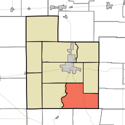
 Location of Jackson Township in Fayette County | |
| Country | United States |
| State | Indiana |
| County | Fayette |
| Government | |
| • Type | Indiana township |
| Area | |
| • Total | 27.39 sq mi (70.9 km2) |
| • Land | 27.39 sq mi (70.9 km2) |
| • Water | 0 sq mi (0 km2) |
| Elevation | 994 ft (303 m) |
| Population (2010) | |
| • Total | 1,524 |
| • Density | 55.6/sq mi (21.5/km2) |
| FIPS code | 18-36990[2] |
| GNIS feature ID | 453443 |
Jackson Township is one of nine townships in Fayette County, Indiana. As of the 2010 census, its population was 1,524 and it contained 615 housing units.[3]
History
Jackson Township was established in 1820 from land given by Columbia Township.[4] It was named for General and afterward President Andrew Jackson.[5]
Geography
According to the 2010 census, the township has a total area of 27.39 square miles (70.9 km2), all land.[3]
Unincorporated towns
Adjacent townships
- Jennings Township (northeast)
- Harmony Township, Union County (east)
- Blooming Grove Township, Franklin County (southeast)
- Laurel Township, Franklin County (southwest)
- Columbia Township (west)
- Connersville Township (northwest)
Major highways
Cemeteries
The township contains the following cemeteries: Maize Elliott Farm Cemetery, Everton Cemetery, Green Family Cemetery, Ireland Church Cemetery, Sarah and John Lee Farm Cemetery, Mt. Zion Cemetery, Myers-Brumfiel Cemetery, Old Parrot or Marvin Rose Cemetery, Poplar Ridge Cemetery, Union or Old Smallwood Cemetery
References
- "Jackson Township, Fayette County, Indiana". Geographic Names Information System. United States Geological Survey, United States Department of the Interior. Retrieved 2009-09-24.
- United States Census Bureau cartographic boundary files[permanent dead link]
- ^ "US Board on Geographic Names". United States Geological Survey. 2007-10-25. Retrieved 2008-01-31.
- ^ "American FactFinder". United States Census Bureau. Archived from the original on September 11, 2013. Retrieved 2008-01-31.
{{cite web}}: Unknown parameter|deadurl=ignored (|url-status=suggested) (help) - ^ a b "Population, Housing Units, Area, and Density: 2010 - County -- County Subdivision and Place -- 2010 Census Summary File 1". United States Census. Retrieved 2013-05-10.
- ^ History of Fayette County, Indiana. Warner, Beers and Company. 1885. p. 199.
- ^ Barrows, Frederic Irving (1917). History of Fayette County, Indiana: Her People, Industries and Institutions. Bowen, B. F. p. 242.

