
Salem, Oregon
Salem, Oregon | |
|---|---|
 | |
| Nickname: The Cherry City | |
| Location in Marion and Polk Counties, state of Oregon Location in Marion and Polk Counties, state of Oregon | |
| Country | United States |
| State | Oregon |
| Counties | Marion, Polk |
| Founded | 1842 |
| Government | |
| • Mayor | Janet Taylor |
| Area | |
| • City | 46.4 sq mi (120.1 km2) |
| • Land | 44.8 sq mi (118.4 km2) |
| • Water | 0.6 sq mi (1.6 km2) |
| Elevation | 154 ft (46.7 m) |
| Population (2006) | |
| • City | 149,305 |
| • Density | 2,994.0/sq mi (1,156.1/km2) |
| • Metro | 379,406 |
| (estimated) | |
| Time zone | UTC-8 (PST) |
| • Summer (DST) | UTC-7 (PDT) |
| Area code | 503 |
| FIPS code | 41-64900Template:GR |
| GNIS feature ID | 1167861Template:GR |
| Website | www.cityofsalem.net |
Salem (IPA: [ˈseɪ ləm̩]) is the capital of the U.S. state of Oregon, and the county seat of Marion County. The district of West Salem lies in Polk County. It is located in the mid-Willamette Valley, between Portland and Eugene. As of July 1 2006 it had a population of 149,305,[1] with a metro area population of nearly 400,000, making it the second largest city, and second largest metropolitan area in Oregon (after Portland).
"Salem" is derived from the Hebrew word "Shalom", and the Arabic word "Salam" both meaning "peace". Historically, Salem has been nicknamed the "Cherry City", because of the importance of the local cherry growing industry.[2]
History
The Native American name for the area was Chemeketa, which means "meeting or resting place" in the Santiam Kalapuya language. The word "Chemeketa" is preserved in the name of the local community college and other local buildings. The original Kalapuya pronunciation of the word is Chim-i-ki-ti.[3]
The first European settlement in the area was the Jason Lee mission in 1840. In 1842, the missionaries established the Oregon Institute (the forerunner of Willamette University) in the area that was to become the first townsite of Salem. In 1844, the mission was dissolved and the townsite established. According to Oregon Geographic Names, it is uncertain who chose the name for the town, but it is believed to be one of two people: Trustee David Leslie from Salem, Massachusetts, or William H. Willson who in 1850-1851 filed the plats for the main part of the city.
However, there is an interesting juxtaposition of meanings for this location of the words "salem" or "salam", Arabic for "peace", and the Kalapuyan word Chemeketa meaning "a place of rest".
In 1851, Salem became the territorial capital after it was moved from Oregon City. The capital was moved briefly to Corvallis in 1855, but was moved back to Salem permanently that same year. A two-story state house, which had been occupied for only two months, burned to the ground in December of 1855. Salem was incorporated as a city in 1857 and became Oregon's state capital with statehood two years later.
Oregon's second capitol building was completed in 1876 on the site of the original. The Greek revival-style building was based in part on the U.S. Capitol building. The building received its distinctive copper dome in 1893. Tragically, fire claimed the second Oregon capitol building on April 25, 1935.

The third and current Oregon State Capitol was completed on the same site in 1938. It is recognizable by its distinctive pioneer statue atop the capitol dome that is plated with gold-leaf and officially named the Oregon Pioneer.
The first cherry festival in Salem was held in 1903. In the following decades, the event briefly became an annual event, with parades and the election of a cherry queen, but was disbanded after World War I. It was revived briefly as the Salem Cherryland Festival for several years in the late 1940s.[4]
Geography and climate
Salem is located at 44°55′51″N 123°1′44″W / 44.93083°N 123.02889°WInvalid arguments have been passed to the {{#coordinates:}} function (44.931109, -123.029159).Template:GR
The 45th Parallel (halfway between the North Pole and the Equator) passes through Salem's city limits.
According to the United States Census Bureau, the city has a total area of 120.1 km² (46.4 mi²). 118.4 km² (45.7 mi²) of it is land and 1.6 km² (0.6 mi²) of it (1.35%) is water.
Although the Willamette River flows through Salem, the North Santiam River Watershed is Salem's primary drinking water source.
| Monthly Normal and Record High and Low Temperatures | ||||||||||||
| Month | Jan | Feb | Mar | Apr | May | Jun | Jul | Aug | Sep | Oct | Nov | Dec |
|---|---|---|---|---|---|---|---|---|---|---|---|---|
| Record High °C (°F) | 18.3 (65) | 22.2 (72) | 26.7 (80) | 31.1 (88) | 37.8 (100) | 40.6 (105) | 42.2 (108) | 42.2 (108) | 40.0 (104) | 33.9 (93) | 22.2 (72) | 20.0 (68) |
| Normal High °C (°F) | 8.3 (47.0) | 10.7 (51.2) | 13.5 (56.3) | 16.2 (61.1) | 19.7 (67.5) | 23.3 (74.0) | 27.5 (81.5) | 27.7 (81.9) | 24.8 (76.6) | 18.1 (64.5) | 11.3 (52.4) | 8.0 (46.4) |
| Normal Low °C (°F) | 0.8 (33.5) | 1.5 (34.7) | 2.6 (36.6) | 3.8 (38.8) | 6.4 (43.6) | 9.1 (48.4) | 11.1 (52.0) | 11.2 (52.1) | 8.7 (47.7) | 5.2 (41.3) | 3.3 (37.9) | 1.1 (33.9) |
| Record Low °C (°F) | -23.3 (-10) | -20.0 (-4) | -11.1 (12) | -5.0 (23) | -3.9 (25) | 0.0 (32) | 2.8 (37) | 2.2 (36) | -3.3 (26) | -6.7 (20) | -12.8 (9) | -24.4 (-12) |
| Normal Precipitation mm (inches) |
148.3 (5.84) |
129.3 (5.09) |
105.9 (4.17) |
70.1 (2.76) |
54.1 (2.13) |
36.8 (1.45) |
14.5 (0.57) |
17.3 (0.68) |
36.3 (1.43) |
77.0 (3.03) |
162.3 (6.39) |
164.1 (6.46) |
| Normal Snowfall mm (inches) | 73.7 (2.9) |
33.0 (1.3) |
12.7 (0.5) |
0.0 (0.0) |
T (T) |
0.0 (0.0) |
0.0 (0.0) |
0.0 (0.0) |
T (T) |
T (T) |
7.6 (0.3) |
40.6 (1.6) |
| Source:[5] | ||||||||||||
Neighborhoods
Salem has 19 established neighborhoods:[6]
Demographics
As of the censusTemplate:GR of 2006, there were 150,254 people, 50,676 households, and 32,331 families residing in the city. The population density was 1,156.1/km² (2,994.0/mi²). There were 53,817 housing units at an average density of 454.4/km² (1,176.8/mi²). The racial makeup of the city was 83.07% White, 1.28% African American, 1.51% Native American, 2.41% Asian, 0.47% Pacific Islander, 7.90% from other races, and 3.36% from two or more races. Hispanic or Latino of any race were 14.59% of the population.
There were 50,676 households out of which 32.4% had children under the age of 18 living with them, 47.7% were married couples living together, 11.6% had a female householder with no husband present, and 36.2% were non-families. 28.3% of all households were made up of individuals and 10.5% had someone living alone who was 65 years of age or older. The average household size was 2.53 and the average family size was 3.10.
In the city, the population was spread out with 25.4% under the age of 18, 11.4% from 18 to 24, 30.1% from 25 to 44, 20.6% from 45 to 64, and 12.4% who were 65 years of age or older. The median age was 34 years. For every 100 females, there were 100.9 males. For every 100 females age 18 and over, there were 99.5 males.
The median income for a household in the city was $38,881, and the median income for a family was $46,409. Males had a median income of $34,746 versus $26,789 for females. The per capita income for the city was $19,141. About 10.5% of families and 15.0% of the population were below the poverty line, including 20.2% of those under age 18 and 7.1% of those age 65 or over.
Economy
State government is Salem's largest employer, but the city also serves as a hub for the area farming communities and is a major agricultural food processing center.[7] It lies along the I-5 corridor and is within an hour's drive of Oregon's largest city, Portland.
In a bid to diversify its economic base, Salem attracted a number of computer-related manufacturing plants in the 1990s. In November 2003, the Sumitomo Mitsubishi Silicon Group (SUMCO), one of these arrivals, announced it would be closing its two silicon wafer plants at the end of 2004, eliminating 620 jobs, and moving production to other plants.[8] In June 2006, SUMCO announced that its last facility in the city, a technology center, would close by the end of the year.[9]
The top private employer in Salem is the Salem Hospital with over 2,700 employees. Others include the Confederated Tribes of the Grand Ronde's Spirit Mountain Casino west of Salem, the T-Mobile Calling Center, GE Security (Formerly Supra Products Inc.), Wachovia Securities, Norpac Foods Inc. and Roth's Family Markets. The largest public employer in Salem is the Department of Human Services, which employs over 4,000 people.[citation needed]
Salem is the headquarters of the Oregon Department of Corrections and home to four state correctional facilities, including the Oregon State Penitentiary, Oregon's only maximum security prison.
Numerous projects are underway to increase the supply of housing in the downtown core. These projects will provide upscale, low and high rise condominium and office space.
Arts and culture
Annual cultural events

From May through October the Salem Saturday Market, located north of the Capitol, exhibits an emphasis on local products including crafts, baked goods, produce, meat, and other items. In addition to the Saturday Market, there is a Wednesday Farmers' Market hosted downtown in Courthouse Square during the summer, as well a Holiday Gift Market in December. The 60+ year old, indoor Saturday Public Market is open all year round.
The annual World Beat Festival , held in June, is sponsored by the nonprofit Salem Multicultural Institute. The event lasts for two days and is held at the Riverfront Park. It features international crafts, music, dance, food, and folklore from every continent, and in recent years has held a Dragon Boat race similar to the ones held during the Rose Festival in Portland.
The Salem Art Association sponsors the annual Salem Art Fair & Festival, which takes place at Bush's Pasture Park during the summer. Its displays, interactive exhibits, food, and performances attract thousands of visitors each year, making it the largest juried art festival of its kind in the state.
The Bite of Salem, held in July at the Riverfront Park, is an event similar to others such as the Bite of Oregon in Portland. The event consists of a weekend of local restaurants in Salem offering samples of their menus to patrons in a festival atmosphere, with live entertainment and benefiting local charities. Mountain West Group Chef's Nite Out is an upscale wine and food benefit held for the Marion-Polk Food Share.
The largest event in Salem is the Oregon State Fair in late summer. Located in the Oregon State Fairgrounds in North Salem, the fair offers the usual exhibits, competitions and carnival atmosphere of a traditional state fair in addition to big-ticket concerts, wine tasting, and rock climning. Other events such as concerts, horse shows and rodeos take place at the Oregon State Fair and Expo Center throughout the year.
The Salem Repertory Theatre presents shows at the Reed Opera House. The rustic Pentacle Theatre, which features plays and musicals, is located in West Salem. The historic Elsinore Theatre is also a landmark featuring recitals, concerts, films, and plays.
The Nightmare Factory at the Oregon School for the Deaf, is oregon's longest running haunted attration. http://www.nightmarefactorysalem. All proceeds benifit the schools dorm programs.
Museums and other points of interest

In addition to the Oregon State Capitol building, and adjacent Willson Park, Salem's downtown contains the Mission Mill Museum, Hallie Ford Museum of Art, and the historic Elsinore Theatre. The tallest building in Salem, and the only one taller than the State Capitol building, is the First United Methodist Church.[1] The current sanctuary was completed in 1878. Its tall white spire rises at the intersection of Church and State Streets across from the Capitol grounds.
The Oregon Symphony, based in Portland, presents approximately ten classical and pops concerts each year in Salem. The Salem Chamber Orchestra includes professional area musicians as well as students.
The Salem Armory Auditorium has hosted touring bands including Korn and Phish.
Because Salem is the state capital, it has a multitude of government agencies, departments and boards housed in buildings with architecture designs ranging from the early 20th century to examples of state-of-the-art civil building design.
The historic Reed Opera House in downtown Salem has a number of local shops and dining establishments, as well as an art gallery.
Salem has been awarded "Tree City USA" status by the National Arbor Day Foundation for 30 consecutive years for its dedication to urban forestry.[10] Salem was the first city in Oregon to receive the award.[11] In keeping with the city's "Cherry City" theme, flowering cherry trees have been planted along many Salem streets as well as on the Capitol Mall across from the Capitol.
The Salem Public Library's main branch is located just south of downtown. A branch library is located in West Salem (Polk County). The Library participates in the Chemeketa Cooperative Regional Library Service, so Salem Public Library cards are also valid in of the member libraries in Yamhill, Polk, Marion, and parts of Linn County.
The film One Flew Over the Cuckoo's Nest was filmed at the Oregon State Hospital.
Sports
The Salem-Keizer Volcanoes, a minor league baseball team, play their home games in the city of Keizer, which adjoins Salem on the north.
The Salem Stampede of the International Basketball League play their home games at the Salem Armory.
Parks and recreation
Salem maintains 42 city parks. Minto-Brown Island Park is the largest at 898.9 acres (364 ha).[12] Bush's Pasture Park, a 90.5-acre (36.6-ha) urban park a few blocks south of downtown Salem, features natural groves of native Oregon White Oak trees, the historic Bush House, a rose garden, and adjacent Deepwood Estates.[13] Riverfront Park, adjacent to downtown, runs along the Willamette River and is the home of the Salem Carousel. The A.C. Gilbert House, located near Riverfront Park, has a toy museum and "discovery house" for children. Salem is also home to one of the smallest city parks in the world, Waldo Park, which consists of a single Sequoia tree.[14] (It used to be claimed that it was the smallest, but Mill Ends Park park in Portland is smaller.) Other notable parks are Willamette Mission State Park just north of the city, and Silver Falls State Parks just 30 minutes east near Silverton. Marion County also manages several parks within the city limits. Salem residents can easily enjoy nearby parks in Keizer as well as in the surrounding areas of Marion and Polk counties.
Education
Primary and secondary schools
Public
Alternative schools
- Chemawa Indian School - public Federal (Bureau of Indian Affairs) - Native American boarding high school
- Oregon School for the Blind - public State - elementary through high school
- Oregon School for the Deaf - public State - elementary through high school
- Winema School (formerly Chemeketa Alternative High) - public State - high school
Private
- Abiqua School - private secular - elementary and middle school
- Blanchet Catholic School - private Roman Catholic - middle and high school
- Concordia Lutheran School - private Lutheran Missouri Synod - elementary and middle school
- Cornerstone Christian School - private nondenominational - preschool and elementary
- Grace Academy - private nondenominational - elementary, middle, and high school
- The Heritage School - private secular - elementary and middle "alternative" school
- H.I.S. Academy - private nondenominational - elementary through high school
- Queen of Peace Catholic School - private Roman Catholic - elementary
- Riviera Christian School - private Baptist - preschool and elementary
- Salem Academy Christian Schools - private nondenominational - preschool to high school, multiple locations
- Sonshine School - private Baptist - preschool and elementary
- St. Joseph School - private Roman Catholic - elementary
- St. Vincent de Paul Catholic School - private Roman Catholic - preschool and elementary
- Western Mennonite School - private Mennonite - middle and high school
- Willamette Academy - private nonsectarian but historically United Methodist - high school supplementary
- Livingstone Adventist Academy - private Seventh-Day Adventist- Elementary, Middle and Highschool
Colleges and universities
- Chemeketa Community College - public - undergraduate
- Corban College - private Baptist - undergraduate
- Tokyo International University of America - private nonsectarian - undergraduate exchange
- Willamette University - private nonsectarian but historically United Methodist - undergraduate and graduate
Mass media
Newspaper
- The Statesman Journal, daily newspaper
- Salem Monthly, alternative newspaper
- The Capital Press, weekly agricultural paper with west coast distribution
Television
Internet
Transportation
Bus
Salem-Keizer Transit ("Cherriots"), an independent government agency, provides fixed-route bus service, rideshare matching, and paratransit/lift services for the disabled, within the urban growth boundary.
Greyhound Lines provides north-south service and connecting carrier service to Bend, Oregon from its station downtown.
Rail
Amtrak, the national passenger rail system, leases the Salem Depot from the Oregon Department of Transportation. The Coast Starlight provides daily north-south service to cities between Los Angeles, California and Seattle, Washington. Amtrak Cascades trains, operating as far north as Vancouver, British Columbia and as far south as Eugene, Oregon, serve Salem several times daily in both directions.
Air
HUT Airport Shuttle provides transportation to Portland International Airport. HUT also serves Corvallis with a second stop at Oregon State University, Albany, and Woodburn.
McNary Field (Salem Municipal Airport) is owned and operated by the City of Salem. It serves primarily private aviation and the Oregon National Guard - Army Aviation Support Facility (AASF). Delta Connection offers commercial air service with two daily flights to Salt Lake City, Utah. The airport is planning to perform terminal improvements using a preconstructed modular building.[16]
Highways
The city is served by the following highways:
- Interstate 5
- Oregon Route 99E
- Oregon Route 99E Business is a spur of the above, serving the downtown area
- Oregon Route 22
- Oregon Route 221
- Oregon Route 51
- Oregon Route 213
Gallery
-
 The Salem skyline.
 -
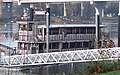 The Willamette Queen paddleboat on the Willamette River.
 -
The carousel in Riverfront Park.
-
 Riverfront Park in downtown.
 -
First United Methodist Church in downtown.
-
 Marion County courthouse, located downtown.
 -
 Wisteria covered alley in downtown Salem.
 -
 A neighborhood in South Salem covered in snow.


Sister cities
Salem has two sister cities:[17]
Further reading
- MacGibbon, Elma (1904). Leaves of knowledge. Shaw & Borden Co.
{{cite book}}: External link in|title=
References
- ^ Portland State University (2006-12-15). "PRC Certified Cities 2006" (PDF). Retrieved 2007-08-05.
{{cite web}}: Check date values in:|date=(help); Cite has empty unknown parameters:|month=and|coauthors=(help) - ^ Lucas,Bill. "The Cherry City". Retrieved 2007-08-05.
- ^ Johnson, Tony, Language Education Supervisor, CTGR Cultural Resources Division
- ^ Hermann,Shirley. "Salem's Cherry Festival". Retrieved 2007-08-05.
- ^ "Salem Weather Data". USTravelWeather.com. Retrieved 2007-08-05.
- ^ "Find Your Neighborhood". City of Salem. Retrieved 2007-08-05.
- ^ "About Salem,Oregon". Retrieved 2007-08-05.
- ^ "Statement from SUMCO on the closure". Statesman Journal. November 13, 2003. Retrieved 2007-03-30.
{{cite web}}: Check date values in:|date=(help) - ^ The Statesman Journal. June 2, 2006
- ^ "Tree Cities in Oregon". The National Arbor Day Foundation. Retrieved 2007-08-05.
- ^ "Salem, Oregon-Tree City USA". City of Salem. 1977-03-25. Retrieved 2007-08-05.
{{cite web}}: Check date values in:|date=(help) - ^ "Minto Brown Island Park". City of Salem. Retrieved 2007-08-05.
- ^ "Bushs Pasture Park". City of Salem. Retrieved 2007-08-05.
- ^ "Waldo Park". City of Salem. Retrieved 2007-08-05.
- ^ http://www.Salem-News.com
- ^
"Delta to begin two daily flights from Salem to Salt Lake City". Statesman Journal. February 26 2007. Retrieved 2007-03-25.
{{cite web}}: Check date values in:|date=(help); Cite has empty unknown parameter:|coauthors=(help) - ^ "City of Salem.net". Retrieved 2007-09-17.
External links
- City of Salem
- Salem Online History
- Official Salem, Oregon tourism site
- The Salem Chamber of Commerce
- Oregon Blue Book entry for Salem