
Jackson County, Alabama
Jackson County | |
|---|---|
 Jackson County courthouse in Scottsboro, Alabama | |
 Location within the U.S. state of Alabama | |
 Alabama's location within the U.S. | |
| Coordinates: 34°47′00″N 86°00′00″W / 34.783333333333°N 86°W | |
| Country | |
| State | |
| Founded | December 13, 1819 |
| Seat | Scottsboro |
| Largest city | Scottsboro |
| Area | |
| • Total | 1,127 sq mi (2,920 km2) |
| • Land | 1,079 sq mi (2,790 km2) |
| • Water | 48 sq mi (120 km2) 4.26% |
| Population (2000) | |
| • Total | 53,926 |
| • Density | 22/sq mi (9/km2) |
Jackson County is a county of the U.S. state of Alabama, and is included in the Huntsville-Decatur Metro Area. Its name is in honor of Andrew Jackson, general in the United States Army and President of the United States of America. As of 2000, the population was 53,926. Its county seat is Scottsboro and it's a prohibition or dry county. However, three cities within the county (Bridgeport, Scottsboro, and Stevenson) are wet. Jackson County covers parts of former Decatur County.
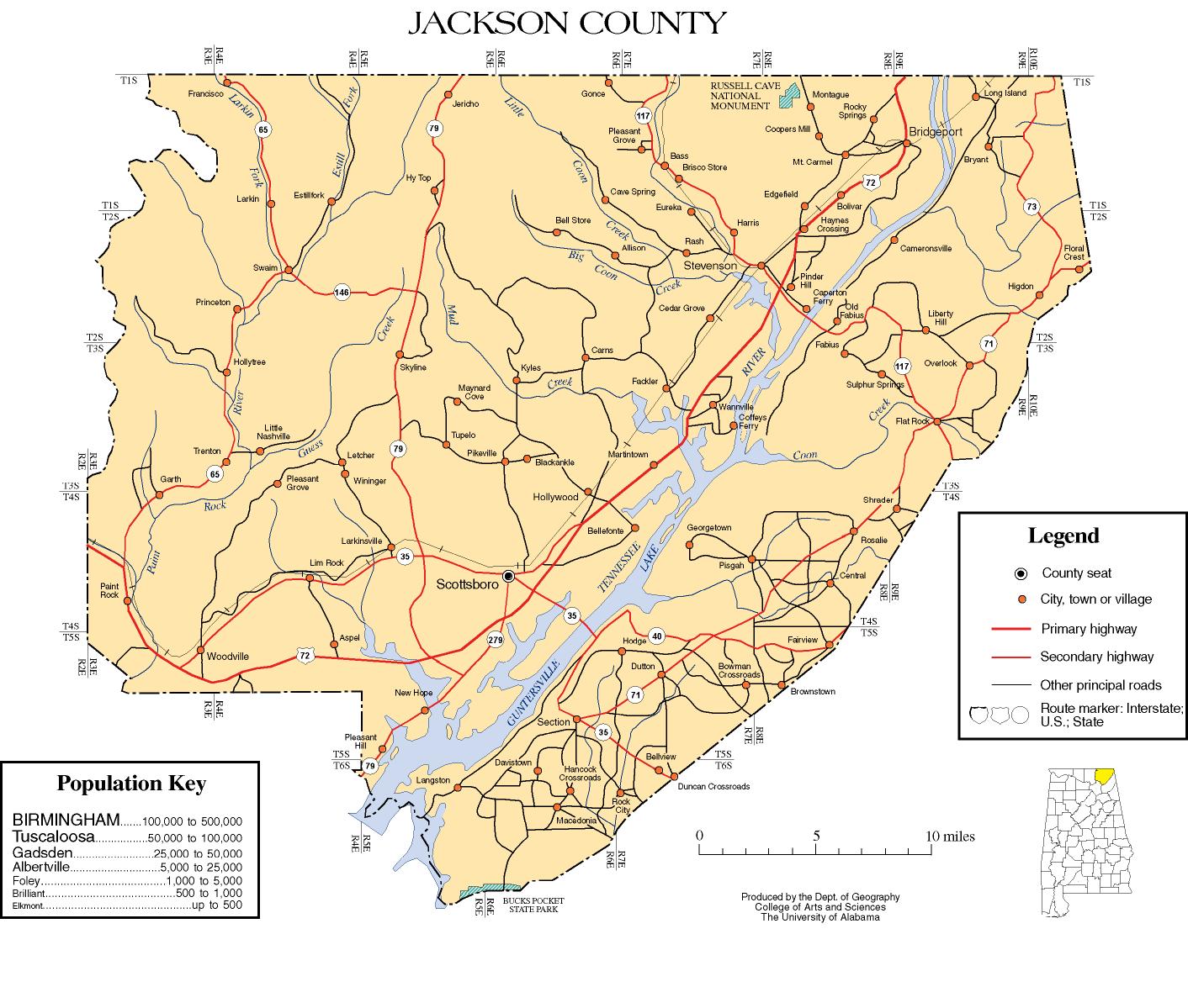
Map

History
Jackson County was established on December 13, 1819.
Politics
While most of North Alabama has become solidly Republican, Jackson County remains a strong-hold of the Democratic Party (which is not to say the residents are liberals; see Dixiecrat and Southern Democrat). There are no elected Republicans in local Jackson County Government. In the, 2004 Presidential Election, Jackson County voted for Republican George W. Bush over Democrat John Kerry. It was the first time Jackson County voters chose a Republican presidential candidate over a Democrat since 1972.
Geography
According to the U.S. Census Bureau, the county has a total area of 2,918 km² (1,127 square miles). Nearly 1,079 square miles (2,794 km²) of it is land, and 48 square miles (124 km²) of it (4.26%) is water. Much of it is located in the Appalachians.
Of special interest is Russell Cave National Monument, which is located in Doran Cove, approximately 5 miles west of the town of Bridgeport. Russell Cave is an important archaeological site that was excavated in 1956 by the Smithsonian Institution and the National Geographic Society. An article in the October 1956 issue of National Geographic Magazine proudly proclaims: "Life 8,000 Years Ago Uncovered in an Alabama Cave." The article was written by Carl F. Miller, the Expedition Leader and is on pages 542-558. Russell Cave was declared a National Monument in May 1961 by President John F. Kennedy. The Monument consists of 310 acres (1.3 km2) of land donated by the National Geographic Society.
Major highways
 U.S. Highway 72
 State Route 35
 State Route 40
 State Route 65
 State Route 71
 State Route 73
 State Route 75
 State Route 79
 State Route 279
Rail
Adjacent counties
- Marion County, Tennessee - northeast
- Dade County, Georgia - east
- DeKalb County, Alabama - southeast
- Marshall County, Alabama - southwest
- Madison County, Alabama - west
- Franklin County, Tennessee - northwest
Places adjacent to Jackson County, Alabama | ||||||||||||||||
|---|---|---|---|---|---|---|---|---|---|---|---|---|---|---|---|---|
| ||||||||||||||||
National protected areas
- Fern Cave National Wildlife Refuge
- Russell Cave National Monument
- Sauta Cave National Wildlife Refuge
Demographics
As of the censusTemplate:GR of 2000, there were 53,926 people, 21,615 households, and 15,822 families residing in the county. The population density was 50 people per square mile (19/km²). There were 24,168 housing units at an average density of 22 per square mile (9/km²). The racial makeup of the county was 91.89% White, 3.74% Black or African American, 1.75% Native American, 0.23% Asian, 0.02% Pacific Islander, 0.36% from other races, and 2.00% from two or more races. Nearly 1.13% of the population were Hispanic or Latino of any race.
There were 21,615 households, out of which 31.50% had children under the age of 18 living with them, 59.00% were married couples living together, 10.50% had a female householder with no husband present, and 26.80% were non-families. Nearly 24.30% of all households were made up of individuals, and 10.50% had someone living alone who was 65 years of age or older. The average household size was 2.47, and the average family size was 2.92.
In the county, the population was spread out with 24.20% under the age of 18, 8.30% from 18 to 24, 28.70% from 25 to 44, 25.40% from 45 to 64, and 13.40% who were 65 years of age or older. The median age was 38 years. For every 100 females, there were 95.10 males. For every 100 females age 18 and over, there were 92.00 males.
The median income for a household in the county was $32,020, and the median income for a family was $38,082. Males had a median income of $29,777 versus $20,990 for females. The per capita income for the county was $16,000. About 10.30% of families and 13.70% of the population were below the poverty line, including 17.20% of those under age 18 and 21.00% of those age 65 or over.
Cities and towns
- Bridgeport
- Bryant
- Dutton
- Flat Rock
- Higdon
- Hollywood
- Hytop
- Langston
- Paint Rock
- Pisgah
- Pleasant Groves
- Scottsboro
- Section
- Skyline
- Stevenson
- Woodville
References
External links
- www.jacksoncountyal.com
- Jackson County Historical Society
- Jackson County Chamber of Commerce
- Jackson County map of roads/towns (map © 2007 Univ. of Alabama).
Template:Huntsville-Decatur Metropolitan Area
Municipalities and communities of Jackson County, Alabama, United States | ||
|---|---|---|
| Cities |  | |
| Towns | ||
| Unincorporated communities | ||
| Ghost towns | ||