
Deccan Plateau

The Deccan Plateau, also known as the Peninsular Plateau or the Great Peninsular Plateau,[1] is a large plateau in India, making up the majority of the southern part of the country, ranging in elevation from 100 metres in the north to 1000 metres in the south. It is located between three mountain ranges and extends over eight Indian states. Its uplands make up a triangle nested within the familiar downward-pointing triangle of the Indian sub-continent's coastline.[2] It encompasses a wide range of habitats, covering most of central and southern India.[3] The Western Ghats form its western boundary, and the Eastern Ghats its eastern boundary. Each rises from their respective nearby coastal plains and nearly meet at the southern tip of India. These two ranges form the southward-pointing vertex of a triangle which encompasses the plateau with the roughly west-south-west to east-north-east running Satpura Range and Vindhya Range forming the third northern boundary of the region. The northern ranges separate the plateau from the heavily populated riverine plains of northern India. Large areas of the states of Maharashtra and Karnataka and parts of Andhra Pradesh comprise the Deccan plateau.
The name Deccan is an anglicised form of the Prakrit word dakkhin, itself derived from the Sanskrit word dákṣiṇa, meaning "south".[4]
Geography


The Deccan Plateau lies south of the Indo-Gangetic plain. The Western Ghats Mountain Range is tall and blocks the moisture from the southwest monsoon from reaching the Deccan Plateau, so the region receives very little rainfall.[5][6] The eastern Deccan Plateau is at a lower elevation spanning the southeastern coast of India. Its forests are also relatively dry but serve to retain the rain to form streams that feed into rivers that flow into basins and then into the Bay of Bengal.[2][7]
The Godavari River and its tributaries, including the Indravati River, drain most of the northern portion of the plateau, rising in the Western Ghats and flowing east towards the Bay of Bengal. The Tungabhadra River, Krishna River and its tributaries, including the Bhima River, which also run from west to east, drain the central portion of the plateau. The southernmost portion of the plateau is drained by the Kaveri River, which rises in the Western Ghats of Karnataka and bends south to break through the Nilgiri Hills at Hogenakal Falls into Tamil Nadu, then forming the Sivasamudram Falls at the island town of Shivanasamudra, the second-biggest waterfall in India and the sixteenth-largest in the world,[8] before flowing into the Stanley Reservoir and the Mettur Dam that created the reservoir and finally emptying into the Bay of Bengal. The two rivers that do not flow into the Bay Of Bengal are Narmada and Tapi. They start in the Eastern Ghats and flow into the Arabian sea.
The rivers of the Himalayas are snow-fed and so perennial throughout the year. But the rivers of the Deccan Plateau depend on the rains and so they dry up in the summers.Template:Left66 The climate of the region varies from subtropical in the extreme north to tropical in most of the region with distinct wet and dry seasons. Rains falls during the wet or monsoon season from about June to October. March to June can be very dry and hot with temperatures exceeding 40°C regularly.
Geology
The vast volcanic basalt beds of the Deccan were laid down in the massive Deccan Traps eruption, which occurred towards the end of the Cretaceous period, between 67 and 65 million years ago. Some paleontologists speculate that this eruption may have accelerated the extinction of the dinosaurs. Layer after layer was formed by the volcanic activity that lasted many thousands of years, and when the volcanoes became extinct, they left a region of highlands with typically vast stretches of flat areas on top like a table. Hence it is also known as Table Top. The volcanic hotspot that produced the Deccan traps is hypothesized to lie under the present day island of Réunion in the Indian Ocean.
Typically the Deccan Plateau is made up of basalt extending up to Bhor Ghat near Karjat. This is an extrusive igneous rock. Also in certain sections of the region, we can find granite, which is an intrusive igneous rock. The difference between these two rock types is: basalt rock forms on eruption of lava, that is, on the surface (either out of a volcano, or through massive fissures -- as in the Deccan basalts -- in the ground), while granite forms deep within the Earth. Granite is a felsic rock, meaning it is rich in potassium feldspar and quartz. This composition is continental in origin (meaning it is the primary composition of the continental crust). Since it cooled relatively slowly, it has large visible crystals. Basalt, on the other hand, is mafic in composition -- meaning it is rich in pyroxene and, in some cases, olivine, both of which are Mg-Fe rich minerals. Basalt is similar in composition to mantle rocks, indicating that it came from the mantle and did not mix with continental rocks. Basalt forms in areas that are spreading, whereas granite forms mostly in areas that are colliding. Since both rocks are found in the Deccan Plateau, it indicates two different environments of formation.
The Deccan is rich in minerals. Primary mineral ores found in this region are mica and iron ore in the Chhota Nagpur region, and diamonds, gold and other metals in the Golconda region.
People
The Deccan is home to many languages and people. Bhil and Gond people live in the hills along the northern and northeastern edges of the plateau, and speak various languages that belong to both the Indo-European and Dravidian families of languages. Marathi, an Indo-Aryan language, is the main language of the north-western portion of the Deccan plateau. Speakers of Telugu and Kannada, the predominant languages of Andhra Pradesh and Karnataka respectively, occupy those states' portions of the plateau. Tamil is the main language of the state to the south of the plateau, and Malayalam that of the hills and coast to the south-west. The city of Hyderabad is an important centre of Urdu language in the Deccan; its surrounding areas also host a notable population of Urdu speakers. The Urdu dialect spoken in this region is also known as Dakhni or Deccani.
The chief crop is cotton, however, sugarcane, rice, and other crops are also common.
Several Indian states cover parts of the Deccan: Maharashtra covers most of the northern plateau, and Chhattisgarh the northeast corner. Andhra Pradesh covers the east-central portion of the Deccan, and Karnataka the west-central and most of the southern portion of the plateau, with the southernmost portion in Tamil Nadu. The largest city in the Deccan is Hyderabad, the capital of Andhra Pradesh. Other major cities include Bangalore (in Karnataka), Pune, Nagpur, Aurangabad (in Maharashtra).
History
The detailed and authentic history of the Deccan only begins with the 13th century A.D. Of the early history the main facts established are the growth of the Maurya empire (250 B.C.) and the invasion (A.D. 100) of the Scythic tribes known as the Sakas, Pahlavas and Yavanas, which led to the establishment of the power of the Kshaharata satraps in western India.
In 1294 Ala-ud-Din Khilji, emperor of Delhi, invaded the Deccan, stormed Devagiri, and reduced the Yadava rajas of Maharashtra to the position of tributary princes (see Daulatabad), then proceeding southward overran Telangana and Carnatic. With this event the continuous history of the Deccan begins. In 1307, owing to non-payment of tribute, a fresh series of Muslim incursions began, under Malik Kafur, issuing in the final ruin of the Yadava power; and in 1338 the reduction of the Deccan was completed by Sultan Muhammad bin Tughluq. The imperial hegemony was of brief duration as soon Telingana and Karnataka speedily reverted to their former masters and these defections by the Hindu states was soon followed by a general revolt of the Muslim governors, resulting in the establishment in 1347 of the independent Muslim dynasty of Bahmani, and the consequent withdrawal of the power of Delhi from the territory south of the Narmada River.
In the power struggles which ensued, the Hindu kingdom of Telingana fell bit by bit to the Bahamani dynasty, who advanced their frontier to Golkonda in 1373, to Warangal in 1421, and to the Bay of Bengal in 1472. On the dissolution of the Bahmani empire in 1482, its dominions were distributed into the five Muslim states of Golkonda, Bijapur, Ahmednagar, Bidar and Berar. To the south of these the Hindu state of Carnatic or Vijayanagar still survived; but this, too, was destroyed, at the Battle of Talikota (1565) by a league of the Muslim powers. Berar had already been annexed by Ahmednagar in 1572, and Bidar was absorbed by Bijapur in 1609. Ahmadnagar was partially incorporated in the Mughal Empire in 1598 and again in 1616, Bijapur in 1686, and Golkonda in 1688.
In 1674, Shivaji laid the foundation of the Maratha Empire which within 75 years of his death covered the western coast and most of central India. Marathas under Shivaji challenged the foreign rule of the Bijapur Sultanate and ultimately the mighty Mughal empire. They resisted incursions into their region by the Mughal rulers of most of India. Under their leader Shivaji Maharaj, the Marathas defeated the Muslim sultans of Bijapur to the southeast, and became much more aggressive and began to frequently raid Mughal territory. The Marathas had conquered some part of central and western India by Shivaji's death in 1680. After Shivaji, Sambhaji defended the Maratha empire from the Mughal onslaught led by Aurangzeb. Sambhaji didn't let Aurangzeb gain a single major victory before he was deceitfully captured and executed. After Rajaram and Tarabai, Peshwas began commanding Maratha armies. After 1707, the Marathas acquired the right of levying tribute in southern India. After the death of Chhatrapati Shahu, the Peshwas became the de facto leaders of the Empire from 1749 to 1761, while Shivaji's successors continued as nominal rulers from their base in Satara. . They oversaw the greatest expansion of the Maratha Empire around 1760 with the help of Sardars (Generals) like Holkar, Scindia (Shinde), Bhosale, Pantprainidhi, Gaekwad, Panse, Vinchurkar, Pethe, Raste, Phadke, Patwardhan, Pawar, Pandit and Purandare. However, dissension between the Peshwa and their sardars (army commanders) saw a gradual downfall of the empire leading to its eventual annexation by the British East India Company in 1818 after the three Anglo-Maratha wars.
A few years later the Aurangzeb's viceroy in Ahmednagar, Nizam-ul-Mulk, established the seat of an independent government at Hyderabad in 1724. Mysore was under Hyder Ali. During the contests for power which ensued about the middle of the 18th century between the native chiefs, the French and the British took opposite sides. After a brief course of triumph, the interests of France declined, and a new empire in India was established by the British. Mysore formed one of their earliest conquests in the Deccan. Tanjore and the Carnatic were shortly after annexed to their dominions. In 1818 the forfeited possessions of the Peshwa added to their extent; and these acquisitions, with others which have more recently fallen to the paramount power by cession, conquest, or failure of heirs, form a continuous territory stretching from the Narmada to Cape Comorin (Kanyakumari). This vast tract was divided by the British between the presidencies of Madras and Bombay, together with the native states of Hyderabad and Mysore, and those of Kolhapur, Sawantwari, Travancore, Cochin, and the petty possessions of France and Portugal. (EB 1911)
-
 Deccan style
 -
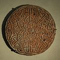 Calligraphic emblem of sculpted sandstone - 16th century
 -
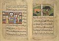 Nimmatnama-i Nasiruddin-Shahi (the Book of Recipes)


See also
- Geography of India
- South India, which includes Deccan.
- Mysore Plateau
- Vijayanagara Empire
- Kakatiya empire
- Bayaluseemae
Notes
- ^ Page 46, Dr. Jadoan, Atar Singh (Published September 2001). Military Geography of South-East Asia. India: Anmol Publications Pvt. Ltd. pp. 270 pages. ISBN 8126110082. Retrieved 2008-06-08.
{{cite book}}: Check date values in:|date=(help) - ^ a b "The Deccan Peninsula". sanctuaryasia. Retrieved 2007-01-05.
- ^ "The Deccan Plateau". rainwaterharvesting.org. Retrieved 2007-01-05.
- ^ Monier-Williams Sanskrit-English Dictionary, p. 498 (scanned image at SriPedia Initiative): Sanskrit dakṣiṇa meaning 'right', 'southern'.
- ^ "South Deccan Plateau dry deciduous forests d(IM0209)". nationalgeographic.com atul atul atul. Retrieved 2007-01-05.
- ^ "South Deccan Plateau dry deciduous forests (IM0209)". worldwildlife.org. Retrieved 2007-01-05.
- ^ "Eastern Deccan Plateau Moist Forests". World Wildlife Fund. Retrieved 2007-01-05.
- ^ "Shivasamudram Falls". Retrieved 2006-11-11.
References
- This article incorporates text from a publication now in the public domain: Chisholm, Hugh, ed. (1911). Encyclopædia Britannica (11th ed.). Cambridge University Press.
{{cite encyclopedia}}: Missing or empty|title=(help)
External links
- Photos of Deccan Plateau
- Dynasties of Deccan
- The Deccan Peninsula
- Central Deccan Plateau dry deciduous forests
- Geology of Deccan Plateau
- Deccan South Indian Online
| Branches |
| ||||||||
|---|---|---|---|---|---|---|---|---|---|
| Techniques and tools |
| ||||||||
| Institutions | |||||||||
| Education | |||||||||
 | ||