
Gerrymandering
| Part of the Politics series |
| Elections |
|---|
.svg) |
|
|
Gerrymandering is a form of boundary delimitation (redistricting) in which electoral district or constituency boundaries are deliberately modified for electoral purposes, thereby producing a contorted or unusual shape. The resulting district is known as a gerrymander; however, that noun can also refer to the process.
Gerrymandering may be used to achieve desired electoral results for a particular party, or may be used to help or hinder a particular group of constituents, such as a political, racial, linguistic, religious or class group.
When used to allege that a given party is gaining a disproportionate power, the term gerrymandering has negative connotations. However, a gerrymander may also be used for purposes that some perceive as positive, notably in US federal voting district boundaries which produce a proportion of constituencies with an African-American or other minority in the majority (these are thus called "minority-majority districts").
Origin of the term

The word gerrymander was coined by a newspaper editor in reaction to a redrawing of Massachusetts electoral boundaries under the then governor Elbridge Gerry (pronounced /ˈɡɛri/; 1744–1814), that included one sprawling supposedly salamander-shaped constituency.
In 1812, Governor Gerry signed a bill into law that redistricted his state to benefit his Democratic-Republican party. One of the resulting contorted districts was said to resemble a salamander.[1] The term first appeared in the Boston Centinel on March 26, 1812.
Although the letter g of the eponymous Gerry is pronounced /ɡ/ as in go, the word gerrymander is most commonly pronounced /ˈdʒɛrɪˌmændər/, with a /dʒ/ as in gentle.
Voting systems
Gerrymandering is used most often in favor of ruling incumbents[2] or a specific political party. Societies whose legislatures use a single-winner voting system are the most likely to have political parties that gerrymander for advantage.[citation needed] Most notably, gerrymandering is particularly effective in non-proportional systems that tend towards fewer parties, such as first past the post.
Most democracies have partly proportional electoral systems, where several political parties are proportionally represented in the national parliaments, in proportion to the total numbers of votes of the parties in the regional or national elections. In these more or less proportional representation systems, gerrymandering has little or less significance.
Some countries, such as the UK and Canada, authorize non-partisan organizations to set constituency boundaries in an attempt to prevent gerrymandering. Gerrymandering is most common in countries where elected politicians are responsible for defining constituency boundaries. They have obvious self interest in determining boundaries to their and their party's interest.
Gerrymandering should not be confused with malapportionment, whereby the number of eligible voters per elected representative can vary widely. Nevertheless the ~mander suffix has been applied to particular malapportionments, such as the "Playmander" in South Australia and the "Bjelkemander" in Queensland. Sometimes political representatives use both gerrymandering and malapportionment to try to maintain power.
Packing and cracking
The two aims of gerrymandering are to maximize the effect of supporters' votes and to minimize the effect of opponents' votes. One strategy, packing, is to concentrate as many voters of one type into a single electoral district to reduce their influence in other districts. In some cases this may be done to obtain representation for a community of common interest, rather than to dilute that interest over several districts to a point of ineffectiveness. A second strategy, cracking, involves spreading out voters of a particular type among many districts in order to deny them a sufficiently large voting block in any particular district. The strategies are typically combined, creating a few "forfeit" seats for packed voters of one type in order to secure even greater representation for voters of another type.
Gerrymandering is effective because of the wasted vote effect. By packing opposition voters into districts they will already win (increasing excess votes for winners) and by cracking the remainder among districts where they are moved into the minority (increasing votes for eventual losers), the number of wasted votes among the opposition can be maximized. Similarly, with supporters holding narrow margins in the unpacked districts, the number of wasted votes among supporters is minimized.
While the wasted vote effect is strongest when a party wins by narrow margins across multiple districts, gerrymandering narrow margins can be risky when voters are less predictable. To minimize the risk of demographic or political shifts swinging a district to the opposition, politicians can instead create more packed districts, leading to more comfortable margins in unpacked ones.
-
-
An example of the packing style of districting: California's 23rd congressional district.
-
An example of "cracking" style of gerrymandering. The urban (and mostly liberal) concentration of Columbus, Ohio, located at the center of the map in Franklin County, is split into thirds, each segment then attached to—and outnumbered by—largely conservative suburbs.
-
 California's 11th congressional district drawn to favor its then-Republican incumbent.
 -
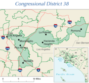 Bi-partisan incumbent gerrymandering produced California District 38, home to Grace Napolitano, a Democrat, who ran unopposed in 2004.
 -
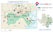 Texas' controversial 2003 partisan gerrymander produced Texas District 22 for former Rep. Tom DeLay, a Republican.
 -
 The odd shapes of California Senate districts in Southern California (2008) have led to claims of gerrymandering.
 -
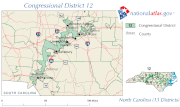
 The earmuff shape of Illinois's 4th congressional district connects two Hispanic areas while remaining contiguous by narrowly tracing Interstate 294.
 -
 Utah's 2nd congressional district was redrawn after the election of Democrat Jim Matheson in 2000 to favor future Republican majorities. The predominantly Democratic city of Salt Lake was connected to predominantly Republican eastern and southern Utah through a thin sliver of land running through Utah County. This particular redistricting did not have the desired effect, as Matheson has been re-elected twice.


Effects of gerrymandering

Reduction in electoral competition and voter turnout
The most immediate and obvious effect of gerrymandering is that elections become less competitive in all districts, particularly packed ones. As electoral margins of victory become significantly greater and politicians have safe seats, the incentive for meaningful campaigning is reduced.
As the chance of influencing electoral results by voting is reduced, voter turnout is likely to decrease. Correspondingly, political campaigns are less likely to expend resources to encourage turnout. With a reduction in competition, a candidate puts more effort into securing party nomination for a given district rather than gaining approval of the general electorate. In a gerrymandered district, the candidate is virtually assured of a win once nominated. In 2004, for example, when California's 3rd Congressional District became an open seat after Republican Congressman Doug Ose ran for higher office, the state's three strongest Republican congressional candidates campaigned vigorously against one another for nomination in the district's primary election. Several other districts were uncontested with no Republican nominees making even a token campaign effort.
Increased incumbent advantage and campaign costs
The effect of gerrymandering for incumbents is particularly advantageous, as incumbents are far more likely to be reelected under conditions of gerrymandering. For example, in 2002, according to political scientists Norman Ornstein and Thomas Mann, only four challengers were able to defeat incumbent members of the US Congress, the lowest number in modern American history.[3] Incumbents are likely to be of the majority party orchestrating a gerrymander, and incumbents are usually easily renominated in subsequent elections, including incumbents among the minority.
This demonstrates that gerrymandering can have a deleterious effect on the principle of democratic accountability. With uncompetitive seats/districts reducing the fear that incumbent politicians may lose office, they have less incentive to represent the interests of their constituents, even when those interests conform to majority support for an issue across the electorate as a whole. Incumbent politicians may look out more for their party's interests than for those of their constituents.
Gerrymandering can have an impact on campaign costs for district elections. If districts become increasingly stretched out, candidates must pay increased costs for transportation and trying to develop and present campaign advertising across a district.[citation needed] The incumbent's advantage in securing campaign funds is another benefit of his or her having a gerrymandered secure seat.
Less descriptive representation
Gerrymandering also has significant effects on the representation received by voters in gerrymandered districts. Because gerrymandering is designed to increase the number of wasted votes among the electorate, the relative representation of particular groups can be drastically altered from their actual share of the voting population. This effect can significantly prevent a gerrymandered system from achieving proportional and descriptive representation, as the winners of elections are increasingly determined by who is drawing the districts rather than the preferences of the voters.
Gerrymandering may be advocated to improve representation within the legislature among otherwise underrepresented minority groups by packing them into a single district. This can be controversial, as it may lead to those groups' remaining marginalized in the government as they become confined to a single district. Candidates outside that district no longer need to represent them to win election.
As an example, much of the redistricting conducted in the United States in the early 1990s involved the intentional creation of additional "majority-minority" districts where racial minorities such as African Americans were packed into the majority. This "maximization policy" drew support by both the Republican Party (who had limited support among African Americans and could concentrate their power elsewhere) and by minority representatives elected as Democrats from these constituencies, who then had safe seats.
Incumbent gerrymandering
Gerrymandering can also be done to help incumbents as a whole, effectively turning every district into a packed one and greatly reducing the potential for competitive elections. This is particularly likely to occur when the minority party has significant obstruction power—unable to enact a partisan gerrymander, the legislature instead agrees on ensuring their own mutual reelection.
In an unusual occurrence in 2000, for example, the two dominant parties in the state of California cooperatively redrew both state and Federal legislative districts to preserve the status quo, ensuring the electoral safety of the politicians from unpredictable voting by the electorate. This move proved completely effective, as no State or Federal legislative office changed party in the 2004 election, although 53 congressional, 20 state senate, and 80 state assembly seats were potentially at risk.
In 2006, the term "70/30 District" came to signify the equitable split of two evenly split (i.e. 50/50) districts. The resulting districts gave each party a guaranteed seat and retained their respective power base.
Prison-based gerrymandering
Prison-based gerrymandering occurs when prisoners are counted as residents of a particular district increasing the district's population with non-voters when assigning political apportionment. This phenomenon, according to prisoners' rights organization, violates the principle of one person, one vote. Prison Policy Initiative argues that although many prisoners come from (and return to) urban communities, they are counted as "residents" of the rural districts that contain large prisons, diluting urban voters' political clout and artificially inflating the political representation for rural districts.[4] Others contend that prisoners should not be counted as residents of their original districts when they neither reside there nor are legally eligible to vote.
Changes to achieve competitive elections
Due to many issues associated with gerrymandering and its impact on competitive elections and democratic accountability, numerous countries have enacted reforms making the practice either more difficult or less effective. Countries such as the UK, Australia, Canada and most of those in Europe have transferred responsibility for defining constituency boundaries to neutral or cross-party bodies.
In the United States, however, such reforms are controversial and frequently meet particularly strong opposition from groups that benefit from gerrymandering. In a more neutral system, they might lose considerable influence.
Redistricting by neutral or cross-party agency
The most commonly advocated electoral reform proposal targeted at gerrymandering is to change the redistricting process. Under these proposals, an independent and presumably objective commission is created specifically for redistricting, rather than having the legislature do it. This is the system used in the United Kingdom, where the independent Boundary Commission determines the boundaries for constituencies in the House of Commons and regional legislatures, subject to ratification by the body in question (almost always granted without debate).
To help ensure neutrality, members of a redistricting agency may be appointed from relatively apolitical sources such as retired judges or longstanding members of the civil service, possibly with requirements for adequate representation among competing political parties. Additionally, members of the board can be denied access to information that might aid in gerrymandering, such as the demographic makeup or voting patterns of the population. As a further constraint, consensus requirements can be imposed to ensure that the resulting district map reflects a wider perception of fairness, such as a requirement for a supermajority approval of the commission for any district proposal. Consensus requirements, however, can lead to deadlock, such as occurred in Missouri following the 2000 census. There, the equally numbered partisan appointees were unable to reach consensus in a reasonable time, and consequently the courts had to determine district lines.
In the US state of Iowa, the nonpartisan Legislative Services Bureau (LSB, akin to the US Congressional Research Service) determines boundaries of electoral districts. Aside from satisfying federally mandated contiguity and population equality criteria, the LSB mandates unity of counties and cities. Consideration of political factors such as location of incumbents, previous boundary locations, and political party proportions is specifically forbidden. Since Iowa's counties are chiefly regularly shaped polygons, the LSB process has led to districts that follow county lines.[3]
In 2005, the US state of Ohio had a ballot measure to create an independent commission whose first priority was competitive districts, a sort of "reverse gerrymander". A complex mathematical formula was to be used to determine the competitiveness of a district. The measure failed voter approval chiefly due to voter concerns that communities of interest would be broken up.[5]
Changing the voting system
Because gerrymandering relies on the wasted vote effect, the use of a different voting system with fewer wasted votes can help reduce gerrymandering. In particular, the use of multimember districts alongside voting systems establishing proportional representation such as single non-transferable vote or cumulative voting can greatly reduce the proportion of wasted votes, and therefore the potential for gerrymandering. Due to their relative simplicity and similarity to first past the post[citation needed] electoral reformers often advocate them as replacement systems[citation needed].
Electoral systems with different forms of proportional representation are now found in nearly all European countries. In this way, they have multi-party systems (with many parties represented in the parliaments) with higher voter attendance in the elections[citation needed], fewer wasted votes, and a wider variety of political opinions represented.
Electoral systems with election of just one winner in each district (i.e., "winner-take-all" electoral systems), and no proportional distribution of extra mandates to smaller parties, tend to create two-party systems (Duverger's Law). In these, just two parties effectively compete in the national elections and thus the national political discussions are forced into a narrow two-party frame, where loyalty and forced statements inside the two parties distort the political debate.
Changing the size of districts and the elected body
If a proportional or semi-proportional voting system is used then increasing the number of winners in any given district will reduce the number of wasted votes. This can be accomplished both by merging separate districts together and by increasing the total size of the body to be elected. Since gerrymandering relies on exploiting the wasted vote effect, increasing the number of winners per district can reduce the potential for gerrymandering in proportional systems. Unless all districts are merged, however, this method cannot eliminate gerrymandering entirely.
In contrast to proportional methods, if a nonproportional voting system with multiple winners (such as block voting) is used, then increasing the size of the elected body while keeping the number of districts constant will not reduce the amount of wasted votes, leaving the potential for gerrymandering the same. While merging districts together under such a system can reduce the potential for gerrymandering, doing so also amplifies the tendency of block voting to produce landslide victories, creating a similar effect to gerrymandering by concentrating wasted votes among the opposition and denying them representation.
If a system of single-winner elections is used, then increasing the size of the elected body will implicitly increase the number of districts to be created. This change can actually make gerrymandering easier when raising the number of single-winner elections, as opposition groups can be more efficiently packed into smaller districts without accidentally including supporters, further increasing the number of wasted votes amongst the opposition.
Using fixed districts
Another way to avoid gerrymandering is simply to stop redistricting altogether and use existing political boundaries such as state, county, or provincial lines. While this prevents future gerrymandering, any existing advantage may become deeply ingrained. The United States Senate, for instance, has more competitive elections than the House of Representatives due to the use of existing state borders rather than gerrymandered districts—Senators are elected by their entire state, while Representatives are elected in legislatively drawn districts.
The use of fixed districts creates an additional problem, however, in that fixed districts do not take into account changes in population. Individual voters can come to have very different degrees of influence on the legislative process. This malapportionment can greatly affect representation after long periods of time or large population movements. In the United Kingdom during the Industrial Revolution, several constituencies which had been fixed since they gained representation in the Parliament of England became so small that they could be won with only a handful of voters (rotten boroughs). Similarly, in the US the state legislature of Alabama refused to redistrict for more than 60 years, despite major changes in population patterns. By 1960 less than a quarter of the state's population controlled the majority of seats in the legislature.[6] However, this practice of using fixed districts for state legislatures was effectively banned in the United States after the Baker v. Carr Supreme Court decision, establishing a rule of one man, one vote.
Objective rules to create districts
Another means to reduce gerrymandering is to create objective, precise criteria to which any district map must comply. Courts in the United States, for instance, have ruled that congressional districts must be contiguous in order to be constitutional.[7] This, however, is not a particularly binding constraint, as very narrow strips of land with few or no voters in them may be used to connect separate regions for inclusion in one district.
Other proposed rules are based on mathematical properties of district geometry. Enforcing a maximum isoperimetric quotient, for instance, would encourage districts with a high ratio between area and perimeter.[8] However, rules based on boundary geometry may conflict with other desires for districts, such as including complete geographic features or adhering to the boundaries of existing local governments. Even if these constraints are taken into account, gerrymandering could still occur by exploiting remaining flexibility in the rules or by careful selection of the rules themselves.
- See also: Compactness measure of a shape
Use of databases and computer technology
The introduction of modern computers alongside the development of elaborate voter databases and special districting software has made gerrymandering a far more precise science. Using such databases, political parties can obtain detailed information about every household including political party registration, previous campaign donations, and the number of times residents voted in previous elections and combine it with other predictors of voting behavior such as age, income, race, or education level. With this data, gerrymandering politicians can predict the voting behavior of each potential district with an astonishing degree of precision, leaving little chance for creating an accidentally competitive district.
National examples of gerrymandering
Among western democracies, Israel and the Netherlands employ electoral systems with only one (nationwide) voting district for election of national representatives. This precludes gerrymandering.
Canada
Early in Canadian history, both the federal and provincial levels used gerrymandering to try to maximize partisan power. When Alberta and Saskatchewan were admitted to Confederation in 1905, their original district boundaries were set forth in the respective Alberta and Saskatchewan Acts. These boundaries had been devised by federal Liberal cabinet members to ensure the election of provincial Liberal governments.
Since responsibility for drawing federal and provincial electoral boundaries was handed over to independent agencies, this problem has largely been eliminated at these levels of government. Manitoba was the first province to authorize a non-partisan group to define constituency boundaries in the 1950s. In 1964, the federal government delegated the drawing of boundaries for national seats to the "arm's length" Elections Canada.
As a result, gerrymandering is not generally a major issue in Canada except at the civic level. Although city wards are recommended by independent agencies, city councils occasionally overrule them. This is much more likely where the city is not homogenous and different neighbourhoods have sharply different opinions about city policy direction.
In 2006, a controversy arose on Prince Edward Island over the provincial government's decision to throw out an electoral map drawn by an independent commission. Instead they created two new maps. The government adopted the second of these, designed by the caucus of the governing party. Opposition parties and the media attacked Premier Pat Binns for what they saw as gerrymandering of districts. Among other things, the government adopted a map that ensured that every current Member of the Legislative Assembly from the premier's party had a district to run in for re-election, whereas in the original map, several had been redistricted.[9] Despite this, in the 2007 provincial election only seven of 20 incumbent Members of the Legislative Assembly were re-elected (seven did not run for re-election).
The current federal electoral district boundaries in Saskatchewan have also been labelled as gerrymandered—the province's two major cities, Saskatoon and Regina, are both "cracked" into four districts each when the populations of the cities proper would justify about three and two and a half all-urban (or mostly urban) districts respectively[10] – the map instead groups parts of the New Democratic Party-friendly cities with large Conservative-leaning rural areas.[11]
At the time the districts were created in their largely present form in the mid-1990s, it was alleged that they were intended to give the NDP and Liberals a better chance of winning additional seats that included large sections of the province's rural hinterlands at the expense of the then-extant Reform Party. If that was the intention, it backfired – in 1997 Reform won three of the four Saskatoon seats despite their failure to earn a plurality of the city vote in any of the three ridings. In 2000 their successors the Canadian Alliance added the remaining Saskatoon seat plus one in Regina, and in 2004 the CA's successors the Conservatives added the NDP's two remaining Regina seats to shut the NDP out of the province. Since then the Conservatives have held the seven districts in question, while the NDP holds no seats in the province despite commanding a strong proportion of the vote especially in the cities. Polling data shows the Tories could probably not have swept either of these cities had they contained all-urban or mostly urban constituencies. Perhaps not surprisingly, neither the federal Conservatives nor the new centre-right Saskatchewan Party government has expressed any interest in changing the map, notwithstanding the fact that it was not their creation.
Chile
After Chileans voted General Augusto Pinochet out of power in a 1988 plebiscite, the military government began working on a law to define the new electoral system for the 1989 elections. The 60 electoral districts for the Chamber of Deputies (lower house) were designed so that—if the results of the 1988 plebiscite were extrapolated to the coming parliamentary elections—in no district would the NO option outpoll the YES option by more than two to one. (The NO option was for removing Pinochet from power and to trigger democratic elections.) The rationale for this—in a system in which only two candidates are elected per district and where a coalition needed twice the vote of the opponent to gain both district seats—was that the voters who favoured the NO option would vote for the Centre-Left coalition, which opposed the Pinochet dictatorship, and the ones that favoured the YES option would be inclined to vote for the candidates of the right, which supported the military government.
In the Senate —where a whole administrative region consists of one or two constituencies— gerrymandering of districts had a limited effect. The dictatorship, therefore, to ensure that the winning majority (the Center-Left coalition, as it was expected) would be unable to reach the quorum necessary to change the Constitution by itself, allocated a number of seats to appointed senators.[12] These unelected senators were eliminated in the 2005 constitutional reforms, but the electoral map has remained largely untouched. (In 2007 a new region was created, which altered the composition of two senatorial constituencies. The first election to be affected by this slight change takes place in 2013.)
Germany
When the electoral districts in Germany were redrawn in 2000, the ruling Social Democratic Party (SPD) was accused of gerrymandering to marginalize the socialist PDS party. The SPD combined traditional PDS strongholds in eastern Berlin with new districts made up of more populous areas of western Berlin, where the PDS had very limited following.
After having won four seats in Berlin in the 1998 national election, the PDS was able to retain only two seats altogether in the 2002 elections. Under German electoral law, a political party has to win either more than five percent of the votes, or at least three directly elected seats, to qualify for top-up seats under the Additional Member System. The PDS vote fell below five percent thus they failed to qualify for top-up seats and were confined to just two members of the Bundestag, the German federal parliament (elected representatives are always allowed to hold their seats as individuals). Had they won a third constituency, the PDS would have gained at least 25 additional seats, which would have been enough to hold the balance of power in the Bundestag.
In the election of 2005, the "Left Party" (successor of the PDS) gained 8.7% of the votes and thus qualified for top-up seats.
However, the number of Bundestag seats of parties which traditionally get over 5% of the votes cannot be affected very much by gerrymandering, because seats are awarded to these parties on a proportional basis. Only when a party wins so many districts in any one of the 16 federal states that those seats alone count for more than its proportional share of the vote in that same state does the districting have some influence on larger parties—those extra seats, called "Überhangmandate", remain.
Greece
Gerrymandering has been rather common in Greek history since organised parties with national ballots only appeared after the 1926 Constitution. The only case before that was the creation of the Piraeus electoral district in 1906, in order to give the Theotokis party a safe district. The most infamous case of gerrymandering was in the 1956 elections, which was incidentally the first election where women voted. While in all other post World War II national elections the districts were based on the prefecture (νομός) for 1956 the country was split in districts of varying sizes, others being the size of prefectures, others the size of sub-prefectures (επαρχία) and others somewhere in between. In small districts the winning party would take all seats, in intermediate size it would take most and there was proportional representation in the largest districts. The districts though were chosen in such a way that small districts were those that traditionally voted for the right while large districts were those that voted against the right. This system has become known as the three-phase (τριφασικό) system or the baklava system (because, as baklava is split into full pieces and corner pieces, the country was also split into disproportionate pieces). The opposition, being composed of the center and the left, formed a coalition with the sole intent to change the electoral law to be more representative and call new elections, despite the fact that only seven years earlier the center and the left had fought each other in the Greek Civil War. Despite the opposition winning the popular vote (1,620,007 votes against 1,594,992), the right wing ERE won the majority of seats (165 to 135) and was to lead the country for the next two years.
Ireland
Until the 1980s Dáil boundaries in the state of Ireland were drawn not by an independent commission but by government ministers. Successive arrangements by governments of all political characters have been attacked as gerrymandering. Ireland uses the Single Transferable Vote and as well as the actual boundaries drawn the main tool of gerrymandering has been the number of seats per constituency used, with three-seat constituencies normally benefiting the strongest parties in an area, whereas four-seat constituencies normally helped the second strongest party.
In 1947 the rapid rise of new party Clann na Poblachta threatened the position of the governing party Fianna Fáil. The government of Éamon de Valera introduced the Electoral Amendment Act, 1947 which increased the size of the Dáil from 138 to 147 and increased the number of three-seat constituencies from fifteen to twenty-two. The result has been described as "a blatant attempt at gerrymander which no Six County Unionist could have bettered."[13] The following February the 1948 general election was held and Clann na Poblachta secured ten constituencies instead of the nineteen they would have received proportional to their vote.[13]
In the mid-1970s, the Minister for Local Government, James Tully, attempted to arrange the constituencies to ensure that the governing Fine Gael–Labour Party National Coalition would win a parliamentary majority. The Electoral (Amendment) Act 1974 was planned as a major reversal of previous gerrymandering by Fianna Fáil (then in opposition). Tully ensured that there were as many as possible three-seat constituencies where the governing parties were strong, in the expectation that the governing parties would each win a seat in many constituencies, relegating Fianna Fáil to one out of three. In areas where the governing parties were weak, four-seat constituencies were used so that the governing parties had a strong chance of still winning two. The election results created substantial change, as there was a larger than expected collapse in the vote, with Fianna Fáil winning a landslide victory, two out of three seats in many cases, relegating the National Coalition parties to fight for the last seat. Consequently, the term Tullymandering was used to describe the phenomenon of a failed attempt at gerrymandering.
Latvia
In 1989 and 1990 elections, some accused the Popular Front of Latvia (PFL) of gerrymandering in favor of ethnic Latvians. For example, in 1990 the nearly pure Latvian-ethnic Ventspils district (with about 0.6% of population) was awarded three constituencies out of 201 (1.5%), with two of PFL candidates running unopposed.[14] In 1991, most native Russians were denied citizenship and therefore had no voting rights. Naturalization of native Russians began in 1995. In 1993 the country returned to proportional representation.
Lithuania
After declaring independence from the USSR in 1990, in 1994 the then-government reorganised the county and municipal boundaries in the south-east of the country to reduce the influence of the Polish majority in the area. This was done by connecting the majority-Polish areas in the Vilnius, Trakai and Šalčininkai municipalities to municipalities without major Polish populations, such as Elektrėnai, Ukmergė and Širvintos. The result is that Vilnius County has a total Polish minority of 29.01%, which contain municipalities like Vilnius and Šalčininkai, which have a much larger percentage of the population (61.3% and 80% respectively). This was done to ensure continued discrimination and Lithuanisation of the Polish minority, and to ensure that no autonomous Polish districts would get a high-enough percentage number of support in the county.
Northern Ireland
In the 1920s and 1930s, the Ulster Unionist Party created electoral boundaries for the Londonderry County Borough Council to ensure election of a Unionist council in a city where Nationalists had a high majority.[15] Initially local parties drew the boundaries, but in the 1930s the province-wide government redrew them to reinforce the gerrymander.[15]
In 1929 the Parliament of Northern Ireland passed a bill shifting the Parliament's electoral system from the relatively proportional single transferable vote (STV) to the less proportional first past the post or plurality voting system. The only exception was for the election of four Stormont MPs to represent the Queen's University of Belfast. Many scholars believe that the boundaries were gerrymandered to underrepresent Nationalists.[who?] Some geographers and historians, for instance Professor John H. Whyte, disagree.[15][16] They have argued that the electoral boundaries for the Parliament of Northern Ireland were not gerrymandered to a greater level than that produced by any single-winner election system, and that the actual number of Nationalist MPs barely changed under the revised system. Most observers have acknowledged that the change to a single-winner system was a key factor, however, in stifling the growth of smaller political parties, such as the Northern Ireland Labour Party and Independent Unionists.
The United Kingdom suspended the Parliament of Northern Ireland and its government in 1972. It restored the single transferable vote (STV) for elections to the Northern Ireland Assembly in the following year, using the same definitions of constituencies as for the Westminster Parliament. Currently in Northern Ireland, all elections use the STV except those for positions in the Westminster Parliament, which follow the pattern in the rest of the United Kingdom by using "first past the post."
Singapore
In recent decades, critics have accused the ruling People's Action Party (PAP) of unfair electoral practices to maintain significant majorities in the Parliament of Singapore. Among the complaints are that the government uses gerrymandering.[17]
The Elections Department was established as part of the executive branch under the Prime Minister of Singapore, rather than as an independent body.[18] Critics have accused it of giving the ruling party the power to decide polling districts and polling sites through electoral engineering, based on poll results in previous election.[19] Opposition parties have alleged that the Elections Department decisions have given unfair advantage to the ruling party and have affected the outcome of some electoral battles.[20][21]
Critics point out the dissolution of the Group Representation Constituencies (GRC) of Cheng San GRC and Eunos GRC. Each was dissolved by the Elections Department with voters redistributed to other constituencies after opposition parties gained ground in elections.[22] Such action was controversial. Critics have speculated about the possibility of the Elections Department's dissolving next the Aljunied GRC in the next General Elections, likely in 2010 or 2011. The opposition Workers' Party gained ground there in the General Elections in 2006, when it earned approximately 44% of the votes.
PAP strongholds, such as Tanjong Pagar GRC and Ang Mo Kio GRC, where Minister Mentor Lee Kuan Yew and Prime Minister Lee Hsien Loong respectively contest, have seldom been contested by the opposition. When Ang Mo Kio GRC was last contested in 2006, the PAP has won 66% of the votes.
United States

The United States has a long tradition of gerrymandering which precedes the 1789 election of the First U.S. Congress. In 1788, Patrick Henry and his Anti-Federalist allies were in control of the Virginia House of Delegates. They drew the boundaries of Virginia's 5th congressional district in an attempt to keep James Madison out of the U.S. House of Representatives.[23]
Historically, each state legislature has used gerrymandering to try to control the political makeup of its delegation to the U.S. House of Representatives. Partisan legislators typically try to maximize the number of congressional delegation seats under the control of the legislature's majority party.
The practice of gerrymandering the borders of new states continued past the Civil War and into the late 19th century. By the rules for representation in the Electoral College, each new state carried at least three electoral votes regardless of its population.[24]
All redistricting in the United States has been contentious because it has been controlled by political parties vying for power. As a consequence of the decennial census required by the United States Constitution, districts for members of the House of Representatives typically need to be redrawn. In many states, state legislatures have redrawn boundaries for state legislative districts at the same time.

When faced with losing power, however, members of some legislatures simply refused to redistrict. Early struggles for power were between rural and urban interests, as well as between political parties. The state legislature of Alabama, for instance, refused to redistrict from 1901 to the 1960s, despite changing conditions in a state that was industrializing and where population was rapidly moving to cities. This allowed state politics to heavily favor rural interests. In 1960, approximately a quarter of the state's population controlled the state legislature. When the state legislature could not agree on boundaries, a federal court worked with a new non-partisan body to conclude defining new districts in 1972.[25]
Intense political battles over contentious redistricting typically take place within state legislatures responsible for creating the electoral maps. Since passage of the Voting Rights Act of 1965, federal courts may be involved to ensure that historical patterns of discrimination are not perpetuated.
This process can create strange bedfellows interested in securing reelection; in some states, Republicans have cut deals with opposing black Democratic state legislators to create majority-black districts. By packing black Democratic voters into a single district, they can essentially ensure the election of a black Congressman or reelection of a black state legislator due to the packed concentration of Democratic voters—however, the surrounding districts are more safely Republican in areas like the South, where white conservatives have increasingly shifted from the Democratic to the Republican Party in national elections in the last four decades.
In Pennsylvania, the Republican-dominated state legislature used gerrymandering to help defeat Democratic representative Frank Mascara. Mascara was elected to Congress in 1994. In 2002 the Republican Party altered the boundaries of his original district so much that he was pitted against fellow Democratic candidate John Murtha in the election. The shape of Mascara's newly drawn district formed a finger that stopped at his street, encompassing his house, but not the spot where he parked his car. Murtha won the election in the newly formed district.[26]
State legislatures have used gerrymandering along racial or ethnic lines both to decrease and increase minority representation in state governments and congressional delegations. In the state of Ohio, a conversation between Republican officials was recorded that demonstrated that redistricting was being done to aid their political candidates. Furthermore, the discussions assessed race of voters as a factor in redistricting, because African-Americans had backed Democratic candidates. Republicans apparently removed approximately 13,000 African American voters from the district of Jim Raussen, a Republican candidate for the House of Representatives, in an attempt to tip the scales in what was once a competitive district for Democratic candidates.[27]
International election observers from the OSCE Office for Democratic Institutions and Human Rights, who were invited to observe and report on the 2004 national elections, expressed criticism of the U.S. congressional redistricting process and made a recommendation that the procedures be reviewed to ensure genuine competitiveness of Congressional election contests.[28]
Voting Rights Act of 1965
After Reconstruction and the granting of citizenship and suffrage to freedmen, state legislatures developed new constitutions with provisions to make voter registration and elections more complicated, such as poll taxes, residency requirements, literacy tests and grandfather clauses. These were designed for and effectively succeeded in disfranchising most African Americans and many poor whites in southern states. In areas where African American and other minorities succeeded in registering, some states created districts that were gerrymandered to reduce the voting impact of minorities.
With the Civil Rights Movement and passage of the Voting Rights Act of 1965, additional federal enforcement and protections of suffrage for all citizens were enacted. Gerrymandering for the purpose of reducing the political influence of a racial or ethnic minority group was prohibited. Poll taxes for federal elections were prohibited by ratification of the Twenty-fourth Amendment in 1964, and a later Supreme Court case struck down poll taxes as a prerequisite for any election. Gerrymandering for political gain has remained possible under the Constitution.
.gif)
After the Voting Rights Act of 1965 was passed, some states created "majority-minority" districts. This practice, also called "affirmative gerrymandering", was supposed to redress historic discrimination and ensure that ethnic minorities would gain some seats in government. Since the 1990s, however, gerrymandering based solely on racial data has been ruled unconstitutional by the United States Supreme Court under the Fourteenth Amendment, first in Shaw v. Reno (1993) and subsequently in Miller v. Johnson (1995).
The constitutionality of using racial considerations to create districts remains difficult to assess, despite past injustices. In Hunt v. Cromartie (1999), the Supreme Court approved a racially focused gerrymandering of a congressional district on the grounds that the definition was not pure racial gerrymandering but instead partisan gerrymandering, which is constitutionally permissible. With the increasing racial polarization of parties in the South in the U.S. as conservative whites move from the Democratic to the Republican Party, gerrymandering may become partisan and also achieve goals for ethnic representation.
In a few circumstances the use of goal-driven district boundaries may be used for positive social goals. When the state legislature considered representation for Arizona's Native American reservations, they thought each needed their own House member, because of historic conflicts between the Hopi and Navajo nations. Since the Hopi reservation is completely surrounded by the Navajo reservation, the legislature created an unusual district configuration which features a fine filament along a river course several hundred miles in length to attach two Navajo regions, Arizona's 2nd congressional district.
The California state legislature created a congressional district that extends over a narrow coastal strip for several hundred miles. It ensures that a common community of interest will be represented, rather than the coastal areas being dominated by inland concerns.
Recent steps
In a decision on June 28, 2006, the United States Supreme Court upheld most of a Texas congressional map engineered in 2003 by former House Majority Leader Tom DeLay.[29] The 7–2 decision allows state legislatures to redraw and gerrymander districts as often as they like (not just after the decennial census). Thus they may work to protect their political parties' standing and number of seats, so long as they do not harm racial and ethnic minority groups. A 5–4 majority declared one Congressional district unconstitutional in the case because of harm to an ethnic minority.
Rather than allowing more political influence, some states' citizens are considering shifting redistricting authority from politicians and giving it to non-partisan commissions. For instance, Washington state created the standing Washington State Redistricting Commission[30] and Arizona the Arizona Independent Redistricting Commission.[31] The Rhode Island Reapportionment Commission[32] and New Jersey Redistricting Commission are ad hoc but developed the past two decennial reapportionments tied to new census data.
See also
- History of 19th century congressional redistricting in Ohio
- Representation (politics)
- Election fraud
References
- ^ "Thousands of true funny stories about famous people. Anecdotes from Gates to Yeats". Anecdotage.Com. Retrieved 2009-08-05.
- ^ Michel Balinski, "Fair Majority Voting (or How to Eliminate Gerrymandering)" Amer. Math. Monthly 115 2 (2008): 97. "Incumbent candidates, in tailored districts, are almost certain of reelection (over 98% in 2002, over 94% in 2006)".
- ^ a b "Iowa's Redistricting Process: An Example of the Right Way to Draw Legislative". Centrists.Org. 2004-07-22. Retrieved 2009-08-05.
- ^ Prison-Based Gerrymandering—New York Times editorial, New York Times, May 20, 2006.
- ^ "Issue 4: Independent Redistricting Process – Ohio State Government". Smartvoter.org. Retrieved 2009-08-05.
- ^ Dr. Michael McDonald, US Elections Project: Alabama Redistricting Summary Dept. of Public and International Affairs George Mason University, accessed 6 Apr 2008
- ^ Reynolds v. Sims states that "a state legislative apportionment scheme may properly give representation to various political subdivisions and provide for compact districts of contiguous territory if substantial equality among districts is maintained." See also the Wikipedia article.
- ^ James Case "Flagrant Gerrymandering: Help from the Isoperimetric Theorem?"
- ^ "No Christmas election: Binns". cbc.ca, November 16, 2006.
- ^ Based on the average population per federal riding in Saskatchewan which is considerably less than in the more populous provinces
- ^ "Current electoral map of Saskatchewan".
- ^ The Chilean Electoral System.
- ^ a b Tim Pat Coogan, De Valera: Long Fellow, Long Shadow (Hutchinson, London, 1993) hardback. page 637 ISBN 009175030X
- ^ Constituencies in 1990 elections—see Ugāles, Tārgales, Ziru constituencies, # 199—201
- ^ a b c "CAIN: Issues – Discrimination: John Whyte, 'How much discrimination was there under the Unionist regime, 1921–1968?'". Cain.ulst.ac.uk. Retrieved 2009-08-05.
- ^ "Northern Ireland House of Commons, 1921–1972". Ark.ac.uk. Retrieved 2009-08-05.
- ^ Yawning Bread, "Electoral boundary changes: as opaque as ever", March 2006. http://www.yawningbread.org/arch_2006/yax-553.htm
- ^ Prime Minister's Office, Our Departments
- ^ Electoral Engineering: Voting Rules and Political Behavior, Pippa Norris
- ^ About Elections, Singapore Democratic Party
- ^ Manifesto, The Workers' Party of Singapore
- ^ "Republic Polytechnic Forum".
- ^ Labunski, Richard. James Madison and the Struggle for the Bill of Rights, New York: Oxford University Press, 2006
- ^ Compare a map of the United States in 1860 [1] with a map from 1870 [2].
- ^ Dr. Michael McDonald, U.S. Elections Project: Alabama Redistricting Summary George Mason University, Dept. of Public and International Affairs, accessed 6 Apr 2008
- ^ Rachel Morris (November 2006). "The Race to Gerrymander". The Washington Monthly.
- ^ AP (29 April 2002). "Republican Party Politics (Part II)". WCPO.
- ^ "XI" (PDF). Retrieved 2009-08-05.
- ^ AP (28 June 2006). "High court upholds most of Texas redistricting map". CNN.
- ^ "Washington State Redistricting Commission". Redistricting.wa.gov. Retrieved 2009-08-05.
- ^ "Arizona Independent Redistricting Commission". Azredistricting.org. Retrieved 2009-08-05.
- ^ Temporarily Disabled
![[1]](http://www.lib.utexas.edu/maps/united_states/us_terr_1860.jpg)
![[2]](http://www.lib.utexas.edu/maps/united_states/us_terr_1870.jpg)
External links
- Articles from the ACE Project
- Alleged Gerrymandering in Malaysia: Over-representation of rural districts
- Alleged Gerrymandering in Singapore
- Reapportionment and Redistricting in the US
- A handbook of electoral system Design from International IDEA
- Gerrymandering in the US
- Anti-Gerrymandering policy in Australia
- A collection of bizarre and unconstitutional districts from recent history, dedicated to Governor Eldridge Gerry.
- The CommonCensus Map Project—Draws internal US boundaries based on cultural affinities, not politics
- Egregious Cases an article from Mother Jones Magazine
- Gerryminder—An online redistricting simulation.
- A New Nation Votes: American Election Returns 1787-1825
- The Redistricting Game—An online game designed to teach about Gerrymandering