Ural Mountains
The Ural Mountains (Template:Lang-ru, Uralskiye gory) (also known as the Urals) are a mountain range that runs roughly north-south through western Russia. They are usually considered the natural boundary between Europe and Asia.
In Greco-Roman antiquity, Pliny the Elder thought that the Urals correspond to the Riphean Mountains mentioned by various authors. They are also known as the Great Stone Belt in Russian history and folklore. According to one explanation, the word Ural is of Turkic origin and means a stone belt.[1]
Divisions
- The Southern Urals are broad, moderately high, well-populated and visited by tourists.
- The Middle Urals, at about the latitude of Moscow, Perm and Yekaterinburg, are fairly low. Most routes between European Russia and Siberia pass here.
- The Northern Urals are higher, thinly populated and have few roads.
- The Polar Urals tend somewhat to the northeast and have almost no population.
Geography
The Urals extend 2,498 km (1,552 mi) from the Kazakh steppes along the northern border of Kazakhstan to the coast of the Arctic ocean. Vaygach Island and the island of Novaya Zemlya form a further continuation of the chain. Geographically this range marks the northern part of the border between the continents of Europe and Asia. Its highest peak is Mount Narodnaya (Poznurr, 1,895 m, 6,217 ft). Erosion has exposed considerable mineral wealth in the Urals, including gems such as topaz and beryl. The Virgin Komi Forests in the northern Urals are recognized as a World Heritage site. Geographers have divided the Urals into five regions: South, Middle, North, Subarctic and Arctic. The tree line drops from 1,400 meters (4,593 ft) to sea level as one progresses north. Sections of the south and middle regions are completely forested.
Geology
The Urals are among the world's oldest extant mountain ranges. For its age of 250 to 300 million years, the elevation of the mountains is unusually high. They were formed during the late Carboniferous period, when western Siberia collided with eastern Baltica (connected to Laurentia (North America) to form the minor supercontinent of Euramerica) and Kazakhstania to form the supercontinent of Laurasia. Later Laurasia and Gondwana collided to form the supercontinent of Pangaea, which subsequently broke itself apart into the seven continents known today. Europe and Siberia have remained joined together ever since.
The Urals were first studied in a systematic way by Russian mineralogist Ernst Karlovich Hofmann (1801–1871) of St. Petersburg University. During his tireless research, which began in 1828, Hofmann travelled thousands of miles in the Urals and gathered a vast collection of minerals, including gold, platinum, magnetite, ilmenite, perovskite, rutile, chromite, chrysoberyl, quartz, zircon, uvarovite, phenakite, topaz and beryl, among others. The Urals have large deposits of gold, platinum, coal, iron, nickel, silver, oil and other minerals.[citation needed]
Flora and fauna
The Urals are considered the backbone of Russian wilderness, with a diverse plant and wildlife population.
Gallery
-
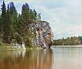
Chusovaya River in the Ural Mountains.
-
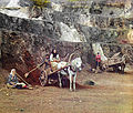
A mine in the Ural Mountains, 1910
See also
References
- ^ The Urals and Western Siberia in the Bronze and Iron Ages - Cambridge University Press
External links
- Template:Wikitravelpar
- Peakbagger.com page on the Ural Mountains
- Ural Expeditions & Tours page on the five parts of the Ural Mountains


