Vojvodina
- For the Yugoslav entity of the same name between 1945 and 1963 see Autonomous Province of Vojvodina (1945-1963) and for the Yugoslav entity of the period between 1963 and 1990, Socialist Autonomous Province of Vojvodina
The article's lead section may need to be rewritten. |
Autonomous Province of Vojvodina Аутономна Покрајина Војводина Autonomna Pokrajina Vojvodina Vajdaság Autonóm Tartomány Автономна Покраина Војводина Provincia Autonomă Voivodina Автономна Покраїна Войводина | |
|---|---|
 Vojvodina (red) is Serbia's autonomous province | |
| Capital and largest city | Novi Sad |
| Official languages | Serbian, Hungarian, Slovak, Romanian, Croatian, Pannonian Rusyn1 |
| Government | Government |
| Bojan Pajtić | |
| Sándor Egeresi | |
| Autonomy | |
| 1848 | |
| Area | |
• Total | 21,506 km2 (8,304 sq mi) (n/a) |
• Water (%) | n/a |
| Population | |
• 2002 census | 2,031,992 |
• Density | 94.51/km2 (244.8/sq mi) (n/a) |
| Time zone | UTC+1 (CET) |
• Summer (DST) | UTC+2 (CEST) |
| |
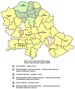
Vojvodina, officially called Autonomous Province of Vojvodina (Serbian: Аутономна Покрајина Војводина, Autonomna Pokrajina Vojvodina, ; Template:Lang-hu; Slovak: Autonómna Pokrajina Vojvodina; Template:Lang-ro; Croatian: Autonomna Pokrajina Vojvodina; Rusyn: Автономна Покраїна Войводина) is an autonomous province in Serbia. It is located in the northern part of the country, in the Pannonian Plain of Central Europe. It has a population of about 2 million, about 27% of Serbia's total. Its capital and largest city is Novi Sad, at over 370,000 people, while its second largest city is Subotica. Vojvodina prides itself on its multi-ethnicity and multi-cultural identity with a number of mechanisms for the promotion of minorities; there are more than 26 ethnic groups in the province, which has six official languages. The largest ethnic groups are Serbs (65%) and Hungarians (14%).
Name
The name "Vojvodina" in South Slavic languages simply means a type of duchy. It derives from the word "vojvoda" which stems from the Proto-Slavic language word "voevoda". Those words are etymologically connected with modern-day words "vojnik" (soldier) and "voditi" (lead). Its original historical name (from 1848) was the "Serbian Voivodship" (Srpska Vojvodina), but since Vojvodina is now a part of Serbia, there is no need for the prefix "Serbian" anymore.
The full official names of the province in all official languages of Vojvodina are:
- Аутономна Покрајина Војводина, Autonomna Pokrajina Vojvodina (in Serbian)
- Vajdaság Autonóm Tartomány (in Hungarian) ()
- Autonómna Pokrajina Vojvodina (in Slovak)
- Provincia Autonomă Voivodina (in Romanian)
- Автономна Покраина Војводина, Avtonomna pokraina Vojvodina (in Macedonian)
- Autonomna Pokrajina Vojvodina (in Croatian)
- Автономна Покраїна Войводина (in Pannonian Rusyn)
History

Throughout history, the territory of present day Vojvodina has been a part of Dacia, the Roman Empire, the Hun Empire, the Byzantine Empire, the Gepid Kingdom, the Avar Khanate, the Frankish Kingdom, the Kingdom of Croatia, the Great Moravia, the Bulgarian Empire, the Serbian Empire of Jovan Nenad, the Kingdom of Hungary, the Ottoman Empire, the Austrian Empire, Austria-Hungary, the Kingdom of Serbs, Croats and Slovenes, the Kingdom of Yugoslavia, the Independent State of Croatia, the Socialist Federal Republic of Yugoslavia, the Federal Republic of Yugoslavia, Serbia and Montenegro, and now Serbia.
Between 1849 and 1860, this region was referred to as Voivodship of Serbia and Tamiš Banat. After World War I in 1920, the region was detached from Hungary and was granted by the victorious allied powers to the Kingdom of Serbia in the Treaty of Trianon, and in 1945 it became part of Yugoslavia. Together with Kosovo-Metohija, it enjoyed autonomous status between 1945 and 1988, only it was an autonomous province since 1945, when Kosovo-Metohija was just an autonomous district, but they were given equal status in 1966.
Roman rule
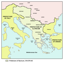
During Roman rule, Sirmium (today's Sremska Mitrovica) was one of the four capital cities of the Roman Empire and six Roman Emperors were born in this city or in its surroundings. The city was also the capital of several Roman administrative units, including the Lower Pannonia, the Pannonia Secunda, the Diocese of Pannonia, and the Praetorian prefecture of Illyricum. Roman rule lasted until the 5th century, after which the region came into the possession of various peoples and states. While Banat was a part of the Roman province of Dacia, Syrmium and Backa belonged to a Roman province of Lower Pannonia.
Keramikions
Slavs settled today's Vojvodina in the 6th and 7th centuries.[citation needed] According to the Miracles of Saint Demetrius, Avars gave the region to Kuber in the 670s. The Bulgars of Kuber moved south with Maurus to Macedonia where they cooperated with Tervel in the 8th century. Bunardzic dated Avar-Bulgar graves excavated in Chelarevo, containing skulls with Mongolian features and Judaic symbols, to the late 8th and 9th centuries. Erdely and Vilkhnovich consider the graves to belong to the Cavari-Cozri who eventually broke ties with the Khazar Empire between the 830s and 862. In the 9th century, Salan and Glad ruled over the region. The residence of Salan was Titel and that of Glad was possibly in the rumored rampart of Galad or perhaps Kladovo (Gladovo) in Serbia.
Hungarian rule
Most of Vojvodina became part of the Kingdom of Hungary in the 11th century and remained in Hungary until about 900 years later (1918/1920), except for the period of the Ottoman conquest (see below).
Its demographic balance started changing at the end of the 14th century, as it welcomed Serbian refugees fleeing from territories conquered by the Ottoman army. The first Turkish census, of 1557-58, described the northern parts of the territory having a Hungarian majority. Large numbers of Serbs were settled as a conscious policy on the part of the Habsburg emperor at the end of the 17th century. They were granted widespread exceptions and communal rights, in exchange for providing a border militia that could be mobilised against invaders from the south, as well as in case of civil unrest in Hungary.
In 1716, Vienna temporarily forbade settlement by Hungarians and Jews in the area, and large numbers of German speakers were settled instead. From 1782, Protestant Hungarians and Germans settled in large numbers again.
During the 1848-49 uprising, Vienna successfully mobilised the Serbian militias against the Hungarian government and the local Hungarians. The civil war hit this area perhaps the hardest, with terrible atrocities committed against the civilian populations. Following victory by the Habsburgs, a new administrative territory was created in the south that was maintained until 1860, with German as the official language.
The era following the Austro-Hungarian Compromise of 1867 was a period of economic flourishing but strained ethnic relations under the surface. After World War I the Treaty of Trianon (1920) gave Vojvodina to the Kingdom of Serbs, Croats and Slovenes, including majority Hungarian areas. Between 1918 and 1940, 80 000 Serbs were settled in the province.
Ottoman rule (1527-1716)
After the defeat of the Hungarian Kingdom at Mohács by the Ottoman Empire, the region fell into a period of anarchy and civil wars. In 1526 Jovan Nenad, a leader of the Serb mercenaries, established his rule in Bačka, northern Banat and a small part of Syrmia. He created an ephemeral independent state, with Subotica as its capital. At the peak of his power, Jovan Nenad proclaimed himself Serbian Emperor in Subotica. Taking advantage of the extremely confused military and political situation, the Hungarian noblemen from the region joined forces against him and defeated the Serbian troops in the summer of 1527. Emperor Jovan Nenad was assassinated and his state collapsed. A few decades later, the region was added to the Ottoman Empire, which ruled over it until the end of the 17th and the first half of the 18th century, when it was incorporated into the Habsburg Monarchy. The Treaty of Karlowitz of 1699, between Holy League and Ottoman Empire, marked the withdrawal of the Ottoman forces from Central Europe, and the supremacy of the Habsburg Empire in that part of the continent. According to the treaty, western part of Vojvodina passed to Habsburgs, see House of Keglević. Eastern part of it remained in Ottomans as Tamışvar Eyaleti until Austrian conquest in 1716. This statement is ratified by treaty of Passarowitz in 1718.
Periods of Serbian autonomy before 1918
At the beginning of Habsburg rule, most of the region was integrated into the Habsburg Military Frontier district, while western parts of Bačka were put under civil administration within Bač county. Later, the civil administration was expanded to other (mostly northern) parts of the region, while southern parts remained under military administration. Eastern part of it occupied by Ottomans between 1787-1788 during the Russo-Turkish War.

At the May Assembly in Sremski Karlovci (13–15 May 1848), Serbs declared the constitution of the Serbian Voivodship (Serbian Grand Duchy), a Serbian autonomous region within the Austrian Empire. The Serbian Voivodship consisted of Syrmia, Bačka, Banat, and Baranja. The metropolitan of Sremski Karlovci, Josif Rajačić, was elected patriarch, while Stevan Šupljikac was chosen as first voivod (duke).
In November 1849, in accordance with a decision made by the Austrian emperor, this Serbian region was transformed into the new Austrian crown land known as Voivodship of Serbia and Tamiš Banat. It consisted of Banat, Bačka, Syrmia, excluding the southern parts of these regions which were part of the Military Frontier. An Austrian governor seated in Temeschwar ruled the area, and the title of voivod belonged to the emperor himself. The full title of the emperor was "Grand Voivod of the Voivodship of Serbia" (German: Großwoiwode der Woiwodschaft Serbien). The province was abolished in 1860, and from 1867 was located again within the Hungarian Kingdom (part of Austria-Hungary).
At the end of World War I, the Austro-Hungarian Empire collapsed. On 29 October 1918, Syrmia became a part of the State of Slovenes, Croats and Serbs. On 31 October 1918, the Banat Republic was proclaimed in Temeschwar. The government of Hungary recognized its independence, but it was short-lived.
Serbian rule
On 25 November 1918, the Assembly of Serbs, and other nations of Vojvodina in Novi Sad proclaimed the union of Vojvodina (Banat, Bačka and Baranja) with the Kingdom of Serbia (The assembly numbered 757 deputies, of which 578 were Serbs, 89 Croats, 62 were Slovaks, 21 Ukrainians, 6 Germans and 1 Hungarian). One day before this, on 24 November, the Assembly of Syrmia also proclaimed the union of Syrmia with Serbia. On 1 December 1918, Vojvodina officially became part of the Kingdom of Serbs, Croats and Slovenes.

Between 1929 and 1941, the region was known as the Danube Banovina, a province of the Kingdom of Yugoslavia. Its capital city was Novi Sad. The Banovina consisted of the Syrmia, Bačka, Banat, Baranja, Šumadija, and Braničevo regions.
Between 1941 and 1944, during World War II, the Axis Powers divided and occupied Vojvodina. Bačka and Baranja were regained to Horthy's Hungary and Syrmia was attached to the Independent State of Croatia. A smaller Danube Banovina (including Banat, Šumadija, and Braničevo) existed as part of what was known as "Nedic's Serbia". The administrative centre of this smaller province was Smederevo. However, Banat itself was a separate autonomous region ruled by its German minority. The occupying powers committed numerous crimes against the civilian population, especially against Serbs and Jews; the Jewish population of Vojvodina was almost completely killed or deported.[citation needed]
Axis occupation ended in 1944 and the region was temporarily placed under military administration (1944–1945) run by the new communist authorities. During, and after the military administration, thousands of people were killed, interned, arrested, violate, tortured or expelled - this affected most of the German and Hungarian population.
The region was politically restored in 1945 as an autonomous province of Serbia (incorporating Syrmia, Banat, and Bačka). Instead of the previous name (Danube Banovina), the region regained its historical name of Vojvodina, while its capital city remained Novi Sad.
Legal status
At first, the province enjoyed only a small level of autonomy within Serbia, but it gained extensive rights of self-rule under the 1974 Yugoslav constitution, which gave both Kosovo and Vojvodina de facto veto power in the Serbian and Yugoslav parliaments, as changes to their status could not be made without the consent of the two Provincial Assemblies. The 1974 Serbian constitution, adopted at the same time, reiterated that "the Socialist Republic of Serbia comprises the Socialist Autonomous Province of Vojvodina and the Socialist Autonomous Province of Kosovo, which originated in the common struggle of nations and nationalities of Yugoslavia in the National Liberation War (the Second World War) and socialist revolution".
Under the rule of the Serbian president Slobodan Milošević, Vojvodina and Kosovo lost most of their autonomy in September 1990. Vojvodina was still referred to as an autonomous province of Serbia, but most of its autonomous powers - including, crucially, its vote on the Yugoslav collective presidency - were transferred to the control of Belgrade. The province, however, still had its own parliament and government and some other autonomous functions as well.
The fall of Milošević in 2000 created a new climate for reform in Vojvodina. Following talks between the political parties, the level of the province's autonomy was increased by the omnibus law in 2002. The statute of the Autonomous Province of Vojvodina is from 1991 and has been deemed by the Serbian Parliament as outdated. The Vojvodina provincial assembly adopted a new statute on 15 October 2008, 89 of 120 councilors voted in favor of the bill, whilst 21 voted against. The Statute, partly amended, was approved by Parliament of Serbia on 30 November 2009 with 137 MPs in favor and 24 against. The Statute was officially proclaimed on 14 December 2009, in Novi Sad, and came into force on 1 January 2010.
Geography

Vojvodina is situated in the northern part of Serbia. The region is divided by the Danube and Tisza rivers into: Bačka in the northwest, Banat in the east and Syrmia (Srem) in the southwest. A small part of the Mačva region is also located in Vojvodina, in the Srem District. Today, the western part of Syrmia is in Croatia, the northern part of Bačka is in Hungary, the eastern part of Banat is in Romania (with a small piece in Hungary), while Baranja (which is between the Danube and the Drava) is in Hungary and Croatia. Vojvodina has a total surface area of 21,500 km2 (8,300 sq mi). Vojvodina is also part of the Danube-Kris-Mures-Tisa euroregion.
Districts and municipalities

Column-generating template families
<div>...</div> open, potentially harming any subsequent formatting. | Type | Family | Handles wiki table code?† | Responsive/ mobile suited | Start template | Column divider | End template |
|---|---|---|---|---|---|---|
| Float | "col-float" | Yes | Yes | {{col-float}} | {{col-float-break}} | {{col-float-end}} |
| "columns-start" | Yes | Yes | {{columns-start}} | {{column}} | {{columns-end}} | |
| Columns | "div col" | Yes | Yes | {{div col}} | – | {{div col end}} |
| "columns-list" | No | Yes | {{columns-list}} (wraps div col) | – | – | |
| Flexbox | "flex columns" | No | Yes | {{flex columns}} | – | – |
| Table | "col" | Yes | No | {{col-begin}}, {{col-begin-fixed}} or {{col-begin-small}} | {{col-break}} or {{col-2}} .. {{col-5}} | {{col-end}} |
{| | || |- |} used to create tables? If not, special templates that produce these elements (such as {{(!}}, {{!}}, {{!!}}, {{!-}}, {{!)}})—or HTML tags (<table>...</table>, <tr>...</tr>, etc.)—need to be used instead.
After a constitution of Serbia from 1992, Vojvodina is divided into seven districts, which are called after its main geographical location. Districts are named after the main region which district covers. Minister of Local Government, in the Serbian Government appoints commissioners of the districts, but they have no political power. Local government lies in municipalities and cites. The seven districts are further subdivided into 43 municipalities and the cities of Novi Sad and Subotica. Template:VojvodinaDistricts
Cities

Largest cities of Vojvodina (with population figures):
- Novi Sad (284,252),
- Subotica (120,981),
- Zrenjanin (79,773),
- Pančevo (77,087),
- Sombor (51,471),
- Kikinda (41,935),
- Sremska Mitrovica (39,041),
- Vršac (36,001),
- Ruma (32,125),
- Bačka Palanka (29,431),
- Inđija (26,244),
- Vrbas (25,887),
- Bečej (25,703),
- Senta (20,363),
- Kula (19,293),
- Apatin (19,289),
- Temerin (19,143).
Demographics


Vojvodina is more diverse than the rest of Serbia with more than 25 ethnic groups and six official languages.[1]
Population by national or ethnic groups:[2]
| Number | % | |
| TOTAL | 2,031,992 | 100 |
| Serbs | 1,357,320 | 66.80 |
| Hungarians | 290,207 | 14.28 |
| Slovaks | 56,637 | 2.79 |
| Croats | 56,546 | 2.55 |
| Yugoslavs | 49,881 | 2.45 |
| Montenegrins | 35,513 | 1.75 |
| Romanians | 30,419 | 1.5 |
| Roma | 29,057 | 1.43 |
| Bunjevci | 19,776 | 1.05 |
| Pannonian Rusyns | 15,626 | 0.77 |
| Macedonians | 11,785 | 0.58 |
| Ukrainians | 4,635 | 0.23 |
| Muslims (by nationality) | 3,634 | 0.18 |
| Germans | 3,154 | 0.16 |
| Slovenes | 2,005 | 0.1 |
| Sokci | 1,864 | 0.1 |
| Albanians | 1,695 | 0.08 |
| Bulgarians | 1,658 | 0.08 |
| Czechs | 1,648 | 0.08 |
| Russians | 940 | 0.05 |
| Gorani | 606 | 0.03 |
| Bosniaks | 417 | 0.02 |
| Vlachs | 101 | 0 |
| Others | 5,311 | 0.26 |
| Regional identity | 10,154 | 0.5 |
| Undeclared | 55,016 | 2.71 |
| Unknown | 23,774 | 1.17 |
Population by native language:
| Number | % | |
| Serbian language | 1,557,020 | 76.63 |
| Hungarian language | 284,205 | 13.99 |
| Slovak language | 55,065 | 2.71 |
| Romanian language | 29,512 | 1.45 |
| Romani language | 21,939 | 1.08 |
| Croatian language | 21,053 | 1.04 |
| Macedonian language | 4,152 | n/a |
| Albanian language | 2,369 | n/a |
| Bulgarian language | 920 | n/a |
Population by religion:
| Number | % | |
| Eastern Orthodox Christians | 1,401,475 | 68.97 |
| Catholics (Roman Catholic and Eastern Rite) |
388,313 | 19.11 |
| Protestants | 72,159 | 3.55 |
| Atheists | 12,583 | n/a |
| Muslims | 8,073 | n/a |
| Jews | 329 | n/a |
| Oriental religions (Buddhism, Hinduism etc.) |
166 | n/a |
| Others | 4,456 | n/a |
| Without religious affiliation | 418 | n/a |
| Undeclared | 101,144 | n/a |
| Unknown | 42,876 | n/a |
Population by gender:
- 984,942 males
- 1,047,050 females
Population by age groups:
- 0–14 years: 15.85% (165,332 males, 156,873 females)
- 15–64 years: 68.62% (693,646 males, 700,416 females)
- 65 years and over: 15.53% (125,964 males, 189,761 females)
Source: Republic Statistical Office of Serbia
Politics
The current ruling coalition in the Vojvodina parliament (after 2008 elections) is composed of the following political parties: Democratic Party, G17 Plus, Hungarian Coalition, League of Social Democrats of Vojvodina, and Socialist Party of Serbia.
The current president of Vojvodinian government is Bojan Pajtić (Democratic Party), while the president of the Vojvodinian parliament is Sándor Egeresi (Hungarian Coalition).
Culture


Vojvodina also has regional academy of science and art, Vojvodina Academy of Sciences and Arts. Its main aim is to cherish traditions in sciences and arts of the multicultural and multiethnic circle through cooperation with other academies and institutions and to improve life conditions of the Vojvodina region by using the spiritual and natural resources of Vojvodina. The Government of Vojvodina is the founder of several newspapers and magazines in Vojvodina's official languages: Дневник [1] ("Daily news") in Serbian and Magyar Szó [2] ("Hungarian Word") in Hungarian are daily newspapers, and weekly magazines are Hrvatska riječ[3] ("Croatian Word") in Croatian, Hlas Ľudu [4] ("The Voice of the People") in Slovak, Libertatea [5] ("Freedom") in Romanian, and Руске слово [6] ("Rusyn Word") in Ukrainian. There is also Bunjevačke novine ("The Bunjevac newspaper") in Bunjevac. Hidden Europe article praises the cosmopolitism in the province.[3]
Tourism
Tourist destinations in Vojvodina include well known Orthodox monasteries on Fruška Gora mountain, numerous hunting grounds, cultural-historical monuments, different folklores, interesting galleries and museums, plain landscapes with a lot of greenery, big rivers, canals and lakes, sandy terrain Deliblatska Peščara ("the European Sahara"), etc.
Economy
The economy of Vojvodina is largely based on developed food industry and fertile agricultural soil that make up 84% of its territory. About 70% of agricultural products is corn, 20% industrial herbs, and 10% other agricultural cultures. Other branches of industry are also developed such as the metal industry, chemical industry, electrical industry, oil industry and construction industry.
Companies:
Human rights
In 2005, several international organizations including the European Parliament and Human Rights Watch have expressed concern about rising levels of ethnic tension and related violent incidents in Vojvodina.[4] Of particular concern, according to the reports, is a frequently lax response on the part of the police.
Gallery
-
Catholic Church in Vršac
-
Sombor in 1905
-
The Uniate cathedral in Ruski Krstur
-
Catholic Church in Sonta
-
The Romanian Orthodox church in Vršac
See also
- 1942 raid in Novi Sad
- 1944-1945 killings in Bačka
- Bačka
- Banat
- Crimes of the occupants in Vojvodina, 1941-1944
- Ethnic groups of Vojvodina
- Syrmia
References
- ^ Johnstone, Sarah (2007). Europe on a shoestring. Lonely Planet. p. 981. ISBN 9781741045918.
- ^ Zoran Jančić, ed. (2002). "3. Population by national or ethnic groups by Census 2002, by municipalities". Issue LII, No. 295, Final Results of the Census 2002 (PDF) (Communication ed.). Belgrade: Republic Statistical Office of Serbia. pp. 6–7. YU ISSN 0353-9555 SRB 295 SN31 241202.
{{cite book}}: Unknown parameter|month=ignored (help) - ^ hidden europe magazine - Articles - hidden europe 13 (March 2007) - two communities in Banat
by Laurence Mitchell - ^ Dangerous Indifference: Violence against Minorities in Serbia: Assaults on Minorities in Vojvodina
External links
- Template:En icon Template:Sr icon Government of the Autonomous Province of Vojvodina
- Template:En icon Template:Sr icon Template:Hu icon Template:Sk icon Template:Ro icon (Rusyn) Template:Hr icon
- Template:En icon Template:Sr icon Provincial Secretariat for Regional and International Cooperation
- Useful information about Vojvodina, Parks of Nature, River Expedition, Wine Trails, Cities, Etno, Adventure and more
- Interactive map of Novi Sad
- Atlas of Vojvodina (Wikimedia Commons)
- Statistical information about municipalities of Vojvodina
- List of largest cities of Vojvodina
- Template:Hu icon The encyclopedia of Vojvodina


