
Herzegovina
Herzegovina (region) | |
|---|---|
Region | |
 Approximate borders between the regions of Bosnia (orange) and Herzegovina (blue) | |
| Country | Bosnia and Herzegovina |
| Largest city | Mostar |
| Area | |
| • Total | 11,000 km2 (4,000 sq mi) |
| Time zone | UTC+1 (CET) |
| • Summer (DST) | CEST |
Herzegovina (/ˌhɛərts[invalid input: 'ɨ']ˈɡoʊv[invalid input: 'ɨ']nə/[1] or /ˌhɜːrtsəɡoʊˈviːnə/;[2] Bosnian, Croatian and Serbian: Hercegovina, Cyrillic: Херцеговина, [xɛ̌rtsɛɡov̞ina]) is the southern region of Bosnia and Herzegovina. While there is no official border distinguishing it from the Bosnian region, it is generally accepted that the borders of the region are Croatia to the west, Montenegro to the south, the canton boundaries of the Herzegovina-Neretva Canton to the east, and Gornji Vakuf-Uskoplje to the north. Measurements of the area range from 11,419 km2 (4,409 sq mi),[3] or around 22% of the total area of the present-day country[4] to 12,276 km2 (4,740 sq mi), around 24% of the country.[5]
The name Herzegovina means "duke's land", referring to the medieval duchy of Stjepan Vukčić Kosača who took title "Herzeg of Saint Sava". Herceg is derived from the German title Herzog.[6][7]
Population
While the population of Herzegovina throughout history has been ethnically mixed, the Bosnian War in the 1990s resulted in mass ethnic cleansing and large-scale displacement of people. The last pre-war census in 1991 recorded a population of 437,095 inhabitants.
Croats generally populate the areas closest to the Croatian border focused on Mostar (the western part), Ljubuški, Široki Brijeg, Čitluk, Grude, Posušje, Čapljina, Neum, Stolac, Ravno and Tomislavgrad. The Bosniak population mainly lives in the areas along the Neretva River, Ulog, Glavatičevo, Konjic and Jablanica, as well as the eastern part of Mostar, Blagaj, Počitelj and to significant extent Stolac, Ljubuški, Čapljina, and lesser extent in Nevesinje, Gacko, Trebinje. Serbs are the majority in eastern Herzegovina, including the municipalities of Berkovići, Bileća, Gacko, Istočni Mostar, Ljubinje, Nevesinje, Foča and Trebinje.
History
| History of Herzegovina |
|---|
|
|
|
In the early Middle Ages, the territory of modern Bosnia and Herzegovina was divided into many smaller more or less independent territories. Herzegovina encompasses the regions then known as the land of Hum or Zahumlje and Travunija, through the late Middle Ages belonging to the Serbian kings of the Nemanjić dynasty. The westernmost parts of Herzegovina belonged to the Kingdom of Croatia until its union with Kingdom of Hungary in 1102. Bosnian Ban Stjepan II Kotromanić and King Tvrtko I Kotromanić adjoined these regions to the Bosnian state in the 14th century.

Following the weakening of the Bosnian crown after the death of Tvrtko I, powerful noblemen of the Bosnian Kosača family, Grand Duke Sandalj Hranić and his nephew, Herzog Stefan Vukčić, ruled the Hum region independently, only nominally recognizing the overlordship of the Bosnian kings. In a document sent to Frederick III on January 20, 1448, Bosnian duke Stjepan Vukčić Kosača called himself Herzog (duke) of Saint Sava, lord of Hum and Primorje, great duke of the Bosnian kingdom and so the lands he controlled became (much later) known as Herzog’s lands or Herzegovina.

In 1482, the lands of Herzog Stefan's successors were occupied by Ottoman forces. In the Ottoman Empire, Herzegovina was organized as a Herzegovina Sanjak within the Bosnia Eyalet. From 1833 to 1851, Herzegovina was the separate Herzegovina Eyalet ruled by vizier Ali-paša Rizvanbegović. After his death, the eyalets of Bosnia and Herzegovina were merged. The new joint entity was after 1853 commonly referred to as Bosnia and Herzegovina. Throughout the mid-19th century, Herzegovina was a target of expansion of the young Montenegrin state in the name of the liberation of the Serbian people from Ottoman rule. Herzegovinian Serbs and Croats actively participated in the Montenegrin efforts to liberate them and to that end, they frequently rose in rebellion against the Ottoman rule. These efforts culminated in 1875 and 1876, during the Herzegovinian rebellion (Nevesinjska puška) uprising. Montenegro did succeed in liberating and annexing large parts of Herzegovina before the Berlin Congress of 1878, including the Nikšić area.
In 1878, Herzegovina, along with Bosnia, was occupied by Austria-Hungary, only nominally remaining under Ottoman rule. This caused great resentment among its populace, which resisted the invaders in small flare-ups of rebellious activity that ended in 1882. The Serbian population of Herzegovina and Bosnia had hoped that the province would be divided and annexed to Serbia and Montenegro. The occupation caused a temporary rift in the Serbo-Austrian relations and threatened to grow into an open conflict.
In 1908, Austria-Hungary annexed the province, leading to the Bosnian Crisis, an international dispute which barely failed to precipitate a world war immediately, and was an important step in the buildup of international tensions during the years leading up to the First World War. The assassination of the Archduke Franz Ferdinand came as a direct result of the resentment of the Serbs of Bosnia and Herzegovina against Austro-Hungarian rule.
During World War I, Herzegovina was a scene of inter-ethnic conflict. During the war, the Austro-Hungarian government formed Šuckori, Muslim and Croat militia units. Šuckori units were especially active in Herzegovina.
In 1918, Herzegovina became a part of the newly formed Kingdom of Serbs, Croats and Slovenes (later renamed Kingdom of Yugoslavia). In 1941 Herzegovina fell once again under the rule of the fascist Independent State of Croatia. From 1941 to 1945, Herzegovina was a battleground for conflicts between Croatian Ustaše, Serbian Četniks, and the pan-Yugoslav Partisans. In 1945, Bosnia and Herzegovina became one of the republics of SFR Yugoslavia. It remained so until the breakup of Yugoslavia in the early 1990s.
Political status
In the modern Bosnian-Herzegovinian state, Herzegovina is divided between two entities, Republika Srpska and the Federation of Bosnia and Herzegovina (see Bosnia and Herzegovina and History of Bosnia and Herzegovina). Republika Srpska's part of Herzegovina, commonly referred to as East Herzegovina or, as of late, Trebinje Region is administratively divided into municipalities of Trebinje, Bileća, Gacko, Nevesinje, Ljubinje, Berkovići, Istočni Mostar and Foča. Within the Federation of Bosnia and Herzegovina, Herzegovina is administratively divided between the cantons of Herzegovina-Neretva, West Herzegovina and includes the Tomislavgrad municipality, which is part of the Canton 10.
Geography

The terrain of Herzegovina is mostly hilly karst with high mountains in the north such as Čvrsnica and Prenj, except for the central valley of the river Neretva. The largest city is Mostar, in the center of the region. Other larger towns include Trebinje, Stolac, Široki Brijeg, Konjic and Čapljina. Borders between Bosnia and Herzegovina are unclear and often disputed.
The upper flow of the river Neretva lies in the northern parts of Herzegovina, a heavily forested area with fast flowing rivers and high mountains. Towns like Konjic and Jablanica lie in this area, considered by many the most beautiful part of Bosnia and Herzegovina.
The Neretva rises on Lebršnik Mountain, close to the border to Montenegro, and as the river flows towards west, it enters Herzegovina. The entire upper catchment of Neretva constitutes a precious ecoregion with many endemic and endangered species. Fast flowing emerald river carves its way through the precipitius karst terrain, providing excellent opportunities for rafting and kayaking, while the spectacular scenery of the surrounding mountains and forests is a challenging hiking terrain.
The Neretva's tributaries in the upper flow are mostly short, due to the mountainous terrain: Notably river Rakitnica has cut a deep canyon, its mystical waters being one of the least explored areas in this part of Europe. River Rakitnica flows into Neretva upstream from Konjic.
The Neretva then flows towards northwest, through the town of Konjic. The river enters the artificial Jablanica Lake ("Jablaničko jezero"), one of the biggest in Bosnia and Herzegovina. The lake ends near the town of Jablanica, famous for the Battle of Neretva, marking a crucial victory of Yugoslav Partisans over the German army and its quisling allies during World War II. From here on, the Neretva turns southward continuing its course towards the Adriatic Sea.
With mountains lining its shores gradually receding, the Neretva enters a valley where the city of Mostar lies. It flows under the famous old bridge Stari most and continues now more widely flowing towards the town of Čapljina and the Neretva Delta in Croatia before emptying into the Adriatic Sea.
Cities
There are several well-known cities in Herzegovina. Mostar is the most famous and the unofficial capital. It is also the only city with over 100,000 citizens. There are no other large cities in Herzegovina, though some have famous histories. Stolac, for example, is perhaps the oldest city in Herzegovina. There have been settlements dating from the Paleolithic period (Badanj cave). An Illyrian tribe lived in the city of Daorson. There were several Roman settlements alongside the Bregava river and medieval inhabitants left large and beautiful stone grave monuments called stećak in Radimlja. Trebinje, on the river Trebišnjica, is the southernmost city in Bosnia and Herzegovina, near the border with Montenegro. Čapljina and Ljubuški are famous for their history and their rivers; the village of Međugorje has religious importance for many Croats and Catholics.
Tourism
In Herzegovina there are many beautiful and famous natural landmarks, such as the falls of Kravica. These consist of several waterfalls near the city of Ljubuški and a popular spot for the local people, to take a bath in the hot Herzegovinian weather, or just to enjoy the view.
The Hutovo Blato is a bird reserve, one of the most important in Europe and a gathering place for many international ornithologists.
Vjetrenica cave is a cave system near the border with Croatia, in the Ravno municipality. The cave has not been explored totally yet but it is open for visitors. More and more species are being discovered there and it is a unique ecosystem with cave animals and other interesting things.
Blagaj is also famous as the origin of the river Buna, inside a cave system.
Neum at the Adriatic Sea, Bosnia and Herzegovina's only coastal town, is also a popular tourist attraction.
Gallery
-
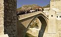 The "Old Bridge" ("Stari most") in Mostar, rebuilt in 2004.
 -
 Neum and the Herzegovinian coast.
 -
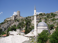 Počitelj, Old town
 -
-

-
 Bilećko jezero (Bileća Lake)


See also
- Bosanska Krajina
- Bosnia (region)
- Herceg Novi
- Herzegovinians
- Old Herzegovina
- Sutjeska National Park
- Zahumlje
References
- ^ Template:USdict
- ^ http://www.yourdictionary.com/bosnia-and-herzegovina
- ^ Administrativno uređenje Hercegovine od 1945. do 1952. godine by Adnan Velagić, published in Most - časopis za obrazovanje, nauku i kulturu, No. 191, Year 2005 (October), pp. 82-84. ISSN 0350-6517
- ^ http://encyclopedia.farlex.com/Hercegovina
- ^ Ekonomska regija Hercegovina, Regionalna razvojna agencija za Hercegovinu (REDAH) in conjunction with the EU RED Project, Bosnia and Herzegovina, November, 2004, pp 24-26
- ^ http://books.google.com/books?id=KCGbWCouJ6AC&pg=PA51
- ^ http://books.google.com/books?id=-WIEYZ-SMHEC&pg=PA3
