Brandenburg-Briest Solarpark
Appearance
| Brandenburg-Briest Solarpark | |
|---|---|
 | |
 | |
| Country | Germany |
| Location | Brandenburg and Briest |
| Coordinates | 52°26′12″N 12°27′05″E / 52.43667°N 12.45139°E |
| Status | Operational |
| Commission date | December 2011 |
| Owners | LUXCARA, MCG Group |
| Solar farm | |
| Type | PV crystalline silicon modules |
| Power generation | |
| Units operational | 383,000 |
| Nameplate capacity | 91 MW |
| Annual net output | 89.5 GWh |
| External links | |
| Commons | Related media on Commons |
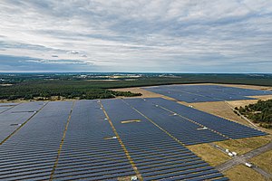
Brandenburg-Briest Solarpark is photovoltaic power station, located at a former military airfield in Brandenburg, Germany. At the time of its completion, it was the largest solar park in Europe.[1] Equipped with Q-Cells solar modules, it consists of three sections, namely
- Brandenburg-Briest East (30 MW)
- Brandenburg-Briest West (30 MW)
- and Briest-Havelsee (31 MW)
that add up to a total installed capacity of 91 megawatts (MW), sufficient to supply the electricity needs of more than 11,500 households.[2][3]
See also
[edit]- Photovoltaic power stations
- List of largest power stations in the world
- List of photovoltaic power stations
References
[edit]

