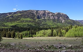
South San Juan Wilderness
Appearance
| South San Juan Wilderness | |
|---|---|
 A mountain the wilderness area at the confluence of the Conejos and South Fork Conejos rivers | |
| Location | Archuleta / Conejos counties, Colorado, USA |
| Nearest city | Pagosa Springs, CO |
| Coordinates | 37°40′N 106°38′W / 37.667°N 106.633°W[1] |
| Area | 158,790 acres (642.6 km2) |
| Established | 1980 |
| Governing body | U.S. Forest Service |
The South San Juan Wilderness is a U.S. Wilderness Area located in the San Juan National Forest, east of Pagosa Springs, in southern Colorado .[2]
The last known grizzly bear in Colorado was killed in the wilderness in 1979. Some believe that it is still home to a few grizzlies, but there is no sufficient evidence yet to prove this.
Recreation
The wilderness area contains: 32 lakes; many peaks above 13,000 feet (4,000 m), the highest of which is Summit Peak at 13,307 feet; and 180 miles (290 km) of hiking trails, that includes 42 miles (68 km) of the Continental Divide Trail. [citation needed]
References
- ^ "South San Juan Wilderness". Geographic Names Information System. United States Geological Survey, United States Department of the Interior. Retrieved August 7, 2012.
- ^ "South San Juan Wilderness". Wilderness.net. Retrieved August 7, 2012.
Categories:
- IUCN Category Ib
- Wilderness Areas of Colorado
- San Juan National Forest
- San Juan Mountains (Colorado)
- Sangre de Cristo National Heritage Area
- Protected areas of Archuleta County, Colorado
- Protected areas of Conejos County, Colorado
- Protected areas established in 1980
- 1980 establishments in Colorado
- Colorado protected area stubs

