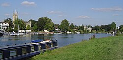
Hampton Ferry (River Thames)

Hampton Ferry is a pedestrian and cycle ferry service across the River Thames in England.
Details
The ferry links Hampton, on the north bank and in the London Borough of Richmond, with Moulsey or Molesey Hurst, the largest park of Molesey on the south bank and in the county of Surrey.[1]
The ferry is in the reach of the river between Molesey Lock and Sunbury Lock. It is the only Thames crossing on this reach, and the only crossing between Hampton Court Bridge and Walton Bridge.
The ferry operates in the months March to October; on both weekends and weekdays the service is on demand. It can be boarded opposite Hampton's oldest Church on the north bank, and by the Molesey Heritage Marker on the south bank.[2]
The ferry has been operating since 1514, with the first crossings made from the town of Hampton in order for fishermen to be able to catch fish in the then seasonally marshy and reed-laden Moulsey Hurst, which stretched further than today into the settlement of Molesey.[3] Its incorporation by statute makes the ferry one of the 10 oldest established companies in the United Kingdom, and places it among the 150 oldest companies in Europe.
See also
References
- ^ Rowland G. M. Baker Thameside Molesey 1989
- ^ "Thames Landscape Strategy Kingston to Kew:Things to do". Archived from the original on 24 July 2008. Retrieved 29 September 2008.
- ^ http://www.hamptonferryboathouse.co.uk
External links
 Media related to Hampton Ferry at Wikimedia Commons


