
Venetian Causeway
Venetian Causeway | |
|---|---|
 View of the Venetian Causeway from Downtown Miami, east toward Miami Beach in 2002. | |
| Coordinates | 25°47′28″N 80°09′54″W / 25.791°N 80.165°W |
| Crosses | Biscayne Bay |
| Locale | Miami to Miami Beach |
| Maintained by | MDX |
| Heritage status | NRHP (1989)[1] |
| Preceded by | Collins Bridge |
| Characteristics | |
| Design | Bascule |
| Total length | 2.8 miles (4.5 km) |
| Longest span | 0.4 miles (0.64 km) |
| History | |
| Designer | Harvey Stanley, Raymond Concrete Pile Co. |
| Opened | 1925 (original causeway & bridges) 1999 (current bridges) |
| Statistics | |
| Toll | $3.00[2] |
Venetian Causeway | |
| NRHP reference No. | 89000852[3] |
| Added to NRHP | July 13, 1989 |
| Location | |
 | |
The Venetian Causeway crosses Biscayne Bay between Miami on the mainland and Miami Beach on a barrier island in south Florida. The man-made Venetian Islands and non-bridge portions of the causeway were created by materials which came from the dredging of the bay. The Venetian Causeway follows the original route of the Collins Bridge, a wooden 2.5 mi (4 km) long structure built in 1913 by John S. Collins and Carl G. Fisher which opened up the barrier island for unprecedented growth and development.
The causeway has one toll plaza (administered by the Miami-Dade County Public Works department[4]) on Biscayne Island, the westernmost Venetian Island. The toll for an automobile is $3.00 (US).[5]
The causeway has two bascule bridges.
At the Downtown/Western Beginning of the causeway travelers are greeted by two columns vertically saying "VENETIAN WAY" along with a sign indicating that there is a weight limit .
At the South Beach/Eastern Terminus, drivers must choose whether to go north onto Dade Boulevard or eastbound onto 17th Street to Ocean Drive, Collins Ave/A1A, Lincoln Road, City Hall, The Convention Center, Jackie Gleason Theater and the beach .
The Venetian Causeway was re-dedicated in 1999 after the completion of a $29 million restoration and replacement project.[6]
A popular use of the causeway is for exercising, including both jogging and bicycling.
See also
- Belle Isle
- Collins Bridge
- Di Lido Island
- Biscayne Island
- Rivo Alto Island
- John S. Collins
- Carl G. Fisher
Gallery
-
 View of the Venetian Causeway and islands with South Beach in the background, as seen from the 1800 Club in Downtown Miami
 -
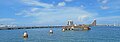
 The westernmost of the two drawbridges on the causeway, with its draw span opened for a boat
 -
 View from water level towards Miami Beach
 -
 View towards Miami Beach
 -
 The Venetian Causeway viewed from former site of The Miami Herald
 -
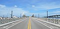
 Entrance to Venetian Causeway from Miami side
 -
 Column with Sign
 -
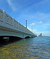
 Bridge detail, lamps and railing
 -
 Entrance to Venetian Causeway with Columns view towards southeast
.jpg)


References
- ^ "National Register Information System". National Register of Historic Places. National Park Service. March 15, 2006.
- ^ https://www.miamidade.gov/parks/venetian.asp
- ^ "National Register Information System". National Register of Historic Places. National Park Service. 2006-03-15. Archived from the original on 2010-05-27.
- ^ Miami-Dade County Public Works department
- ^ https://www.miamidade.gov/parks/venetian.asp
- ^ The City of Miami Beach Community Bridges The Past With The New Millennium Archived 2006-10-05 at the Wayback Machine, October 28, 1999
External links
Crossings of the Biscayne Bay | ||||
|---|---|---|---|---|
| ||||
- Toll bridges in Florida
- Roads in Miami
- Roads in Miami Beach, Florida
- Roads in Miami-Dade County, Florida
- Causeways in Miami-Dade County, Florida
- Intracoastal Waterway
- Road bridges on the National Register of Historic Places in Florida
- National Register of Historic Places in Miami-Dade County, Florida
- Bridges completed in 1913
- Road bridges in Florida
- Drawbridges on the National Register of Historic Places
- 1913 establishments in Florida
- Concrete bridges in the United States
- Bascule bridges in the United States