Eyre Creek (Lake Eyre basin)
| Eyre Creek | |
|---|---|
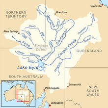
 Lake Eyre drainage basin including the major rivers | |
| Location | |
| State | Queensland |
| State | South Australia |
| Physical characteristics | |
| Source | Confluence of the Georgina River and the Burke River |
| • location | Marion Downs Station |
| Mouth | Warburton River at the confluence of Eyre Creek and the Diamantina River |
• coordinates | 26°40′47″S 138°59′16″E / 26.67964°S 138.987866°E |
| Basin features | |
| River system | Lake Eyre Basin |
| Tributaries | |
| • left | Hamilton River |
Eyre Creek is a tributary of the Warburton River. It flows from the western southwest corner of Queensland into the northeastern corner of South Australia.[1]
Eyre Creek is fed by the Georgina River and Burke River in the vicinity of Marion Downs Station.[2] The confluence of Eyre Creek and the Diamantina River is the source of the Warburton River.
References[edit]
- ^ "Search result for 'Eyre Creek, Strm' with the following datasets selected - 'Water Courses', 'Suburbs and Localities' and 'Gazetter'". Location SA Map Viewer. Government of South Australia. Retrieved 8 February 2019.
- ^ "Georgina - Eyre Creek Basin map". Rainfall and River Conditions. Bureau of Meteorology. Retrieved 27 December 2018.
