
Sydney central business district
| Sydney City Centre Sydney, New South Wales | |||||||||||||||
|---|---|---|---|---|---|---|---|---|---|---|---|---|---|---|---|
 Sydney City Centre | |||||||||||||||
 Sydney City Centre | |||||||||||||||
 | |||||||||||||||
| Coordinates | 33°52′5″S 151°12′44″E / 33.86806°S 151.21222°E | ||||||||||||||
| Population | 17,252 (2016)[1] | ||||||||||||||
| • Density | 6,160/km2 (15,960/sq mi) | ||||||||||||||
| Postcode(s) | 2000 | ||||||||||||||
| Area | 2.8 km2 (1.1 sq mi) | ||||||||||||||
| LGA(s) | City of Sydney | ||||||||||||||
| State electorate(s) | Sydney | ||||||||||||||
| Federal division(s) | Sydney | ||||||||||||||
| |||||||||||||||
The Sydney Central Business District (CBD) is the historical centre and the main commercial centre of Sydney, located on iconic Sydney Harbour. The Sydney CBD is Sydney's city centre, or Sydney City, and the two terms are used interchangeably. The CBD or city centre is often referred to simply as "Town" or "the City". The Sydney city centre extends southwards for about 3 km (2 mi) from Sydney Cove, the point of first European settlement in which the Sydney region was initially established. Due to its pivotal role in Australia's early history, it is one of the oldest established areas in the country.
Geographically, its north–south axis runs from Circular Quay in the north to Central railway station in the south. Its east–west axis runs from a chain of parkland that includes Hyde Park, The Domain, Royal Botanic Gardens and Farm Cove on Sydney Harbour in the east; to Darling Harbour and the Western Distributor in the west. At the 2016 Australian Census, the City recorded a population of 17,252.[1]
The Sydney City is Australia's main financial and economic centre, as well as a leading hub of economic activity for the Asia-Pacific region. The city centre and areas immediately around it employ approximately 22% of the Sydney region's workforce. The City has the largest gathering of workers in the whole of Sydney. Most of them are white collar office workers in the finance and professional service industries. In 2012, the number of workers operating in the City was 226,972.[2] Based on industry mix and relative occupational wage levels it is estimated that economic activity (GDP) generated in the city in 2015/16 was approximately $118 billion.[3] Culturally, the city centre is Sydney's focal point for nightlife and entertainment. It is also home to some of the city's most significant buildings and structures.
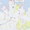
Geography and urban structure
.jpg)
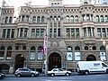
The Sydney CBD is an area of very densely concentrated skyscrapers and other buildings, interspersed by several parks such as Hyde Park, The Domain, Royal Botanic Gardens and Wynyard Park. George Street is the Sydney CBD's main north–south thoroughfare. The streets run on a slightly warped grid pattern in the southern CBD, but in the older northern CBD the streets form several intersecting grids, reflecting their placement in relation to the prevailing breeze and orientation to Circular Quay in early settlement.
The CBD runs along two ridge lines below Macquarie Street and York Streets. Between these ridges is Pitt Street, running close to the course of the original Tank Stream (now tunnelled). Bridge Street took its name from the bridge running east–west that once crossed this stream. Pitt Street is the retail heart of the city which includes the Pitt Street Mall and the Sydney Tower. Macquarie Street is a historic precinct that houses such buildings as the State Parliament House and the Supreme Court of New South Wales.

Boundaries
| Sydney (suburb) Sydney, New South Wales | |
|---|---|
 Map | |
| Population | 16,667 (SAL 2021)[4] |

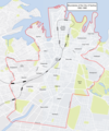
The New South Wales Geographical Names Board defines the area covering the central business district as the suburb named "Sydney".[5] The formal boundaries of the suburb "Sydney" covers most of the peninsula formed by Cockle Bay in the west and Woolloomooloo Bay in the east. It extends north to Circular Quay, Bennelong Point and Mrs Macquarie's Chair, east to Woolloomooloo Bay and the eastern boundary of the Domain and Hyde Park, south to Goulburn Street just north of Sydney's Chinatown (Haymarket), and west to cover the Darling Harbour area on the western shore of Cockle Bay. However, it does not include the northwestern portion of the peninsula which includes the Barangaroo, the Rocks, Miller's Point, Dawe's Point and Walsh Bay area, which are formally separate suburbs grouped by the City of Sydney into the "small area" called "The Rocks - Miller's Point - Dawe's Point".[6][7] Although not part of the CBD, Chinatown, Haymarket, the Rocks, Miller's Point and Dawe's Point are often regarded as part of the city centre.
The postcode zone 2000 is also roughly correlative with the city centre.
"Sydney City" is very occasionally used to refer not only to the City proper, but also its nearby inner suburbs such as Pyrmont, Haymarket, Ultimo and Woolloomooloo.
City of Sydney boundaries over time
The City of Sydney is traditionally the governing authority for Sydney's city centre. However, the boundaries of the City of Sydney have always been larger than the city centre or CBD. For example, Pyrmont has been in the City of Sydney since 1842 but is usually considered to be an inner western suburb, not a part of the Sydney city centre or CBD. Today's City of Sydney is far larger than the city centre or CBD.
-
 Boundaries pre–1909
 -
 Boundaries 1909–1948
 -
 Boundaries 1949–1968
 -
 Boundaries 1968–1982
 -
 Boundaries 1982–1988
 -
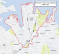 Boundaries 1989–2003


History

,_1933-1942_(15806644966)_(2).jpg)
Sydney's history begins in prehistoric times with the occupation of the district by Australian Aboriginals, whose ancestors came to Sydney in the Upper Paleolithic period.[8] Radiocarbon dating suggests that they lived in and around Sydney for at least 30,000 years.[9] Sydney Cove from Port Jackson to Petersham was inhabited by the Cadigal clan. The principal language groups were Darug, Guringai, and Dharawal.[10] The modern history of the city began with the arrival of a First Fleet of British ships in 1788 and the foundation of a penal colony by Great Britain. The area surrounding Port Jackson (Sydney Harbour) was home to several Aboriginal tribes. The "Eora people" are the coastal Aborigines of the Sydney district. The name Eora simply means "here" or "from this place", and was used by Local Aboriginal people to describe to the British where they came from.
After arriving to Botany Bay, Captain Arthur Phillip decided that the area was not suitable since it had poor soil, no secure anchorage and no reliable water source.[11] Thus, the fleet moved to the more suitable Port Jackson where a settlement was established at Sydney Cove on 26 January 1788.[12] This date later became Australia's national day, Australia Day. The colony was formally proclaimed by Governor Phillip on 7 February 1788 at Sydney. Sydney Cove offered a fresh water supply and Port Jackson a safe harbour, which Phillip described as: "being without exception the finest Harbour in the World".[13] With the expansion of European settlement large amounts of land was cleared for farming, which resulted in the destruction of Aboriginal food sources. This, combined with the introduction of new diseases such as smallpox, caused resentment within the Aboriginal clans against the British and resulted in violent confrontations.[14]
The oldest legislative body in Australia, the New South Wales Legislative Council, was created in Sydney in 1825 as an appointed body to advise the Governor of New South Wales. The northern wing of Macquarie Street's's Rum Hospital was requisitioned and converted to accommodate the first Parliament House in 1829, as it was the largest building available in Sydney at the time.[15] In 1840 the Sydney City Council was established. Australia's first parliamentary elections were conducted for the New South Wales Legislative Council in 1843.[16] The passing of the Sydney Incorporation Act in 1842 officially recognised the colonial settlement as a township and imposed a managerial structure to its administration.
Macquarie set aside a large portion of land for an Anglican Cathedral and laid the foundation stone for the first St Mary's Catholic Cathedral in 1821. St Andrew's Anglican Cathedral, though more modest in size than Macquarie's original vision, later began construction and, after fire and setbacks, the present St Mary's Catholic Cathedral foundation stone was laid in 1868, from which rose a towering gothic-revival landmark.[17] Religious groups were also responsible for many of the philanthropic activities in Sydney. One of these was the Sydney Female Refuge Society set up to care for prostitutes in 1848.[18] An academy of art formed in 1870 and the present Art Gallery of New South Wales building began construction in 1896.[19] Inspired by the works of French impressionism, artists camps formed around the foreshores of Sydney Harbour in the 1880s.[20] The Romanesque landmark Queen Victoria Building (QVB), designed by George McRae, was completed in 1898 on the site of the old Sydney markets.
In the midst of World War 1, on Valentine's Day, riots racked the CBD, in what has come to be known as the Central Station Riots of 1916. A substantial segment of the violence was concentrated in the Central area. These riots involved five thousand military recruits who refused to comply with extraneous parade orders. During the riots they caused significant damage to buildings. People with "foreign" names were especially targeted. The recruits clashed with soldiers, resulting in the death of Private Ernest William Keefe. Eight people sustained injuries. Because this incident occurred in the middle of the Great War the state discouraged media coverage. Only a fifth of the rioters were court-marshalled. These riots spurred the introduction of lockout laws for pubs after 6 pm. This law was only lifted in 1955.[21]
Governance
Administratively, the Sydney CBD falls under the authority of the local government area of the City of Sydney.[22] The New South Wales state government also has authority over some aspects of the CBD, in particular through Property NSW.
In the New South Wales state parliament, the seat of "Sydney" covers the city centre together with inner western, southern and eastern suburbs. Independent Alex Greenwich has represented the state seat of Sydney since the 2012 by-election, triggered by the resignation of previous independent Clover Moore, who was the Lord Mayor of Sydney, due to introduced state laws preventing dual membership of state parliament and local council.[citation needed]
In the federal parliament, the seat of "Sydney" covers the city centre together with a larger set of inner western, southern and eastern suburbs, as well as islands in the Sydney Harbour and Lord Howe Island. Australian Labor Party member Tanya Plibersek has represented the federal seat of Sydney since the 1998 Australian federal election.[citation needed]
Commercial area

The Sydney CBD is home to some of the largest Australian companies, as well as serving as an Asia-Pacific headquarters for many large international companies. The financial services industry in particular occupies much of the available office space, with companies such as the Westpac, Commonwealth Bank of Australia, Citibank, Deutsche Bank, Macquarie Bank, AMP Limited, Insurance Australia Group, AON, Marsh, Allianz, HSBC, Axa, ABN Amro,[23] RBC and Bloomsbury Publishing all having offices.[24]
Transport

Sydney's CBD is serviced by commuter rail, light rail, bus and ferry transport.
Sydney's main commuter rail hub is Central Railway Station ("Central"), which is located to the south of the CBD in Haymarket: it connects services for almost all of the lines in the Sydney Trains network, as well as being the terminus for NSW TrainLink country and inter-urban rail services. From Central, there is a largely-underground CBD rail loop, accessed in both directions via Central, which services five CBD stations (Town Hall, Wynyard, Circular Quay, St James and Museum). This is known as the City Circle. In addition, a separate underground line to Bondi Junction services an additional underground station, Martin Place.
The Dulwich Hill light rail line passes immediately to the south of the CBD, connecting Central to nearby suburbs of Sydney's Inner-west. The CBD and South East Light Rail runs north-south through the CBD, connecting Circular Quay with Central and the south eastern suburbs.
Buses, both government-run and privately owned, service the CBD along several dozen routes to both inner and more remote suburbs. NightRide is an after-hours bus service that operates between midnight and 5:00 am, with most services running from George Street outside the Sydney Town Hall.[25]
Sydney Ferries operate largely from Circular Quay, on the northern edge of the CBD. There are several wharves (directly beneath the elevated Circular Quay commuter rail station), with Wharf 3 operating exclusively to Manly. There are also ferries services from the western edge of the CBD at Barangaroo.
Additionally, the rapid transit line connecting the northwest suburbs with Chatswood is planned to continue to the CBD when the second stage of the Sydney Metro is completed. This rapid transit line is underground in the CBD area and will link the North Shore to Bankstown via a tunnel underneath Sydney Harbour and the CBD. It is currently under construction, with a planned completion date of 2024.
Culture

Sydney's cultural centre is compacted within its central business district and inner city ring, due to its nightlife, pedestrian traffic and centrality of notable attractions. There is a large concentration of cultural institutions within the CBD including: the Museum of Sydney, the State Library of New South Wales, the Customs House branch of the City of Sydney Library, the Theatre Royal, the City Recital Hall and the Japan Foundation. There are a total of 19 churches located in the Sydney city centre.[26]
Many other cultural institutions are located at the surrounds of the CBD, such as: the Sydney Opera House and the Museum of Contemporary Art to the north, the Australian Museum and the Art Gallery of New South Wales to the east, the Powerhouse Museum to the west, White Rabbit Gallery and the Haymarket branch of the City of Sydney Library to the south.
Every January during the summer, the city celebrates with the Sydney Festival. There are art, music and dance exhibitions at indoor and outdoor venues. Australian and International theatre during the month is also featured, including Aboriginal, and Contemporary. Many of these events are free.
The Sydney Film Festival is an international event organised every year in June at various venues across the CBD. The festival opened on 11 June 1954 and was held over four days, with screenings at Sydney University. Attendance was at full capacity with 1,200 tickets sold at one guinea each.[27]
Sydney boasts a lively café culture, as well as a club and bar scene distributed throughout the CBD and concentrated in a couple of locations such as Darling Harbour.[28] Although Kings Cross is not technically located within the Sydney CBD, it is accessible via William Street, which runs through Hyde Park and is part of the inner-city region. Oxford Street hosts Sydney's gay scene.[citation needed]
.jpg)
Architecture

The Sydney CBD contains many of Australia's tallest skyscrapers, including Governor Phillip Tower, MLC Centre and World Tower, the latter consisting predominantly of apartments. It is also home to Australia's earliest skyscraper, the Australia Square building on George Street. As of 2017, the tallest structure is Centrepoint Tower at 309 m (1,014 ft) which has dominated the city skyline since it was topped out in 1981. In 2016, height limits for buildings were lifted from 235 m (771 ft) to 310 m (1,017 ft).[29]
Sydney's CBD features a juxtaposition of old and new architecture. The old architecture dates back to Sydney's earliest days as a colony, down to the more grandiose Victorian architecture from the Gold rush era–the most substantial examples are the Queen Victoria Building and the Sydney Town Hall. Modern architectures take form as high rises and skyscrapers, which are prolific among all of Sydney's city streets. The earliest skyscraper constructed in Sydney was Culwulla Chambers, which stands at a height of 50 m (164 ft) and was completed in 1912. Designed by Spain, Cosh and Minnett, the building consisted of 14 floors and cost £100,000 to build, equivalent of approximately $1 million in today's money.[30]
Heritage listings
The Sydney central business district has many heritage-listed buildings including:
- Pyrmont Bridge[31]
- Tank Stream[32]
- 45 Alfred Street: Customs House, Sydney[33]
- 2-6 Barrack Street: Pinnacle House[34]
- 107-109 Bathurst Street: 107-109 Bathurst Street, Sydney[35]
- Between George and Pitt Street, Martin Place: Sydney Cenotaph[36]
- 31 Bligh Street: New South Wales Club building[37]
- 5-11 Bridge Street: Burns Philp Building[38]
- 13-15 Bridge Street: Liner House[39]
- 22-33 Bridge Street: Department of Lands building[40]
- 35-39 Bridge Street: Department of Education building[41]
- 41 Bridge Street: First Government House[42]
- 6-18 Bulletin Place: Bulletin Place Warehouses[43][44][45]
- 3-15 Campbell Street: Capitol Theatre[46]
- 72-72a Castlereagh Street: Trust Building[47]
- 302 Castlereagh Street: Downing Centre[48]
- City Circle railway: Museum railway station[49]
- City Circle railway: St James railway station[50]
- 153-159 Clarence Street: Red Cross House[51]
- 281 Clarence Street: Clarence Street Police Station[52]
- College Street: St Mary's Cathedral[53]
- 6-8 College Street: Australian Museum building[54]
- Concourse under Western Distributor: Darling Harbour Carousel[55]
- Darling Harbour goods railway: Railway Square road overbridge[56]
- Eastern Suburbs railway: Martin Place railway station[57]
- Elizabeth Street: Hyde Park Obelisk[58]
- 60-70 Elizabeth Street: GIO building[59]
- 150-152 Elizabeth Street: Australian Hall[60][61]
- 154-158 Elizabeth Street: Metters Building[62]
- 160-162 Elizabeth Street: Crown Hotel[63]
- 187a Elizabeth Street: Great Synagogue[64]
- 216 - 220 Elizabeth Street: Sharpies Golf House Sign[65]
- Elizabeth Street and St James Road: Old Registry Wing (Supreme Court of New South Wales)[66]
- 110-120 Elizabeth, Park, Liverpool, College Streets: Hyde Park[67]
- 66-80 Erskine Street: Watch House Terrace[68]
- 82 Erskine Street: Erskine Street Police Station[69]
- Farm Cove: Royal Botanic Garden and The Domain[70]
- Farm Cove Crescent: Man O'War Steps[71]
- 244 George Street: Metropolitan Hotel, Sydney[72]
- 296 George Street: Skinners Family Hotel[73]
- 341 George Street: 341 George Street, Sydney[74]
- 343 George Street: 343 George Street, Sydney[75]
- 348 - 352 George Street: 348-352 George Street, Sydney[76]
- 354 George Street: 354 George Street, Sydney[77]
- 429-481 George Street: Queen Victoria Building[78]
- 483 George Street: Sydney Town Hall[79]
- 631, 633-635 George Street: King George Hotel and Haymarket Post Office[80]
- 812a-814 George Street: Christ Church St Laurence[81]
- 1400 George Street: St Andrew's Cathedral, Sydney[82]
- 4-10 Goulburn Street: Sydney Trades Hall[83]
- Great Southern and Western Railway; Illawarra Rail: Central railway station, Sydney[84]
- 1 Harbour Street: Chinese Garden of Friendship[85]
- 181-187 Hay Street: 181-187 Hay Street, Sydney[86]
- 33-39 Hunter Street: Perpetual Trustee Company Building[87]
- 60-66 Hunter Street: City Mutual Life Assurance building[88]
- 68-96 Hunter Street: Qantas House[89]
- Hyde Park South, near Liverpool Street: ANZAC War Memorial[90]
- Hyde Park, Liverpool Street: HMAS Sydney I - SMS Emden Memorial[91]
- 529-531 Kent Street: The Judges House[92]
- King Street: Greenway Wing (Supreme Court of New South Wales)[93]
- 173 King Street: St James' Church[94]
- Little Hay Street: John Bridge Woolstore[95]
- Little Hunter Street (between Hunter Street, and Curtin Place): Little Hunter and Hamilton Street Precinct[96]
- 98 Liverpool Street: Central Local Court House[97]
- Macquarie Place: Macquarie Place Precinct[98]
- 27-31 Macquarie Place: Kyle House[99]
- Macquarie Street: Hyde Park Barracks[100]
- Macquarie Street: Parliament House[101]
- Macquarie Street: Sydney Conservatorium of Music[102]
- 89-91 Macquarie Street: Royal Automobile Club of Australia building[103]
- 93-97 Macquarie Street: 93-97 Macquarie Street, Sydney[104]
- 117-119 Macquarie Street: Treasury building[105]
- 121 Macquarie Street: Chief Secretary's building[106]
- 133 Macquarie Street: History House, Sydney[107]
- 135-137 Macquarie Street: AMA House, Sydney[108]
- 197 Macquarie Street: St Stephen's Uniting Church[109]
- Macquarie Street, Bennelong Point: Government House[110]
- 47-51 Market Street: State Theatre[111]
- 1 Martin Place: General Post Office[112]
- 4-10 Martin Place: Challis House[113]
- 42-46 Martin Place: MLC Building, Sydney[114]
- 48-50 Martin Place: State Savings Bank building[115]
- 53-63 Martin Place: APA Building, Sydney[116]
- 19-21 O'Connell Street: Public Trust Office[117]
- 4-8 Phillip Street: Justice and Police Museum[118]
- 39-47 Phillip Street: Phillip Street Terraces[119]
- 64-66 Pitt Street: Wales House, Sydney[120]
- 122 Pitt Street: The Sydney Club[121]
- 138-140 Pitt Street: Kings Hotel[122]
- 142-144 Pitt Street: Grahame's Corner[123]
- 195 - 197 Pitt Street: The Strand Arcade[124]
- 264 Pitt Street: Pitt Street Uniting Church[125]
- 275-277a Pitt Street: Sydney School of Arts building[126]
- 339-341 Pitt Street: Sydney Water Head Office[127]
- Prince Albert Road: Registrar-General's building[128]
- 1 Shakespeare Place: State Library of New South Wales building[129]
- St James Road: Banco Road Court (Supreme Court of New South Wales)[130]
- 20 Sussex Street: Sussex Hotel[131]
- 81 Sussex Street: Bristol Arms Hotel[132]
- 95-99 Sussex Street: Hawken and Vance Produce Exchange[133]
- 107-117 Sussex Street: Royal George Hotel, Sydney[134][135]
- 121-127 Sussex Street: 121-127 Sussex Street, Sydney[136]
- 139-153 Sussex Street: 139-153 Sussex Street, Sydney[137]
- 161 Sussex Street: 161 Sussex Street, Sydney[138]
- 163-169 Sussex Street: 163-169 Sussex Street, Sydney[139]
- 171 Sussex Street: Dundee Arms Hotel[140]
- 173-185 Sussex Street: Corn Exchange, Sydney[141]
- 14-16 York Street: International House, Sydney[142]
- 19-31 York Street: Transport House, Sydney[143]
- 22 York Street: 22 York Street, Sydney[144]
- 45-47 York Street: AWA Tower[145]
- 73 York Street: 73 York Street, Sydney[146]
- 75 York Street: National House[147]
- 77-79 York Street: Grace building[148]
- 147-149 York Street: Hong Kong House[149]
- 5-7 Young Street: Hinchcliff House[150]
- 36-42 Young Street: Young Street Terraces[151]
Demographics

- In the 2016 Census, there were 17,252 people residing in Sydney CBD. The median age was 30 years. Children aged 0 – 14 years made up 4.5% of the population and people aged 65 years and over made up 5.7% of the population.[1]
- 17.0% of the people were born in Australia. The most common countries of birth were Thailand (13.3%), China (excludes SARs and Taiwan) (11.7%), Indonesia (10.7%), South Korea (5.4%) and India (3.5%). Aboriginal and/or Torres Strait Islander people made up 0.2% of the population.[1]
- 25.3% of people only spoke English at home. Other languages spoken at home included Mandarin (14.6%), Thai (13.0%), Indonesian (9.1%), Korean (5.0%) and Cantonese (4.2%).[1]
- The most common ancestries in the CBD were Chinese (24.6%), Thai (11.3%), English (9.3%), Indonesian (5.1%) and Korean (4.9%).[1]
- The most common responses for religion in Sydney CBD were No Religion (31.7%), Buddhism (21.7%), Not stated (15.8%), Catholic (12.6%) and Anglican (3.3%).[1]
- 18.2% were couple families with children, 65.6% were couple families without children and 8.5% were one parent families. 33.4% were married.[1]
- 0.2% were separate houses, 0.0% were semi-detached, row or terrace houses, townhouses etc., 98.9% were flat or apartments and 0.6% were other dwellings. 15.7% of the homes were owned outright, 13.4% were owned with a mortgage and 65.7% were rented. 49.3% were family households, 31.8% were single person households and 18.9% were group households.[1]
Gallery
-

-

-

-

-

-
 Terraced buildings, now mostly demolished, looking towards the Royal Botanic Gardens and Bennelong Point, 1920s
 -
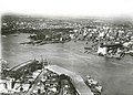 View towards Circular Quay, from the North Shore, c. 1930
 -
 The central business district features heritage conservation for historic buildings, such as the former Burns Philp Building on Bridge Street.
 -
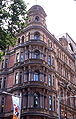 19th century York Street apartment building
 -
 The QVB at night
 -
 The CBD skyline illuminated at dusk from Cremorne Point
 -
 Sydney city at sunrise. This photo is taken from Bondi Junction, New South Wales
 -
 Scots Presbyterian Church, York Street
 -
 The western side of the CBD, Barangaroo is pictured.


.jpg)


.jpg)

See also
References
- ^ a b c d e f g h i Australian Bureau of Statistics (27 June 2017). "Sydney (State Suburb)". 2016 Census QuickStats. Retrieved 28 June 2017.
- ^ "CBD and Harbour". City Of Sydney. 2012.
- ^ "Australia's economic activity heavily concentrated in Sydney and Melbourne". taxpayer.com.au. 21 August 2014. Archived from the original on 1 April 2015. Retrieved 31 March 2015.
- ^ Australian Bureau of Statistics (28 June 2022). "Sydney Central Business District (suburb and locality)". Australian Census 2021. Retrieved 20 August 2022.
- ^ NSW GNB - Sydney (suburb)
- ^ Detailed Suburb Report for Sydney, Microburbs
- ^ Sydney - About the profile areas, ID.com.au
- ^ Attenbrow, Val (2010). Sydney's Aboriginal Past: Investigating the Archaeological and Historical Records. Sydney: UNSW Press. pp. 152–153. ISBN 978-1-74223-116-7. Retrieved 11 November 2013.
- ^ Macey, Richard (2007). "Settlers' history rewritten: go back 30,000 years". The Sydney Morning Herald. Retrieved 5 July 2014.
- ^ "Cook's landing site". Department of the Environment. 2014. Retrieved 5 July 2014.
- ^ "Geographical Names Register Extract - Sydney". Place Name Search. Geographical Names Board of New South Wales. Retrieved 25 April 2019.
- ^ Peter Hill (2008) p.141-150
- ^ "Archived copy". Archived from the original on 3 February 2013. Retrieved 14 July 2011.
{{cite web}}: CS1 maint: archived copy as title (link) - ^ "Aboriginal People of the Sydney Region". Australian Association of Bush Regenerators. Retrieved 11 May 2013.
- ^ "Archived copy". Archived from the original on 6 March 2011. Retrieved 17 February 2011.
{{cite web}}: CS1 maint: archived copy as title (link) - ^ "AEC redirection page".
- ^ http://www.qvb.com.au/About-QVB
- ^ SYDNEY FEMALE REFUGE SOCIETY. (8 March 1864). Empire (Sydney, NSW : 1850 – 1875), p. 5. Retrieved 5 February 2019
- ^ http://www.artgallery.nsw.gov.au/aboutus/history
- ^ http://www.dictionaryofsydney.org/entry/artists_camps
- ^ "The Central Station Riots of 1916". History of Sydney.
- ^ "Home". City of Sydney. Archived from the original on 19 February 2011. Retrieved 6 April 2013.
- ^ "Australia Archived 16 February 2017 at the Wayback Machine." ABN Amro. Retrieved 15 February 2017.
- ^ "Contact Us Archived 13 October 2012 at the Wayback Machine." Bloomsbury Publishing. Retrieved 14 October 2012. "Bloomsbury Publishing Pty Ltd. Level 14 309 Kent St Sydney NSW 2000 Australia"
- ^ Late night services Transport for NSW
- ^ "Churches". sydneyorgan.com. Archived from the original on 22 June 2015. Retrieved 22 June 2015.
- ^ Kaufman, Tina (May 2003). "Looking Back, Looking Forward: the Sydney Film Festival at 50". Senses of Cinema. 26. Senses of Cinema Inc. Archived from the original on 15 April 2005. Retrieved 25 April 2005.
- ^ "Sydney City". Destination New South Wales. Archived from the original on 9 April 2013. Retrieved 6 April 2013.
- ^ Lambert, Olivia (14 July 2016). "Sydney allows taller skyscrapers while Melbourne attempts to curb density". news.com.au. Retrieved 30 October 2020.
- ^ "Sydney's first skyscraper". State Library of New South Wales. Archived from the original on 11 January 2014. Retrieved 11 January 2014.
- ^ "Pyrmont Bridge". New South Wales State Heritage Register. Department of Planning & Environment. H01618. Retrieved 18 May 2018.
 Text is licensed by State of New South Wales (Department of Planning and Environment) under CC-BY 4.0 licence.
- ^ "Tank Stream". New South Wales State Heritage Register. Department of Planning & Environment. H00636. Retrieved 18 May 2018. Text is licensed by State of New South Wales (Department of Planning and Environment) under CC-BY 4.0 licence.
- ^ "Customs House (former)". New South Wales State Heritage Register. Department of Planning & Environment. H00727. Retrieved 18 May 2018. Text is licensed by State of New South Wales (Department of Planning and Environment) under CC-BY 4.0 licence.
- ^ "Pinnacle House". New South Wales State Heritage Register. Department of Planning & Environment. H00582. Retrieved 18 May 2018. Text is licensed by State of New South Wales (Department of Planning and Environment) under CC-BY 4.0 licence.
- ^ "Bank of NSW". New South Wales State Heritage Register. Department of Planning & Environment. H00080. Retrieved 18 May 2018. Text is licensed by State of New South Wales (Department of Planning and Environment) under CC-BY 4.0 licence.
- ^ "Cenotaph". New South Wales State Heritage Register. Department of Planning & Environment. H01799. Retrieved 18 May 2018. Text is licensed by State of New South Wales (Department of Planning and Environment) under CC-BY 4.0 licence.
- ^ "NSW Club House Building". New South Wales State Heritage Register. Department of Planning & Environment. H00145. Retrieved 18 May 2018. Text is licensed by State of New South Wales (Department of Planning and Environment) under CC-BY 4.0 licence.
- ^ "Burns Philp Building". New South Wales State Heritage Register. Department of Planning & Environment. H00347. Retrieved 18 May 2018. Text is licensed by State of New South Wales (Department of Planning and Environment) under CC-BY 4.0 licence.
- ^ "Liner House". New South Wales State Heritage Register. Department of Planning & Environment. H00589. Retrieved 18 May 2018. Text is licensed by State of New South Wales (Department of Planning and Environment) under CC-BY 4.0 licence.
- ^ "Lands Department Building". New South Wales State Heritage Register. Department of Planning & Environment. H00744. Retrieved 18 May 2018. Text is licensed by State of New South Wales (Department of Planning and Environment) under CC-BY 4.0 licence.
- ^ "Department of Education Building". New South Wales State Heritage Register. Department of Planning & Environment. H00726. Retrieved 18 May 2018. Text is licensed by State of New South Wales (Department of Planning and Environment) under CC-BY 4.0 licence.
- ^ "First Government House Site". New South Wales State Heritage Register. Department of Planning & Environment. H01309. Retrieved 18 May 2018. Text is licensed by State of New South Wales (Department of Planning and Environment) under CC-BY 4.0 licence.
- ^ "Bulletin Place Restaurant". New South Wales State Heritage Register. Department of Planning & Environment. H00651. Retrieved 18 May 2018. Text is licensed by State of New South Wales (Department of Planning and Environment) under CC-BY 4.0 licence.
- ^ "Building". New South Wales State Heritage Register. Department of Planning & Environment. H00652. Retrieved 18 May 2018. Text is licensed by State of New South Wales (Department of Planning and Environment) under CC-BY 4.0 licence.
- ^ "Warehouse (former)". New South Wales State Heritage Register. Department of Planning & Environment. H00653. Retrieved 18 May 2018. Text is licensed by State of New South Wales (Department of Planning and Environment) under CC-BY 4.0 licence.
- ^ "Capitol Theatre". New South Wales State Heritage Register. Department of Planning & Environment. H00391. Retrieved 18 May 2018. Text is licensed by State of New South Wales (Department of Planning and Environment) under CC-BY 4.0 licence.
- ^ "Trust Building". New South Wales State Heritage Register. Department of Planning & Environment. H00676. Retrieved 18 May 2018. Text is licensed by State of New South Wales (Department of Planning and Environment) under CC-BY 4.0 licence.
- ^ "Sydney Downing Centre". New South Wales State Heritage Register. Department of Planning & Environment. H00393. Retrieved 18 May 2018. Text is licensed by State of New South Wales (Department of Planning and Environment) under CC-BY 4.0 licence.
- ^ "Museum Railway Station". New South Wales State Heritage Register. Department of Planning & Environment. H01207. Retrieved 18 May 2018. Text is licensed by State of New South Wales (Department of Planning and Environment) under CC-BY 4.0 licence.
- ^ "St. James Railway Station group". New South Wales State Heritage Register. Department of Planning & Environment. H01248. Retrieved 18 May 2018. Text is licensed by State of New South Wales (Department of Planning and Environment) under CC-BY 4.0 licence.
- ^ "Red Cross House". New South Wales State Heritage Register. Department of Planning & Environment. H01511. Retrieved 18 May 2018. Text is licensed by State of New South Wales (Department of Planning and Environment) under CC-BY 4.0 licence.
- ^ "Police Station (former)". New South Wales State Heritage Register. Department of Planning & Environment. H00293. Retrieved 18 May 2018. Text is licensed by State of New South Wales (Department of Planning and Environment) under CC-BY 4.0 licence.
- ^ "St. Mary's Catholic Cathedral and Chapter House". New South Wales State Heritage Register. Department of Planning & Environment. H01709. Retrieved 18 May 2018. Text is licensed by State of New South Wales (Department of Planning and Environment) under CC-BY 4.0 licence.
- ^ "Australian Museum". New South Wales State Heritage Register. Department of Planning & Environment. H00805. Retrieved 18 May 2018. Text is licensed by State of New South Wales (Department of Planning and Environment) under CC-BY 4.0 licence.
- ^ "Carousel, The". New South Wales State Heritage Register. Department of Planning & Environment. H01620. Retrieved 18 May 2018. Text is licensed by State of New South Wales (Department of Planning and Environment) under CC-BY 4.0 licence.
- ^ "Railway Square road overbridge". New South Wales State Heritage Register. Department of Planning & Environment. H01232. Retrieved 18 May 2018. Text is licensed by State of New South Wales (Department of Planning and Environment) under CC-BY 4.0 licence.
- ^ "Martin Place Railway Station". New South Wales State Heritage Register. Department of Planning & Environment. H01187. Retrieved 18 May 2018. Text is licensed by State of New South Wales (Department of Planning and Environment) under CC-BY 4.0 licence.
- ^ "Sewer Vent". New South Wales State Heritage Register. Department of Planning & Environment. H01642. Retrieved 18 May 2018. Text is licensed by State of New South Wales (Department of Planning and Environment) under CC-BY 4.0 licence.
- ^ "GIO Building". New South Wales State Heritage Register. Department of Planning & Environment. H00683. Retrieved 18 May 2018. Text is licensed by State of New South Wales (Department of Planning and Environment) under CC-BY 4.0 licence.
- ^ "Cyprus-Hellene Club". New South Wales State Heritage Register. Department of Planning & Environment. H00773. Retrieved 18 May 2018. Text is licensed by State of New South Wales (Department of Planning and Environment) under CC-BY 4.0 licence.
- ^ "Cyprus Hellene Club - Australian Hall (Place ID 105937)". Australian Heritage Database. Australian Government. Retrieved 13 October 2018.
- ^ "Metters Building". New South Wales State Heritage Register. Department of Planning & Environment. H00732. Retrieved 18 May 2018. Text is licensed by State of New South Wales (Department of Planning and Environment) under CC-BY 4.0 licence.
- ^ "Crown Hotel". New South Wales State Heritage Register. Department of Planning & Environment. H00733. Retrieved 18 May 2018. Text is licensed by State of New South Wales (Department of Planning and Environment) under CC-BY 4.0 licence.
- ^ "Great Synagogue". New South Wales State Heritage Register. Department of Planning & Environment. H01710. Retrieved 18 May 2018. Text is licensed by State of New South Wales (Department of Planning and Environment) under CC-BY 4.0 licence.
- ^ "Sharpies Golf House Sign (The Golf House)". New South Wales State Heritage Register. Department of Planning & Environment. H01655. Retrieved 18 May 2018. Text is licensed by State of New South Wales (Department of Planning and Environment) under CC-BY 4.0 licence.
- ^ "Old Registry Office, Sydney Supreme Court House". New South Wales State Heritage Register. Department of Planning & Environment. H00801. Retrieved 18 May 2018. Text is licensed by State of New South Wales (Department of Planning and Environment) under CC-BY 4.0 licence.
- ^ "Hyde Park". New South Wales State Heritage Register. Department of Planning & Environment. H01871. Retrieved 18 May 2018. Text is licensed by State of New South Wales (Department of Planning and Environment) under CC-BY 4.0 licence.
- ^ "Watch House Terrace". New South Wales State Heritage Register. Department of Planning & Environment. H00223. Retrieved 18 May 2018. Text is licensed by State of New South Wales (Department of Planning and Environment) under CC-BY 4.0 licence.
- ^ "Watch House". New South Wales State Heritage Register. Department of Planning & Environment. H00501. Retrieved 18 May 2018. Text is licensed by State of New South Wales (Department of Planning and Environment) under CC-BY 4.0 licence.
- ^ "Royal Botanic Gardens and Domain". New South Wales State Heritage Register. Department of Planning & Environment. H01070. Retrieved 18 May 2018. Text is licensed by State of New South Wales (Department of Planning and Environment) under CC-BY 4.0 licence.
- ^ "Man O'War Steps". New South Wales State Heritage Register. Department of Planning & Environment. H01432. Retrieved 18 May 2018. Text is licensed by State of New South Wales (Department of Planning and Environment) under CC-BY 4.0 licence.
- ^ "Metropolitan Hotel". New South Wales State Heritage Register. Department of Planning & Environment. H00663. Retrieved 18 May 2018. Text is licensed by State of New South Wales (Department of Planning and Environment) under CC-BY 4.0 licence.
- ^ "Skinners Family Hotel". New South Wales State Heritage Register. Department of Planning & Environment. H00584. Retrieved 18 May 2018. Text is licensed by State of New South Wales (Department of Planning and Environment) under CC-BY 4.0 licence.
- ^ "Westpac Bank". New South Wales State Heritage Register. Department of Planning & Environment. H00664. Retrieved 18 May 2018. Text is licensed by State of New South Wales (Department of Planning and Environment) under CC-BY 4.0 licence.
- ^ "CBC Bank (former)". New South Wales State Heritage Register. Department of Planning & Environment. H00428. Retrieved 18 May 2018. Text is licensed by State of New South Wales (Department of Planning and Environment) under CC-BY 4.0 licence.
- ^ "National Mutual Building (former)". New South Wales State Heritage Register. Department of Planning & Environment. H00234. Retrieved 18 May 2018. Text is licensed by State of New South Wales (Department of Planning and Environment) under CC-BY 4.0 licence.
- ^ "ANZ Bank (former)". New South Wales State Heritage Register. Department of Planning & Environment. H00085. Retrieved 18 May 2018. Text is licensed by State of New South Wales (Department of Planning and Environment) under CC-BY 4.0 licence.
- ^ "Queen Victoria Building". New South Wales State Heritage Register. Department of Planning & Environment. H01814. Retrieved 18 May 2018. Text is licensed by State of New South Wales (Department of Planning and Environment) under CC-BY 4.0 licence.
- ^ "Sydney Town Hall". New South Wales State Heritage Register. Department of Planning & Environment. H01452. Retrieved 18 May 2018. Text is licensed by State of New South Wales (Department of Planning and Environment) under CC-BY 4.0 licence.
- ^ "King George Hotel (former) and Haymarket Post Office". New South Wales State Heritage Register. Department of Planning & Environment. H00615. Retrieved 18 May 2018. Text is licensed by State of New South Wales (Department of Planning and Environment) under CC-BY 4.0 licence.
- ^ "Christ Church St Laurence Anglican Church and Pipe Organ". New South Wales State Heritage Register. Department of Planning & Environment. H00123. Retrieved 18 May 2018. Text is licensed by State of New South Wales (Department of Planning and Environment) under CC-BY 4.0 licence.
- ^ "St. Andrew's Anglican Cathedral and Chapter House". New South Wales State Heritage Register. Department of Planning & Environment. H01708. Retrieved 18 May 2018. Text is licensed by State of New South Wales (Department of Planning and Environment) under CC-BY 4.0 licence.
- ^ "Sydney Trades Hall". New South Wales State Heritage Register. Department of Planning & Environment. H00322. Retrieved 18 May 2018. Text is licensed by State of New South Wales (Department of Planning and Environment) under CC-BY 4.0 licence.
- ^ "Sydney Terminal and Central Railway Stations Group". New South Wales State Heritage Register. Department of Planning & Environment. H01255. Retrieved 18 May 2018. Text is licensed by State of New South Wales (Department of Planning and Environment) under CC-BY 4.0 licence.
- ^ "Chinese Garden of Friendship". New South Wales State Heritage Register. Department of Planning & Environment. H02017. Retrieved 26 December 2019. Text is licensed by State of New South Wales (Department of Planning and Environment) under CC-BY 4.0 licence.
- ^ "Municipal Building". New South Wales State Heritage Register. Department of Planning & Environment. H00693. Retrieved 18 May 2018. Text is licensed by State of New South Wales (Department of Planning and Environment) under CC-BY 4.0 licence.
- ^ "Perpetual Trustee Company". New South Wales State Heritage Register. Department of Planning & Environment. H00678. Retrieved 18 May 2018. Text is licensed by State of New South Wales (Department of Planning and Environment) under CC-BY 4.0 licence.
- ^ "City Mutual Life Assurance Building". New South Wales State Heritage Register. Department of Planning & Environment. H00585. Retrieved 18 May 2018. Text is licensed by State of New South Wales (Department of Planning and Environment) under CC-BY 4.0 licence.
- ^ "Qantas House (No. 1 Chifley Square)". New South Wales State Heritage Register. Department of Planning & Environment. H01512. Retrieved 18 May 2018. Text is licensed by State of New South Wales (Department of Planning and Environment) under CC-BY 4.0 licence.
- ^ "ANZAC Memorial". New South Wales State Heritage Register. Department of Planning & Environment. H01822. Retrieved 18 May 2018. Text is licensed by State of New South Wales (Department of Planning and Environment) under CC-BY 4.0 licence.
- ^ "HMAS Sydney 1 - SMS Emden Memorial (moveable heritage item)". New South Wales State Heritage Register. Department of Planning & Environment. H01946. Retrieved 18 May 2018. Text is licensed by State of New South Wales (Department of Planning and Environment) under CC-BY 4.0 licence.
- ^ "Judges House, The". New South Wales State Heritage Register. Department of Planning & Environment. H00060. Retrieved 18 May 2018. Text is licensed by State of New South Wales (Department of Planning and Environment) under CC-BY 4.0 licence.
- ^ "Sydney Supreme Court House (Old Court House)". New South Wales State Heritage Register. Department of Planning & Environment. H00800. Retrieved 18 May 2018. Text is licensed by State of New South Wales (Department of Planning and Environment) under CC-BY 4.0 licence.
- ^ "St. James' Anglican Church". New South Wales State Heritage Register. Department of Planning & Environment. H01703. Retrieved 18 May 2018. Text is licensed by State of New South Wales (Department of Planning and Environment) under CC-BY 4.0 licence.
- ^ "Post Office Stores". New South Wales State Heritage Register. Department of Planning & Environment. H00608. Retrieved 18 May 2018. Text is licensed by State of New South Wales (Department of Planning and Environment) under CC-BY 4.0 licence.
- ^ "Little Hunter and Hamilton Street Precinct". New South Wales State Heritage Register. Department of Planning & Environment. H00599. Retrieved 18 May 2018. Text is licensed by State of New South Wales (Department of Planning and Environment) under CC-BY 4.0 licence.
- ^ "Sydney Central Local Court House". New South Wales State Heritage Register. Department of Planning & Environment. H00802. Retrieved 18 May 2018. Text is licensed by State of New South Wales (Department of Planning and Environment) under CC-BY 4.0 licence.
- ^ "Macquarie Place Precinct". New South Wales State Heritage Register. Department of Planning & Environment. H01759. Retrieved 18 May 2018. Text is licensed by State of New South Wales (Department of Planning and Environment) under CC-BY 4.0 licence.
- ^ "Kyle House". New South Wales State Heritage Register. Department of Planning & Environment. H00654. Retrieved 18 May 2018. Text is licensed by State of New South Wales (Department of Planning and Environment) under CC-BY 4.0 licence.
- ^ "Mint Building and Hyde Park Barracks Group". New South Wales State Heritage Register. Department of Planning & Environment. H00190. Retrieved 18 May 2018. Text is licensed by State of New South Wales (Department of Planning and Environment) under CC-BY 4.0 licence.
- ^ "Parliament House". New South Wales State Heritage Register. Department of Planning & Environment. H01615. Retrieved 18 May 2018. Text is licensed by State of New South Wales (Department of Planning and Environment) under CC-BY 4.0 licence.
- ^ "Conservatorium of Music". New South Wales State Heritage Register. Department of Planning & Environment. H01849. Retrieved 18 May 2018. Text is licensed by State of New South Wales (Department of Planning and Environment) under CC-BY 4.0 licence.
- ^ "Royal Automobile Club". New South Wales State Heritage Register. Department of Planning & Environment. H00700. Retrieved 18 May 2018. Text is licensed by State of New South Wales (Department of Planning and Environment) under CC-BY 4.0 licence.
- ^ "Health Department Building (former)". New South Wales State Heritage Register. Department of Planning & Environment. H01912. Retrieved 18 May 2018. Text is licensed by State of New South Wales (Department of Planning and Environment) under CC-BY 4.0 licence.
- ^ "Intercontinental Hotel former Treasury Building". New South Wales State Heritage Register. Department of Planning & Environment. H00355. Retrieved 18 May 2018. Text is licensed by State of New South Wales (Department of Planning and Environment) under CC-BY 4.0 licence.
- ^ "Chief Secretary's Building". New South Wales State Heritage Register. Department of Planning & Environment. H00766. Retrieved 18 May 2018. Text is licensed by State of New South Wales (Department of Planning and Environment) under CC-BY 4.0 licence.
- ^ "History House". New South Wales State Heritage Register. Department of Planning & Environment. H00692. Retrieved 18 May 2018. Text is licensed by State of New South Wales (Department of Planning and Environment) under CC-BY 4.0 licence.
- ^ "BMA House". New South Wales State Heritage Register. Department of Planning & Environment. H00252. Retrieved 18 May 2018. Text is licensed by State of New South Wales (Department of Planning and Environment) under CC-BY 4.0 licence.
- ^ "St. Stephen's Uniting Church". New South Wales State Heritage Register. Department of Planning & Environment. H01704. Retrieved 18 May 2018. Text is licensed by State of New South Wales (Department of Planning and Environment) under CC-BY 4.0 licence.
- ^ "Government House, Movable Heritage Collection and Gardens". New South Wales State Heritage Register. Department of Planning & Environment. H01872. Retrieved 18 May 2018. Text is licensed by State of New South Wales (Department of Planning and Environment) under CC-BY 4.0 licence.
- ^ "State Theatre". New South Wales State Heritage Register. Department of Planning & Environment. H00446. Retrieved 18 May 2018. Text is licensed by State of New South Wales (Department of Planning and Environment) under CC-BY 4.0 licence.
- ^ "General Post Office". New South Wales State Heritage Register. Department of Planning & Environment. H00763. Retrieved 18 May 2018. Text is licensed by State of New South Wales (Department of Planning and Environment) under CC-BY 4.0 licence.
- ^ "Challis House". New South Wales State Heritage Register. Department of Planning & Environment. H00666. Retrieved 18 May 2018. Text is licensed by State of New South Wales (Department of Planning and Environment) under CC-BY 4.0 licence.
- ^ "MLC Building (Former)". New South Wales State Heritage Register. Department of Planning & Environment. H00597. Retrieved 18 May 2018. Text is licensed by State of New South Wales (Department of Planning and Environment) under CC-BY 4.0 licence.
- ^ "Commonwealth Bank". New South Wales State Heritage Register. Department of Planning & Environment. H01427. Retrieved 18 May 2018. Text is licensed by State of New South Wales (Department of Planning and Environment) under CC-BY 4.0 licence.
- ^ "APA Building". New South Wales State Heritage Register. Department of Planning & Environment. H00682. Retrieved 18 May 2018. Text is licensed by State of New South Wales (Department of Planning and Environment) under CC-BY 4.0 licence.
- ^ "Public Trust Office". New South Wales State Heritage Register. Department of Planning & Environment. H01019. Retrieved 18 May 2018. Text is licensed by State of New South Wales (Department of Planning and Environment) under CC-BY 4.0 licence.
- ^ "Justice and Police Museum". New South Wales State Heritage Register. Department of Planning & Environment. H00673. Retrieved 18 May 2018. Text is licensed by State of New South Wales (Department of Planning and Environment) under CC-BY 4.0 licence.
- ^ "Phillip Street Terraces". New South Wales State Heritage Register. Department of Planning & Environment. H00621. Retrieved 18 May 2018. Text is licensed by State of New South Wales (Department of Planning and Environment) under CC-BY 4.0 licence.
- ^ "Wales House". New South Wales State Heritage Register. Department of Planning & Environment. H00586. Retrieved 18 May 2018. Text is licensed by State of New South Wales (Department of Planning and Environment) under CC-BY 4.0 licence.
- ^ "Sydney Club". New South Wales State Heritage Register. Department of Planning & Environment. H00583. Retrieved 18 May 2018. Text is licensed by State of New South Wales (Department of Planning and Environment) under CC-BY 4.0 licence.
- ^ "Sugar House". New South Wales State Heritage Register. Department of Planning & Environment. H00417. Retrieved 18 May 2018. Text is licensed by State of New South Wales (Department of Planning and Environment) under CC-BY 4.0 licence.
- ^ "Grahame's Corner". New South Wales State Heritage Register. Department of Planning & Environment. H00736. Retrieved 18 May 2018. Text is licensed by State of New South Wales (Department of Planning and Environment) under CC-BY 4.0 licence.
- ^ "Strand Arcade". New South Wales State Heritage Register. Department of Planning & Environment. H01864. Retrieved 18 May 2018. Text is licensed by State of New South Wales (Department of Planning and Environment) under CC-BY 4.0 licence.
- ^ "Pitt Street Uniting Church". New South Wales State Heritage Register. Department of Planning & Environment. H00022. Retrieved 18 May 2018. Text is licensed by State of New South Wales (Department of Planning and Environment) under CC-BY 4.0 licence.
- ^ "Sydney School of Arts". New South Wales State Heritage Register. Department of Planning & Environment. H00366. Retrieved 18 May 2018. Text is licensed by State of New South Wales (Department of Planning and Environment) under CC-BY 4.0 licence.
- ^ "Sydney Water Head Office (former) (1939 building)". New South Wales State Heritage Register. Department of Planning & Environment. H01645. Retrieved 18 May 2018. Text is licensed by State of New South Wales (Department of Planning and Environment) under CC-BY 4.0 licence.
- ^ "Land Titles Office". New South Wales State Heritage Register. Department of Planning & Environment. H00962. Retrieved 18 May 2018. Text is licensed by State of New South Wales (Department of Planning and Environment) under CC-BY 4.0 licence.
- ^ "State Library of NSW". New South Wales State Heritage Register. Department of Planning & Environment. H01071. Retrieved 18 May 2018. Text is licensed by State of New South Wales (Department of Planning and Environment) under CC-BY 4.0 licence.
- ^ "Banco Road Court, Sydney Supreme Court House". New South Wales State Heritage Register. Department of Planning & Environment. H00799. Retrieved 18 May 2018. Text is licensed by State of New South Wales (Department of Planning and Environment) under CC-BY 4.0 licence.
- ^ "Big House Hotel". New South Wales State Heritage Register. Department of Planning & Environment. H00513. Retrieved 18 May 2018. Text is licensed by State of New South Wales (Department of Planning and Environment) under CC-BY 4.0 licence.
- ^ "Welcome Inn Hotel". New South Wales State Heritage Register. Department of Planning & Environment. H00408. Retrieved 18 May 2018. Text is licensed by State of New South Wales (Department of Planning and Environment) under CC-BY 4.0 licence.
- ^ "Hawker & Vance Produce Exchange". New South Wales State Heritage Register. Department of Planning & Environment. H00409. Retrieved 18 May 2018. Text is licensed by State of New South Wales (Department of Planning and Environment) under CC-BY 4.0 licence.
- ^ "Royal George Hotel". New South Wales State Heritage Register. Department of Planning & Environment. H00411. Retrieved 18 May 2018. Text is licensed by State of New South Wales (Department of Planning and Environment) under CC-BY 4.0 licence.
- ^ "Building". New South Wales State Heritage Register. Department of Planning & Environment. H00410. Retrieved 18 May 2018. Text is licensed by State of New South Wales (Department of Planning and Environment) under CC-BY 4.0 licence.
- ^ "Building". New South Wales State Heritage Register. Department of Planning & Environment. H00412. Retrieved 18 May 2018. Text is licensed by State of New South Wales (Department of Planning and Environment) under CC-BY 4.0 licence.
- ^ "Warehouses (former)". New South Wales State Heritage Register. Department of Planning & Environment. H00413. Retrieved 18 May 2018. Text is licensed by State of New South Wales (Department of Planning and Environment) under CC-BY 4.0 licence.
- ^ "Building". New South Wales State Heritage Register. Department of Planning & Environment. H00414. Retrieved 18 May 2018. Text is licensed by State of New South Wales (Department of Planning and Environment) under CC-BY 4.0 licence.
- ^ "Terrace Houses". New South Wales State Heritage Register. Department of Planning & Environment. H00415. Retrieved 18 May 2018. Text is licensed by State of New South Wales (Department of Planning and Environment) under CC-BY 4.0 licence.
- ^ "Dundee Arms Hotel". New South Wales State Heritage Register. Department of Planning & Environment. H00416. Retrieved 18 May 2018. Text is licensed by State of New South Wales (Department of Planning and Environment) under CC-BY 4.0 licence.
- ^ "Corn Exchange". New South Wales State Heritage Register. Department of Planning & Environment. H01619. Retrieved 18 May 2018. Text is licensed by State of New South Wales (Department of Planning and Environment) under CC-BY 4.0 licence.
- ^ "International House". New South Wales State Heritage Register. Department of Planning & Environment. H00579. Retrieved 18 May 2018. Text is licensed by State of New South Wales (Department of Planning and Environment) under CC-BY 4.0 licence.
- ^ "Transport House". New South Wales State Heritage Register. Department of Planning & Environment. H01271. Retrieved 18 May 2018. Text is licensed by State of New South Wales (Department of Planning and Environment) under CC-BY 4.0 licence.
- ^ "Warehouse (former)". New South Wales State Heritage Register. Department of Planning & Environment. H00647. Retrieved 18 May 2018. Text is licensed by State of New South Wales (Department of Planning and Environment) under CC-BY 4.0 licence.
- ^ "AWA Building and Tower". New South Wales State Heritage Register. Department of Planning & Environment. H00665. Retrieved 18 May 2018. Text is licensed by State of New South Wales (Department of Planning and Environment) under CC-BY 4.0 licence.
- ^ "Hardware House". New South Wales State Heritage Register. Department of Planning & Environment. H00580. Retrieved 18 May 2018. Text is licensed by State of New South Wales (Department of Planning and Environment) under CC-BY 4.0 licence.
- ^ "National House". New South Wales State Heritage Register. Department of Planning & Environment. H00581. Retrieved 18 May 2018. Text is licensed by State of New South Wales (Department of Planning and Environment) under CC-BY 4.0 licence.
- ^ "Grace Building". New South Wales State Heritage Register. Department of Planning & Environment. H00712. Retrieved 18 May 2018. Text is licensed by State of New South Wales (Department of Planning and Environment) under CC-BY 4.0 licence.
- ^ "Gresham Hotel". New South Wales State Heritage Register. Department of Planning & Environment. H00291. Retrieved 18 May 2018. Text is licensed by State of New South Wales (Department of Planning and Environment) under CC-BY 4.0 licence.
- ^ "Ozanam House". New South Wales State Heritage Register. Department of Planning & Environment. H00701. Retrieved 18 May 2018. Text is licensed by State of New South Wales (Department of Planning and Environment) under CC-BY 4.0 licence.
- ^ "Young Street Terraces". New South Wales State Heritage Register. Department of Planning & Environment. H00974. Retrieved 18 May 2018. Text is licensed by State of New South Wales (Department of Planning and Environment) under CC-BY 4.0 licence.
External links
 Media related to Central Business District, Sydney at Wikimedia Commons