Burstall, Saskatchewan
Appearance
Burstall, Saskatchewan | |
|---|---|
Town | |
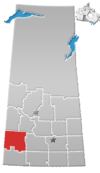
Location of Burstall in Saskatchewan | |
| Coordinates: 50°39′20″N 109°54′33″W / 50.65547°N 109.90924°W | |
| Country | Canada |
| Province | Saskatchewan |
| Region | South west, Saskatchewan |
| Census division | Division No. 8 |
| Area | |
| • Total | 1.1148 km2 (0.4304 sq mi) |
| Population (2001) | |
| • Total | 300 |
| Postal code | S0N 0H0 |
| Area code | 306 |
Burstall is a small town in southwestern Saskatchewan, Canada with a population of approximately 500. During summer the local Lions Club organizes an activity known as Summer Slam. The main economies in the area are natural gas as well as wheat and cattle farming. The area was originally settled by Germans, mostly Lutherans from South Russia. Starting in around 1978, the town committee began a calendar that has everyone's birthday, anniversary and passing noted for each day.
See also
50°39′N 109°55′W / 50.650°N 109.917°W
References


