GOES 15
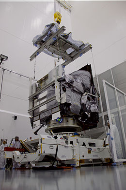
 GOES 15 during pre-launch processing | |
| Mission type | Weather satellite |
|---|---|
| Operator | NOAA / NASA |
| COSPAR ID | 2010-008A |
| SATCAT no. | 36411 |
| Mission duration | 10 years (planned) |
| Spacecraft properties | |
| Spacecraft type | GOES-N series |
| Bus | BSS-601 |
| Manufacturer | Boeing ITT Corporation |
| Power | 2.3 kilowatts from solar array |
| Start of mission | |
| Launch date | 4 March 2010, 23:57 UTC |
| Rocket | Delta IV-M+(4,2) |
| Launch site | Cape Canaveral SLC-37B |
| Contractor | United Launch Alliance |
| Orbital parameters | |
| Reference system | Geocentric |
| Regime | Geostationary |
| Longitude | 135° West |
| Slot | GOES-WEST |
| Semi-major axis | 42,166 kilometres (26,201 mi) |
| Perigee altitude | 35,791.0 kilometres (22,239.5 mi) |
| Apogee altitude | 35,800.4 kilometres (22,245.3 mi) |
| Inclination | 0.2º |
| Period | 1,436.2 minutes |

GOES 15, previously known as GOES-P, is an American weather satellite, which forms part of the Geostationary Operational Environmental Satellite (GOES) system operated by the U.S. National Oceanic and Atmospheric Administration. The spacecraft was constructed by Boeing, and is the last of three GOES satellites to be based on the BSS-601 bus. The other BSS-601 GOES satellites; GOES 13 and GOES 14 were launched in May 2006 and June 2009 respectively.[1] In total it was the sixteenth GOES satellite to be launched.
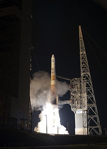
GOES 15 was launched atop a Delta IV-M+(4,2) rocket flying from Space Launch Complex 37B at the Cape Canaveral Air Force Station.[2][3] The launch occurred at 23:57 GMT on 4 March 2010, forty minutes into a sixty-minute launch window. Upon reaching geostationary orbit on 16 March, it was redesignated GOES 15.[3][4] On December 6, 2011, it was activated as the GOES West satellite, replacing GOES 11.[5]
At launch, the mass of the satellite was 3,238 kilograms (7,139 lb). It has a design life of ten years. Power is supplied by a single gallium arsenide solar panel, which provides up to 2.3 kilowatts of power. A 24 cell nickel hydrogen battery is used to provide power when the satellite is not in sunlight.[6] Instruments aboard GOES15 include a five channel multispectral imager to capture visible light and infrared images of the continental United States, a sounder to take readings of atmospheric temperature and moisture, a solar x-ray imager to detect solar flares, and instruments to monitor the magnetosphere, cosmic background radiation and charged particles.[6]
Media
References
- ^ Krebs, Gunter. "GOES N, O, P, Q". Gunter's Space Page. Retrieved 4 March 2010.
- ^ "GOES-P Launch Blog". NASA. Retrieved 2010-03-04.
- ^ a b Ray, Justin. "Mission Status Center". Delta Launch Report. Spaceflight Now. Retrieved 19 March 2010.
- ^ "LIVE: Delta IV set to launch GOES-P weather satellite". NASAspaceflight.com. Retrieved 4 March 2010.
- ^ "NOAA activates GOES-15 satellite; deactivates GOES-11 after nearly 12 years in orbit". NOAA. Retrieved December 7, 2011.
- ^ a b "GOES-P Mission Operations Booklet" (PDF). United Launch Alliance. Retrieved 4 March 2010.
External links
- GOES-P Press Kit
- GOES Timeline The History of Geostationary Satellites. From the launch of SMS-1 in May 1974 through the launch of GOES-13.
- GOES-15 image examples on the CIMSS Satellite Blog

