Great Rann of Kutch


The Great Rann of Kutch is a seasonal salt marsh located in the Thar Desert in the Kutch District of Gujarat, India and the Sindh province of Pakistan. It is about 7,505.22 square kilometres (2,897.78 sq mi) in size and is reputed to be one of the largest salt deserts in the world.[1] This area has been inhabited by the Kutchi people.[2]
The name "Rann" comes from the Hindi word ran (रण) meaning "desert". The Hindi word is derived from Sanskrit/Vedic word iriṇa (इरिण) attested in the Rigveda and Mahābhārata. As early as 325 BCE, Alexander the Great was aware of the area.[3]
Location and description
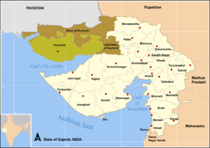
The Great Rann of Kutch, along with the Little Rann of Kutch and the Banni grasslands on its southern edge, is situated in the district of Kutch and comprises some 30,000 square kilometres (10,000 sq mi) between the Gulf of Kutch and the mouth of the Indus River in southern Pakistan. The marsh can be accessed from the village of Kharaghoda in Surendranagar District.[4]
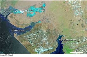
In India's summer monsoon, the flat desert of salty clay and mudflats, which average 15 meters above sea level, fills with standing water. In very wet years, the wetland extends from the Gulf of Kutch on the west through to the Gulf of Cambay on the east.[5]
The area was a vast shallow of the Arabian Sea until continuing geological uplift closed off the connection with the sea, creating a vast lake that was still navigable during the time of Alexander the Great. The Ghaggar River, which presently empties into the desert of northern Rajasthan, formerly emptied into the Rann of Kutch, but the lower reaches of the river dried up as its upstream tributaries were captured by the Indus and Ganges thousands of years ago. Traces of the delta and its distributary channels on the northern boundary of the Rann of Kutch were documented by the Geological Survey of India in 2000.
The Luni River, which originates in Rajasthan, drains into the desert in the northeast corner of the Rann. Other rivers feeding into the marsh include the Rupen from the east and the West Banas River from the northeast.[6]
There are sandy islets of thorny scrub, forming a wildlife sanctuary[6] and a breeding ground for some of the largest flocks of greater and lesser flamingos. Wildlife, including the Indian wild ass, shelter on islands of higher ground, called bets, during the flooding.
Climate
This is one of the hottest areas of India - with summer temperatures averaging and peaking at 49.5 °C. Winter temperatures reduce dramatically and can go below 0 °C (32 °F).[7]
Religions
Many religions are found here, including Hinduism, Islam, Jainism & Sikhism.
Threats and preservation
Although most of the marsh is in protected areas, the habitats are vulnerable to cattle grazing, firewood collection and salt extraction operations, all of which may involve transportation that disturbs wildlife. There are several wildlife sanctuaries and protected reserves on the Indian side in the Rann of Kutch region. From the city of Bhuj, various ecologically rich and wildlife conservation areas of the Kutch/Kachchh district can be visited such as Indian Wild Ass Sanctuary, Kutch Desert Wildlife Sanctuary, Narayan Sarovar Sanctuary, Kutch Bustard Sanctuary, Banni Grasslands Reserve and Chari-Dhand Wetland Conservation Reserve.
Indo-Pakistan international border

In India the northern boundary of the Greater Rann of Kutch forms the International Border between India and Pakistan, it is heavily patrolled by India's Border Security Force (BSF) and Indian Army conducts exercises here to acclimatize its troops to this harsh terrain.[8]
This inhospitable salty lowland, rich in natural gas, was one scene of perennial border disputes between India and Pakistan that, in April 1965, contributed to the Indo-Pakistani War of 1965. Later the same year, Prime Minister of the United Kingdom Harold Wilson persuaded the combatants to end hostilities and establish a tribunal to resolve the dispute. A verdict was reached in 1968 which saw Pakistan getting 10% of its claim of 9,100 square kilometres (3,500 sq mi). 90% was awarded to India, although India claimed 100% of the region. Tensions spurted again in 1999 during the Atlantique Incident.[9]
Indus river floods
The Indus river had been flowing in to Rann of Kutch area and Rann of Kutch used to be its catchment area forming part of its delta.[10][11] Indus river branch called Koree river, shifted its course after an earthquake in 1819 isolating Rann of Kutch from its delta.[12] Pakistan has constructed Left Bank Outfall Drain (LBOD) project to bypass the saline and polluted water which is not fit for agriculture use to reach sea via Rann of Kutch area without passing through the Indus delta.[13] The 500 km long LBOD, begins from northern Ghotki district in Sindh province of Pakistan and joins Rann of Kutch in Badin district of Sindh.[14] Rann of Kutch is joint water body of India and Pakistan.[15] Water released by the LBOD is enhancing the flooding in India and contaminating the quality of water bodies which are source of water to salt farms spread over vast area. The LBOD water is planned to join the sea via disputed Sir Creek but LBOD water is entering Indian territory due to many breaches in its left bank caused by floods[16]
Chir Batti
At night, an unexplained strange dancing light phenomena known locally as Chir Batti (ghost lights) occurs in the Rann,[17][18][19] the adjoining Banni grasslands, and the seasonal wetlands.[20]
Tourism

The Government of Gujarat hosts an annual 3 month long festival during winter called the "Rann Utsav festival of the Rann" where tourists can see the various sights of the Rann. For 2016, rann utsav- starts from 1 November 2016.
Rann Utsav gives visitors not only a chance to experience full moon on salt deserts but also get a taste of the local culture, cuisine and hospitality. Specially built local houses are also used to house tourists to give them a taste of local traditions[21] Many adventure clubs and travel clubs organize expeditions.[22]
Handicrafts
The unique handicrafts of Kutch are world famous.[23] A lot of women and young girls make their living by selling different types of embroidered cloths. The embroidery is of various styles such as Rabari, Ahir, Sindhi, Banni, Mutwa, Ari and Soof - and some styles include mirror or bead inlay.

Popular culture
J. P. Dutta's Bollywood film Refugee was shot in the Great Rann of Kutch along with other locations in the Kachchh district. It is said to have been inspired from the story by Keki N. Daruwalla based around the Great Rann of Kutch titled Love Across the Salt Desert.[24][25][26][27][28][29][30]
Amitabh Bachchan in his promotions for Gujarat Tourism titled Khushboo Gujarat Ki has also extensively shot in the Rann of kutch.[31] Several scenes in Salman Rushdie's Booker Prize winning novel Midnight's Children take place in the Rann of Kutch, including a scene where the protagonist faints from heat stroke in the Rann's brutal climate. Some scenes or song sequences in Indian films like Magadheera, D-Day, R... Rajkumar, Gori Tere Pyaar Mein, Goliyon Ki Raasleela Ram-Leela, Lagaan, The Good Road and Dookudu, Sarrainoduwere shot in the area.[32]
See also
|
|
References
- ^ "Gujarat Tourism Document" (PDF). Gujarattourism.com. Retrieved 22 November 2013.
- ^ INTERNATIONAL LAW REPORTS VOLUME 50. Cambridge University Press. p. 464. ISBN 9780406876522.
- ^ "Cutch". The Imperial Gazetteer of India. 11: 77. 1908.
- ^ Negi, S.S. (1996). Biosphere reserves in India : landuse, biodiversity and conservation. New Delhi: Indus Pub. Co. ISBN 978-81-7387-043-9.
- ^ At its greatest extent, the Gulf of Kutch on the west (visible in the image directly below the salt marshes) and the Gulf of Cambay on the east (the brown, sediment-tinged body of water on the lower right) are both united during the monsoon. "Rann of Kutch, India". Earth Snapshot. 6 November 2008. p. 2. Retrieved 22 November 2013.
- ^ a b "Rann of Kutch seasonal salt marsh". Terrestrial Ecoregions. World Wildlife Fund.
- ^ "Encyclopaedia of Earth". Eoearth.org. Retrieved 22 November 2013.
- ^ "Cease Fire and After: Better Security in Western India". Link. 14 (2). New Delhi: United India Periodicals: 13. 1971.
- ^ 50 years of Indo-Pak relations - the initial phase : partition of India, Indo-Pak wars, the UNO. New Delhi: Deep & Deep Publ. 1998. ISBN 978-81-7629-057-9.
{{cite book}}:|first=has generic name (help);|first=missing|last=(help) - ^ "Two disasters that defined India's south-west border with Pakistan for ever". Retrieved 22 December 2015.
- ^ "Anthropocene Metamorphosis of the Indus Delta and Lower Floodplain" (PDF). Retrieved 22 December 2015.
- ^ "Indus re-enters India after two centuries, feeds Little Rann, Nal Sarovar". Retrieved 22 December 2015.
- ^ "Revisiting the LBOD issue". Retrieved 22 December 2015.
- ^ "Sindh floods: LBOD was a mistake, experts finally agree with residents". Retrieved 22 December 2015.
- ^ "LBOD the culprit behind recurring floods in Sindh". Retrieved 22 December 2015.
- ^ "Evolution of the Delta, the LBOD outfall system and the Badin dhands - chapters 3 & 4" (PDF). Retrieved 22 December 2015.
- ^ "INDIA TODAY GROUP: India Today, Business Today, Aaj Tak, Care Today, Mail Today, Cosmopolitan, Reader's Digest, India Today Conclave". Intoday.in. Retrieved 22 November 2013.
- ^ [1][dead link]
- ^ "In Today - Blogs, Photos, Videos, sports and Business". Archive.is. 3 August 2012. Archived from the original on 3 August 2012. Retrieved 22 November 2013.
{{cite web}}: Unknown parameter|deadurl=ignored (|url-status=suggested) (help) - ^ [2] Archived 14 January 2009 at the Wayback Machine
- ^ "Rann Utsav | Fairs & Festivals | Home". Gujarat Tourism. 13 November 2013. Retrieved 22 November 2013.
- ^ Rann Utasav web site
- ^ "Rann Utsav 2009 | Fairs & Festivals | Home". Gujarat Tourism. Retrieved 22 November 2013.
- ^ "LOVE ACROSS THE SALT DESERT - binaljavia". Learnhub.com. Retrieved 22 November 2013.
- ^ "Love across The Salt Desert" (PDF). Cns.bu.edu. Retrieved 23 November 2013.
- ^ "LOVE ACROSS THE SALT DESERT know more - binaljavia". Learnhub.com. Retrieved 22 November 2013.
- ^ [3] Archived 29 January 2011 at the Wayback Machine
- ^ "Google Drive Viewer". Docs.google.com. Retrieved 22 November 2013.
- ^ "Indian School Certificate (Year-12) : List of Prescribed Textbooks" (PDF). Web.archive.org. Archived from the original (PDF) on 22 November 2012. Retrieved 23 November 2013.
{{cite web}}: Unknown parameter|deadurl=ignored (|url-status=suggested) (help) - ^ [4] Archived 10 April 2009 at the Wayback Machine
- ^ "Akshar Travels khushboo gujarat ki..call us 1800 233 9008". YouTube. 27 August 2010. Retrieved 22 November 2013.
- ^ Mishra, Abhimanyu (26 September 2013). "The Rann of Kutch is emerging as the favourite with filmmakers". The Times of India. Retrieved 3 February 2014.
- World Wildlife Fund, ed. (2001). "Rann of Kutch seasonal salt marsh". WildWorld Ecoregion Profile. National Geographic Society. Archived from the original on 8 March 2010.
- This article incorporates text from a publication now in the public domain: Chisholm, Hugh, ed. (1911). Encyclopædia Britannica (11th ed.). Cambridge University Press.
{{cite encyclopedia}}: Missing or empty|title=(help)
External links
- Gujarat Tourism official website
- "World Wildlife Fund:". Terrestrial Ecoregions. World Wildlife Fund. Terrestrial Ecoregions: Rann of Kutch
- Satellite views comparing summer and winter conditions in the Rann of Kutch
- Desert (Rann of Kutch) wetlands; 6 February 2003; WWF Global website
- KACHCHH PENINSULA AND THE GREAT RANN; The Geological Survey of India, Ministry of Mines, Government of India
- Archived news articles from the India Environmental Portal on: Rann of Kutch
- Archived news articles from the India Environmental Portal for a Search made for: Banni grasslands[permanent dead link]
- Use dmy dates from July 2013
- Indomalaya ecozone
- Flooded grasslands and savannas
- Ecoregions of India
- Ecoregions of Asia
- Grasslands of Pakistan
- Ecoregions of Pakistan
- Territorial disputes of Pakistan
- Grasslands of India
- Landforms of Gujarat
- Landforms of Sindh
- Marshes of India
- Kutch district
- Ramsar sites in Pakistan
- Geography of Kutch district
