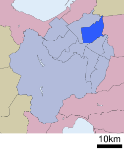
Higashi-ku, Sapporo
Higashi
東区 | |
|---|---|
| Higashi Ward | |
 Location of Higashi-ku in Sapporo | |
| Country | Japan |
| Prefecture | Hokkaidō |
| City | Sapporo |
| Established | April 1, 1972 |
| Area | |
| • Total | 56.97 km2 (22.00 sq mi) |
| Population (2021) | |
| • Total | 262,195 |
| • Density | 4,600/km2 (12,000/sq mi) |
| Estimation as of August 31, 2021 | |
| Time zone | UTC+9 (Japan Standard Time) |
| Postal | 065-8612 |
| Address | 7-1 Kita Juichijyo Higashi, Higashi-ku, Sapporo-shi, Hokkaido |
| Website | Higashi Ward Office |

Higashi-ku (東区) is one of the 10 wards in Sapporo, Hokkaidō, Japan. It is directly translated as "east ward", and is neighboured to Kita-ku, Chūō-ku, Shiroishi-ku, Ebetsu, Tōbetsu.
Overview
[edit]According to the 2008 registry of residential addresses, 254,360 people lived in Higashi-ku. It is 57.13 km2 in area, and a number of rivers are located in the ward including the Toyohira River.
The ward has a mascot character, Tappy, which was designed to be an onion-themed fairy; it was named in 1993, and is a portmanteau of "Tamanegi" (meaning onion in Japanese) and "happy".[1] The onion is a vegetable raised in Higashi-ku, and therefore Tappy is associated with onions.[1]
History
[edit]Originally, at the place where Higashi-ku is, Naebo Village and Okadama Village were established by pioneers in 1870. Sapporo Village was established in 1871, and Kariki Village was established in 1873. In 1902, Naebo Village, Okadama Village, and Kariki Village were merged into Sapporo Village, which covered nearly the same extent as the current Higashi-ku.[2]
In 1955, Sapporo Village was merged into Sapporo City. In 1972, Sapporo was listed as one of the cities designated by government ordinance,[2] which enabled Higashi-ku to be established. In 1988, the Tōhō line of the Sapporo Municipal Subway was laid, and subway stations were placed in Higashi-ku.
Economy
[edit]The headquarters of Hokkaido Air System is located on the property of Okadama Airport in Okadama-chō.[3] Previously the airline was headquartered in the New Chitose Airport terminal in Chitose.[4]
In April 2004 Air Nippon Network was headquartered in Higashi-ku.[5]
Education
[edit]Universities
[edit]- Sapporo Ōtani University
- Tenshi College
- Sapporo University of Health Sciences
junior college
[edit]Secondary school
[edit]- Sapporo Kaisei Secondary school
High schools
[edit]Public
[edit]- Hokkaido Sapporo Okadama High School
- Hokkaido Sapporo Toryo High School
- Hokkaido Sapporo Toho High School
- Hokkaido Sapporo Kaisei High School
Private
[edit]- Sapporo Otani High School
- Sapporo Kosei High School
- Sapporo Hokuto High School
Transportation
[edit]Air
[edit]- Okadama Airport - an airport located in Okadama.
Rail
[edit]Road
[edit]- Sasson Expressway: Kariki IC - Fushiko IC - Sapporo-Kita IC
- Route 5
Points of interest
[edit]- Moerenuma park - a park designed by Isamu Noguchi, an American-Japanese artist.
- Sapporo Satoland - one of the venues of the Sapporo Snow Festival.
- Sapporo Beer Museum - the only beer museum in Japan.
- Sapporo Community Dome - a sports and event venue, which is also known as its nickname "Tsu-Dome".
- Ario - a large shopping mall.
Sources
[edit]- ^ a b "Higashi-ku, symbol". Archived from the original on 2007-10-29. Retrieved 2007-10-24.
- ^ a b The history of the reclamation of Higashi-ku Archived 2007-10-29 at the Wayback Machine
- ^ "会社概要 Archived 2016-08-22 at the Wayback Machine." Hokkaido Air System. Retrieved on August 30, 2011. "〒007-0880 札幌市東区丘珠町 丘珠空港内"
- ^ "会社概要." Hokkaido Air System. Retrieved on May 19, 2009. "本社事務所 : 千歳市美々新千歳空港ターミナルビル内"
- ^ "会社概要." Air Nippon Network. April 6, 2004. Retrieved on May 20, 2009. "本社所在地 北海道札幌市東区丘珠町63番地"
43°4′34″N 141°21′49″E / 43.07611°N 141.36361°E
External links
[edit]- Youkoso Higashiku - Official homepage of Higashi-ku (in Japanese)


