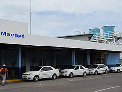
Macapá International Airport
Appearance
Macapá-Alberto Alcolumbre International Airport Aeroporto Internacional de Macapá-Alberto Alcolumbre | |||||||||||
|---|---|---|---|---|---|---|---|---|---|---|---|
 | |||||||||||
| Summary | |||||||||||
| Airport type | Public | ||||||||||
| Operator | Infraero | ||||||||||
| Serves | Macapá | ||||||||||
| Elevation AMSL | 17 m / 56 ft | ||||||||||
| Website | Infraero MCP | ||||||||||
| Map | |||||||||||
 | |||||||||||
| Runways | |||||||||||
| |||||||||||
| Statistics (2013) | |||||||||||
| |||||||||||
Macapá-Alberto Alcolumbre International Airport (IATA: MCP, ICAO: SBMQ) is the airport serving Macapá, Brazil. Since April 22, 2009 the airport is named after Alberto Alcolumbre, a local businessman.[4]
It is operated by Infraero.
History
The airport was opened in 1970.
Because of the Free Trade Zone of Macapá and Santana, regulated by the Federal Law 8.387, of December 30, 1991 at Macapá International Airport anyone, passengers (domestic and international) or visitors, can purchase goods at the Duty Free Shops.[5]
Airlines and destinations
| Airlines | Destinations |
|---|---|
| Azul Brazilian Airlines | Belém |
| Gol Airlines | Belém, Brasília |
| TAM Airlines | Belém, Brasília |
Incident
- 4 July 1970: a Cruzeiro do Sul NAMC YS-11 en route from Belém-Val de Cães to Macapá was hijacked by 1 person and flown to Cayenne, Georgetown, Trinidad and Tobago, Antigua and Jamaica.[6]
Access
The airport is located 3 km (2 mi) from downtown Macapá.
Parking is free of charge.
See also
References
- ^ "Movimento operacional da rede Infraero de janeiro a dezembro de 2013" (PDF) (in Portuguese). Infraero. February 4, 2014. Retrieved July 17, 2014.
- ^ "Airport Official Website" (in Portuguese). Infraero.
- ^ "Lista de aeródromos públicos" (in Portuguese). ANAC.
- ^ "Lei n˚11.931, de 22 de abril de 2009" (in Portuguese). Lei Direto. April 23, 2009. Retrieved April 13, 2011.
- ^ "Lei n˚8.387, de 30 de dezembro de 1991" (in Portuguese). Lei Direto. December 31, 1991. Retrieved April 13, 2011.
- ^ "Incident description 4 July 1970". Aviation Safety Network. Retrieved July 30, 2011.
External links
- Template:WAD
- Airport information for SBMQ at Great Circle Mapper. Source: DAFIF (effective October 2006).
- Current weather for SBMQ at NOAA/NWS
- Accident history for MCP at Aviation Safety Network
- Macapá International Airport Photo Archive at airliners.net

