
Madison County, Alabama
Madison County | |
|---|---|
 Location within the U.S. state of Alabama | |
 Alabama's location within the U.S. | |
| Coordinates: 34°45′57″N 86°33′28″W / 34.765833333333°N 86.557777777778°W | |
| Country | |
| State | |
| Founded | December 13, 1808 |
| Seat | Huntsville |
| Largest city | Huntsville |
| Area | |
| • Total | 813 sq mi (2,110 km2) |
| • Land | 805 sq mi (2,080 km2) |
| • Water | 8 sq mi (20 km2) 0.98% |
| Population (2000) | |
| • Total | 276,700 |
| • Density | 340/sq mi (133/km2) |
| Website | www |
Madison County is a county of the U.S. state of Alabama, and is a major part of the Huntsville Metropolitan Area.
It is also included in the merged Huntsville-Decatur Combined Statistical Area. The county is named in honor of James Madison, fourth President of the United States of America, and the first to visit the state of Alabama. According to the Census' 2008 estimate, the population was 319,510. Its county seat is Huntsville. Madison County covers parts of the former Decatur County.
History
Madison County was established on December 13, 1808 by the governor of the Mississippi territory. Madison County is recognized as the "birthplace" of Alabama, which was founded there on December 14, 1819. For much of the county's history, the economy revolved mainly around agriculture. Madison County was one of the largest cotton-producing counties in the state of Alabama, and textile mills operated around the county.
This all changed when a group of German rocket scientists, led by Wernher von Braun, came to Huntsville in 1950. They developed the Mercury-Redstone Rocket, which eventually became the first vehicle to launch an American into space. Tens of thousands of jobs came to the area as a result of the "space race", and the population of Madison County rose from 72,903 in 1950 to an estimated 2005 population of 298,192.
Geography
According to the U.S. Census Bureau, the county has a total area of 2,105 km² (813 square miles). Nearly 805 square miles (2,085 km²) of it is land, and 8 square miles (21 km²) of it (0.98%) is water.
The topography in the southern and eastern portions of the county is dominated by the dissected remnants of the Cumberland Plateau, such as Keel Mountain, Monte Sano Mountain and Green Mountain. The northern and western portions of the county are flatter.
Major highways
Rail
Rivers
Adjacent counties
- Lincoln County, Tennessee (north)
- Franklin County, Tennessee (northeast)
- Jackson County (east)
- Marshall County (southeast)
- Morgan County (southwest across the Tennessee River)
- Limestone County (west)
Places adjacent to Madison County, Alabama | ||||||||||||||||
|---|---|---|---|---|---|---|---|---|---|---|---|---|---|---|---|---|
| ||||||||||||||||
National protected area
Demographics
| Year | Pop. | ±% |
|---|---|---|
| 1820 | 17,481 | — |
| 1830 | 27,990 | +60.1% |
| 1840 | 25,706 | −8.2% |
| 1850 | 26,427 | +2.8% |
| 1860 | 26,451 | +0.1% |
| 1870 | 31,267 | +18.2% |
| 1880 | 37,625 | +20.3% |
| 1890 | 38,119 | +1.3% |
| 1900 | 43,702 | +14.6% |
| 1910 | 47,041 | +7.6% |
| 1920 | 51,268 | +9.0% |
| 1930 | 64,623 | +26.0% |
| 1940 | 66,317 | +2.6% |
| 1950 | 72,903 | +9.9% |
| 1960 | 117,348 | +61.0% |
| 1970 | 186,540 | +59.0% |
| 1980 | 196,966 | +5.6% |
| 1990 | 238,912 | +21.3% |
| 2000 | 276,700 | +15.8% |
| Sources: "American FactFinder". United States Census Bureau. through 1960 | ||
As of the censusTemplate:GR of 2000, there were 276,700 people, 109,955 households, and 75,319 families residing in the county. The population density was 344 people per square mile (133/km²). There were 120,288 housing units at an average density of 149 per square mile (58/km²). The racial makeup of the county was 72.06% White, 22.78% Black or African American, 0.77% Native American, 1.86% Asian, 0.06% Pacific Islander, 0.59% from other races, and 1.89% from two or more races. Nearly 1.89% of the population were Hispanic or Latino of any race.
There were 109,955 households, out of which 33.00% had children under the age of 18 living with them; 53.40% were married couples living together, 11.80% had a female householder with no husband present, and 31.50% were non-families. Nearly 27.20% of all households were made up of individuals, and 7.40% had someone living alone who was 65 years of age or older. The average household size was 2.45, and the average family size was 3.00.
In the county, the population was spread out with 25.60% under the age of 18, 9.40% from 18 to 24, 31.50% from 25 to 44, 22.70% from 45 to 64, and 10.80% who were 65 years of age or older. The median age was 36 years. For every 100 females, there were 95.30 males. For every 100 females age 18 and over, there were 92.10 males.
The median income for a household in the county was $44,704, and the median income for a family was $54,360. Males had a median income of $40,779 versus $26,534 for females. The per capita income for the county was $23,091. About 8.10% of families and 10.50% of the population were below the poverty line, including 14.10% of those under age 18 and 9.60% of those age 65 or over.
Education
The Madison County School System runs public schools throughout the unincorporated areas of the county and the incorporated and unincorporated communities of Gurley, New Hope, Meridianville, Hazel Green, Toney, Monrovia, New Market, and Owens Cross Roads. The system runs 14 elementary schools, 4 middle schools, 5 high schools and a ninth grade school, and a career/technical center.
High schools in the Madison County School System are:
- Buckhorn High School (New Market, Alabama)
- Hazel Green High School
- Madison County High School (in Gurley)
- New Hope High School
- Sparkman High School (in Harvest)
There are a number of private schools serving Madison County. These include Madison Academy, Westminster Christian Academy, Faith Christian Academy, and several others.
Municipalities and census-designated places
- Gurley
- Harvest
- Hazel Green
- Huntsville (part - part of Huntsville is in Limestone County)
- Madison (part - part of Madison is in Limestone County)
- Meridianville
- Moores Mill
- New Hope
- New Market
- Owens Cross Roads
- Redstone Arsenal
- Triana
- Toney
Places of interest
Madison County is home to Monte Sano State Park, the U.S. Space and Rocket Center and part of the Flint River. It also contains Hampton Cove Golf Course, part of the Robert Trent Jones Golf Trail.
See also
- National Register of Historic Places listings in Huntsville, Alabama
- National Register of Historic Places listings in Madison County, Alabama
- Properties on the Alabama Register of Landmarks and Heritage in Madison County, Alabama
References
External links
- Madison County Commission
- Madison County Schools
- Madison Alabama Chamber of Commerce
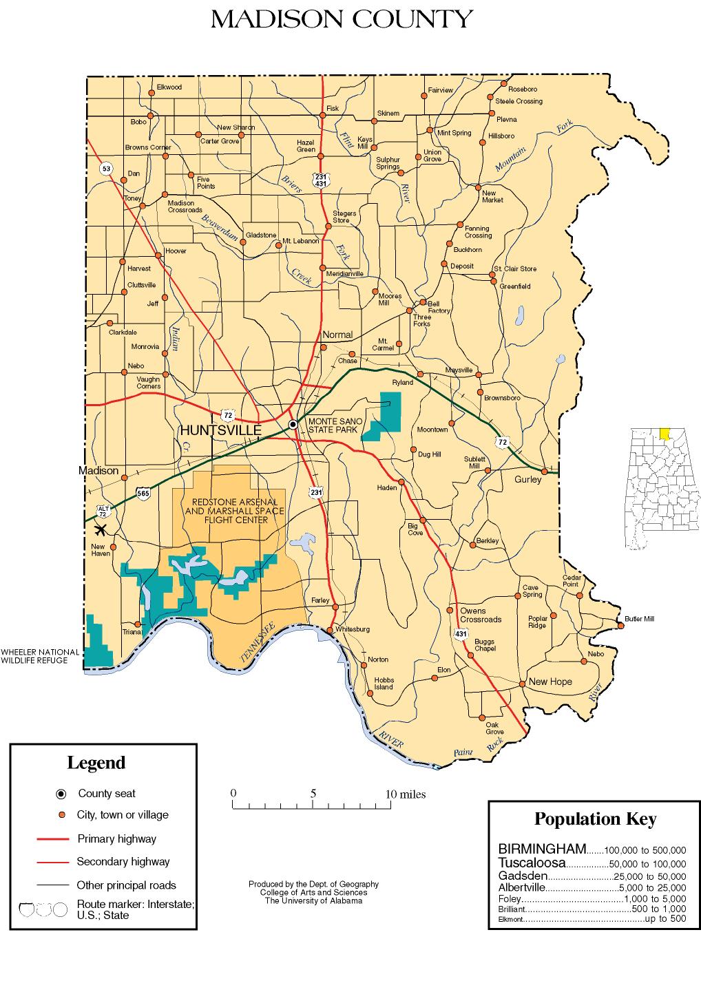
- Madison County map of roads/towns (map © 2007 Univ. of Alabama).
Template:Huntsville-Decatur Metropolitan Area
Municipalities and communities of Madison County, Alabama, United States | ||
|---|---|---|
| Cities |  | |
| Towns | ||
| CDPs | ||
| Unincorporated communities | ||
| Footnotes | ‡This populated place also has portions in an adjacent county or counties | |