
Minute Man National Historical Park
| Minute Man National Historical Park | |
|---|---|
IUCN category V (protected landscape/seascape) | |
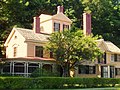
 Hartwell Tavern, Lincoln, Massachusetts | |
 | |
| Location | Middlesex County, Massachusetts, United States |
| Nearest city | Lexington, Massachusetts |
| Coordinates | 42°27′11″N 71°17′55″W / 42.45306°N 71.29861°W |
| Area | 967 acres (391.3 ha) |
| Established | September 21, 1959 |
| Visitors | 1,002,833 (in 2011)[1] |
| Governing body | National Park Service |
| Website | Minute Man National Historical Park |

Not to be confused with Minuteman Missile National Historic Site.
Minute Man National Historical Park commemorates the opening battle in the American Revolutionary War. It also includes the Wayside, home in turn to three noted American authors. The National Historical Park is under the jurisdiction of the National Park Service and protects 970 acres (392.5 ha) in and around the Massachusetts towns of Lexington, Lincoln, and Concord.
Sites
These sites include:
- Concord's North Bridge, where on April 19, 1775, colonial commanders ordered militia men to fire back at British troops for the first time. British colonial militia and minutemen killed three regular army soldiers and wounded eight at the North Bridge Fight. This was the second battle of the day, after the brief fight at dawn on Lexington Common. In his 1837 poem, "Concord Hymn", thinker and author Ralph Waldo Emerson immortalized the North Bridge Fight as "the shot heard round the world". At this site also stands Daniel Chester French's well-known Minute Man Statue of 1875.[2] Across the North Bridge, opposite the Minute Man Statue is the Obelisk Monument. The Obelisk is believed to be the country's first memorial to its war casualties.
- The five-mile (8 km) "Battle Road Trail" between Lexington and Concord, which includes a restored colonial landscape approximating the path of the running skirmishes between British troops and Colonial militia, a monument at the site where Paul Revere was captured during his midnight ride, and the Hartwell Tavern, a restored 18th-century inn and house on the Battle Road, where living history programs are presented from May through October. The Battle Road Trail winds through fields and forests and is accessible from several different parking areas.
- The Wayside, home in turn to authors Amos Bronson Alcott and his daughter Louisa May Alcott, Nathaniel Hawthorne, and Margaret Sidney.
Park visitor centers are located at the hill overlooking the North Bridge and along Battle Road. The main visitor center, on Route 2A/Battle Road, features a 25-minute multi-media show, "Road to Revolution" that gives a good introduction to the Lexington-Concord events.
- Lexington Battle Green, formerly known as Lexington Common, site of the first action on April 19, 1775 is part of the park's story, but the Town of Lexington owns and maintains it. The Green is also where the Captain Parker Statue by Henry Hudson Kitson is located.
Image gallery
-
 Old North Bridge, Concord, Massachusetts July 2005
 -
 The Minute Man statue adjacent to the North Bridge
 -
 Memorial obelisk adjacent to the North Bridge
 -
-
 Captain William Smith House


See also
- National Register of Historic Places listings in Concord, Massachusetts
- National Register of Historic Places listings in Middlesex County, Massachusetts
References
- ^ "National Park Service Visitor Use Statistics". National Park Service. Retrieved October 6, 2012.
- ^ Yeo, Douglas. "Daniel Chester French: The "Concord Minuteman"". Retrieved 2009-10-31.
External links
Wikimedia Commons has media related to Minute Man National Historical Park.
- National Park Service: Minute Man National Historical Park
- National Park Service Digital Image Archive of Minute Man NHS
- [1] Virtual bikeride of Battle Road Trail
National Historical Parks of the United States | ||
|---|---|---|
| ||
| Topics |  | ||||||||||||||||
|---|---|---|---|---|---|---|---|---|---|---|---|---|---|---|---|---|---|
| Lists by county | |||||||||||||||||
| Lists by city |
| ||||||||||||||||
| Other lists | |||||||||||||||||
Categories:
- IUCN Category V
- Minute Man National Historical Park
- American Revolutionary War sites
- Concord, Massachusetts
- Lexington, Massachusetts
- Landmarks in Massachusetts
- Massachusetts in the American Revolution
- National Register of Historic Places in Middlesex County, Massachusetts
- Military in Massachusetts
- Protected areas established in 1959
- National Historical Parks in Massachusetts
- Museums in Middlesex County, Massachusetts
- Military and war museums in Massachusetts
- History museums in Massachusetts
- Parks in Middlesex County, Massachusetts
- American Revolutionary War museums in Massachusetts
- 1959 establishments in Massachusetts
- Museums in Concord, Massachusetts
- American Revolution on the National Register of Historic Places