
Nizamuddin East
Nizamuddin East | |
|---|---|
neighbourhood | |
 Nizamuddin East Location in Delhi, India | |
| Coordinates: 28°35′N 77°15′E / 28.59°N 77.25°E | |
| Country | |
| State | Delhi |
| Metro | New Delhi |
| Government | |
| • Body | Delhi Municipality |
| Languages | |
| • Official | Hindi, Urdu, English, Punjabi |
| Time zone | UTC+5:30 (IST) |
| PIN | 110013 |
| Lok Sabha constituency | Nizamuddin East |
| Vidhan Sabha constituency | Nizamuddin East |
| Planning agency | Delhi Municipality |
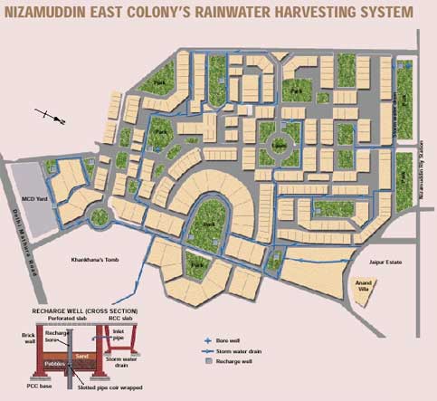
Nizamuddin East is a residential colony in Delhi, India. It is located on Mathura Road and is home to Humayun's Tomb, as well as that of Abdul Rahim Khan-I-Khana. The colony has 286 houses, including Jaipur Estate, and 32 public parks.[citation needed]
Inside the colony is a small center of the Arya Samaj.

Nizamuddin, named after the 13th century Sufi saint, is a centrally located residential area within the ring road. Set in the backdrop of the spectacular Humayun's tomb, to its north and Khan Khana Tomb to its South.
Notable residents
- Hukumat Rai Gandhi, first station master of Nizamuddin Railway Station which caused the founding of the colony and hence the first president of the resident welfare association
- Sheila Dikshit, former Chief Minister of Delhi
- Navin Chawla, election commissioner
- Anjolie Ela Menon, artist
- Vasudeo S. Gaitonde, artist
- Jatin Das, artist
- Nandita Das, actress
- B. C. Sanyal, artist
- Arpita Singh, artist
- Dom Moraes, writer
- Leela Naidu, actress
- M. S. Gill, member of parliament
- Arun Bhatnagar, retired civil servant
- Aman Nath, of the Neemrana Hotels chain
- Sandeep Dikshit, former Member of parliament
- Ajay Jadeja, cricket player
- Ratna Fabri, Museologist
- Dev Benegal, filmmaker
- Shyam Benegal, screenwriter
- Vinod Mehta, journalist
- Mark Tully, BBC journalist
- Ajit Bhattacharjea, Indian Express editor
Transport
- The Hazrat Nizamuddin Railway Station.
- The Delhi Transport Corporation (DTC) buses are also run to this suburb.
See also
- Hazrat Nizamuddin Post Office
- Nizamuddin East is home to one of the New Delhi's YMCAs, as well.
- Sunder Nursery