
Rega
| Rega | |
|---|---|
 Rega Basin | |
| Physical characteristics | |
| Source | |
| • location | near Imienko |
| • elevation | 177.5 m (582 ft) |
| Mouth | |
• location | Baltic Sea |
| Length | 172 km (107 mi) |
| Basin size | 2,724.9 km2 (1,052.1 sq mi) |
| Discharge | |
| • average | 21.80 m3/s (770 cu ft/s) |
| Basin features | |
| Progression | West then North |
| Tributaries | |
| • left | Ukleja, Stara Rega (river), Reska Węgorza |
| • right | Mołstowa, Rekowa |
The Rega is a river in north-western Poland, flowing into the Baltic Sea. It is the country's 24th longest river, with a total length of 168 km and a catchment area of 2,725 km².[1]
Towns on the Rega:
Photogalery
-
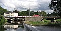
 Świdwin
 -
 Łobez
Łobez -
 Resko
Resko -
 Płoty
Płoty -
 Gryfice
 -
 Trzebiatów
 -
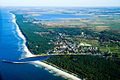 Mrzeżyno - (Baltic Sea)


References
- ^ Marek Lityński: Rega z dopływami. Warszawa: Wydawnictwo PTTK "Kraj", 2004, s. 5–15. ISBN 83-7005-472-2
See also
Wikimedia Commons has media related to Rega.
Wikimedia Commons has media related to Rega.
54°08′46″N 15°17′07″E / 54.1462°N 15.2854°E
| Vistula | |
|---|---|
| Odra | |
| Vistula Lagoon | |
| Baltic Sea | |