Shusha District
Shusha | |
|---|---|
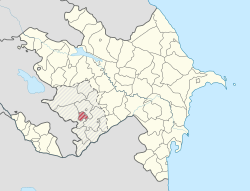
 Map of Azerbaijan showing Shusha District | |
| Country | Azerbaijan - Nagorno Karabakh Republic |
| Capital | Shusha |
| Area | |
| • Total | 290 km2 (110 sq mi) |
| Population (2009)[1] | |
| • Total | 28,300 |
| Telephone code | (+994) 26[2] |
Shusha (Azeri: Şuşa) is a rayon of Azerbaijan. It surrounds the city of Shusha, in Nagorno-Karabakh, and is completely under control of the unrecognised Nagorno-Karabakh Republic.
References
- ^ a b "Şuşa rayonu".
- ^ "Şəhərlərarası telefon kodları". Aztelekom MMC. gharabaghtelekom İB. Retrieved 19 August 2015. Template:Az

