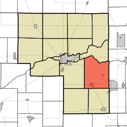
Tipton Township, Cass County, Indiana
Appearance
Tipton Township | |
|---|---|
 Farmland in Tipton Township | |
 Location of Tipton Township in Cass County | |
| Coordinates: 40°41′54″N 86°13′06″W / 40.69833°N 86.21833°W | |
| Country | United States |
| State | Indiana |
| County | Cass |
| Government | |
| • Type | Indiana township |
| Area | |
• Total | 40.77 sq mi (105.58 km2) |
| • Land | 40.62 sq mi (105.22 km2) |
| • Water | 0.14 sq mi (0.36 km2) |
| Elevation | 755 ft (230 m) |
| Population | |
• Total | 2,304 |
| • Density | 57/sq mi (22/km2) |
| FIPS code | 18-75968[3] |
| GNIS feature ID | 453899 |
Tipton Township is one of fourteen townships in Cass County, Indiana, United States. As of the 2020 census, its population was 2,304 (down from 2,490 at 2010[4]) and contained 1,011 housing units.
History
[edit]Tipton Township was organized in 1840.[5] It was named for Indiana Senator John Tipton.[6]
Pipe Creek Falls Resort was listed on the National Register of Historic Places in 1995.[7]
Geography
[edit]Tipton Township covers an area of 40.77 square miles (105.6 km2); 0.14 square miles (0.36 km2) (0.34 percent) of this is water.
Cities and towns
[edit]Adjacent townships
[edit]- Miami (north)
- Peru Township, Miami County (northeast)
- Pipe Creek Township, Miami County (east)
- Deer Creek Township, Miami County (southeast)
- Jackson (south)
- Deer Creek (southwest)
- Washington (west)
Major highways
[edit]Cemeteries
[edit]The township contains five cemeteries: Bowyer, Little Deer Creek, Shaff, Venard and Walton.
References
[edit]- ^ "US Board on Geographic Names". United States Geological Survey. October 25, 2007. Retrieved January 31, 2008.
- ^ "Census Bureau profile: Tipton Township, Cass County, Indiana". United States Census Bureau. May 2023. Retrieved April 4, 2024.
- ^ "U.S. Census website". United States Census Bureau. Retrieved January 31, 2008.
- ^ "Geographic Identifiers: 2010 Demographic Profile Data (G001): Tipton township, Cass County, Indiana". U.S. Census Bureau, American Factfinder. Archived from the original on February 12, 2020. Retrieved January 15, 2013.
- ^ Powell, Jehu Z. (1913). History of Cass County Indiana: From Its Earliest Settlement to the Present Time. Lewis Publishing Company. pp. 678.
- ^ Helm, Thomas B. (1878). History of Cass County, Indiana. Kingman Bros. pp. 42.
- ^ "National Register Information System". National Register of Historic Places. National Park Service. July 9, 2010.
External links
[edit]Wikimedia Commons has media related to Tipton Township, Cass County, Indiana.

