User:West Virginian/Hampshire County, West Virginia
Appearance
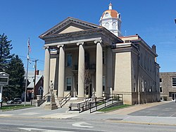
Hampshire County | |
|---|---|
 | |
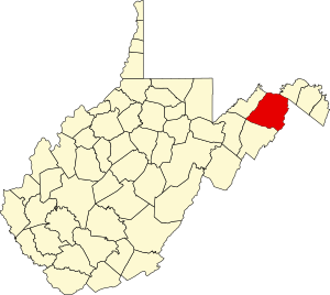
 Location within the U.S. state of West Virginia | |
 West Virginia's location within the U.S. | |
| Country | |
| State | |
| Founded | December 13, 1753 |
| Named for | Hampshire, England |
| Seat | Romney |
| Largest city | Romney |
| Area | |
• Total | 645 sq mi (1,670 km2) |
| • Land | 640 sq mi (1,700 km2) |
| • Water | 4.2 sq mi (11 km2) 0.7% |
| Population (2010) | |
• Total | 23,964 |
| • Density | 37.4/sq mi (14.4/km2) |
| Time zone | UTC−5 (Eastern) |
| • Summer (DST) | UTC−4 (EDT) |
| Congressional district | 2nd |
| Website | www |
| West Virginia county number 027 | |
History
[edit]Historic places
[edit]Geography
[edit]Climate and weather
[edit]Transportation
[edit]Economy
[edit]Education and health care
[edit]Notable people
[edit]Culture
[edit]Media
[edit]Recreation
[edit]Government
[edit]Demographics
[edit]References
[edit]Bibliography
[edit]- Brannon, Selden W. (1976). Historic Hampshire: A Symposium of Hampshire County and Its People, Past and Present. Parsons, West Virginia: McClain Printing Company. ISBN 978-0-87012-236-1. OCLC 3121468.
- Federal Writers' Project (1937). Historic Romney 1762–1937. Romney, West Virginia: Federal Writers' Project, The Town Council of Romney, West Virginia. OCLC 2006735.
- Hampshire County Extension Homemakers (1991). Hampshire County, West Virginia: A Pictorial History. Marceline, Missouri: Hampshire County Extension Homemakers, Walsworth Publishing Company. ISBN 978-1-60354-047-6. OCLC 51940415.
- Maxwell, Hu; Swisher, Howard Llewellyn (1897). History of Hampshire County, West Virginia From Its Earliest Settlement to the Present. Morgantown, West Virginia: A. Brown Boughner, Printer. OCLC 680931891. OL 23304577M.
- Munske, Roberta R.; Kerns, Wilmer L. (2004). Hampshire County, West Virginia, 1754-2004. The Hampshire County 250th Anniversary Committee. ISBN 978-0-9715738-2-6. OCLC 55983178.
{{cite book}}: Unknown parameter|coauthors=ignored (|author=suggested) (help) - West Virginia Legislature (2012). Darrell E. Holmes, Clerk of the West Virginia Senate (ed.). West Virginia Blue Book, 2012 (PDF). Charleston, West Virginia: Chapman Printing.
{{cite book}}: Unknown parameter|coauthors=ignored (|author=suggested) (help)
See also
[edit]External links
[edit]39°19′N 78°37′W / 39.31°N 78.61°W
Category:1754 establishments in the Thirteen Colonies
Category:1754 establishments in Virginia
Category:Counties of Appalachia
Category:Northwestern Turnpike
Category:West Virginia counties
Category:West Virginia counties on the Potomac River
Category:Winchester, VA-WV metropolitan area


