Waterland
Waterland | |
|---|---|
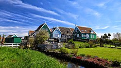
 Marken, municipality of Waterland | |
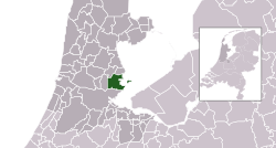
 Location in North Holland | |
| Coordinates: 52°27′N 5°2′E / 52.450°N 5.033°E | |
| Country | Netherlands |
| Province | |
| Established | 1 January 1991 |
| Government | |
| • Body | Municipal council |
| • Mayor | Luzette Wagenaar-Kroon (CDA) |
| Area | |
| • Total | 115.66 km2 (44.66 sq mi) |
| • Land | 52.11 km2 (20.12 sq mi) |
| • Water | 63.55 km2 (24.54 sq mi) |
| Elevation | −1 m (−3 ft) |
| Population (January 2021)[4] | |
| • Total | 17,312 |
| • Density | 332/km2 (860/sq mi) |
| Demonym | Waterlander |
| Time zone | UTC+1 (CET) |
| • Summer (DST) | UTC+2 (CEST) |
| Postcode | 1140–1156, 1452–1454 |
| Area code | 0299 |
| Website | www |
Waterland (ⓘ) is a municipality in the Netherlands, located in the province of North Holland. It is situated north of Amsterdam, on the western shore of the Markermeer. It is well-known for comprising the touristy towns of Broek in Waterland and Marken.
Population centres
The municipality of Waterland consists of the following cities, towns, villages and districts: Broek in Waterland, Ilpendam, Katwoude, Marken, Monnickendam, Overleek, Uitdam, Watergang, Zuiderwoude.
Topography
Topographic map of the municipality of Waterland, 2013.
Local government
The municipal council of Waterland consists of 17 seats, which are divided as follows:
|
|
Gallery
Notable people


- Pieter Floriszoon (1602 or 1606 in Monnickendam – 1658) a Dutch Vice Admiral in the Battle of the Sound
- Alexander Johan Berman (1828 in Zierikzee – 1886) the Dutch Reformed minister of Watergang
- Pieter Groenhart (1894 in Ilpendam – 1965) a Dutch lichenologist, researched tropical Asian lichens
- Wim Polak (1924–1999) a Dutch politician, lived in Ilpendam, Mayor of Amsterdam 1977/1983
- Peter Spier (1927–2017) a Dutch-American illustrator and writer of children's books, grew up in Broek in Waterland
- Michaël Zeeman (1958 in Marken – 2009) a Dutch journalist, author, editor, columnist and literary critic
- Sita (born 1980 in Ilpendam) aka Sita Maria Vermeulen, a Dutch pop singer
- Sport
- Jurjaan Koolen (born 1938) a Dutch volleyball player, competed in the 1964 Summer Olympics
- Marko Klok (born 1968 in Monnickendam) a volleyball player, silver medallist in the 1992 Summer Olympics
- Annette Gerritsen (born 1985 in Ilpendam) a Dutch former speed skater, silver medallist at the 2010 Winter Olympics
References
- ^ "College van burgemeester & wethouders" [Board of mayor and aldermen] (in Dutch). Gemeente Waterland. Retrieved 23 March 2014.
- ^ "Kerncijfers wijken en buurten 2020" [Key figures for neighbourhoods 2020]. StatLine (in Dutch). CBS. 24 July 2020. Retrieved 19 September 2020.
- ^ "Postcodetool for 1141GV". Actueel Hoogtebestand Nederland (in Dutch). Het Waterschapshuis. Retrieved 23 March 2014.
- ^ "Bevolkingsontwikkeling; regio per maand" [Population growth; regions per month]. CBS Statline (in Dutch). CBS. 1 January 2021. Retrieved 2 January 2022.
External links
 Media related to Waterland at Wikimedia Commons
- Official website


