
West Yorkshire
West Yorkshire | |
|---|---|
 | |
| Coordinates: 53°45′N 1°40′W / 53.750°N 1.667°W | |
| Sovereign state | United Kingdom |
| Constituent country | England |
| Region | Yorkshire and the Humber |
| Established | 1 April 1974 |
| Preceded by | West Riding of Yorkshire |
| Origin | Local Government Act 1972 |
| Time zone | UTC+0 (GMT) |
| • Summer (DST) | UTC+1 (BST) |
| UK Parliament | List of MPs |
| Police | West Yorkshire Police |
| Ceremonial county | |
| Lord Lieutenant | Ingrid Roscoe |
| High Sheriff | Ed Anderson |
| Area | 2,029 km2 (783 sq mi) |
| • Rank | 29th of 48 |
| Population (2022)[1] | 2,378,148 |
| • Rank | 4th of 48 |
| Density | 1,172/km2 (3,040/sq mi) |
| Ethnicity | 81.8% White 11.6% S. Asian 2.1% Mixed 2.1% Black 2.4% Other |
| Metropolitan county | |
| Government | West Yorkshire Combined Authority |
| Admin HQ | Leeds |
| GSS code | E11000006 |
| ITL | UKE4 |
| Website | www |
| Districts | |
 Districts of West Yorkshire Metropolitan districts | |
| Districts | |
West Yorkshire is a metropolitan county in England. It is located in the region of Yorkshire and the Humber with a population of 2.2 million. West Yorkshire came into existence as a metropolitan county in 1974 after the passage of the Local Government Act 1972.[2]
West Yorkshire, which is landlocked, consists of five metropolitan boroughs (City of Bradford, Calderdale, Kirklees, City of Leeds and City of Wakefield) and shares borders with the counties of Derbyshire (to the south), Greater Manchester (to the south-west), Lancashire (to the north-west), North Yorkshire (to the north and east) and South Yorkshire (to the south-east).
West Yorkshire County Council was abolished in 1986, and so its districts (the metropolitan boroughs) are now effectively unitary authorities. However, the metropolitan county, which covers an area of 2,029 square kilometres (783 sq mi), continues to exist in law, and as a geographic frame of reference.[3][4][5] Since 1 April 2014 West Yorkshire has been a combined authority area, with the local authorities pooling together some functions over transport and regeneration as the West Yorkshire Combined Authority.
West Yorkshire includes the West Yorkshire Urban Area, which is the most built-up and biggest urban area within the historic county boundaries of Yorkshire.
History


West Yorkshire was formed as a metropolitan county in 1974, by the Local Government Act 1972, and corresponds roughly to the core of the historic West Riding of Yorkshire and the county boroughs of Bradford, Dewsbury, Halifax, Huddersfield, Leeds, and Wakefield.
West Yorkshire Metropolitan County Council inherited the use of West Riding County Hall at Wakefield, opened in 1898, from the West Riding County Council in 1974. Since 1987 it has been the headquarters of Wakefield City Council.[6]
The county initially had a two-tier structure of local government with a strategic-level county council and five districts providing most services.[7] In 1986, throughout England the metropolitan county councils were abolished. The functions of the county council were devolved to the boroughs; joint-boards covering fire, police and public transport; and to other special joint arrangements.[8] Organisations such as West Yorkshire Police Authority and West Yorkshire Passenger Transport Executive continue to operate on this basis.
Although the county council was abolished, West Yorkshire continues to form a metropolitan and ceremonial county with a Lord Lieutenant of West Yorkshire and a High Sheriff.
Wakefield's Parish Church was raised to cathedral status in 1888 and after the elevation of Wakefield to diocese, Wakefield Council immediately sought city status and this was granted in July 1888.[9] However the industrial revolution, which changed West and South Yorkshire significantly, led to the growth of Leeds and Bradford, which became the area's two largest cities (Leeds being the largest in Yorkshire). Leeds was granted city status in 1893 and Bradford in 1897. The name of Leeds Town Hall reflects the fact that at its opening in 1858 Leeds was not yet a city, while Bradford renamed its Town Hall as City Hall in 1965.[10]
| post-1974 | pre-1974 | ||||
|---|---|---|---|---|---|
| Metropolitan county | Metropolitan borough | County boroughs | Non-county boroughs | Urban districts | Rural districts |
 |
Bradford | Bradford | Keighley | Baildon • Bingley • Denholme • Ilkley • Queensbury and Shelf[11] •Silsden • Shipley | Skipton |
| Calderdale | Halifax | Brighouse • Todmorden | Elland • Hebden Royd • Queensbury and Shelf[11] • Ripponden • Sowerby Bridge | ||
| Kirklees | Huddersfield • Dewsbury | Batley • Spenborough | Colne Valley • Denby Dale • Heckmondwike • Holmfirth • Kirkburton • Meltham • Mirfield | ||
| Leeds | Leeds | Morley • Pudsey | Aireborough • Garforth • Horsforth • Otley • Rothwell | Tadcaster • Wharfedale • Wetherby | |
| Wakefield | Wakefield | Castleford • Ossett • Pontefract | Featherstone • Hemsworth • Horbury • Knottingley • Normanton • Stanley | Hemsworth • Osgoldcross • Wakefield | |
Geography

The county borders, going anticlockwise from the west: Lancashire, Greater Manchester, Derbyshire, South Yorkshire and North Yorkshire. It lies almost entirely on rocks of carboniferous age which form the southern Pennine fringes in the west[12] and the Yorkshire coalfield further eastwards.[13] In the extreme east of the metropolitan county there are younger deposits of magnesian limestone.[14] The Bradford and Calderdale areas are dominated by the scenery of the eastern slopes of the Pennines, dropping from upland in the west down to the east, and dissected by numerous steep-sided valleys. There is a close conjunction of large scale industry, urban areas and transport routes with open countryside. The dense network of roads, canals and railways and urban development, confined by valleys creates dramatic interplay of views between settlements and the surrounding hillsides.[citation needed]
The carboniferous rocks of the Yorkshire coalfield further east have produced a rolling landscape with hills, escarpments and broad valleys. In this landscape there is widespread evidence of both current and former industrial activity. There are numerous derelict or converted mine buildings and recently landscaped former spoil heaps.[citation needed] The scenery is a mixture of built up areas, industrial land with some dereliction, and farmed open country. Ribbon developments along transport routes including canal, road and rail are prominent features of the area although some remnants of the pre industrial landscape and semi-natural vegetation still survive. However, many areas are affected by urban fringe pressures creating fragmented and downgraded landscapes and ever present are urban influences from major cities, smaller industrial towns and former mining villages.[citation needed]
In the magnesian limestone belt to the east of the Leeds and Wakefield areas is an elevated ridge with smoothly rolling scenery, dissected by dry valleys. Here, there is a large number of country houses and estates with parkland, estate woodlands, plantations and game coverts.[citation needed]
The rivers Aire and Calder drain the area, flowing from west to east.
The table below outlines many of the county's settlements, and is formatted according to their metropolitan borough.
Climate
West Yorkshire has an Oceanic climate, similar to almost all the United Kingdom. West Yorkshire tends to be cooler than counties further south, due to the inland location and high elevation (especially in the west of the county), and snow is common, as are sub-zero temperatures. In December 2010, many rivers in West Yorkshire froze over, such as the River Wharfe and River Aire.
Temperatures vary throughout the year, often sometimes reaching 30 °C (86 °F), and in winter temperatures have been reported to fall as low as −16 °C (3 °F) (as in December 2010), but in general they remain between −1 °C (30 °F) and 20 °C (68 °F) all year.
| Climate data for West Yorkshire | |||||||||||||
|---|---|---|---|---|---|---|---|---|---|---|---|---|---|
| Month | Jan | Feb | Mar | Apr | May | Jun | Jul | Aug | Sep | Oct | Nov | Dec | Year |
| Mean daily maximum °C (°F) | 5 (41) |
5 (41) |
8 (46) |
11 (52) |
15 (59) |
18 (64) |
19 (66) |
19 (66) |
17 (63) |
13 (55) |
8 (46) |
6 (43) |
12 (54) |
| Mean daily minimum °C (°F) | 0 (32) |
0 (32) |
1 (34) |
3 (37) |
5 (41) |
8 (46) |
10 (50) |
10 (50) |
8 (46) |
6 (43) |
2 (36) |
1 (34) |
5 (40) |
| Average rainfall mm (inches) | 61 (2.4) |
45 (1.8) |
52 (2.0) |
48 (1.9) |
54 (2.1) |
54 (2.1) |
51 (2.0) |
65 (2.6) |
57 (2.2) |
55 (2.2) |
57 (2.2) |
61 (2.4) |
660 (25.9) |
| Source 1: www.worldtravels.com[15] | |||||||||||||
| Source 2: www.wunderground.com[16] | |||||||||||||
Governance

In Parliament, 15 out of 23 of West Yorkshire's M.P.s are Labour, 6 are Conservative and 2 are Liberal Democrats. At local level, the councils are generally divided, apart from the Wakefield district, which has long been one of the safest Labour councils in the country.
Certain services are provided across the county by West Yorkshire Joint Services, and the West Yorkshire Police and West Yorkshire Fire and Rescue Service are also county-wide.
Demography
| District | Area km2 | Population | Population density |
|---|---|---|---|
| City of Bradford | 366.42 | 523,100 | 1,346 |
| Calderdale | 363.92 | 200,100 | 545 |
| Kirklees | 408.61 | 401,000 | 975 |
| City of Leeds | 551.72 | 761,100 | 1,360 |
| City of Wakefield | 338.61 | 321,600 | 949 |

-
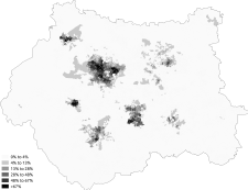
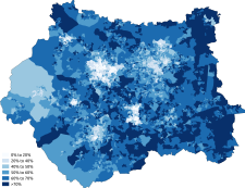
 White
White -
 White-British
 -
 White-Irish
 -
 White-Other
 -
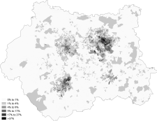
 Asian
Asian -
 Asian-Indian
 -
 Asian-Pakistani
 -
 Asian-Bangladeshi
 -
 Asian-Chinese
 -
 Black
Black -
 Black-African
 -
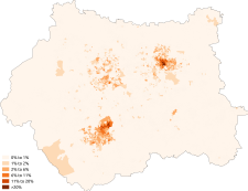 Black-Caribbean
 -
 Other-Arab


-
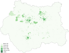
 Christianity
 -
 Islam
Islam -
 Judaism
 -
 Hinduism
 -
 Sikhism
 -
 Buddhism
 -
 Other religion
 -
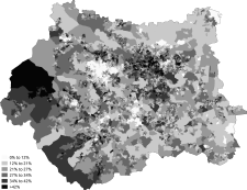 No religion


Economy

This is a chart of regional gross value added for West Yorkshire at current basic prices with figures in millions of British Pounds Sterling.[17]
| Year | Regional Gross Value Added[18] | Agriculture[19] | Industry[20] | Services[21] |
|---|---|---|---|---|
| 1995 | 21,302 | 132 | 7,740 | 13,429 |
| 2000 | 27,679 | 80 | 8,284 | 19,314 |
| 2003 | 31,995 | 91 | 8,705 | 23,199 |
Industries
West Yorkshire grew up around several industries. Bradford, Halifax and Huddersfield were grown through the development of woollen mills, Leeds' traditional industry was the manufacturing of cloth, while heavier engineering industries facilitated growth in South Leeds. Wakefield, Castleford, Pontefract and South and East Leeds were traditional coal mining areas. The woollen and cloth industries declined throughout the twentieth century, while mining in West Yorkshire declined through the late 1980s and 1990s, leaving only Kellingley Colliery and a few open cast mines today.
Leeds has since attracted investment from financial institutions, to become a recognised financial centre, with many banks, building societies and insurance companies having offices in the city. Wakefield has also attracted many service based industries, inparticularly call centres. Two of the big four supermarkets are from West Yorkshire. Morrisons is based in Bradford, while Asda is based in Leeds. Netto have their British headquarters in South Elmsall.
Transport

West Yorkshire lies in arguably the most strategic part of Yorkshire: the M62, M1 and the A1(M) pass through the county, as well as the internal urban motorways in Leeds and Bradford. West Yorkshire has two mainline railway stations, Leeds and Wakefield Westgate. Leeds railway station is the only Network Rail principal station in Yorkshire and North East England, and one of only three in the North of England along with Manchester Piccadilly and Liverpool Lime Street. Other important railway stations in West Yorkshire include Bradford Interchange, Bradford Forster Square, Huddersfield, Halifax, Dewsbury, Keighley and Shipley. West Yorkshire also has Yorkshire's largest airport, Leeds Bradford International Airport.
Unlike South Yorkshire, West Yorkshire has no light transit system; the Leeds Supertram was proposed, but was later cancelled after the withdrawal of government funding; the Leeds Trolleybus is the current proposed scheme. Public transport is run under the authority of the West Yorkshire Passenger Transport Executive (Metro).
Sport
The three major football clubs in West Yorkshire are Bradford City, Huddersfield Town and Leeds United. Rugby league is also big in West Yorkshire, where the major teams are Bradford Bulls, Huddersfield Giants, Leeds Rhinos. Matches between them are called a West Yorkshire derby.
Other rugby league clubs in West Yorkshire are Castleford Tigers, Wakefield Trinity Wildcats, Featherstone Rovers and Halifax. The main rugby union club in the county is Yorkshire Carnegie.
The Headingley Stadium is home of the Yorkshire County Cricket Club, Leeds Rhinos and Yorkshire Carnegie, whereas the John Smith's Stadium is home of Huddersfield Town and Huddersfield Giants. Valley Parade is home of Bradford City, whereas the Odsal Stadium is home of the Bradford Bulls.
Places of interest
Historic environment
| Key | |
| Abbey/Priory/Cathedral | |
| Accessible open space | |
| Amusement/Theme Park | |
| Castle | |
| Country Park | |
| English Heritage | |
| Forestry Commission | |
| Heritage railway | |
| Historic House | |
| Places of Worship | |
| Museum (free/not free) | |
| National Trust | |
| Theatre | |
| Zoo | |
- Bretton Hall
- Cartwright Hall
- Cliffe Hall, also known as Cliffe Castle, Keighley
- East Riddlesden Hall


- Esholt Hall, Esholt
- Firsby Hall
- Halifax Piece Hall
- Harewood House
- Kershaw House
- Keighley and Worth Valley Railway

- Kirklees Hall/Priory
- Kirkstall Abbey

- Roman Lagentium (Castleford)
- Ledston Hall, Ledston
- Linthwaite Hall, Linthwaite
- Linton Hall
- Lister Park, Bradford
- Lotherton Hall
- Middleton Railway, the world's oldest steam railway
- Nostell Priory
- Oakwell Hall
- Oulton Hall, Oulton
- Pontefract Castle

- Pontefract Priory, Pontefract
- Queen's Park, Castleford
- Roundhay Park Leeds
- Saltaire, a UNESCO World Heritage Site
- Sandal Castle
- Scarcroft Watermill, Scarcroft
- Shelley Hall, Shelley
- Shibden Hall
- Shipley Glen Tramway
- Tong Hall, Tong
- Wetherby Castle, Wetherby


Museums

- Abbey House Museum, Leeds
- Armley Mills Industrial Museum, Leeds
- Bankfield Museum, Halifax
- Bradford Industrial Museum, Eccleshill/Fagley, Bradford
- Brontë Parsonage Museum, Haworth
- Colne Valley Museum, Golcar, Huddersfield
- Eureka, Halifax
- Leeds City Museum, Leeds
- National Coal Mining Museum for England Overton, Wakefield
- National Media Museum, Bradford
- Pennine Farm Museum, Ripponden, Halifax
- Pontefract Museum
- Royal Armouries Museum, Leeds
- Thackray Museum, Leeds
- The Hepworth Wakefield
- Thwaite Mills, Leeds
- Tolson Museum, Dalton, Huddersfield
- Wakefield Museum, Wakefield
- West Yorkshire Folk Museum, Shibden Hall, Halifax
- Yorkshire Sculpture Park, West Bretton, Wakefield
Natural environment

- Emley Moor, site of the tallest self-supporting structure in the UK (a TV mast)
- Harewood Estate – Leeds Country Way public footpath runs through the estate, beautiful landscaped gardens and home to Red Kites amongst many other birds
- Ilkley Moor, part of Rombalds Moor
- New Swillington Ings Nature Reserve
- Otley Chevin – extensive wooded parkland on high ground with extensive views North over Wharfedale and South as far as the Peak District
- RSPB Fairburn Ings – wetland centre for birds
- Seckar Woods LNR, a Local Nature Reserve
- Walton Hall, West Yorkshire, home of naturalist Charles Waterton and the world's first nature reserve
Waterways

- Scammonden Reservoir, Deanhead Reservoir – both in the moors near Ripponden
- River Aire, River Calder, River Hebble, River Spen, River Worth
- Aire and Calder Navigation
- Calder and Hebble Navigation
- Huddersfield Broad Canal
- Huddersfield Narrow Canal, Standedge Tunnel
- Leeds and Liverpool Canal
- Rochdale Canal
See also
- List of Lord Lieutenants of West Yorkshire
- List of High Sheriffs of West Yorkshire
- The Kingdom of Elmet
- West Yorkshire Urban Area
- West Yorkshire Metropolitan Ambulance Service
- West Yorkshire Regiment (The Prince of Wales's Own)
- List of ceremonial counties in England by gross value added
References
Notes
- ^ "Mid-2022 population estimates by Lieutenancy areas (as at 1997) for England and Wales". Office for National Statistics. 24 June 2024. Retrieved 26 June 2024.
- ^ Arnold-Baker, C., Local Government Act 1972, (1973)
- ^ Office for National Statistics – Gazetteer of the old and new geographies of the United Kingdom, p. 48. Retrieved 14 December 2006.
- ^ Metropolitan Counties and Districts, Beginners' Guide to UK Geography, Office for National Statistics, 17 September 2004. Retrieved 11 January 2007.
- ^ Yorkshire and Humber Counties, The Boundary Commission for England. Retrieved 14 February 2007.
- ^ Wakefield City Council (20 November 2004). "County Hall".
- ^ Redcliffe-Maud and Wood, B., English Local Government Reformed, (1974)
- ^ Kingdom, J., Local Government and Politics in Britain, (1991)
- ^ Beckett 2005, pp. 39, 40
- ^ "History of City Hall". City of Bradford Metropolitan District Council. Retrieved 17 January 2009.
- ^ a b The urban district of Queensbury and Shelf was split between Bradford and Calderdale in 1974: Queensbury civil parish was amalgamated into Bradford; Shelf civil parish was amalgamated into Calderdale.
- ^ "Yorkshire Southern Pennine Fringe". www.countryside.gov.uk. Retrieved 6 October 2008.
- ^ "Nottinghamshire, Derbyshire and Yorkshire Coalfield". www.countryside.gov.uk. Retrieved 6 October 2008.
- ^ "Southern Magnesian Limestone". www.countryside.gov.uk. Retrieved 6 October 2008.
- ^ "Leeds average weather data". www.worldtravels.com. Retrieved 21 January 2016.
- ^ "Leeds average weather data". www.wunderground.com. Retrieved 21 January 2016.
- ^ "Regional Gross Value Added" (PDF). Office for National Statistics. 21 December 2005. pp. 240–253. Retrieved 6 October 2008.
- ^ Components may not sum to totals due to rounding
- ^ includes hunting and forestry
- ^ includes energy and construction
- ^ includes financial intermediation services indirectly measured
Bibliography
- Beckett, J. V. (2005), City status in the British Isles,1830–2002, Ashgate Publishing, ISBN 0-7546-5067-7
External links
- West Yorkshire Joint Services
- Images of West Yorkshire at the English Heritage Archive
- West Yorkshire at Curlie
| Metropolitan districts | |
|---|---|
| Major settlements (cities in italics) |
|
| Topics | |
| Ceremonial counties | |
|---|---|
| Historic divisions | |
| Geography | |
| History | |
| Culture and heritage | |
