
Zangilan
39°03′56″N 46°41′49″E / 39.06556°N 46.69694°E
Zəngilan | |
|---|---|
 A street in Zəngilan | |
 Zəngilan | |
| Coordinates: 39°03′56″N 46°41′49″E / 39.06556°N 46.69694°E | |
| Country | |
| Rayon | Zangilan |
| Population (2015) | |
| • Total | 500[1] |
| Time zone | UTC+4 (UTC) |
Zəngilan () is a town and centre of the Zangilan Rayon of Azerbaijan.
History
_J-38-034.jpg)
Soviet rule
Being part of Azerbaijan SSR, the village was known as Pirchivan until 1957. According to data of 1933, population of the village was 574, of which 98.7% were Azerbaijanis.[2] In 31 August, 1957, the village was renamed to Zangilan.[3] It was given the status of a town in 1967.
According to 1979 Soviet census, 5,012 people lived in the town, of which 96.1% were Azerbaijanis and 3.6% Russians or Ukrainians.[4] Population rose to 6,968 in 1989.[5]
Armenian occupation
The town came under the control of ethnic Armenian forces during the Nagorno-Karabakh War on 29 August 1993 and was administered as part of Kashatagh Region by the de facto independent Republic of Artsakh. All the Azerbaijani inhabitants of the city were forcefully driven out. During the period of Armenian control, the town was renamed to Kovsakan (Կովսական). In 2005 the population of the town was less than 400. Following the outbreak of the Syrian Civil War, a growing number of Armenian refugees from Syria had chosen to settle in this town, many of them farmers.[6][7][8]
Recapture by Azerbaijan
Within the context of the 2020 Nagorno-Karabakh conflict, on 20 October 2020, Azerbaijani President Ilham Aliyev announced that Zangilan had been recaptured by the Azerbaijani army.[9] Azerbaijani Ministry of Defence released video from Zangilan shortly after the announcement and the location of the video was confirmed by third-party sources.[10][11][12]
Gallery
-
 Okhchuchay River in Zəngilan
 -
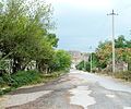 A street in Zəngilan
 -
 Khudapherin Reservoir
 -
 A khachkar in Zəngilan
 -
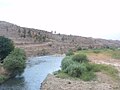 Okhchuchay River in Zəngilan
 -
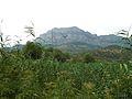 Zəngilan's nature

,_2014.05.09_-_panoramio.jpg)


References
- ^ http://stat-nkr.am/files/publications/2015/LXH_tverov_2015.pdf
- ^ Административное деление АССР [Administrative divisions of the ASSR] (in Russian). p. 101.
- ^ Azerbaijani Soviet Encyclopedia. Vol. 4. 1980. p. 317.
- ^ "ЗАНГЕЛАНСКИЙ РАЙОН (1979 г.)". ethno-kavkaz.narod.ru (in Russian).
- ^ "1989 All-Union Population Census". demoscope.ru (in Russian).
- ^ "Armenia: Syrian Refugees Resettling in Occupied Azerbaijani Territory". EurasiaNet. 28 January 2013.
- ^ "Syrian-Armenians in NKR benefit from AGBU agricultural program".
- ^ "Armenia: refugees in the military". Deutsche Welle.
- ^ "President Ilham Aliyev: Zangilan city and 6 villages of the district, 18 villages of Fuzuli, Jabrayil, and Khojavand districts liberated". mod.gov.az. 20 October 2020.
- ^ @TvIctimai. "Zəngilan şəhərinə üçrəngli bayrağımız sancıldı!" (Tweet) – via Twitter. {{Cite tweet}}: Invalid |number= (help)
- ^ @Krummapper (27 September 2020). "#Azerbaijan forces have been captured Zangilan. Coordinates: 39° 5.374'N 46° 39.641'E" (Tweet) – via Twitter. {{Cite tweet}}: |date= / |number= mismatch (help)
- ^ @GeromanAT (27 September 2020). "Day 24 - Southern Sector" (Tweet) – via Twitter. {{Cite tweet}}: |date= / |number= mismatch (help)
- Zangilan at GEOnet Names Server
- World Gazetteer: Azerbaijan – World-Gazetteer.com

This Zangilan Rayon location article is a stub. You can help Wikipedia by expanding it. |