
Augusta, Maine
Augusta, Maine | |
|---|---|
 Augusta, Maine, taken from the bridge | |
 Flag  Seal | |
 Location in Kennebec County, Maine | |
| Country | United States |
| State | Maine |
| County | Kennebec |
| Established | 1754 |
| Government | |
| • Mayor | Roger Katz |
| Area | |
| • Total | 58.3 sq mi (150.9 km2) |
| • Land | 55.4 sq mi (143.4 km2) |
| • Water | 2.9 sq mi (7.5 km2) 4.98% |
| Elevation | 68 ft (20 m) |
| Population (2000) | |
| • Total | 18,560 |
| • Density | 335.1/sq mi (129.4/km2) |
| Time zone | UTC-5 (Eastern) |
| • Summer (DST) | UTC-4 (Eastern) |
| Area code | 207 |
| FIPS code | 23-02100 |
| GNIS feature ID | 0581636 |
| Website | www.augustamaine.gov |
Augusta is the capital of the U.S. state of Maine, county seat of Kennebec County, and center of population for Maine [1]. The city's population was 18,560 at the 2000 census. Located on the Kennebec River at the head of tide, it is home to the University of Maine at Augusta.
History
The area was first explored by members of the ill-fated Popham Colony in September 1607. It was first inhabited by English settlers from the Plymouth Colony in 1629 as a trading post on the Kennebec River. The settlement was known by its Indian name -- Cushnoc (or Coussinoc or Koussinoc), meaning "head of tide." Fur trading was at first profitable, but with Indian uprisings and declining revenues, the Plymouth Colony sold the Kennebec Patent in 1661. Cushnoc would remain empty for the next 75 years.
A hotbed of Abenaki hostility toward British settlements was located further up the Kennebec at Norridgewock. In 1722, the tribe and its allies attacked Fort Richmond (now Richmond) and destroyed Brunswick. In response, Norridgewock was sacked in 1724 during Dummer's War, when English forces gained tentative control of the Kennebec. In 1754, a blockhouse named Fort Western (now the oldest wooden fort in America), was built at Cushnoc on the eastern bank. It was intended as a supply depot for Fort Halifax upriver, as well as to protect its own region.[1] In 1775, Benedict Arnold and his 1100 troops would use Fort Western as a staging area before continuing their journey up the Kennebec to the Battle of Quebec.
Cushnoc was incorporated as part of Hallowell in 1771. Known as "the Fort," it was set off and incorporated by the Massachusetts General Court in February 1797 as Harrington. In August, however, the name changed to Augusta after Augusta Dearborn, daughter of Henry Dearborn. In 1799, it became county seat for newly created Kennebec County.[1] Maine became a state in 1820, and Augusta was designated its capital in 1827. The Maine State Legislature continued meeting in Portland, however, until completion in 1832 of the new Maine State House designed by Charles Bulfinch. Augusta was chartered as a city in 1849.
Excellent soil provided for agriculture, and water power from streams provided for industry. In 1837, a dam was built across the Kennebec where the falls drop 15 feet at the head of tide, and by 1838 10 sawmills were contracted. With the arrival of the Kennebec & Portland Railroad in 1851, Augusta became a mill town. In 1883, the property of A. & W. Spague Company was purchased by the Edwards Manufacturing Company, which erected extensive brick mills for manufacturing cotton textiles. Other Augusta firms produced lumber, sash, doors, shutters, broom handles, stone cutters' tools, shoes, cemetery monuments, ice and furniture. The city developed as a publishing and shipping center. Today, government and post-secondary education are important businesses.
Geography
Augusta is located at 44°19′25″N 69°45′55″W / 44.32361°N 69.76528°W Template:GR, making it the easternmost state capital in the United States. According to the United States Census Bureau, the city has a total area of 58.3 square miles (150.9 km²), of which, 55.4 square miles (143.4 km²) of it is land and 2.9 square miles (7.5 km²) of it (4.98%) is water. Augusta is drained by Bond's Brook, Woromontogus Stream and the Kennebec River.
Augusta borders the towns of Manchester to its west, Sidney and Vassalboro to its north, Windsor to its east, Chelsea to its south, and the city of Hallowell to its southwest.
Demographics
As of the censusTemplate:GR of 2000, there were 24,260 people, 8,565 households, and 4,607 families residing in the city. The population density was 335.1 people per square mile (129.4/km²). There were 9,480 housing units at an average density of 171.2/sq mi (66.1/km²). The racial makeup of the city was 96.21% White, 0.50% Black or African American, 0.48% Native American, 1.35% Asian, 0.01% Pacific Islander, 0.16% from other races, and 1.3% from two or more races. 0.86% of the population were Hispanic or Latino of any race.
There were 8,565 households out of which 24.3% had children under the age of 18 living with them, 39.1% were married couples living together, 10.9% had a female householder with no husband present, and 46.2% were non-families. 38.3% of all households were made up of individuals and 14.2% had someone living alone who was 65 years of age or older. The average household size was 2.10 and the average family size was 2.77.
In the city the population was spread out with 20.5% under the age of 18, 8.7% from 18 to 24, 28.3% from 25 to 44, 24.8% from 45 to 64, and 17.7% who were 65 years of age or older. The median age was 40 years. For every 100 females there were 89.9 males. For every 100 females age 18 and over, there were 87.5 males.
The median income for a household in the city was $29,921, and the median income for a family was $42,230. Males had a median income of $31,209 versus $22,548 for females. The per capita income for the city was $19,145. About 11.4% of families and 15.0% of the population were below the poverty line, including 19.2% of those under age 18 and 9.8% of those age 65 or over.
Education
There are six public schools, one private school, one college (the University of Maine at Augusta), and two public libraries in Augusta. [2].
Sites of interest
- Children's Discovery Museum
- Kennebec Historical Society & Museum
- Kennebec River Rail Trail -- 6.5 mile riverside trail to Hallowell, Farmingdale and Gardiner
- Maine Military Historical Society Museum
- Maine State House
- Maine State Museum
- Old Fort Western
- Pine Tree State Arboretum
- Kennebec Journal, daily newspaper for capital area
Notable residents
- Ambrose Abbott, member of the Maine Legislature
- James G. Blaine, Secretary of State/presidential nominee
- Horatio Bridge, U.S. Navy officer
- Bette Davis, film star (childhood hometown)
- Richard Dysart, American stage, film and television actor
- Melville Fuller, Illinois politician
- George Huntington Hartford, American businessman
- John F. Hill, Maine governor
- Eastman Johnson, American artist
- George W. Ladd, United States congressman
- Dorianne Laux, American poet
- Rachel Nichols, American actress
- Frederick G. Payne, Maine politician
- David Peoples, U.S. athlete/golfer
- John F. Potter, United States congressman, judge
- Luther Severance, American publisher, congressman and senator
- Olympia Snowe, United States Senator (Republican-Maine)
- John Philip Sousa, military officer, composer ("Stars and Stripes Forever" was composed and first performed in Augusta while he was commander of the United States Arsenal)
- John L. Stevens, United States Minister to Kingdom of Hawaii accused of attempt to overthrow Hawaiian Queen, 1893
- Manch Wheeler, U. S. football player
- Reuel Williams, Maine politician
- Willard G. Wyman, American military officer (General)
Gallery
-
 Governor John Fremont Hill residence c. 1910
 -
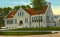 Lithgow Library in 1917
 -
 State House in 1965
 -
 Monument Park c. 1915
 -
 Post Office c. 1915
 -
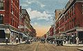 Water Street c. 1920
 -
 Hotel North in 1906
 -
 Kennebec River in 1909


References
Further reading
External links
- City of Augusta, Maine
- Lithgow Public Library
- University of Maine at Augusta
- City Data Profile
- Epodunk City Profile
Municipalities and communities of Kennebec County, Maine, United States | ||
|---|---|---|
| Cities |  | |
| Towns | ||
| Unorganized territory | ||
| CDPs | ||
| Other villages | ||
| Topics | |||||||
|---|---|---|---|---|---|---|---|
| States | |||||||
| Major cities | |||||||
| State capitals | |||||||
| Transportation |
| ||||||