
Palestinian territories: Difference between revisions
Sean.hoyland (talk | contribs) |
No edit summary |
||
| Line 1: | Line 1: | ||
{{pp-semi-protected|small=yes}} |
|||
{{Hatnote|This article is about the geography of Palestinian controlled areas in [[West Bank]] and [[Gaza strip]].}} |
|||
{{pp-move-indef}} |
|||
{{distinguish|Palestine (region)}} |
|||
{{About}} |
|||
{{Infobox country |
|||
[[File:Medieval Arab Palestine.jpg|right|thumb|An 1890 map of Palestine as described by medieval Arab geographers, with [[Jund Filastin]] administrative area]] |
|||
|native_name = |
|||
|conventional_long_name = <span style="line-height:1.33em;">Palestinian Territories</span> |
|||
|common_name = Palestine |
|||
|image_map = Palestine_election_map.PNG |
|||
|map_caption = Map showing areas of [[Palestinian National Authority]] control (the West Bank) and [[Governance of the Gaza Strip|Hamas Government]] control (Gaza Strip) in green. |
|||
|capital =Administrative centers: |
|||
[[Ramallah]] (West Bank), [[Gaza]] (Gaza Strip); [[East Jerusalem]] <small>(the proclaimed capital of the State of Palestine</small><ref name="Ref_a">The Palestine Basic Law, approved by the PLC in May 2002, states in the article 3 "Jerusalem is the Capital of Palestine" (source: [http://www.palestinianbasiclaw.org/2002-basic-law Palestinianbasiclaw.org]). [[Ramallah]] is the administrative capital and the location of government institutions as well as the foreign representative offices of [[Australia]], [[Brazil]], [[Canada]], [[Colombia]], [[Czech Republic]], [[Denmark]], [[Finland]], [[Germany]], [[Malta]], the [[Netherlands]], [[South Africa]], and [[Switzerland]]. Jerusalem's final status awaits future negotiations between Israel and the Palestinian Authority (see [http://www.publicpolicy.umd.edu/IPPP/Fall97Report/negotiating_jerusalem.htm "Negotiating Jerusalem", University of Maryland]{{dead link|date=September 2011}}). The [[United Nations]] and most countries do not accept Israel's claim over the whole of Jerusalem (see {{harvnb|Kellerman|1993|p=140}}) and maintain their embassies to Israel in other cities (see the [https://www.cia.gov/library/publications/the-world-factbook/geos/is.html CIA Factbook]).</ref> |
|||
|largest cities = [[Gaza]], [[Hebron]], [[Nablus]] and [[Jenin]] |
|||
|official_languages = [[Arabic language|Arabic]], [[Hebrew language|Hebrew]], and [[English language|English]] |
|||
|population_estimate = 3,935,249<ref name="Ref_b">[http://www.pcbs.gov.ps/Portals/_pcbs/child/demog.htm]{{dead link|date=September 2011}}</ref> |
|||
|population_estimate_year = 2009 (July) |
|||
|population_census = |
|||
|population_census_year = |
|||
|GDP_PPP = $12.95 billion |
|||
|GDP_PPP_rank = - |
|||
|GDP_PPP_year = 2009 |
|||
|GDP_PPP_per_capita = $2,900 |
|||
|GDP_PPP_per_capita_rank = - |
|||
|HDI = 0.645<ref>http://hdr.undp.org/en/media/Lets-Talk-HD-HDI_2010.pdf</ref> |
|||
|HDI_rank = 97th |
|||
|HDI_year = 2010 |
|||
|HDI_category = <span style="color:#fc0;">medium</span> |
|||
|established_event1 = |
|||
|established_date1 = |
|||
|currency = [[Jordanian dinar]]<sup>'''a'''</sup><br/>[[Egyptian Pound]]<sup>'''b'''</sup><br/>[[Israeli new sheqel]]<sup>'''c'''</sup> |
|||
|currency_code = JOD, EGP, ILS |
|||
|country_code = PS, IL |
|||
|time_zone = |
|||
|utc_offset = +2 |
|||
|time_zone_DST = |
|||
|utc_offset_DST = +3 |
|||
|cctld = [[.ps]], [[فلسطين.]] |
|||
|calling_code = [[+970]]<sup>'''d'''</sup> |
|||
|footnotes = {{Collapsible list|title=Notes a b c d|<sup>'''a'''</sup> Used in [[West Bank]] from 1950–present<br/><sup>'''b'''</sup> Used in [[Gaza Strip]] from 1951–present<br/><sup>'''c'''</sup> Used from 1985–present<br/><sup>'''d'''</sup> [[+972]] is also used}} |
|||
}} |
|||
[[Image:West Bank & Gaza Map 2007 (Settlements).png|right|thumb|300px|left|Map showing the West Bank and Gaza Strip in relation to central Israel (situation of 2007)]] |
|||
The '''Palestinian territories''' comprise the [[West Bank]] and the [[Gaza Strip]], politically under the jurisdiction of the [[Palestinian National Authority]] and the [[Hamas Government in Gaza]]. Since the [[Palestinian Declaration of Independence]] in 1988, the region is today recognized by three-quarters of the world's countries to be part of the [[State of Palestine]],<ref>[http://www.haaretz.com/news/diplomacy-defense/full-transcript-of-abbas-speech-at-un-general-assembly-1.386385] "Note that the term [[Palestine]] has historically referred to the region which today incorporates [[Israel]] as well as the Palestinian territories. The current position was expressed by [[Mahmoud Abbas]] in his September 2011 speech to the United Nations: 'When we adopted this program, we were taking a painful and very difficult step for all of us, especially those, including myself, who were forced to leave their homes and their towns and villages, carrying only some of our belongings and our grief and our memories and the keys of our homes to the camps of exile and the Diaspora in the 1948 [[Al-Nakba]], one of the worst operations of uprooting, destruction and removal of a vibrant and cohesive society that had been contributing in a pioneering and leading way in the cultural, educational and economic renaissance of the Arab Middle East. Yet, because we believe in peace and because of our conviction in international legitimacy, and because we had the courage to make difficult decisions for our people, and in the absence of absolute justice, we decided to adopt the path of relative justice - justice that is possible and could correct part of the grave historical injustice committed against our people. Thus, we agreed to establish the State of Palestine on only 22% of the territory of historical Palestine - on all the Palestinian Territory occupied by Israel in 1967.'"</ref> although this status is not recognized by the [[United Nations]], [[Israel]] and major [[Western world|Western nations]], including the [[United States]]. Effectively parts of the West Bank are currently governed by the [[Palestinian National Authority]], while [[Israeli-occupied territories|other parts]] are governed by Israeli military authorities, which the UN and international legal bodies often refer to as the ''Occupied Palestinian Territories''. The Gaza Strip is being [[Governance of the Gaza Strip|controlled]] by Hamas-led Palestinian Government. |
|||
'''Palestine''' ({{lang-el|Παλαιστίνη}}, ''Palaistinē''; {{lang-la|Palaestina}}; [[Hebrew language|Hebrew]]: פלשתינה ''Palestina''; {{lang-ar| فلسطين}} {{transl|ar|''Filasṭīn''}}, {{transl|ar|''Falasṭīn''}}, {{transl|ar|''Filisṭīn''}}) is a conventional name, among others, used to describe the geographic region between the [[Mediterranean Sea]] and the [[Jordan River]], and various adjoining lands.<ref name=ehrlich>Carl S. Ehrlich "Philistines" ''The Oxford Guide to People and Places of the Bible''. Ed. Bruce M. Metzger and Michael D. Coogan. Oxford University Press, 2001.</ref><ref name=PEF>{{cite web|title=The Palestine Exploration Fund|publisher=The [[Palestine Exploration Fund]]|url=http://www.pef.org.uk/oldsite/Paldef.htm|accessdate=2008-04-04}}</ref><ref>{{cite web|url=http://www.jewishencyclopedia.com/view.jsp?artid=31&letter=P |title=Palestine: |publisher=JewishEncyclopedia.com |date= |accessdate=2011-09-15}}</ref><ref>{{cite book |title= A History of Modern Palestine: One Land, Two Peoples|last= Pappe|first= Ilan|authorlink= Ilan Pappe|coauthors= |year= 2006|publisher= Cambridge University Press|isbn= 0521683157|url= http://www.amazon.com/dp/0521683157|accessdate=6 Feb 2011}}</ref><ref>{{cite book |title= A History of Palestine: From the Ottoman Conquest to the Founding of the State of Israel|last= Kramer|first= Gudrun|authorlink= Gudrun Kramer|year= 2008|publisher= Princeton University Press|isbn= 0691118973|url= http://www.amazon.com/dp/0691118973|accessdate=6 Feb 2011}}</ref><ref>{{cite book |title= The History of Ancient Palestine|last= Ahlstrom|first= Gosta|authorlink= Gosta Ahlstrom|year= 1993|publisher= Augsburg Fortress Publishers|isbn= 0800627709|url= http://www.amazon.com/dp/0800627709|accessdate=6 Feb 2011}}</ref> The region is also known as the [[Land of Israel]] ([[Hebrew language|Hebrew]]: ארץ־ישראל ''Eretz-Yisra'el''),<ref>{{cite book | author = Gideon Biger | title = The Boundaries of Modern Palestine, 1840-1947 | at = passim | year = 2004 | publisher = RoutledgeCurzon}}</ref> the [[Holy Land]] and the [[Southern Levant]],<ref>de Geus, 2003, p. 7.</ref> and historically has been known by other names including [[Canaan]], [[Zion]], [[Syria Palaestina]], [[Southern Syria]], [[Jund Filastin]] and [[Outremer]]. |
|||
The territories were part of the territory west of the [[Jordan River]] of [[Mandate Palestine]], formed in 1922. In March 1946, the territory east of the Jordan River, which had been ruled as a separate province of Mandate Palestine, became the independent kingdom of [[Transjordan]], though general international recognition took a bit longer. From the [[1948 Arab–Israeli War]] until the 1967 [[Six Day War]], the West Bank was [[Jordanian occupation of the West Bank and East Jerusalem|occupied]] and annexed by [[Jordan]] (annexation recognized only by UK and Pakistan) and the Gaza Strip [[Occupation of the Gaza Strip by Egypt|occupied]] by [[Egypt]], though limited authority was exercised in Gaza by the [[All-Palestine Government]] until 1959. The borders of Palestinian territories are currently considered to be delineated by the [[1949 Armistice Agreements]].<ref>[http://unispal.un.org/UNISPAL.NSF/0/9EC4A332E2FF9A128525643D007702E6 Egypt Israel Armistice Agreement] UN Doc S/1264/Corr.1 23 February 1949</ref> |
|||
The boundaries of the region have changed throughout history, and were first defined in modern times by the [[Franco-British boundary agreement (1920)]] and the [[Transjordan memorandum]] of 16 September 1922, during the [[British Mandate for Palestine]]. Today, the region comprises the country of [[Israel]] and the [[Palestinian disputed territories]].{{POV-statement|date=February 2012}}{{cn|date=February 2012}} |
|||
Since 1967 and until the establishment of the [[Palestinian National Authority]] in 1993, the territories became occupied by Israel, and effectively the term ''Occupied Palestinian territories'' was coined. In 1980 Israel annexed East Jerusalem, but [[United Nations Security Council Resolution 478]] declared it "null and void" and required that it be rescinded, stating that it was a violation of international law. The annexation lacks international recognition.<ref name=Amideast/> After losing it in 1967, Jordan renounced all territorial claims to East Jerusalem and the West Bank in 1988. |
|||
Palestine is also used to refer to the [[State of Palestine]] which, since the [[Palestinian Declaration of Independence]] in 1988, has referred to a state that is hoped by the Palestinians to be carved out of the [[Palestinian disputed territories]] on 22% of "historical Palestine" as determined by the British Mandate times in the early 20th century.<ref>The current position was expressed by [[Mahmoud Abbas]] in his September 2011 speech to the United Nations: "When we adopted this program, we were taking a painful and very difficult step for all of us, especially those, including myself, who were forced to leave their homes and their towns and villages, carrying only some of our belongings and our grief and our memories and the keys of our homes to the camps of exile and the Diaspora in the 1948 [[Al-Nakba]], one of the worst operations of uprooting, destruction and removal of a vibrant and cohesive society that had been contributing in a pioneering and leading way in the cultural, educational and economic renaissance of the Arab Middle East. Yet, because we believe in peace and because of our conviction in international legitimacy, and because we had the courage to make difficult decisions for our people, and in the absence of absolute justice, we decided to adopt the path of relative justice - justice that is possible and could correct part of the grave historical injustice committed against our people. Thus, we agreed to establish the State of Palestine on only 22% of the territory of historical Palestine - on all the Palestinian Territory occupied by Israel in 1967. [http://www.haaretz.com/news/diplomacy-defense/full-transcript-of-abbas-speech-at-un-general-assembly-1.386385]</ref> The State of Palestine is recognized today by approximately two-thirds of the world's countries, although this status is not recognized by the [[United Nations]], [[Israel]] and major [[Western world|Western nations]] such as the [[United States]]. |
|||
In 1993, parts of the Gaza Strip and the West Bank were transferred to the administration of the [[Palestinian National Authority]], becoming ''Palestinian territories''. In 2005, Israel pulled out all its remaining forces of Gaza Strip and dismantled its settlements. Yet, both West Bank and Gaza Strip are currently considered to be occupied by [[Israel]] according to the international community, although Israel has denied that it occupies the Gaza Strip.<ref>{{Cite book|last=Le More|first=Anne|title=International assistance to the Palestinians after Oslo: political guilt, wasted money|volume=1|series=Routledge studies on the Arab-Israeli conflict|publisher=[[Routledge]]|location=London and New York | isbn= 978-0-415-45385-1 |year=2008|page=27}}</ref><ref name=Amideast>{{cite web|url=http://www.amideast.org/westbank/country_info.htm|title=West Bank/Gaza (Occupied Palestinian Territories) Information|publisher=America-Mideast Educational and Training Services Inc. (AMIDEAST)|accessdate=2009-01-03}} {{Dead link|date=October 2010|bot=H3llBot}}</ref><ref name=UNOCHADec2009>{{cite web|url=http://www.ochaopt.org/documents/ocha_opt_the_humanitarian_monitor_2010_01_18_english.pdf|format=PDF|title=December Overview|publisher=The Humanitarian Monitor|date=December 2009|accessdate=2010-01-03|publisher=[[UNOCHA]]}}</ref> |
|||
== Etymology ==<!--linked--> |
|||
The [[Palestinian National Authority]] regards [[East Jerusalem]] as part of the West Bank, and consequently a part of the Palestinian territories, while Israel regards it as part of Israel as a result of its [[Jerusalem Law|annexation in 1980]]. According to the [[Supreme Court of Israel|Israeli Supreme Court]], the [[Fourth Geneva Convention]], which prohibits unilateral annexation of occupied territory, does not apply to East Jerusalem, as there was no "legitimate sovereign" there prior.{{Citation needed|date=August 2011}} The [[Palestinian National Authority]], which maintains a territorial claim to East Jerusalem, never exercised sovereignty over the area. However, this reasoning has not been recognized by any other country, since unilateral annexation of territory conquered during war contravenes the Fourth Geneva Convention.<ref>[http://books.google.com/books?id=ueDO1dJyjrUC&pg=PA257&dq=territorial+annexation+through+conflict+Jerusalem&hl=en&ei=Tse3TMHICIX6lwfJxJ2WCQ&sa=X&oi=book_result&ct=result&resnum=1&ved=0CCUQ6AEwAA#v=onepage&q=territorial%20annexation%20through%20conflict%20Jerusalem&f=false The Right of Conquest] By Sharon Korman</ref><ref>{{cite book|last=Dugard|first=John|title=Recognition and the United Nations |year=1987|publisher=Cambridge: Grotius Publications Limited|isbn=0-521-46322-X|pages=111–115}}</ref> |
|||
{{See|Definitions of Palestine|History of the name Palestine}} |
|||
The term ''Peleset'' ([[Transliteration of Ancient Egyptian|transliterated]] from [[Egyptian hieroglyphs|hieroglyphs]] as ''P-r-s-t'') is found in numerous Egyptian documents referring to a neighboring people or land starting from c.1150 BCE during the [[Twentieth dynasty of Egypt]]. The first mention is thought to be in texts of the temple at [[Medinet Habu (temple)|Medinet Habu]] which record a people called the Peleset among the [[Sea Peoples]] who invaded [[Egypt]] in [[Ramesses III]]'s reign.<ref name=Fahlbuschp185>Fahlbusch et al., 2005, p. 185.</ref> The [[Assyria]]ns called the same region ''Palashtu'' or ''Pilistu'', beginning with [[Adad-nirari III]] in the Nimrud Slab in c.800 BCE through to emperor [[Sargon II]] in his Annals approximately a century later.<ref name=Sharonp4>Sharon, 1988, p. 4.</ref><ref name=Roomp285/><ref name="ehrlich" /> Neither the Egyptian or Assyrian sources provided clear regional boundaries for the term. |
|||
The Hamas [[Battle of Gaza (2007)|takeover]] of Gaza politically divided the Palestinian territories, with Abbas’s [[Fatah]] left largely ruling the West Bank and recognized internationally as the official [[Palestinian Authority]],<ref name=alarabiya0701>[http://english.alarabiya.net/articles/2012/01/07/186930.html]</ref> while Hamas has secured its control over the [[Governance of the Gaza Strip|Gaza Strip]]. In April 2011, the Palestinian parties signed an agreement of reconciliation, but its implementation has stalled since.<ref name=alarabiya0701/> |
|||
The first clear use of the term Palestine to refer to the entire area between Phoenicia and Egypt was in 5th century BC [[Ancient Greece]].<ref>{{cite journal |title=Palestine and Israel |journal=Bulletin of the American Schools of Oriental Research |first=David M. |last=Jacobson |editor-first=James M. |editor-last=Weinstein |number=313 |year=1999 |month=February |publisher=The American Schools of Oriental Research |issn=0003097X |pages=65–74 |jstor=1357617 |accessdate=February 28, 2012|quote="The earliest occurrence of this name in a Greek text is in the mid-fifth century b.c., Histories of Herodotus, where it is applied to the area of the Levant between Phoenicia and Egypt."..."The first known occurrence of the Greek word Palaistine is in the Histories of Herodotus, written near the mid-fifth century B.C. Palaistine Syria, or simply Palaistine, is applied to what may be identified as the southern part of Syria, comprising the region between Phoenicia and Egypt. Although some of Herodotus' references to Palestine are compatible with a narrow definition of the coastal strip of the Land of Israel, it is clear that Herodotus does call the "whole land by the name of the coastal strip."..."It is believed that Herodotus visited Palestine in the fifth decade of the fifth century B.C."..."In the earliest Classical literature references to Palestine generally applied to the Land of Israel in the wider sense."}} and {{cite web |url= http://cojs.org/cojswiki/When_Palestine_Meant_Israel,_David_Jacobson,_BAR_27:03,_May/Jun_2001.|title= When Palestine Meant Israel|author= David Jacobson|date= May/Jun 2001|publisher= BAR 27:03|accessdate=2 March 2012|quote= As early as the Histories of Herodotus, written in the second half of the fifth century B.C.E., the term Palaistinê is used to describe not just the geographical area where the Philistines lived, but the entire area between Phoenicia and Egypt—in other words, the Land of Israel. Herodotus, who had traveled through the area, would have had firsthand knowledge of the land and its people. Yet he used Palaistinê to refer not to the Land of the Philistines, but to the Land of Israel}}</ref> [[Herodotus]] wrote of a 'district of Syria, called ''Palaistinê''" in ''[[Histories (Herodotus)|The Histories]]'', the first historical work clearly defining the region, which included the [[Judean mountains]] and the [[Jordan Rift Valley]].<ref>Jacobson, David M., ''Palestine and Israel'', Bulletin of the American Schools of Oriental Research, No. 313 (Feb., 1999), pp. 65–74</ref><ref>The Southern and Eastern Borders of Abar-Nahara Steven S. Tuell Bulletin of the American Schools of Oriental Research, No. 284 (Nov., 1991), pp. 51–57</ref><ref>Herodotus' Description of the East Mediterranean Coast Anson F. Rainey Bulletin of the American Schools of Oriental Research, No. 321 (Feb., 2001), pp. 57–63</ref><ref>In his work, Herodotus referred to the practice of [[History of male circumcision|male circumcision]] associated with the Hebrew people: "the [[Colchis|Colchians]], the [[Egyptians]], and the [[Ethiopians]], are the only nations who have practised circumcision from the earliest times. The [[Phoenicians]] and the Syrians of Palestine themselves confess that they learnt the custom of the Egyptians.... Now these are the only nations who use circumcision." [http://classics.mit.edu/Herodotus/history.mb.txt The History of Herodotus]</ref><ref>Beloe, W., Rev., ''Herodotus'', (tr. from Greek), with notes, Vol.II, London, 1821, p.269 "It should be remembered that Syria is always regarded by Herodotus as synonymous with [[Assyria]]. What the Greeks called Palestine the Arabs call Falastin, which is the Philistines of Scripture."</ref><ref>[http://www.losttrails.com/herald/messages/33.shtml Elyahu Green, Geographic names of places in Israel in Herodotos] This is confirmed by [[George Rawlinson]] in the third book (Thalia) of ''The Histories'' where ''Palaestinian Syrians'' are part of the fifth tax district spanning the territory from [[Phoenicia]] to the borders of Egypt, but excludes the ''kingdom of Arabs'' who were exempt from tax for providing the Assyrian army with water on its march to Egypt. These people had a large city called Cadytis, identified as Jerusalem.</ref> Approximately a century later, [[Aristotle]] used a similar definition in ''[[Meteorology (Aristotle)|Meteorology]]'', writing "Again if, as is fabled, there is a lake in Palestine, such that if you bind a man or beast and throw it in it floats and does not sink, this would bear out what we have said. They say that this lake is so bitter and salt that no fish live in it and that if you soak clothes in it and shake them it cleans them," understood by scholars to be a reference to the [[Dead Sea]].<ref>[http://classics.mit.edu/Aristotle/meteorology.2.ii.html Meteorology By Aristotle]</ref> Later writers such as [[Polemon of Athens|Polemon]] and [[Pausanias (geographer)|Pausanias]] also used the term to refer to the same region. This usage was followed by Roman writers such as [[Ovid]], [[Tibullus]], [[Pomponius Mela]], [[Pliny the Elder]], [[Dio Chrysostom]], [[Statius]], [[Plutarch]] as well as Roman Judean writers [[Philo of Alexandria]] and [[Josephus]].<ref name=Robinson/> Other writers, such as [[Strabo]], a prominent Roman-era geographer (although he wrote in Greek), referred to the region as ''Coele-Syria'' around 10-20 CE.<ref>Studies in Hellenistic Judaism :Louis H. Feldman</ref><ref>The Hellenistic settlements in Syria, the Red Sea Basin, and North Africa :Getzel M. Cohen</ref> The term was first used to denote an official province in c.135 CE, when the [[Roman Empire|Roman authorities]], following the suppression of the [[Bar Kokhba Revolt]], combined [[Iudaea Province]] with [[Galilee]] and other surrounding cities such as [[Ashkelon]] to form "[[Syria Palaestina]]" ({{lang|la|Syria Palaestina}}), which some scholars state was in order to complete the dissociation with Judaea.<ref name = "Lehmann">{{cite web |
|||
==Name== |
|||
| url = http://www.usd.edu/~clehmann/erp/Palestine/history.htm#135-337 |
|||
{{see also|Timeline of the name Palestine}} |
|||
| title = Palestine: History: 135–337: Syria Palaestina and the Tetrarchy |
|||
There are disagreements over what the Palestinian territories should be called. |
|||
| accessdate = 2008-07-06 |
|||
| last = Lehmann |
|||
| first = Clayton Miles |
|||
| year = 1998 |
|||
| month = Summer |
|||
| work = The On-line Encyclopedia of the Roman Provinces |
|||
| publisher = University of South Dakota |
|||
}} |
|||
</ref><ref name=Sharonp4n>Sharon, 1998, p. 4. According to Moshe Sharon: "Eager to obliterate the name of the rebellious [[Iudaea Province|Judaea]]", the Roman authorities (General Hadrian) renamed it ''Palaestina'' or ''Syria Palaestina''.</ref> |
|||
The [[Hebrew language|Hebrew]] name ''Peleshet'' ({{lang|he|פלשת}} ''Pəlésheth'')- usually translated as ''Philistia'' in English, is used in the [[Bible]] more than 250 times. The Greek word ''Palaistinē'' (Παλαιστίνη, "''Palaistine''") is generally accepted to be a translation of the Semitic name for Philistia; however another term – ''Land of Philistieim'' (''Γη των Φυλιστιειμ'', transliteration from Hebrew) – was used in the [[Septuagint]], the second century BCE Greek translation of the [[Hebrew Bible]], to refer to Philistia.<ref>{{cite journal |title=Palestine and Israel |journal=Bulletin of the American Schools of Oriental Research |first=David M. |last=Jacobson |editor-first=James M. |editor-last=Weinstein |number=313 |year=1999 |month=February |publisher=The American Schools of Oriental Research |issn=0003097X |pages=65–74 |jstor=1357617 |accessdate=February 28, 2012}}</ref> In the [[Torah]] / [[Pentateuch]] the term Philistia is used 10 times and its boundaries are undefined. The later [[Books of the Bible|Historical books]] (see [[Deuteronomistic history]]) include most of the biblical references, almost 200 of which are in the [[Book of Judges]] and the [[Books of Samuel]], where the term is used to denote the southern coastal region to the west of the ancient [[Kingdom of Judah]].<ref>Lewis, 1993, p. 153.</ref><ref name=Sharonp4/><ref name=Roomp285>Room, 1997, p. 285.</ref><ref name=Robinson>Robinson, Edward, ''Physical geography of the Holy Land'', Crocker & Brewster, Boston, 1865, p.15. Robinson, writing in 1865 when travel by Europeans to the Ottoman Empire became common asserts that, "Palestine, or Palestina, now the most common name for the Holy Land, occurs three times in the English version of the Old Testament; and is there put for the [[Hebrew]] name פלשת, elsewhere rendered Philistia. As thus used, it refers strictly and only to the country of the [[Philistines]], in the southwest corner of the land. So, too, in the Greek form, Παλαςτίνη), it is used by [[Josephus]]. But both Josephus and [[Philo]] apply the name to the whole land of the Hebrews ; and Greek and Roman writers employed it in the like extent."</ref> |
|||
The [[United Nations]], the [[International Court of Justice]], the [[European Union]], [[International Committee of the Red Cross]] and the government of the [[United Kingdom]] all refer to the "Occupied Palestinian Territories".<ref>[http://www.fco.gov.uk/en/about-the-fco/country-profiles/middle-east-north-africa/palestine-national-authority UK Government Foreign Office]{{Dead link|date=June 2010}}</ref><ref>{{cite web|url=http://www.publications.parliament.uk/pa/cm200304/cmselect/cmintdev/230/230.pdf |title=House of Commons International Development Committee - FINAL REPORT Vol I 26 January 2004 |format=PDF |date= |accessdate=2010-06-30}}</ref><ref>[http://www.icrc.org/Web/Eng/siteeng0.nsf/html/palestine-report-131207 International Committee of the Red Cross]{{Dead link|date=June 2010}}</ref> Journalists also use the description to indicate lands outside the ''[[Green Line (Israel)|Green Line]]''.{{Citation needed|date=April 2010}} The term is often used interchangeably with the term [[Israeli-occupied territories|occupied territories]], although this term is also applied to the [[Golan Heights]], which is internationally recognized as part of [[Syria]] and not claimed by the Palestinians. The confusion stems from the fact that all these territories were captured by Israel during the 1967 [[Six-Day War]] and are treated by the UN as territory occupied by Israel. |
|||
During the [[Byzantine Empire|Byzantine period]], the entire region (Syria Palestine, [[Samaria]], and the [[Galilee]]) was named ''Palaestina'', subdivided into provinces Palaestina I and II.<ref name=Kaegip41/> The Byzantines also renamed an area of land including the [[Negev]], [[Sinai]], and the west coast of the Arabian Peninsula as ''Palaestina Salutaris'', sometimes called ''Palaestina III''.<ref name=Kaegip41>Kaegi, 1995, p. 41.</ref> The [[Arabic language|Arabic]] word for Palestine is فلسطين (commonly transcribed in English as ''Filistin'', ''Filastin'', or ''Falastin'').<ref name=Marshallp559>Marshall Cavendish, 2007, p. 559.</ref> Moshe Sharon writes that when the [[Arab]]s took over [[Greater Syria]] in the 7th century, [[Place names of Palestine|place names]] that were in use by the Byzantine administration before them, generally continued to be used. Hence, he traces the emergence of the Arabic form ''Filastin'' to this adoption, with Arabic inflection, of Roman and [[Hebrew language|Hebrew]] ([[Semitic]]) names.<ref name=Sharonp4/> Jacob Lassner and Selwyn Ilan Troen offer a different view, writing that ''Jund Filastin'', the full name for the administrative province under the rule of the Arab [[caliphates]], was traced by Muslim geographers back to the Philistines of the Bible.<ref name=Lassnerp54>Lassner and Troen, 2007, pp. 54–55.</ref> The use of the name "Palestine" in English became more common after the European renaissance.<ref>Gudrun Krämer (2008) ''A History of Palestine: From the Ottoman Conquest to the Founding of the State of Israel'' Translated by Gudrun Krämer and Graham Harman Princeton University Press, ISBN 0-691-11897-3 p 16</ref> It was officially revived by the British after the fall of the [[Ottoman Empire]] and applied to the territory that was placed under [[British Mandate for Palestine|The Palestine Mandate]]. |
|||
Other terms used to describe these areas collectively include 'the disputed territories', '[[Israeli-occupied territories]]', and 'the occupied territories'. Further terms include "[[Yesha]]" (Judea-Samaria-Gaza), Yosh (Judea and Samaria), the Katif Strip (Gaza Strip), "administered territories", "territories of undetermined permanent status", "1967 territories", and simply "the territories". |
|||
Some other terms that have been used to refer to all or part of this land include [[Canaan]], [[Greater Israel]], [[Greater Syria]], the [[Holy Land]], [[Iudaea Province]], [[Judea]],<ref>[http://encarta.msn.com/encnet/refpages/RefArticle.aspx?refid=761579829 Judea]{{dead link|date=August 2010}}</ref> [[Israel]], "Israel HaShlema", [[Kingdom of Israel (united monarchy)|Kingdom of Israel]], [[Kingdom of Jerusalem]], [[Land of Israel]] (Eretz Yisrael or Ha'aretz), [[Zion]], ''Retenu'' (Ancient Egyptian), [[Southern Syria]], and [[Syria Palestina]]. |
|||
Many Arab and Islamic leaders,{{Who|date=October 2009}} including some Palestinians,{{Who|date=October 2009}} use the designation 'Palestine' and 'occupied Palestine' to imply a Palestinian political or religious claim to [[sovereignty]] over the whole former territory of the British Mandate west of the [[Jordan River]], including all of Israel.<ref>see for example:[http://www.yale.edu/lawweb/avalon/mideast/hamas.htm The Covenant of the Islamic Resistance Movement 18 August 1988]</ref> Many{{Who|date=October 2009}} of them view the land of Palestine as an Islamic [[Waqf]] (trust) for future Muslim generations. A parallel exists in the aspirations of David Ben-Gurion,<ref name="Britlabour and Zionism">{{Cite book|title=The British labour movement and Zionism, 1917-1948|year=1983|publisher=Routledge|isbn=978-0-7146-3162-2|page=138|coauthors=Joseph Gorny, Yosef Gorni|quote=The Jewish people have always regarded, and will continue to regard Palestine as a whole, as a single country which is theirs in a national sense and will become theirs once again. No Jew will accept partition as a just and rightful solution.}}</ref> Menachem Begin,<ref name="Chomsky fateful triangle">{{Cite book|last=Chomsky|first=Noam|title=Fateful triangle: the United States, Israel, and the Palestinians|year=1999|publisher=South End Press|isbn=978-0-89608-601-2|page=161|authorlink=Noam Chomsky}}</ref><ref name="Avi Shlaim">{{Cite book|last=Shlaim|first=Avi|title=The Iron Wall: Israel and the Arab World|year=2008|publisher=Paw Prints|isbn=978-1-4352-9513-1|page=670}}</ref> and other Zionists and Jewish religious leaders{{Who|date=October 2009}} to establish Jewish sovereignty over all of [[Greater Israel]] in trust for the Jewish people.<ref>see for example: [http://www.ynetnews.com/articles/0,7340,L-3596946,00.html Open a Bible]</ref><ref>The [http://www.knesset.gov.il/elections/knesset15/elikud_m.htm Likud—Platform] states "The Government of Israel flatly rejects the establishment of a Palestinian Arab state west of the Jordan River. The Palestinians can run their lives freely in the framework of self-rule, but not as an independent and sovereign state."</ref> However, this dispute is not related to religion for many Arabs, but simply an issue of rights, as the land was inhabited by Arabs (as well as a minority of Jews) before the Zionist movement began. |
|||
== History == |
|||
Many [[Israelis]] {{Who|date=February 2010}} object to the term "Occupied Palestinian Territories", and similar descriptions, because they maintain such designations disregard Israeli claims to the West Bank and Gaza, or prejudice negotiations involving possible border changes, arguing that the armistice line agreed to after the [[1948 Arab-Israeli War]] was not intended as a permanent border. [[Dore Gold]] wrote, "It would be far more accurate to describe the West Bank and Gaza Strip as "disputed territories" to which both Israelis and Palestinians have claims."<ref>[From 'Occupied Territories' to 'Disputed Territories,' Dore Gold, Jerusalem Center for Public Affairs. http://www.jcpa.org/JCPA/Templates/ShowPage.asp?DBID=1&LNGID=1&TMID=111&FID=380&PID=1864&IID=1115]</ref> |
|||
{{Main|History of Palestine}} {{See|Time periods in the region of Palestine}} |
|||
== |
=== Overview === |
||
Situated at a strategic location between [[Egypt]], [[Greater Syria|Syria]] and [[Arabia]], and the birthplace of [[Judaism]] and [[Christianity]], the region has a long and tumultuous history as a crossroads for religion, culture, commerce, and politics. The region has been controlled by numerous different peoples, including [[Ancient Egyptians]], [[Canaanites]], [[Ancient Israelites]], [[Assyrians]], [[Babylonians]], [[Achaemenid Empire|Persians]], [[Ancient Greeks]], [[Ancient Rome|Romans]], [[Byzantine Empire|Byzantines]], the [[Sunni]] [[Arab Caliphate]], the [[Shia]] [[Fatimid Caliphate]], [[Crusaders]], [[Ayyubids]], [[Mameluks]], [[Ottomans]], the [[United Kingdom|British]] and modern [[Israelis]] and [[Palestinians]]. Modern archaeologists and historians of the region refer to their field of study as [[Syro-Palestinian archaeology]]. |
|||
{{See also|Borders of Israel}} |
|||
[[Image:Gz-map2.png|left|thumb|100px|Map of the Gaza Strip]] |
|||
The Palestinian Territories consist of two (or perhaps three) distinct areas: the Gaza Strip, the West Bank and East Jerusalem. Israel regards East Jerusalem not to be a part of the West Bank, but regards it is as part of a unified Jerusalem, which it unilaterally considers the capital of the state. The eastern limit of the West Bank is the border with [[Jordan]]. The [[Israel–Jordan Treaty of Peace|Israel–Jordan peace treaty]] defined that border as the [[international border]], and Jordan renounced all claims to territory west of it. The border segment between Jordan and the West Bank was left undefined pending a definitive agreement on the status of the territory.<ref>http://untreaty.un.org/unts/144078_158780/11/6/4045.pdf</ref> |
|||
{{Timeline of Palestine Sovereign Powers}} |
|||
The southern limit of the Gaza Strip is the border with [[Egypt]]. Egypt renounced all claims to land north of the international border, including the Gaza Strip, in the [[Israel-Egypt Peace Treaty|Israel-Egypt peace treaty]]. The Palestinians were not parties to either agreement. |
|||
=== Ancient period === |
|||
The natural geographic boundary of the West Bank, as the name implies, is the [[Jordan River]]. The Gaza Strip is bounded by the [[Mediterranean Sea]]. |
|||
[[File:1759 map Holy Land and 12 Tribes.jpg|thumb|250px|''A 1759 map of The Holy Land, or Palestine. The map includes historical depictions of the Ancient Kingdoms of Judah and Israel, in which the 12 Tribes have been distinguished according to the Holy Scriptures.'' Tobias Conrad [[Lotter]], [[Geographer]]. [[Augsburg]], [[Germany]], 1759'']] |
|||
The region was among the earliest in the world to see human habitation, agricultural communities and [[civilization]]. During the [[Bronze Age]], independent [[Canaan]]ite city-states were established, and were influenced by the surrounding civilizations of ancient Egypt, [[Mesopotamia]], [[Phoenicia]], [[Minoan civilization|Minoan]] Crete, and Syria. Between 1550-1400 BCE, the Canaanite cities became vassals to the Egyptian [[New Kingdom]] who held power until the 1178 BCE [[Battle of Djahy|Battle of Djahy (Canaan)]] during the wider [[Bronze Age collapse]]. The [[Philistines]] arrived and mingled with the local population, and according to Biblical tradition, the [[United Monarchy|United Kingdom of Israel]] was established in 1020 BC and split within a century to form the northern [[Kingdom of Israel (Samaria)|Kingdom of Israel]], and the southern [[Kingdom of Judah]]. The region became part of the [[Neo-Assyrian Empire]] from c740 BCE, which was itself replaced by the [[Neo-Babylonian Empire]] in c.627 BCE. According to the bible, a war with Egypt culminated in 586 BCE when Jerusalem was destroyed by the Babylonian king [[Nebuchadnezzar II]] and the local leaders of the region of Judea were [[Babylonian captivity|deported to Babylonia]]. In 539 BCE, the Babylonian empire was replaced by the [[Achaemenid Empire]]. According to the [[bible]] and implications from the [[Cyrus Cylinder]], the exiled population of Judea was allowed to [[The Return to Zion|return to Jerusalem]]. |
|||
=== Classical antiquity === |
|||
[[Image:We-map.png|right|thumb|120px|Map of the West Bank]] |
|||
[[File:Israel Byzantine 5c.jpg|200px|thumb|left|5th century CE: Byzantine provinces of ''Palaestina I'' (Philistia, Judea and Samaria) and ''Palaestina II'' (Galilee and Perea)]] |
|||
It is now generally accepted, at least as a basis for negotiation between the sides, that the boundaries between the West Bank and the Gaza Strip and the [[Israel|State of Israel]] are what has historically been referred to as the [[Green Line (Israel)|Green Line]].{{Citation needed|date=March 2011}} The Green Line represents the armistice lines under the [[1949 Armistice Agreements]], which brought an end to the [[1948 Arab-Israeli War]] and expressly declared armistice lines, not international borders. |
|||
In the [[330s BCE]], Macedonian ruler [[Alexander the Great]] conquered the region, and the region changed hands numerous times during the [[wars of the Diadochi]]. ultimately joining the [[Seleucid Empire]] between 219-200 BCE. In 116 BCE, a Seleucid civil war resulted in the independence of certain regions including the minor [[Hasmonean]] principality in the [[Judean Mountains]]. From 110 BCE, the [[Hasmoneans]] extended their authority over much of Palestine, creating a [[Judean]]-[[Samaritan]]-[[Idumaean]]-[[Ituraean]]-[[Galilean]] alliance. The Judean (Jewish, see [[Ioudaioi]]) control over the wider region resulted in it also becoming known as [[Judaea]], a term which had previously only referred to the smaller region of the [[Judean Mountains]]. Between 73-63 BCE, the [[Roman Republic]] extended its influence in to the region in the [[Third Mithridatic War]], conquering of Judea in 63 BCE, and splitting the former Hasmonean Kingdom into five districts. The three year [[Ministry of Jesus]], culminating in his [[Crucifixion of Jesus|crucifixion]], is estimated to have occurred from 28-30 CE, although the [[historicity of Jesus]] is disputed by scholars. In 70 CE, [[Titus]] [[Siege of Jerusalem (70)|sacked Jerusalem]], resulting in the dispersal of the city's Jews and Christians to [[Yavne]] and [[Pella]]. In 132 CE, [[Hadrian]] joined the province of Iudaea with [[Galilee]] to form new province of [[Syria Palaestina]], and Jerusalem was renamed "[[Aelia Capitolina]]". Between 259-272, the region fell under the rule of [[Odaenathus]] as King of the [[Palmyrene Empire]]. Following the victory of Christian emperor [[Constantine I|Constantine]] in the [[Civil Wars of the Tetrarchy (306–324)]], the Christianization of the Roman Empire began, and in 326, [[Constantine I|Constantine]]'s mother [[Saint Helena]] visited [[Jerusalem]] and began the construction of churches and shrines. Palestine became a center of [[Christianity]], attracting numerous monks and religious scholars. The [[Samaritan Revolts]] during this period caused their near extinction. In 614 CE, Palestine was annexed by another Persian dynasty; the [[Sassanids]], until returning to Byzantine control in 628 CE.<ref>Greatrex-Lieu(2002), II, 196</ref> |
|||
=== Middle Ages === |
|||
Between the Armistice of 1949 and the [[Six-Day War]] of 1967, the West Bank and East Jerusalem were occupied and annexed by Jordan and the Gaza Strip was occupied (but not annexed) by Egypt. The term "Palestinian" began to be applied exclusively to the Arab population of these areas only after Israel's victory in the 1967 War, and consequently the terms "Palestinian Territories" and "Occupied Palestinian Territories" also gained wide usage. Until the start of serious negotiations for a settlement of the Israeli-Palestinian issues (the [[Peace process in the Israeli–Palestinian conflict|Peace Process]]), the Palestinians refrained from defining the boundaries of what they called "the occupied territories," and which some even called "occupied Palestine", which implied a potential Palestinian claim to the whole of Israel. It was in the context of the negotiations that the term "1967 borders" came to be used, as a basis for negotiation. "The 1967 borders" are in fact the 1949 armistice lines (which is the Green Line), which all Arab countries and Palestinians at the time insisted were to be temporary and with no other legal status. The Palestinian negotiators claim a return to those lines as the boundary for a future Palestinian state. The Palestinians also claim that East Jerusalem is a part of the occupied West Bank within the boundaries of the "1967 borders". The [[Arab League]] has supported these boundaries as the borders of the future [[State of Palestine]] in the 2002 [[Arab Peace Initiative]]. |
|||
[[File:White to.jpg|thumb|upright|Tower of Ramla, constructed in 1318]] |
|||
Palestine joined the Islamic Empire following at the 636 CE [[Battle of Yarmouk]] during the [[Muslim conquest of Syria]]. In 661 CE, with the assassination of [[Ali]], [[Muawiyah I]] became the uncontested Caliph of the Islamic World after being crowned in [[Jerusalem]]. In 691, the [[Dome of the Rock]] became the world's first great work of Islamic architecture. The [[Umayyad]] were replaced by the [[Abbasids]] in 750. From 878 Palestine was ruled from Egypt by semi-autonomous rulers for almost a century, beginning with [[Ahmad ibn Tulun]], and ending with the [[Ikhshidid]] rulers who were both buried in Jerusalem. The [[Fatimid]]s conquered the region in 969. In 1073 Palestine was captured by the [[Great Seljuq Empire]], only to be recaptured by the [[Fatimid]]s in 1098, who then lost the region to the [[Crusaders]] in 1099. Their control of Jerusalem and most of Palestine lasted almost a century until defeat by [[Saladin]]'s forces in 1187, after which most of Palestine was controlled by the Ayyubids. A rump crusader state in the northern coastal cities survived for another century, but, despite seven further crusades the crusaders were no longer a significant power in the region. THe [[Fourth Crusade]] led directly to the decline of the [[Byzantine Empire]], dramatically reducing Christian influence throughout the region. The [[Mamluk Sultanate (Cairo)|Mamluk Sultanate]] was indirectly created in [[Egypt]] as a result of the [[Seventh Crusade]]. The [[Mongol Empire]] reached Palestine for the first time in 1260, beginning with the [[Mongol raids into Palestine]] under [[Nestorian Christian]] general [[Kitbuqa]] and reaching an apex at the pivotal [[Battle of Ain Jalut]]. In 1486, hostilities broke out between the Mamluks and the [[Ottoman Turks]] in a battle for control over western Asia and the Ottomans captured Palestine in 1516. |
|||
=== Modern period === |
|||
==History== |
|||
{{ |
{{See|History of Zionism|British Mandate for Palestine|History of Israel}} |
||
[[File: |
[[File:UN Partition Plan For Palestine 1947.svg|thumb|150px|1947 UN Partition Plan for ''State of Palestine'', founded within the greater Palestine region]] |
||
[[File:Samuelarrival.jpg|thumb|left|upright|The new era in Palestine. The arrival of Sir Herbert Samuel, H.B.M. High Commissioner with Col. Lawrence, Emir Abdullah, Air Marshal [[Geoffrey Salmond|Salmond]] and Sir Wyndham Deedes, 1920.]] |
|||
In 1832 Palestine was conquered by [[Muhammad Ali of Egypt|Muhammad Ali]]'s Egypt, but in 1840 Britain intervened and returned control of the Levant to the Ottomans in return for further [[Capitulations of the Ottoman Empire|capitulations]]. The end of the 19th century saw the beginning of [[Zionist]] immigration and the [[Revival of the Hebrew language]]. The movement was publicly supported by [[Great Britain]] during [[World War I]] with the [[Balfour Declaration of 1917]]. The British captured Jerusalem a month later, and were formally awarded a [[British Mandate for Palestine|mandate]] in 1922. The non-Jewish Palestinians revolted in 1920, 1929 and 1936. In 1947, following [[World War II]] and the [[Holocaust]], the British Government announced their desire to terminate the Mandate, and the [[United Nations]] [[UN General Assembly|General Assembly]] voted to [[United Nations Partition Plan for Palestine|partition]] the territory into a Jewish state and an Arab state. The Jewish leadership accepted the proposal but the Arab Higher Committee rejected it; a [[1947-1948 Civil War in Mandatory Palestine|civil war]] began immediately, and [[Israel]] was declared in 1948. The [[1948 Palestinian exodus|700,000 Palestinians]] who fled or were driven from their homes were unable to return following the [[Lausanne Conference, 1949]]. In the [[1948 Arab-Israeli War]], Israel captured and incorporated a further 26% of the Mandate territory, Jordan [[Occupation of the West Bank and East Jerusalem by Jordan|captured the region today known as the West Bank]] and the [[Gaza Strip]] was [[Occupation of the Gaza Strip by Egypt|captured by Egypt]]. In the course of the [[Six Day War]] in June 1967, Israel captured the rest of Mandate Palestine from Jordan and Egypt, and began a policy of [[Israeli settlement]]s. From 1987 to 1993, the [[First Intifada|First Palestinian Intifada]] against Israel took place, ending with the [[1993 Oslo Peace Accords]]. In 2000, the Second or [[Al-Aqsa Intifada]] began, and Israel built a [[Israeli West Bank barrier|security barrier]]. Following [[Israel's unilateral disengagement plan of 2004]], it withdrew all settlers and most of the military presence from the Gaza strip, but maintained control of the air space and coast. |
|||
== Boundaries == |
|||
In 1922 after the collapse of the [[Ottoman Empire]] that ruled [[Ottoman Syria|Greater Syria]] for four centuries (1517–1917), the [[British Mandate for Palestine]] was established. Large-scale Jewish immigration from abroad, mainly from [[Eastern Europe]] took place during the British Mandate, though Jewish immigration started during the Ottoman period.<ref>[http://www.un.org/depts/dpa/ngo/history.html History]{{dead link|date=September 2011}}, Civil Society Network on the Question of Palestine, Division for Palestinian Rights, United Nations.</ref><ref name="Mark A. Tessler">[http://www.sourcewatch.org/index.php?title=Mark_A._Tessler Mark A. Tessler], [http://books.google.com/books?id=3kbU4BIAcrQC&lpg=PP1&ots=Szm5WrG91i&dq=Mark%20A.%20Tessler&pg=PP1#v=onepage&q&f=false ''A History of the Israeli-Palestinian conflict.''] page 211</ref> The future of Palestine was hotly disputed between Arabs and Jews. In 1947, the total Jewish ownership of land in Palestine was 1,850,000 dunams or 1,850 square kilometers, which is 7.04% of the total land of Palestine.<ref>[[British_mandate#Land_ownership_of_the_British_Mandate_of_Palestine]]</ref> Public property or "crown lands", the bulk of which was in the Negev, belonging to the government of Palestine may have made up as much as 70% of the total land; with the Arabs, Christians and others owning the rest.<ref>Alexander Safian, [http://www.meforum.org/article/370 Can Arabs Buy Land in Israel?], ''Middle East Quarterly'' Volume IV, Number 4, December 1997; citing Moshe Aumann, Land Ownership in Palestine 1880–1948, Israel Academic Committee on the Middle East (undated, approximately 1970). The Negev statement is in Aumann.</ref> |
|||
The boundaries of Palestine have varied throughout history.<ref name=Note1>According to the Jewish Encyclopedia published between 1901 and 1906: "Palestine extends, from 31° to 33° 20′ N. latitude. Its southwest point (at Raphia = Tell Rifaḥ, southwest of Gaza) is about 34° 15′ E. longitude, and its northwest point (mouth of the Liṭani) is at 35° 15′ E. longitude, while the course of the Jordan reaches 35° 35′ to the east. The west-Jordan country has, consequently, a length of about 150 English miles from north to south, and a breadth of about 23 miles at the north and 80 miles at the south. The area of this region, as measured by the surveyors of the English Palestine Exploration Fund, is about 6,040 square miles. The east-Jordan district is now being surveyed by the German Palästina-Verein, and although the work is not yet completed, its area may be estimated at 4,000 square miles. This entire region, as stated above, was not occupied exclusively by the Israelites, for the plain along the coast in the south belonged to the Philistines, and that in the north to the Phoenicians, while in the east-Jordan country the Israelitic possessions never extended farther than the Arnon (Wadi al-Mujib) in the south, nor did the Israelites ever settle in the most northerly and easterly portions of the plain of Bashan. To-day the number of inhabitants does not exceed 650,000. Palestine, and especially the Israelitic state, covered, therefore, a very small area, approximating that of the state of Vermont." From the Jewish Encyclopedia [http://www.jewishencyclopedia.com/view.jsp?artid=31&letter=P&search=palestine#133 Boundaries and Extent]</ref><ref name=Note2>According to the [[Encyclopædia Britannica Eleventh Edition]] (1911), [http://en.wikisource.org/w/index.php?title=User:Tim_Starling/ScanSet_TIFF_demo&vol=20&page=ED0A639] Palestine is: |
|||
:"[A] geographical name of rather loose application. Etymological strictness would require it to denote exclusively the narrow strip of coast-land once occupied by the Philistines, from whose name it is derived. It is, however, conventionally used as a name for the territory which, in the Old Testament, is claimed as the inheritance of the pre-exilic Hebrews; thus it may be said generally to denote the southern third of the province of Syria. |
|||
The 1947 [[1947 UN Partition Plan|United Nations Partition Plan]] proposed a division of Mandate Palestine between an Arab and a Jewish state, with [[Jerusalem]] and the surrounding area to be a ''[[corpus separatum (Jerusalem)|corpus separatum]]'' under a special international regime. The regions allotted to the proposed Arab state included what became the Gaza Strip, and almost all of what became the West Bank, as well as other areas. |
|||
:Except in the west, where the country is bordered by the Mediterranean Sea, the limit of this territory cannot be laid down on the map as a definite line. The modern subdivisions under the jurisdiction of the Ottoman Empire are in no sense conterminous with those of antiquity, and hence do not afford a boundary by which Palestine can be separated exactly from the rest of Syria in the north, or from the Sinaitic and Arabian deserts in the south and east; nor are the records of ancient boundaries sufficiently full and definite to make possible the complete demarcation of the country. Even the convention above referred to is inexact: it includes the Philistine territory, claimed but never settled by the Hebrews, and excludes the outlying parts of the large area claimed in Num. xxxiv. as the Hebrew possession (from the " River of Egypt " to Hamath). However, the Hebrews themselves have preserved, in the proverbial expression " from Dan to Beersheba " (Judg. xx.i, &c.), an indication of the normal north-and-south limits of their land; and in defining the area of the country under discussion it is this indication which is generally followed. |
|||
:Taking as a guide the natural features most nearly corresponding to these outlying points, we may describe Palestine as the strip of land extending along the eastern shore of the Mediterranean Sea from the mouth of the Litany or Kasimiya River (33° 20' N.) southward to the mouth of the Wadi Ghuzza; the latter joins the sea in 31° 28' N., a short distance south of Gaza, and runs thence in a south-easterly direction so as to include on its northern side the site of Beersheba. Eastward there is no such definite border. The River Jordan, it is true, marks a line of [[delimitation]] between Western and Eastern Palestine; but it is practically impossible to say where the latter ends and the Arabian desert begins. Perhaps the line of the pilgrim road from Damascus to Mecca is the most convenient possible boundary. The total length of the region is about {{convert|140|m|2|abbr=on}}; its breadth west of the Jordan ranges from about {{convert|23|m|2|abbr=on}} in the north to about {{convert|80|m|2|abbr=on}} in the south."</ref> The [[Jordan Rift Valley]] (comprising Wadi Arabah, the [[Dead Sea]] and [[River Jordan]]) has at times formed a political and administrative frontier, even within [[empire]]s that have controlled both territories. At other times, such as during certain periods during the [[Hasmonean]] and [[Kingdom of Jerusalem|Crusader]] states for example, as well as during the [[Kingdom of Israel (united monarchy)|biblical period]], territories on both sides of the river formed part of the same administrative unit. During the [[Arab]] [[Caliphate]] period, parts of southern [[Lebanon]] and the northern highland areas of Palestine and Jordan were administered as ''[[Jund al-Urdunn|Jund al-Urdun]]'', while the southern parts of the latter two formed part of ''[[Jund Dimashq]]'', which during the ninth century was attached to the administrative unit of ''[[Jund Filasteen]]'' ({{lang-ar|جند فلسطين}}).<ref name=Salibi>{{cite book|title=''The Modern History of Jordan''|author=Kamal Suleiman Salibi|publisher=I.B.Tauris |year=1993|pages=17–18|isbn=1860643310}}</ref> |
|||
The boundaries of the area and the ethnic nature of the people referred to by Herodotus in the 5th century BCE as Palaestina vary according to context. Sometimes, he uses it to refer to the coast north of [[Mount Carmel]]. Elsewhere, distinguishing the Syrians in Palestine from the Phoenicians, he refers to their land as extending down all the coast from Phoenicia to Egypt.<ref>Herodotus, ''The Histories'' Bk.7.89</ref> [[Pliny the Elder|Pliny]], writing in [[Latin language|Latin]] in the 1st century CE, describes a region of Syria that was "formerly called ''Palaestina''" among the areas of the Eastern Mediterranean.<ref>cf. [[Pliny the Elder|Pliny]], ''[[Natural History (Pliny)|Natural History]]'' V.66 and 68.</ref> |
|||
The Partition Plan was passed by the UN General Assembly on November 1947. The Partition Plan was accepted by the Jewish leadership, but rejected by the Arab leaders. The Arab League threatened to take military measures to prevent the partition of Palestine and to ensure the national rights of the Palestinian Arab population. One day before the expiration of the British Mandate for Palestine, on 14 May 1948, Israel declared its independence within the borders of the Jewish State set out in the Partition Plan. US President Harry Truman recognized the State of Israel ''de facto'' the following day. The Arab countries declared war on the newly formed State of Israel heralding the start of the 1948 Arab-Israeli War. |
|||
Since the Byzantine Period, the Byzantine borders of ''Palaestina'' (''I'' and ''II'', also known as ''Palaestina Prima'', "First Palestine", and ''Palaestina Secunda'', "Second Palestine"), have served as a name for the geographic area between the Jordan River and the Mediterranean Sea. Under Arab rule, ''Filastin'' (or ''Jund Filastin'') was used administratively to refer to what was under the Byzantines ''Palaestina Secunda'' (comprising [[Judaea and Samaria]]), while ''Palaestina Prima'' (comprising the [[Galilee]] region) was renamed ''Urdunn'' ("Jordan" or ''Jund al-Urdunn'').<ref name=Sharonp4/> |
|||
After the war, which Palestinians call the [[1948 Palestinian exodus|Nakba]], the [[1949 Armistice Agreements]] established the separation lines between the combatants, leaving Israel in control of some of the areas designated for the Arab state under the Partition Plan, Transjordan in control of the West Bank and East Jerusalem, Egypt in control of the Gaza Strip and Syria in control of the [[Himmah Area]]. |
|||
Nineteenth century sources refer to Palestine as extending from the sea to the caravan route, presumably the Hejaz-Damascus route east of the Jordan River valley. Others refer to it as extending from the sea to the desert. Prior to the [[Allies of World War I|Allied Powers]] victory in World War I and the [[Partitioning of the Ottoman Empire]], which created the British mandate in the [[Levant]], most of the northern area of what is today Jordan formed part of the [[Ottoman Empire|Ottoman]] [[Vilayet of Damascus]] ([[Syria]]), while the southern part of Jordan was part of the [[Vilayet of Hejaz]]. What later became part of British Mandate Palestine was in Ottoman times divided between the [[Vilayet of Beirut]] ([[Lebanon]]) and the [[Sanjak of Jerusalem]].<ref>"Palestinim, Am Behivatsrut," by Kimmerling, Baruch, and Joel S. Migdal - Keter Publishing, ISBN 965-07-0797-2</ref> |
|||
In 1950 [[Occupation of the West Bank and East Jerusalem by Jordan|Jordan annexed the West Bank and East Jerusalem]]. Only the [[United Kingdom]] formally recognized the annexation of the West Bank, ''de facto'' in the case of East Jerusalem.<ref>Announcement in the UK House of Commons of the recognition of the State of Israel and also of the annexation of the West Bank by the State of Jordan. Commons Debates (Hansard) 5th series, Vol 474, pp1137-1141. April 27, 1950. [[:File:UKrecognizesIsraelJordan.pdf|scan (PDF)]]</ref> In the Gaza Strip the Arab League formed the [[All-Palestine Government]], which operated under [[Occupation of the Gaza Strip by Egypt|Egypt occupation]]. |
|||
The [[World Zionist Organization|Zionist Organization]] provided their definition concerning the boundaries of Palestine in a statement to the [[Paris Peace Conference, 1919|Paris Peace Conference in 1919]]; it also includes a statement about the importance of water resources that the designated area includes.<ref>{{cite web|url=http://www.jewishvirtuallibrary.org/jsource/History/zoparis.html |title=Zionist Organization Statement on Palestine, Paris Peace Conference, (February 3, 1919) The Boundaries of Palestine |publisher=Jewishvirtuallibrary.org |date= |accessdate=2010-08-24}}</ref><ref>{{cite web|url=http://www.mideastweb.org/zionistborders.htm |title=Statement of the Zionist Organization Regarding Palestine Presented to the Paris Peace Conference (with proposed map of Zionist borders) February 3, 1919 |publisher=Mideastweb.org |date= |accessdate=2010-08-24}}</ref> On the basis of a League of Nations mandate, the British administered Palestine after World War I, promising to establish a Jewish homeland therein.<ref>{{cite web|url=http://www.mideastweb.org/mebalfour.htm |title=Middle East Documents Balfour Declaration |publisher=Mideastweb.org |date= |accessdate=2009-06-16}}</ref> The original Mandate Palestine included what is now Israel, the West Bank (of the Jordan), and Transjordan (the present kingdom of Jordan), although the latter was disattached by an administrative decision of the British in 1922.<ref>{{cite web|url=http://www.mideastweb.org/mandate.htm |title=The British Mandate for Palestine |publisher=Mideastweb.org |date= |accessdate=2009-06-16}}</ref> To the [[Palestinian people]] who view [[State of Palestine|Palestine]] as their [[homeland]], its boundaries are those of [[Mandate Palestine]] excluding the Transjordan, as described in the [[Palestinian National Charter]].<ref name=Said>Said and Hitchens, 2001, p. 199.</ref> |
|||
Article 24 of the [[Palestinian National Charter]] of 1964, which established the [[Palestine Liberation Organization]],<ref>[http://www.palestine-un.org/plo/pna_two.html Palestinian National Charter]{{dead link|date=September 2011}}, 1964</ref> stated: "This Organization does not exercise any territorial sovereignty over the West Bank in the [[Jordan|Hashemite Kingdom of Jordan]], on the Gaza Strip or in the Himmah Area" (i.e. the areas of the former Mandate Palestine controlled by Jordan, Egypt and Syria, respectively). |
|||
== Demographics == |
|||
Israel captured both territories in the 1967 Six-Day War, besides other territory belonging to Egypt and Syria. Since then these territories have been designated [[Israeli-occupied territories]]. Immediately after the war, on June 19, 1967, the Israeli government offered to return the Golan Heights to Syria, the Sinai to Egypt and most of the West Bank to Jordan in exchange for peace. At the [[1967 Arab League summit|Khartoum Summit]] in September, the Arab parties responded to this overture by declaring "no peace with Israel, no recognition of Israel and no negotiations with Israel."<ref>{{cite web|url=http://www.mideastweb.org/khartoum.htm |title=Khartoum Resolutions |publisher=Mideastweb.org |date=1967-06-19 |accessdate=2010-06-30}}</ref> |
|||
{{Main|Demographics of Palestine}} |
|||
=== Early demographics === |
|||
[[UN Security Council Resolution 242]] introduced the "[[UN Security Council Resolution 242#Semantic dispute|Land for Peace]]" formula for normalizing relations between Israel and its neighbors. This formula was used when Israel returned the [[Sinai Peninsula]] to Egypt in 1979 in exchange for a [[Israel-Egypt Peace Treaty|peace treaty]]. While that treaty mentioned a "linkage" between Israeli-Egyptian peace and Palestinian autonomy, the formerly Egyptian-occupied territory in Gaza was excluded from the agreement, and remained under Israeli control. |
|||
Estimating the population of Palestine in antiquity relies on two methods – censuses and writings made at the times, and the scientific method based on excavations and statistical methods that consider the number of settlements at the particular age, area of each settlement, density factor for each settlement. |
|||
According to Magen Broshi, an [[Israeli archaeology|Israeli archaeologist]] "... the population of Palestine in antiquity did not exceed a million persons. It can also be shown, moreover, that this was more or less the size of the population in the peak period—the late [[Byzantine]] period, around AD 600"<ref>Magen Broshi, The Population of Western Palestine in the Roman-Byzantine Period, ''Bulletin of the American Schools of Oriental Research'', No. 236, p.7, 1979.</ref> Similarly, a study by Yigal Shiloh of [[The Hebrew University]] suggests that the population of Palestine in the Iron Age could have never exceeded a million. He writes: "... the population of the country in the Roman-Byzantine period greatly exceeded that in the Iron Age...If we accept Broshi's population estimates, which appear to be confirmed by the results of recent research, it follows that the estimates for the population during the Iron Age must be set at a lower figure."<ref>Yigal Shiloh, The Population of Iron Age Palestine in the Light of a Sample Analysis of Urban Plans, Areas, and Population Density, ''Bulletin of the American Schools of Oriental Research'', No. 239, p.33, 1980.</ref> |
|||
The [[Oslo Accords]] of the early 1990s between the [[Palestine Liberation Organization]] and Israel led to the creation of the [[Palestinian Authority]]. This was an interim organization created to administer a limited form of Palestinian self-governance in the territories for a period of five years during which final-status negotiations would take place. The Palestinian Authority carried civil responsibility in some rural areas, as well as security responsibility in the major cities of the West Bank and the Gaza Strip. Although the five-year interim period expired in 1999, the final status agreement has yet to be concluded despite attempts such as the [[Camp David 2000 Summit|2000 Camp David Summit]], the [[Taba summit]], and the unofficial [[Geneva Accords]]. |
|||
=== Late Ottoman and British Mandate periods === |
|||
In 2005, Israeli forces withdrew from the Gaza Strip, ceding full effective internal control of the territory to the Palestinian Authority. |
|||
[[File:Palestine, by S Munk, Vilna 1913.jpg|thumb|250px|''Palestine'', by S. Munk, Vilna 1913.]] |
|||
In the middle of the 1st century of the Ottoman rule, i.e. 1550 AD, [[Bernard Lewis]] in a study of Ottoman registers of the early Ottoman Rule of Palestine reports:<ref>Bernard Lewis, Studies in the Ottoman Archives—I, ''Bulletin of the School of Oriental and African Studies'', University of London, Vol. 16, No. 3, pp. 469–501, 1954</ref> |
|||
<blockquote>From the mass of detail in the registers, it is possible to extract something like a general picture of the economic life of the country in that period. Out of a total population of about 300,000 souls, between a fifth and a quarter lived in the six towns of [[Jerusalem]], [[Gaza]], [[Safed]], [[Nablus]], [[Ramla|Ramle]], and [[Hebron]]. The remainder consisted mainly of peasants, living in villages of varying size, and engaged in agriculture. Their main food-crops were wheat and barley in that order, supplemented by leguminous pulses, olives, fruit, and vegetables. In and around most of the towns there was a considerable number of vineyards, orchards, and vegetable gardens. |
|||
</blockquote> |
|||
According to Alexander Scholch, the population of Palestine in 1850 had about 350,000 inhabitants, 30% of whom lived in 13 towns; roughly 85% were Muslims, 11% were Christians and 4% Jews<ref>[http://www.jstor.org/view/00207438/ap010071/01a00050/0 Scholch], 1985, p. 503.</ref> |
|||
Since the [[Battle of Gaza (2007)]] the two separate territories, the Gaza Strip and the West Bank, are divided into a Hamas leadership in the Gaza Strip and a [[Fatah]] civil leadership in the autonomous areas of the West Bank. Each sees itself as the administrator of all Palestinian Territories and does not acknowledge the other one as the official government of the territories. The Palestinian Territories have therefore ''de facto'' split into two entities. |
|||
According to [[Ottoman Empire|Ottoman]] statistics studied by [[Justin McCarthy (American historian)|Justin McCarthy]],<ref>McCarthy, 1990, p.26.</ref> the population of Palestine in the early 19th century was 350,000, in 1860 it was 411,000 and in 1900 about 600,000 of which 94% were [[Arabs]]. In 1914 Palestine had a population of 657,000 Muslim Arabs, 81,000 Christian Arabs, and 59,000 Jews.<ref>McCarthy, 1990.</ref> McCarthy estimates the non-Jewish population of Palestine at 452,789 in 1882, 737,389 in 1914, 725,507 in 1922, 880,746 in 1931 and 1,339,763 in 1946.<ref>McCarthy, 1990, pp. 37–38.</ref> |
|||
==Political status== |
|||
{{main|Palestinian National Authority|Governance of the Gaza Strip}} |
|||
The political status of the territories has been the subject of negotiations between Israel and the [[Palestine Liberation Organization]] (PLO) and of numerous statements and resolutions by the [[United Nations]]. (See [[List of United Nations resolutions concerning Israel]].) Since 1994, the autonomous [[Palestinian National Authority]] has exercised various degrees of control in large parts of the territories, as a result of the Declaration of Principles contained in the [[Oslo Accords]]. The United States government considers the West Bank and Gaza as a single entity for political, economic, legal and other purposes.<ref>{{cite web|url=http://www.gpo.gov/fdsys/pkg/FR-1997-03-14/pdf/97-6434.pdf |title=Department of the Treasury, Customs Service, T.D. 97–16, Country of Origin Marking of Products From the West Bank and Gaza |format=PDF |date= |accessdate=2010-06-30}}</ref> The State Department and other US government agencies, such as USAID West Bank and Gaza,<ref>{{cite web|url=http://www.usaid.gov/wbg/home.html |title=USAID West Bank/Gaza |publisher=Usaid.gov |date= |accessdate=2010-06-30}}</ref> have been tasked with projects in the areas of democracy, governance, resources, and infrastructure. Part of the USAID mission is to provide flexible and discrete support for implementation of the Quartet Road Map.<ref>{{cite web|url=http://www.usaid.gov/policy/budget/cbj2005/ane/pdf/294-001.pdf |title=West Bank and Gaza - Strategic Objective: 294-001 |format=PDF |date= |accessdate=2010-06-30}}</ref> The Road Map is an internationally backed plan that calls for the progressive development of a viable Palestinian State in the West Bank and Gaza. Participating states provide assistance through direct contributions or through the Palestinian State account established by the World Bank.<ref>{{cite web|author=Embassy of France |url=http://ambafrance-us.org/spip.php?article1037 |title=International Donors’ Conferences for the Palestinian State |publisher=Ambafrance-us.org |date= |accessdate=2010-06-30}}</ref> |
|||
In 1920, the League of Nations' ''Interim Report on the Civil Administration of Palestine'' stated that there were 700,000 people living in Palestine: |
|||
[[File:Gaza City.JPG|400px|thumb|Panorama of Gaza City]] |
|||
After Hamas won a majority of seats in elections for the Palestinian Parliament, the United States and Israel instituted an economic blockade of the Gaza Strip.<ref>[http://www.haaretz.com/hasen/spages/950381.htm British Jewish group sparks outrage with Gaza blockade criticism]{{Dead link|date=June 2010}}</ref><ref>{{cite web|url=http://www.lrb.co.uk/v30/n03/sieg01_.html |title=Gaza’s Future, Henry Siegman, London Review of Books |publisher=Lrb.co.uk |date= |accessdate=2010-06-30}}</ref> When that failed to topple the new government, a covert operation was launched to eliminate Hamas by force.<ref>[http://www.haaretz.com/hasen/spages/964058.html Bay of Pigs in Gaza, Tom Segev, Haaretz]{{dead link|date=September 2011}}</ref><ref>{{cite news|author=Suzanne Goldenberg in Washington |url=http://www.guardian.co.uk/world/2008/mar/04/usa.israelandthepalestinians |title=US plotted to overthrow Hamas after election victory, Suzanne Goldenberg, The |publisher=Guardian |date= 2008-03-04|accessdate=2010-06-30 | location=London}}</ref><ref>{{cite web|url=http://www.zoa.org/sitedocuments/pressrelease_view.asp?pressreleaseID=104 |title=Rabin Made Mistake Arming Arafat - Olmert Makes Same Mistake Arming Abbas |publisher=Zoa.org |date= |accessdate=2010-06-30}}</ref> The covert initiative was exposed when confidential State Department documents were accidentally leaked by the US envoy. The talking points delivered to the Fatah leadership said:{{quote|Hamas should be given a clear choice, with a clear deadline: they either accept a new government that meets the Quartet principles, or they reject it. The consequences of Hamas’ decision should also be clear: If Hamas does not agree within the prescribed time, you should make clear your intention to declare a state of emergency and form an emergency government explicitly committed to that platform.<ref>{{cite web|url=http://www.vanityfair.com/politics/features/2008/04/gaza200804?currentPage=3 |title=The Gaza Bombshell, David Rose, Vanity Fair, April 2008, page 3 |publisher=Vanityfair.com |date=2009-10-20 |accessdate=2010-06-30}}</ref>}} |
|||
{{quote|Of these 235,000 live in the larger towns, 465,000 in the smaller towns and villages. Four-fifths of the whole population are Moslems. A small proportion of these are Bedouin Arabs; the remainder, although they speak Arabic and are termed Arabs, are largely of mixed race. Some 77,000 of the population are Christians, in large majority belonging to the Orthodox Church, and speaking Arabic. The minority are members of the Latin or of the Uniate Greek Catholic Church, or—a small number—are Protestants. |
|||
Since the [[Battle of Gaza (2007)]], the administration of the territories has been contested by two rival factions of the Palestinian National Authority, with Hamas controlling the Gaza Strip and Fatah continuing to administer the West Bank. Both groups claim legitimacy over leadership of the Palestinian territories. Most countries with an interest in the issues, including most of the Arab countries, recognize the administration of [[Mahmoud Abbas]] as the legitimate government over both Palestinian Territories.{{who|date=November 2010}} |
|||
The Jewish element of the population numbers 76,000. Almost all have entered Palestine during the last 40 years. Prior to 1850 there were in the country only a handful of Jews. In the following 30 years a few hundreds came to Palestine. Most of them were animated by religious motives; they came to pray and to die in the Holy Land, and to be buried in its soil. After the persecutions in Russia forty years ago, the movement of the Jews to Palestine assumed larger proportions.|<ref>[http://domino.un.org/unispal.nsf/9a798adbf322aff38525617b006d88d7/349b02280a930813052565e90048ed1c!OpenDocument Interim Report on the Civil Administration of Palestine]{{dead link|date=August 2010}}</ref>}} |
|||
During Operation Cast Lead the UN Security Council adopted Resolution 1860 (2009), which said that the Gaza Strip constitutes an integral part of the territory occupied in 1967 that will be a part of the Palestinian state.<ref>{{cite web|url=http://www.un.org/News/Press/docs/2009/sc9567.doc.htm |title=See the text of UN Security Council Resolution 1860 (2009) |publisher=Un.org |date=2009-01-08 |accessdate=2010-06-30}}</ref> |
|||
By 1948, the population had risen to 1,900,000, of whom 68% were Arabs, and 32% were Jews ([[UNSCOP]] report, including [[bedouin]]). |
|||
On 15 December 2011, [[Iceland]] recognized Palestine as an independent and sovereign state within the pre-1967 Six Day War borders; Össur Skarphéðinsson, Minister for Foreign Affairs of Iceland, and Dr. Riad Malki, the Foreign Minister of Palestine, formally confirmed the establishment of full diplomatic relations between Iceland and Palestine.<ref>[http://eng.utanrikisraduneyti.is/speeches-and-articles/nr/6847 Iceland Recognizes Palestine], Iceland's Ministry for Foreign Affairs</ref> |
|||
=== Current demographics === |
|||
==Legal status== |
|||
{{See also|Demographics of Israel|Demographics of the Palestinian territories|Demographics of Jordan}} |
|||
{{Palestinians}} |
|||
{{See also|International law and the Arab-Israeli conflict|Political status of the West Bank and Gaza Strip|Status of territories captured by Israel}} |
|||
According to Israel's Central Bureau of Statistics, as of May 2006, of Israel's 7 million people, 77% were [[Jew]]s, 18.5% [[Arab]]s, and 4.3% "others".<ref name="pdf2">{{cite web| url= http://www1.cbs.gov.il/shnaton56/st02_01.pdf| title=Population, by religion and population group| accessdate=2006-04-08| first =Government of Israel| last =Central Bureau of Statistics |format=PDF}}</ref> Among Jews, 68% were [[Sabra (person)|Sabras]] (Israeli-born), mostly second- or third-generation Israelis, and the rest are [[Aliyah|olim]] — 22% from Europe,the former Soviet republics, Russia, and the [[Americas]], and 10% from Asia and Africa, including the [[Arab world|Arab countries]].<ref name="pdf3">{{cite web| url= http://www1.cbs.gov.il/shnaton56/st02_24.pdf| title=Jews and others, by origin, continent of birth and period of immigration| accessdate=2006-04-08| first =Government of Israel| last =Central Bureau of Statistics |format=PDF}}</ref> |
|||
The international community regards the West Bank and East Jerusalem as territories occupied by Israel, and, although it has withdrawn its military forces, Israel continues to be designated the occupying power in the Gaza Strip by the United Nations, the United States, the United Kingdom and various human rights organizations.<ref name="domino.un.org">[http://domino.un.org/UNISPAL.NSF/85255a0a0010ae82852555340060479d/8fc4f064b9be5bad85256c1400722951 Conference of High Contracting Parties to the Fourth Geneva Convention: Declaration], Dec 5, 2001, UN website.</ref><ref>[http://www.amnesty.org/en/library/asset/MDE15/007/2009/en/4c407b40-e64c-11dd-9917-ed717fa5078d/mde150072009en.html Israel/Occupied Palestinian Territories: The conflict in Gaza: A briefing on applicable law, investigations and accountability] Amnesty International. 2009-01-19. Retrieved 2009-06-05; [http://hrw.org/english/docs/2006/07/06/isrlpa13698.htm Human Rights Council Special Session on the Occupied Palestinian Territories] Human Rights Watch, July 6, 2006; [http://www.cnn.com/2009/WORLD/meast/01/06/israel.gaza.occupation.question/index.html Is Gaza 'occupied' territory?] CNN, January 6, 2009. Retrieved 2009-05-30.</ref> However, the co-founder of Hamas, Mahmoud Zahar, has stated that Gaza is no longer occupied since the Israeli withdrawal.<ref>[http://www.maannews.net/eng/ViewDetails.aspx?ID=449619] "'Against whom could we demonstrate in the Gaza Strip? When Gaza was occupied, that model was applicable,' Zahar said." Retrieved from Ma'an News Agency, January 5, 2012</ref> The final status of the Palestinian Territories as an independent state is supported by the countries that form the [[Quartet on the Middle East|Quartet]]'s "[[Road map for peace]]". The government of Israel has also accepted the road map but with 14 reservations.<ref>[http://www.jewishvirtuallibrary.org/jsource/Peace/road1.html Israeli Cabinet Statement on Road Map and 14 Reservations], May 25, 2003</ref> |
|||
Of Israel's 7 million citizens, 516,569 Jewish ones live in enclaves referred to as [[Israeli settlements]] and [[Israeli outpost|outposts]] in various lands adjacent to the state of Israel occupied by Israel during the [[Six Day War]].<ref>[[Israel Central Bureau of Statistics]]: [http://www.cbs.gov.il/population/new_2007/table3.pdf] [http://www1.cbs.gov.il/shnaton57/st02_07x.pdf] [http://www.cbs.gov.il/archive/shnaton47/st02-07.gif]</ref><ref>[http://www.jiis.org.il/ Jerusalem Institute for Israel Studies]: [http://www.jiis.org.il/imageBank/File/shnaton_2004/shnaton_c1404.pdf]{{dead link|date=September 2011}} [http://www.jiis.org.il/imageBank/File/shnaton_2006/shnaton_C1005_2005.pdf]{{dead link|date=September 2011}} [http://www.jiis.org.il/imageBank/File/shnaton_2004/shnaton_c1404.pdf]{{dead link|date=September 2011}} [http://www.jiis.org.il/imageBank/File/shnaton_2006/shnaton_C1005_2005.pdf]{{dead link|date=September 2011}}</ref><ref>[http://www.fmep.org/about/overview.html Foundation for Middle East Peace]: [http://www.fmep.org/settlement_info/stats_data/settler_populations/settler_population_1972_2005.html]{{dead link|date=September 2011}} [http://www.fmep.org/settlement_info/stats_data/settler_populations/Israeli_settler_population_in_occupied_territories.html]{{dead link|date=September 2011}}.</ref> |
|||
Customary international law, including the Fourth Geneva Convention, has been widely interpreted as prohibiting Israel from building settlements, due to its clauses prohibiting the transfer of a civilian population into an occupied territory.<ref>[http://news.bbc.co.uk/2/hi/middle_east/1632064.stm The Mitchell Report] BBC, November 29, 2001</ref> This was reaffirmed December 5, 2001, at the Conference of High Contracting Parties to the Fourth Geneva Convention. The participating High Contracting Parties called upon Israel "to fully and effectively respect the Fourth Geneva Convention in the Occupied Palestinian Territory, including East Jerusalem, and to refrain from perpetrating any violation of the Convention. They reaffirm the illegality of the settlements in the said territories and of the extension thereof."<ref name="domino.un.org"/> Article 47 of the Fourth Geneva Convention prohibits any change of status in occupied territory concluded through negotiations between the occupying power and local authorities under occupation. Critics point out that implementation of the Oslo Accords has not improved conditions for the population under occupation.<ref>Occupation, Colonialism, Apartheid?, Human Sciences Research Council, May 2009, page 71</ref> Israel contends that the settlements are not illegal as the West Bank is considered a "disputed territory" under international law. [[United Nations Security Council Resolution 242]] recognized Israel's rights to "safe and secure borders", which has been interpreted as meaning that Israel had a right to West Bank territory for secure borders. The [[San Remo Conference]], binding under international law, further envisioned the West Bank as being part of a sovereign Jewish state, and arguably encourages, rather than prohibits Jewish settlement in the area. Furthermore, many of the settlements were established on the sites of former Jewish communities that had existed there prior to 1947 on land that was legitimately bought, and ethnically cleansed by Arab forces. Israel views the territory as being the subject of legitimate diplomatic dispute and negotiation under international law.<ref name="mfa settlements">[http://www.mfa.gov.il/MFA/Peace+Process/Guide+to+the+Peace+Process/Israeli+Settlements+and+International+Law.htm Israeli Settlements and International Law], Israel Foreign Ministry website, 5/4/01, accessed 12/18/07.</ref><ref name="DGold1">[http://www.jcpa.org/jl/vp470.htm "Occupied Territories" to "Disputed Territories"] by [[Dore Gold]], ''Jerusalem Center for Public Affairs'', January 16, 2002. Retrieved September 29, 2005.</ref> [[East Jerusalem]], captured in 1967, was unilaterally annexed by Israel. The UN Security Council Resolution 478 condemned the annexation as "a violation of international law". This annexation has not been recognized by other nations, although the United States Congress declared its intention to recognize the annexation (a proposal that has been condemned by other states and organizations). Because of the question of Jerusalem's status, no states base their diplomatic missions there and treat [[Tel Aviv]] as the capital,<ref>{{cite web|url=http://www.mfa.gov.il/MFA/Sherut/ForeignInIsrael/Continents/ |title=Foreign Missions in Israel -Continents |publisher=Mfa.gov.il |date=2007-05-30 |accessdate=2010-06-30}}</ref> though two states have embassies in the Jerusalem suburb of [[Mevaseret Zion]]. Israel asserts that these territories are not currently claimed by any other state, and that Israel has the right to control them. |
|||
According to Palestinian evaluations, The [[West Bank]] is inhabited by approximately 2.4 million [[Palestinians]] and the [[Gaza Strip]] by another 1.4 million. According to a study presented at The Sixth Herzliya Conference on The Balance of Israel's National Security<ref name=Herzliya>{{cite web |
|||
Israel's position has not been accepted by most countries and international bodies, and the [[West Bank]], East Jerusalem, and the [[Gaza Strip]] are referred to as [[Israeli-occupied territories|occupied territories]] (with Israel as the occupying power) by most international legal and political bodies,<ref name="UN Cairo">[http://domino.un.org/UNISPAL.nsf/1ce874ab1832a53e852570bb006dfaf6/3b8a2154701b3ffa8525683c0056b022!OpenDocument United Nations International Meeting on the Convening of the Conference on Measures to Enforce the Fourth Geneva Convention in the Occupied Palestinian Territory, including Jerusalem]{{dead link|date=September 2011}}, UN website, Cairo, 14 and 15 June 1999.</ref> the rest of the Arab bloc, the UK,<ref>{{cite web|author=Department of the Official Report (Hansard), House of Commons, Westminster |url=http://www.parliament.the-stationery-office.co.uk/pa/cm200102/cmhansrd/cm020510/text/20510w11.htm |title=House of Commons Hansard Written Answers for 10 May 2002 (pt 11) |publisher=Parliament.the-stationery-office.co.uk |date= |accessdate=2010-06-30}} {{Dead link|date=November 2010|bot=H3llBot}}</ref> including the EU, the United States,([http://www.state.gov/g/drl/rls/hrrpt/2001/nea/8262.htm#ot], [http://web.israelinsider.com/bin/en.jsp?enZone=Diplomacy&enDisplay=view&enPage=ArticlePage&enDispWhat=object&enDispWho=Article^l1316]{{dead link|date=September 2011}}), both the General Assembly and Security Council of the United Nations,<ref>[http://domino.un.org/UNISPAL.nsf/1ce874ab1832a53e852570bb006dfaf6/3b8a2154701b3ffa8525683c0056b022!OpenDocument ]{{Dead link|date=June 2010}}</ref> the International Court of Justice, the Conference of High Contracting Parties to the Fourth Geneva Convention,<ref>{{cite web|url=http://unispal.un.org/unispal.nsf/85255e950050831085255e95004fa9c3/8fc4f064b9be5bad85256c1400722951?OpenDocument |title=Conference of High Contracting Parties to the Fourth Geneva Convention: Declaration - Switzerland text/Non-UN document (5 December 2001) |publisher=Unispal.un.org |date= |accessdate=2010-06-30}}</ref> and the Israeli Supreme Court (see [[Israeli West Bank barrier]]). |
|||
|title = Arab Population in the West Bank & Gaza: The Million Person Gap |
|||
|author = Bennett Zimmerman & Roberta Seid |
|||
|publisher = American-Israel Demographic Research Group |
|||
|date = January 23, 2006 |
|||
|url = http://web.archive.org/web/20080416015924/www.thefourthwayisrael.com/demographicadvantage.html |
|||
|accessdate = 2006-09-27 |
|||
}}</ref> there are 1.4 million Palestinians in the West Bank. This study was criticised by demographer [[Sergio DellaPergola]], who estimated 3.33 million Palestinians in the West Bank and Gaza Strip combined at the end of 2005.<ref>{{cite web|title=Letter to the Editor|publisher = Azure|date = Winter 2007, No. 27 |author = Sergio DellaPergola|url = http://www.azure.org.il/magazine/magazine.asp?id=356|archiveurl = http://web.archive.org/web/20070927012451/http://www.azure.org.il/magazine/magazine.asp?id=356|archivedate = 2007-09-27|accessdate=2007-01-11}}</ref> |
|||
According to these Israeli and Palestinian estimates, the population in Israel and the Palestinian Territories stands between 9.8 and 10.8 million. |
|||
Some countries and international figures seem to have accorded some credibility to Israel's position. Former U.S. President [[George W. Bush]] stated, during his presidency, that he did not expect Israel to return entirely to pre-1967 borders, due to "new realities on the ground."<ref>[http://news.bbc.co.uk/2/hi/middle_east/4436739.stm Israel 'to keep some settlements'], BBC, 4/12/05.</ref> However, the longstanding policy of the United States called upon Israel to offer territorial compensation.<ref>{{cite web|url=http://digicoll.library.wisc.edu/cgi-bin/FRUS/FRUS-idx?type=turn&entity=FRUS.FRUS1949v06.p0894&id=FRUS.FRUS1949v06&isize=M |title=Foreign relations of the United States, 1949. The Near East, South Asia, and Africa Volume VI, page 878 President Trutman to King A bdullah Ibn'el-Hussein of Transjordan |publisher=Digicoll.library.wisc.edu |date= |accessdate=2010-06-30}}</ref> |
|||
Jordan has a population of around 6,000,000 (2007 estimate).<ref>[http://web.archive.org/web/20070411092217/http://encarta.msn.com/fact_631504791/Jordan_Facts_and_Figures.html Jordan: Facts & Figures], accessed 22 May 2007.</ref><ref>[https://www.cia.gov/library/publications/the-world-factbook/geos/jo.html CIA World Factbook], accessed 22 May 2007.</ref> Long term Palestinian war refugees constitute approximately half of this number.<ref>[http://www.cidcm.umd.edu/mar/assessment.asp?groupId=66302 Assessment for Palestinians in Jordan], Minorities at Risk, accessed 22 May 2007.</ref> |
|||
Both U.S. President [[Bill Clinton]] and U.K. Prime Minister [[Tony Blair]], who played notable roles in attempts at mediation, noted the need for some territorial and diplomatic compromise on this issue, based on the validity of some of the claims of both sides.<ref>[http://www.jewishvirtuallibrary.org/jsource/Peace/clintplan.html Remarks by Pres. Clinton], 1/7/01. |
|||
(Full transcript available at: [http://edition.cnn.com/2001/WORLD/meast/01/08/clinton.transcript/index.html cnn transcript])</ref><ref><!-- Commenthttp://www.fco.gov.uk/servlet/Front?pagename=OpenMarket/Xcelerate/ShowPage&c=Page&cid=1007029391629&a=KArticle&aid=1079978882333 --> [http://74.125.95.104/search?q=cache:-08fUx6-xtUJ:www.britemb.org.il/News/blair170404.html+%22But+Mr+Sharon+sees+a+final+settlement%22+blair&hl=en&ct=clnk&cd=1&gl=us Tony Blair press conference], 4/17/04, UK Foreign Office official website, including comments on compromising on settlements, accessed 7/12/07. (scroll down to question that begins with the phrase, "But Mr Sharon sees a final settlement...")</ref> One compromise offered by Clinton would have allowed Israel to keep some settlements in the West Bank, especially those in large blocks near the pre-1967 borders of Israel. In return, Palestinians would have received concessions of land in other parts of the country.<ref name="Clinton"> |
|||
*Excerpt: [[Bill Clinton|Clinton, Bill]]. [http://www.jewishvirtuallibrary.org/jsource/Peace/clintplan.html "The 'Clinton Parameters.'"] ''Jewish Virtual Library''. 7 January 2001. |
|||
*Full transcript: [http://edition.cnn.com/2001/WORLD/meast/01/08/clinton.transcript/index.html "Transcript of Clinton's remarks to the Israel Policy Forum gala."] ''CNN.com International''. [[Cable News Network]]. 8 January 2010. Web. 15 October 2010. Transcript.</ref> |
|||
The United Nations did not declare any change in the status of the territories as of the creation of the [[Palestinian National Authority]] between 1993 and 2000, although a 1999 U.N. document<ref name="UN Cairo"/> implied that the chance for a change in that status was slim at that period. |
|||
During the period between the 1993 Oslo Accords and the [[al-Aqsa Intifada|Second Intifada]] beginning in 2000, Israeli officials claimed that the term "occupation" did not accurately reflect the state of affairs in the territories. During this time, the Palestinian population in large parts of the territories had a large degree of autonomy and only limited exposure to the IDF except when seeking to move between different areas. Following the events of the Second Intifada, and in particular, [[Operation Defensive Shield]], most territories, including Palestinian cities (Area A), are back under effective Israeli military control, so the discussion along those lines is largely moot. |
|||
In the summer of 2005, Israel implemented its [[Israel's unilateral disengagement plan|unilateral disengagement plan]]; about 8500 Israeli citizens living in the [[Gaza Strip]] were forcibly removed from the territory; some received alternative homes and a sum of money. The [[Israel Defense Forces]] vacated Gaza in 2005, but [[Operation Summer Rains|invaded it again]] in 2006 in response to rocket attacks and the abduction of Israeli soldier [[Gilad Shalit]] by Hamas. |
|||
In January 2010, King [[Abdullah II of Jordan|Abdullah of Jordan]], after a meeting with the Israeli president [[Shimon Peres]] at the [[World Economic Forum]] in [[Davos]], declared that his country does not want to rule the [[West Bank]] and that ''"the two-state solution"'' to the Israeli-Palestinian conflict was the only viable option. If rule over the territory was to be transferred to the kingdom, it would only ''"replace Israeli military rule with Jordanian military rule... and the Palestinians want their own state."''<ref>{{cite web|author=By DPA |url=http://www.haaretz.com/hasen/spages/1146187.html |title="http://www.haaretz.com/hasen/spages/1146187.html "King Abdullah: Jordan wants no part of West Bank" |publisher=Haaretz.com |date=2010-04-29 |accessdate=2010-06-30}}</ref> |
|||
In December 2010, [[Brazil]] recognized Palestine as a state with its 1967 borders. This move was later followed by [[Argentina]], [[Peru]], [[Uruguay]], [[Bolivia]] and [[Ecuador]]. This action was later criticized by Israel and the United States, who labelled it "counterproductive".<ref>{{cite web|url=http://www.haaretz.com/news/diplomacy-defense/ecuador-becomes-fifth-latin-american-country-to-recognize-palestinian-state-1.332845 |title=Ecuador becomes fifth Latin American country to recognize Palestinian state |publisher=Haaretz |date=2010-12-25 |accessdate=2010-12-25}}</ref> |
|||
==Governorates structure== |
|||
[[File:Palestine election map.PNG|thumb|[[Governorates of the Palestinian National Authority|Governorates of Palestine]]]] |
|||
{{Main|Governorates of the Palestinian National Authority}} |
|||
The Constitution of the League of Arab States says the existence and independence of Palestine cannot be questioned de jure even though the outward signs of this independence have remained veiled as a result of force majeure.<ref>Henry G. Schermers and Niels M. Blokker, International Institutional Law, Hotei, 1995-2004, ISBN 90-04-13828-5, page 51</ref> The League supervised the Egyptian trusteeship of the Palestinian government in Gaza after the termination of the British Mandate and secured assurances from Jordan that the 1950 Act of Union was "without prejudice to the final settlement".<ref name=WhitemanII>Marjorie M. Whiteman, Digest of International Law, vol. 2, US State Department (Washington, DC: U.S. Government Printing Office, 1963) pages 1163-68</ref><ref>See paragraph 2.20 of the Written Statement submitted by the Hashemite Kingdom of Jordan [http://www.icj-cij.org/docket/files/131/1559.pdf]</ref> |
|||
By the 1988 declaration, the PNC empowered its central council to form a [[government-in-exile]] when appropriate, and called upon its executive committee to perform the duties of the government-in-exile until its establishment.<ref name=Sayighp624>Sayigh, 1999, p. 624.</ref> |
|||
Under the terms of the Oslo Accords signed between Israel and the PLO, the latter assumed control over the [[Jericho]] area of the West Bank and the Gaza Strip on 17 May 1994. On September 28, 1995, following the signing of the [[Interim Agreement on the West Bank and the Gaza Strip|Israeli-Palestinian Interim Agreement on the West Bank and Gaza Strip]], Israeli military forces withdrew from the West Bank towns of [[Nablus]], [[Ramallah]], [[Jericho]], [[Jenin]], [[Tulkarem]], [[Qalqilya]] and [[Bethlehem]]. In December 1995, the PLO also assumed responsibility for civil administration in 17 areas in [[Hebron]].<ref name=Eurp905>Europa World Publications, 2004, p. 905.</ref> While the PLO assumed these responsibilities as a result of Oslo, a new temporary interim administrative body was set up as a result of the Accords to carry out these functions on the ground: the Palestinian National Authority (PNA). |
|||
An analysis outlining the relationship between the PLO, the PNA (or PA), Palestine and Israel in light of the interim arrangements set out in the Oslo Accords begins by stating that, "Palestine may best be described as a transitional association between the PA and the PLO." It goes on to explain that this transitional association accords the PA responsibility for local government and the PLO responsibility for representation of the Palestinian people in the international arena, while prohibiting it from concluding international agreements that affect the status of the occupied territories. This situation is said to be accepted by the Palestinian population insofar as it is viewed as a temporary arrangement.<ref name=Dajanip121>Dajani in Brownlie et al., 1999, p. 121.</ref> |
|||
In March 2008 it was reported that the PA was working to increase the number of countries that recognize Palestine and that a PA representative had signed a bilateral agreement between the State of Palestine and Costa Rica.<ref name=Forward>See Perelman, Marc, Forward, March 07, 2008, Costa Rica Opens Official Ties With ‘State of Palestine’ [http://www.forward.com/articles/12761/]</ref> A recent Al-Haq position paper said the reality is that the PA has entered into various agreements with international organizations and states. These instances of foreign relations undertaken by the PA signify that the Interim Agreement is part of a larger on-going peace process, and that the restrictions on the foreign policy operations of the PA conflict with the inalienable right of the Palestinian people to self-determination, now a norm with a nature of [[Peremptory norm|jus cogens]], which includes a right to engage in international relations with other peoples.<ref>Al-Haq Position Paper on Issues Arising from the Palestinian Authority’s Submission of a Declaration to the Prosecutor of the International Criminal Court Under Article 12(3) of the Rome Statute (December 14, 2009)</ref> |
|||
==See also== |
==See also== |
||
{{satop|Geography|Eurasia|Asia|Western Asia|Middle East|Israel |
{{satop|Geography|Eurasia|Asia|Western Asia|Middle East|Palestine|Israel}} |
||
* [[Israeli-Palestinian conflict]] |
|||
* [[Definitions of Palestine]] |
|||
* [[ |
* [[Names of the Levant]] |
||
* [[ |
* [[Outline of the Palestinian territories]] |
||
* [[ |
* [[Place names of Palestine]] |
||
* [[Occupation of the West Bank and East Jerusalem by Jordan]] |
|||
* [[Palestinian Environmental NGOs Network]] |
|||
* [[Palestinian flag]] |
|||
* [[Water, Sanitation and Hygiene Monitoring Program]] |
|||
* [[Coordinator of Government Activities in the Territories]] |
|||
{{clear}} |
{{clear}} |
||
==References== |
== References == |
||
{{Reflist|colwidth=30em}} |
{{Reflist|colwidth=30em}} |
||
== Bibliography == |
|||
==External links== |
|||
{{col-begin}} |
|||
{{Sister project links|Palestinian Territories}} |
|||
{{col-2}} |
|||
* [http://atlas.pcbs.gov.ps/atlas/default.asp Statistical Atlas of Palestine] - [[Palestinian Central Bureau of Statistics]] |
|||
===Works written or compiled since 1945=== |
|||
*[http://report.globalintegrity.org/West%20Bank/2008 Global Integrity Report: West Bank] has governance and anti-corruption profile. |
|||
* Abu-Lughod, Ibrahim (1971) (ed.) ''The Transformation of Palestine''. Evanston, Illinois: Northwestern Press |
|||
*{{CIA World Factbook link|gz|Gaza Strip}} |
|||
* Avneri, Arieh (1984) ''The Claim of Dispossession''. Tel Aviv: Hidekel Press |
|||
*{{CIA World Factbook link|we|West Bank}} |
|||
* Bachi, Roberto (1974) ''The Population of Israel''. Jerusalem: Institute of Contemporary Jewry, Hebrew University |
|||
*[http://www.state.gov/p/nea/ci/pt/index.htm Palestinian Territories] at the [[United States Department of State]] |
|||
* Belfer-Cohen, Anna & Bar-Yosef, Ofer (2000) "Early Sedentism in the Near East: a bumpy ride to village life". In: Ian Kuijt (Ed.) ''Life in Neolithic Farming Communities: social organization, identity, and differentiation''. New York: Kluwer Academic/Plenum Publishers ISBN 0-306-46122-6 |
|||
*[http://ucblibraries.colorado.edu/govpubs/for/palestine.htm Palestine] from ''UCB Libraries GovPubs'' |
|||
* Biger, Gideon (1981) "Where was Palestine? pre-World War I perception", in: ''AREA (journal of the Institute of British Geographers)''; Vol. 13, No. 2, pp. 153–160 |
|||
*{{dmoz|Regional/Middle_East/Palestinian_Territory|Palestinian Territory}} |
|||
* Broshi, Magen (1979) "The Population of Western Palestine in the Roman-Byzantine Period", in: ''Bulletin of the American Schools of Oriental Research'', No. 236, p. 7, 1979 |
|||
* {{PDFlink|[http://www.un.org/Depts/dpi/palestine/ The Question of Palestine & the United Nations]}}, published by the United Nations Department of Public Information, March 2003. UN Brochure DPI/2276. Online, chapters are in PDF format. |
|||
* Byatt, Anthony (1973) "Josephus and Population Numbers in First-century Palestine", in: ''Palestine Exploration Quarterly'', 105, pp. 51–60. |
|||
* [http://www.afd.fr/jahia/webdav/site/afd/shared/PUBLICATIONS/RECHERCHE/Scientifiques/Focales/02-Focales-octobre10-VA.pdf Local Government in Palestine], published by [[:fr:Agence française de développement|Agence Française de Développement]], October 2010. |
|||
* Chancey, Mark A. (2005) ''Greco-Roman Culture and the Galilee of Jesus''. Cambridge University Press ISBN 0-521-84647-1 |
|||
*[http://www.ottomanpalestine.com/ Palestine under the Ottoman Rule] The Ottoman Palestine Pictures |
|||
* Chase, Kenneth (2003) ''Firearms: a Global History to 1700''. Cambridge University Press ISBN 0-521-82274-2 |
|||
* [http://www.museumchick.com/museum-chick/2010/09/palestinian-territory-street-art.html * A unique look at the Palestinian Territories street art] |
|||
* Doumani, Beshara (1995) ''Rediscovering Palestine: merchants and peasants in Jabal Nablus 1700-1900''. Berkeley: University of California Press ISBN 0-520-20370-4 |
|||
* {{cite encyclopedia|encyclopedia=Encyclopedia of Prehistory|volume=8 : South and Southwest Asia|edition=1|editor2-first=Peter Neal|editor2-last=Peregrine|editor2-link=Peter N. Peregrine|editor1-first=Melvin|editor1-last=Ember|editor1-link=Melvin Ember|publisher=New York, N.Y.; London: Kluwer Academic/Plenum|year=2001|isbn=0-306-46262-1|page=185|publisher=Springer|year=2001}} |
|||
* {{Cite book|title=The encyclopedia of Christianity|first1=Erwin|last1=Fahlbusch|first2=Jan Milic|last2=Lochman|first3=Geoffrey William|last3=Bromiley|first4=David B.|last4=Barrett|first5= John|last5=Mbiti|publisher=Wm. B. Eerdmans Publishing|location=Grand Rapids|year=2005|isbn=0802824161, 9780802824165|url=http://books.google.com/?id=sCY4sAjTGIYC&pg=PA185&dq=prst+medinat+habu+philistine&q=|postscript=}} |
|||
* Farsoun, Samih K. & Naseer Aruri (2006) ''Palestine and the Palestinians''; 2nd ed. Boulder CO: Westview Press ISBN 0-8133-4336-4 |
|||
* Finkelstein, I., Mazar, A. & Schmidt, B. (2007) ''The Quest for the Historical Israel''. Atlanta, GA: Society of Biblical Literature ISBN 978-1-58983-277-0 |
|||
* Gelber, Yoav (1997) ''Jewish-Transjordanian Relations 1921-48: alliance of bars sinister''. London: Routledge ISBN 0-7146-4675-X |
|||
* Gerber, Haim (1998) "''Palestine''" and Other Territorial Concepts in the 17th Century", in: ''International Journal of Middle East Studies'', Vol 30, pp. 563–572. |
|||
* Gilbar, Gar G. (1986) "The Growing Economic Involvement of Palestine with the West, 1865-1914", in: David Kushner (ed.). ''Palestine in the Late Ottoman Period: political, social and economic transformation''. Leiden: Brill Academic Publishers ISBN 90-04-07792-8 |
|||
* Gilbar, Gar G. (ed.) (1990) ''Ottoman Palestine: 1800-1914: studies in economic and social history''. Leiden: Brill ISBN 90-04-07785-5 |
|||
* [[Martin Gilbert|Gilbert, Martin]] (2005) ''The Routledge Atlas of the Arab-Israeli Conflict''. London: Routledge ISBN 0-415-35900-7 |
|||
* Gottheil, Fred M. (2003) [http://www.meforum.org/article/522/ "The Smoking Gun: Arab immigration into Palestine, 1922-1931], ''[[Middle East Quarterly]]'', X (1) |
|||
* {{Cite book|title=Giving the Sense: understanding and using Old Testament historical texts|first1=Michael A.|last1=Grisanti|first2=David M.|last2=Howard|edition=Illustrated|publisher=Kregel Publications|year=2003|isbn=0825428920, 9780825428920|url=http://books.google.com/?id=stMd0QV97IYC&pg=PA160&dq=%22united+monarchy%22+evidence+archaeology&q=%22united%20monarchy%22%20evidence%20archaeology|postscript=}} |
|||
* Hansen, Mogens Herman (ed.) (2000) ''A Comparative Study of Thirty City-state Cultures: an investigation''. Copenhagen: Kgl. Danske Videnskabernes Selskab ISBN 87-7876-177-8 |
|||
* Harris, David Russell (1996) ''The Origins and Spread of Agriculture and Pastoralism in Eurasia''. London: Routledge. ISBN 1-85728-537-9 |
|||
* Hayes, John H. & Mandell, Sara R. (1998) ''The Jewish People in Classical Antiquity: from Alexander to Bar Kochba''. Louisville KY: Westminster John Knox Press ISBN 0-664-25727-5 |
|||
* Hughes, Mark (1999) ''Allenby and British Strategy in the Middle East, 1917-1919''. London: Routledge ISBN 0-7146-4920-1 |
|||
* Ingrams, Doreen (1972) ''Palestine Papers 1917-1922''. London: John Murray ISBN 0-8076-0648-0 |
|||
* {{Cite book|title=Byzantium and the Early Islamic Conquests|first1=Walter Emil|last1=Kaegi|edition=Reprint, illustrated|publisher=Cambridge University Press|year=1995|isbn=0521484553, 9780521484558|url=http://books.google.com/?id=YSULouFrzx4C&pg=PA41&dq=byzantine+palestine+I+and+II&q=|author2=Kaegi, Walter Emil|postscript=}} |
|||
* [[Rashid Khalidi|Khalidi, Rashid]] (1997) ''Palestinian Identity. The Construction of Modern National Consciousness''. New York: [[Columbia University Press]] ISBN 0-231-10515-0 |
|||
* Johnston, Sarah Iles (2004) ''Religions of the Ancient World: a guide''. Cambridge, MA: Harvard University Press ISBN 0-674-01517-7 |
|||
* Karpat, Kemal H. (2002) ''Studies on Ottoman Social and Political History''. Leiden: Brill ISBN 90-04-12101-3 |
|||
* Killebrew, Ann E. (2005). ''Biblical Peoples and Ethnicity: An Archaeological Study of Egyptians, Canaanites, Philistines and Early Israel 1300-1100 BC''. Society of Biblical Literature. ISBN 1-58983-097-0 |
|||
* Kimmerling, Baruch and Migdal, Joel S. (1994) ''Palestinians: The Making of a People''. Cambridge MA: Harvard University Press ISBN 0-674-65223-1 |
|||
{{col-2}} |
|||
* [[Hans Köchler|Köchler, Hans]] (1981) ''The Legal Aspects of the Palestine Problem with Special Regard to the Question of Jerusalem''. Vienna: Braumüller ISBN 3-7003-0278-9 |
|||
* Kurz, Anat N. (2005) ''Fatah and the Politics of Violence: the institutionalization of a popular Struggle''. Brighton: Sussex Academic Press ISBN 1-84519-032-7, ISBN 978-1-84519-032-3 |
|||
* {{Cite book|url=http://books.google.com/?id=NYNCUXGoFWMC&pg=PA55&dq=arabic+palestine+philistine+filastin&q=|title=Jews and Muslims in the Arab world: haunted by pasts real and imagined|first1=Jacob|last1=Lassner|first2=Selwyn Ilan|last2=Troen|edition=Illustrated|publisher=Rowman & Littlefield|year=2007|isbn=0742558428, 9780742558427|postscript=}} |
|||
* [[Bernard Lewis|Lewis, Bernard]] (1993) ''Islam in History: ideas, people and events in the Middle East''. Chicago: Open Court Publishing ISBN 0-8126-9518-6 |
|||
* Loftus, J. P. (1948), Features of the demography of Palestine, Population Studies, Vol 2 |
|||
* Louis, Wm. Roger (1969) "The United Kingdom and the Beginning of the Mandates System, 1919-1922", in: ''International Organization'', 23 (1), pp. 73–96. |
|||
* McCarthy, Justin (1990) ''The Population of Palestine''. Columbia University Press. ISBN 0-231-07110-8. |
|||
* Mandel, Neville J. (1976) ''The Arabs and Zionism Before World War I''. University of California Press. ISBN 0-520-02466-4 |
|||
* [[Fabio Maniscalco|Maniscalco, Fabio]] (2005) ''Protection, conservation and valorisation of Palestinian Cultural Patrimony'' Massa Publisher. ISBN 88-87835-62-4. |
|||
* {{Cite book|title=Peoples of Western Asia|last1=Marshall Cavendish|publisher=Marshall Cavendish Corporation|edition=Illustrated|year=2007|isbn=0761476776, 9780761476771|url=http://books.google.com/?id=qA5LnP1pZacC&pg=PA559&dq=arabic+philistines&q=arabic%20philistines|author1=Corporation, Marshall Cavendish|author2=Cavendish, Marshall|postscript=}} |
|||
* {{Cite book | last=Martindale | first=John R. | last2=Jones | first2=A.H.M. | last3=Morris | first3=John | title=The Prosopography of the Later Roman Empire, Volume III: AD 527–641 | year=1992 | publisher=Cambridge University Press | isbn=978-0521201608 | url = http://books.google.gr/books?id=fBImqkpzQPsC | postscript={{inconsistent citations}}}} |
|||
* Metzer, Jacob (1988) ''The Divided Economy of Mandatory Palestine''. Cambridge University Press. |
|||
* Mills, Watson E. (1990) ''Mercer Dictionary of the Bible''. Mercer University Press ISBN 0-86554-373-9 |
|||
* Pastor, Jack (1997) ''Land and Economy in Ancient Palestine''. London: Routledge ISBN 0-415-15960-1 |
|||
* Porath, Yehoshua (1974) ''The Emergence of the Palestinian-Arab National Movement, 1918-1929''. London: Frank Cass ISBN 0-7146-2939-1 |
|||
* Redmount, Carol A. (1999) "Bitter Lives: Israel in and out of Egypt" in: ''The Oxford History of the Biblical World'', ed: Michael D. Coogan. Oxford: Oxford University Press |
|||
* Rogan, Eugene L. (2002) ''Frontiers of the State in the Late Ottoman Empire: Transjordan, 1850-1921''. Cambridge: Cambridge University Press ISBN 0-521-89223-6. |
|||
* {{Cite book|title=Placenames of the World: origins and meanings of the names for 6,600 countries, cities, territories, natural features, and historic sites|first1=Adrian|last=Room|edition=2nd, illustrated|publisher=McFarland|year=2006|isbn=0786422483, 9780786422487|url=http://books.google.com/?id=M1JIPAN-eJ4C&pg=PA285&dq=palastu+Palestine+etymology&q=|postscript=}} |
|||
* Rosen, Steven A. (1997) ''Lithics After the Stone Age: a handbook of stone tools from the Levant''. Rowman Altamira ISBN 0-7619-9124-7 |
|||
* [[Howard Sachar|Sachar, Howard M.]] (2006) ''A History of Israel: from the rise of Zionism to our time'', 2nd ed., revised and updated. New York: Alfred A. Knopf ISBN 0-679-76563-8 |
|||
* [[Edward Said|Said, Edward W.]] & Hitchens, Christopher (2001) ''Blaming the Victims: spurious scholarship and the Palestinian Question''. London: Verso ISBN 1-85984-340-9 |
|||
* {{Cite book|url=http://books.google.com/?id=HQ-VAkIdiX0C&pg=PA98&dq=%22growing+number%22+%22king+arthur%22+israel&cd=1#v=onepage&q=%22growing%20number%22%20%22king%20arthur%22%20israel|title=Internet View of the Arabic World|first1=Jon|last1=Schiller|publisher=PublishAmerica|year=2009|isbn=1439263264, 9781439263266|postscript=}} |
|||
* Schlor, Joachim (1999) ''Tel Aviv: From Dream to City''. Reaktion Books ISBN 1-86189-033-8 |
|||
* Scholch, Alexander (1985) "The Demographic Development of Palestine 1850-1882", in: ''International Journal of Middle East Studies'', XII, 4, November 1985, pp. 485–505 |
|||
* Schmelz, Uziel O. (1990) "Population Characteristics of Jerusalem and Hebron Regions According to Ottoman Census of 1905", in Gar G. Gilbar, ed., ''Ottoman Palestine: 1800-1914''. Leiden: Brill. |
|||
* Shahin, Mariam (2005) ''Palestine: a Guide''. Interlink Books ISBN 1-56656-557-X |
|||
* {{Cite book|url=http://books.google.com/?id=Ec4UAAAAIAAJ&pg=PP15&dq=arabic+filastin+philistines&q=arabic%20filastin%20philistines|title=The Holy Land in History and Thought: papers submitted to the International Conference on the Relations between the Holy Land and the World Outside It, Johannesburg, 1986|first1=Moshe|last1=Sharon|publisher=Brill Archive|year=1988|isbn=9004088555, 9789004088559|postscript=}} |
|||
* Shiloh, Yigal (1980) "The Population of Iron Age Palestine in the Light of a Sample Analysis of Urban Plans, Areas, and Population Density", in: ''Bulletin of the American Schools of Oriental Research'', No. 239, p. 33, 1980 |
|||
* Sicker, Martin (1999) ''Reshaping Palestine: from Muhammad Ali to the British Mandate, 1831-1922''. New York: Praeger/Greenwood ISBN 0-275-96639-9 |
|||
* Stearns, Peter N. {{worldhistory}} |
|||
* [[UNSCOP]] [http://domino.un.org/unispal.nsf/9a798adbf322aff38525617b006d88d7/07175de9fa2de563852568d3006e10f3!OpenDocument Report to the General Assembly]{{dead link|date=August 2010}} |
|||
* Westermann Verlag, Georg (2001) ''Großer Atlas zur Weltgeschichte''; 2e Aufl. Braunschweig: Westermann ISBN 3-07-509520-6 |
|||
* Whitelam, Keith (1997) ''The Invention of Ancient Israel: the silencing of Palestinian history''. London: Routledge ISBN 0-415-10759-8, ISBN 978-0-415-10759-4 |
|||
===Works written before 1918=== |
|||
* Le Strange, Guy (1890) ''Palestine under the Moslems: a description of Syria and the Holy Land from A.D. 650 to 1500''; translated from the works of the mediaeval Arab geographers. [London] : Alexander P. Watt for the Committee of the Palestine Exploration Fund; Boston MA: Houghton Mifflin (Reprinted by Khayats, Beirut, 1965, with a new introd. by Walid Khalidy.; AMS Press, New York, 1975) ISBN 0-404-56288-4 |
|||
* [[Mark Twain|Twain, Mark]] (1867) ''Innocents Abroad''. London: Penguin Classics. ISBN 0-14-243708-5 |
|||
{{col-end}} |
|||
== External links == |
|||
{{External links|date=November 2010}} |
|||
{{Commons category|Maps of the history of the Middle East}} |
|||
{{AmCyc Poster|Palestine}} |
|||
{{Wikiquote}} |
|||
* [http://www.palestinecenter.org/ www.palestinecenter.org - A website with current and historical information about Palestine] |
|||
* [http://www.jewishvirtuallibrary.org/jsource/History/peel1.html Palestine Royal Commission Report (the Peel Report) (London, 1937)] Jewishvirtuallibrary.org |
|||
* [http://www.mideastweb.org/palpop.htm www.mideastweb.org - A website with a wealth of statistics regarding population in Palestine] |
|||
* [http://www.drberlin.com/palestine/ Coins and Banknotes of Palestine under the British Mandate] |
|||
* [http://www.worldstatesmen.org/ WorldStatesmen- Maps, flags, chronology, see Israel and Palestinian National Authority] |
|||
* [http://www.hweb.org.uk/content/view/69/3/ hWeb - Israel-Palestine in Maps] |
|||
* [http://www.commonlanguageproject.net/?page_id=41#Palestine Palestine Fact Sheet] from the Common Language Project |
|||
* [http://www.1911encyclopedia.org/Palestine 1911 Encyclopedia description of Palestine] |
|||
* [http://www.ldfp.eu/ Liberal Democrat Friends of Palestine] |
|||
===Maps=== |
|||
{{Palestine topics}} |
|||
* [http://www.dartmouth.edu/~gov46/sykes-picot-1916.gif Sykes-Picot Agreement, 1916] |
|||
{{Palestine and Palestinian nationalism}} |
|||
* [http://www.globalsecurity.org/military/world/israel/images/israel04.jpg 1947 UN Partition Plan] |
|||
* [http://www.globalsecurity.org/military/world/israel/images/israel05.jpg 1949 Armisitice Lines] |
|||
* [http://www.dartmouth.edu/~gov46/israel-post-armstice-1949.gif Israel After 1949 Armistice Agreements] |
|||
{{Jewish nationalism and the region of Palestine}} |
|||
{{Coord|31|53|N|35|12|E|display=title}} |
|||
{{Palestinian nationalism}} |
|||
{{Historic region of Palestine topics}} |
|||
[[Category:Palestine| ]] |
|||
{{DEFAULTSORT:Palestinian Territories}} |
|||
[[Category: |
[[Category:Divided regions]] |
||
[[Category:Fertile Crescent]] |
[[Category:Fertile Crescent]] |
||
[[Category:Geography of Israel]] |
|||
[[Category:Geography of the Middle East]] |
|||
[[Category:Israeli–Palestinian conflict]] |
|||
[[Category:Levant]] |
[[Category:Levant]] |
||
[[Category:Ancient Roman provinces]] |
|||
[[Category:Western Asia]] |
[[Category:Western Asia]] |
||
[[Category: |
[[Category:Arab nationalism]] |
||
[[Category:Southern Levant]] |
|||
[[ace:Palèstina]] |
|||
[[af:Palestynse Grondgebiede]] |
|||
[[als:Palästina]] |
|||
[[ang:Palestiniscan Landscipas]] |
|||
[[ar:فلسطين]] |
|||
[[ar:الأراضي الفلسطينية]] |
|||
[[an:Palestina]] |
|||
[[ca:Territoris Palestins]] |
|||
[[arc:ܦܠܫܬ]] |
|||
[[de:Palästinensische Autonomiegebiete]] |
|||
[[ast:Palestina]] |
|||
[[es:Territorios Palestinos]] |
|||
[[az:Fələstin]] |
|||
[[is:Heimastjórnarsvæði Palestínumanna]] |
|||
[[zh-min-nan:Filastiniyya]] |
|||
[[it:Territori palestinesi]] |
|||
[[be-x-old:Палестына]] |
|||
[[he:יהודה והשומרון וחבל עזה]] |
|||
[[bg:Палестина]] |
|||
[[hu:Palesztina]] |
|||
[[bs:Palestina]] |
|||
[[ka:პალესტინის ტერიტორიები]] |
|||
[[br:Palestina]] |
|||
[[la:Territoria Palaestinensia]] |
|||
[[ca:Palestina]] |
|||
[[mk:Палестина (автономни територии)]] |
|||
[[cv:Палестина]] |
|||
[[nl:Palestijnse Gebieden]] |
|||
[[cs:Palestina]] |
|||
[[no:De palestinske territoriene]] |
|||
[[cy:Palesteina]] |
|||
[[pt:Territórios palestinianos]] |
|||
[[da:Palæstina]] |
|||
[[ru:Палестинские территории]] |
|||
[[pdc:Baaleschdi]] |
|||
[[simple:Palestinian territories]] |
|||
[[de:Palästina (Region)]] |
|||
[[sk:Palestínske okupované územia]] |
|||
[[et:Palestiina]] |
|||
[[wa:Palestene (cåzu-estat)]] |
|||
[[el:Παλαιστίνη (ιστορική περιοχή)]] |
|||
[[yo:Palestinian territories]] |
|||
[[es:Palestina (región)]] |
|||
[[zh:巴勒斯坦领土]] |
|||
[[eo:Palestino]] |
|||
[[eu:Palestina]] |
|||
[[fa:فلسطین]] |
|||
[[fo:Palestina]] |
|||
[[fr:Palestine]] |
|||
[[fy:Palestina]] |
|||
[[ga:An Phalaistín]] |
|||
[[gl:Palestina - فلسطين]] |
|||
[[hak:Pâ-le̍t-sṳ̂-thán]] |
|||
[[ko:팔레스타인]] |
|||
[[ha:Falasdinu]] |
|||
[[hy:Պաղեստինի Պետություն]] |
|||
[[hi:फ़िलिस्तीनी राज्यक्षेत्र]] |
|||
[[hr:Palestina]] |
|||
[[io:Palestina]] |
|||
[[ilo:Palestina]] |
|||
[[bpy:পালেসটিনা]] |
|||
[[id:Palestina]] |
|||
[[ia:Palestina]] |
|||
[[os:Палестинæ]] |
|||
[[is:Palestína]] |
|||
[[it:Palestina]] |
|||
[[he:ארץ ישראל]] |
|||
[[jv:Palèstina]] |
|||
[[kl:Palæstina]] |
|||
[[kn:ಪ್ಯಾಲೆಸ್ಟೈನ್]] |
|||
[[krc:Палестина]] |
|||
[[ka:პალესტინა]] |
|||
[[kk:Палестина]] |
|||
[[kw:Palestayn]] |
|||
[[la:Palaestina]] |
|||
[[lv:Palestīna]] |
|||
[[lb:Palestina]] |
|||
[[lt:Palestinos regionas]] |
|||
[[hu:Palesztina (régió)]] |
|||
[[mk:Палестина]] |
|||
[[ml:പലസ്തീൻ]] |
|||
[[mr:पॅलेस्टाईन]] |
|||
[[arz:فلسطين]] |
|||
[[ms:Palestin]] |
|||
[[nah:Palestina]] |
|||
[[nl:Palestina]] |
|||
[[ja:パレスチナ]] |
|||
[[no:Palestina]] |
|||
[[nn:Palestina]] |
|||
[[oc:Palestina (istorica)]] |
|||
[[uz:Falastin]] |
|||
[[pa:ਫਿਲਸਤੀਨ]] |
|||
[[pnb:فلسطین]] |
|||
[[pl:Palestyna]] |
|||
[[pt:Palestina]] |
|||
[[ro:Palestina]] |
|||
[[rmy:Palestina]] |
|||
[[qu:Palistina]] |
|||
[[ru:Палестина]] |
|||
[[sco:Palestine]] |
|||
[[sq:Palestina]] |
|||
[[scn:Palistina]] |
|||
[[simple:Palestine]] |
|||
[[sk:Palestína (územie)]] |
|||
[[sl:Palestina]] |
|||
[[so:Falastiin]] |
|||
[[ckb:فەلەستین]] |
|||
[[sr:Палестина]] |
|||
[[sh:Palestina]] |
|||
[[su:Paléstina (wewengkon)]] |
|||
[[fi:Palestiina]] |
|||
[[sv:Palestina]] |
|||
[[tt:Фәлистыйн]] |
|||
[[th:ปาเลสไตน์]] |
|||
[[tr:Filistin]] |
|||
[[bug:Palestina]] |
|||
[[uk:Палестина]] |
|||
[[ur:فلسطین]] |
|||
[[vi:Palestine (tên gọi lịch sử)]] |
|||
[[wa:Palestene (contrêye)]] |
|||
[[wo:Palestiin]] |
|||
[[wuu:巴勒斯坦]] |
|||
[[yi:פאלעסטינע]] |
|||
[[yo:Palẹstínì]] |
|||
[[zh-yue:巴勒斯坦]] |
|||
[[zh:巴勒斯坦]] |
|||
Revision as of 14:47, 27 March 2012

Palestine (Greek: Παλαιστίνη, Palaistinē; Latin: Palaestina; Hebrew: פלשתינה Palestina; Arabic: فلسطين Filasṭīn, Falasṭīn, Filisṭīn) is a conventional name, among others, used to describe the geographic region between the Mediterranean Sea and the Jordan River, and various adjoining lands.[1][2][3][4][5][6] The region is also known as the Land of Israel (Hebrew: ארץ־ישראל Eretz-Yisra'el),[7] the Holy Land and the Southern Levant,[8] and historically has been known by other names including Canaan, Zion, Syria Palaestina, Southern Syria, Jund Filastin and Outremer.
The boundaries of the region have changed throughout history, and were first defined in modern times by the Franco-British boundary agreement (1920) and the Transjordan memorandum of 16 September 1922, during the British Mandate for Palestine. Today, the region comprises the country of Israel and the Palestinian disputed territories.[neutrality is disputed][citation needed]
Palestine is also used to refer to the State of Palestine which, since the Palestinian Declaration of Independence in 1988, has referred to a state that is hoped by the Palestinians to be carved out of the Palestinian disputed territories on 22% of "historical Palestine" as determined by the British Mandate times in the early 20th century.[9] The State of Palestine is recognized today by approximately two-thirds of the world's countries, although this status is not recognized by the United Nations, Israel and major Western nations such as the United States.
Etymology
The term Peleset (transliterated from hieroglyphs as P-r-s-t) is found in numerous Egyptian documents referring to a neighboring people or land starting from c.1150 BCE during the Twentieth dynasty of Egypt. The first mention is thought to be in texts of the temple at Medinet Habu which record a people called the Peleset among the Sea Peoples who invaded Egypt in Ramesses III's reign.[10] The Assyrians called the same region Palashtu or Pilistu, beginning with Adad-nirari III in the Nimrud Slab in c.800 BCE through to emperor Sargon II in his Annals approximately a century later.[11][12][1] Neither the Egyptian or Assyrian sources provided clear regional boundaries for the term.
The first clear use of the term Palestine to refer to the entire area between Phoenicia and Egypt was in 5th century BC Ancient Greece.[13] Herodotus wrote of a 'district of Syria, called Palaistinê" in The Histories, the first historical work clearly defining the region, which included the Judean mountains and the Jordan Rift Valley.[14][15][16][17][18][19] Approximately a century later, Aristotle used a similar definition in Meteorology, writing "Again if, as is fabled, there is a lake in Palestine, such that if you bind a man or beast and throw it in it floats and does not sink, this would bear out what we have said. They say that this lake is so bitter and salt that no fish live in it and that if you soak clothes in it and shake them it cleans them," understood by scholars to be a reference to the Dead Sea.[20] Later writers such as Polemon and Pausanias also used the term to refer to the same region. This usage was followed by Roman writers such as Ovid, Tibullus, Pomponius Mela, Pliny the Elder, Dio Chrysostom, Statius, Plutarch as well as Roman Judean writers Philo of Alexandria and Josephus.[21] Other writers, such as Strabo, a prominent Roman-era geographer (although he wrote in Greek), referred to the region as Coele-Syria around 10-20 CE.[22][23] The term was first used to denote an official province in c.135 CE, when the Roman authorities, following the suppression of the Bar Kokhba Revolt, combined Iudaea Province with Galilee and other surrounding cities such as Ashkelon to form "Syria Palaestina" (Syria Palaestina), which some scholars state was in order to complete the dissociation with Judaea.[24][25]
The Hebrew name Peleshet (פלשת Pəlésheth)- usually translated as Philistia in English, is used in the Bible more than 250 times. The Greek word Palaistinē (Παλαιστίνη, "Palaistine") is generally accepted to be a translation of the Semitic name for Philistia; however another term – Land of Philistieim (Γη των Φυλιστιειμ, transliteration from Hebrew) – was used in the Septuagint, the second century BCE Greek translation of the Hebrew Bible, to refer to Philistia.[26] In the Torah / Pentateuch the term Philistia is used 10 times and its boundaries are undefined. The later Historical books (see Deuteronomistic history) include most of the biblical references, almost 200 of which are in the Book of Judges and the Books of Samuel, where the term is used to denote the southern coastal region to the west of the ancient Kingdom of Judah.[27][11][12][21]
During the Byzantine period, the entire region (Syria Palestine, Samaria, and the Galilee) was named Palaestina, subdivided into provinces Palaestina I and II.[28] The Byzantines also renamed an area of land including the Negev, Sinai, and the west coast of the Arabian Peninsula as Palaestina Salutaris, sometimes called Palaestina III.[28] The Arabic word for Palestine is فلسطين (commonly transcribed in English as Filistin, Filastin, or Falastin).[29] Moshe Sharon writes that when the Arabs took over Greater Syria in the 7th century, place names that were in use by the Byzantine administration before them, generally continued to be used. Hence, he traces the emergence of the Arabic form Filastin to this adoption, with Arabic inflection, of Roman and Hebrew (Semitic) names.[11] Jacob Lassner and Selwyn Ilan Troen offer a different view, writing that Jund Filastin, the full name for the administrative province under the rule of the Arab caliphates, was traced by Muslim geographers back to the Philistines of the Bible.[30] The use of the name "Palestine" in English became more common after the European renaissance.[31] It was officially revived by the British after the fall of the Ottoman Empire and applied to the territory that was placed under The Palestine Mandate.
Some other terms that have been used to refer to all or part of this land include Canaan, Greater Israel, Greater Syria, the Holy Land, Iudaea Province, Judea,[32] Israel, "Israel HaShlema", Kingdom of Israel, Kingdom of Jerusalem, Land of Israel (Eretz Yisrael or Ha'aretz), Zion, Retenu (Ancient Egyptian), Southern Syria, and Syria Palestina.
History
Overview
Situated at a strategic location between Egypt, Syria and Arabia, and the birthplace of Judaism and Christianity, the region has a long and tumultuous history as a crossroads for religion, culture, commerce, and politics. The region has been controlled by numerous different peoples, including Ancient Egyptians, Canaanites, Ancient Israelites, Assyrians, Babylonians, Persians, Ancient Greeks, Romans, Byzantines, the Sunni Arab Caliphate, the Shia Fatimid Caliphate, Crusaders, Ayyubids, Mameluks, Ottomans, the British and modern Israelis and Palestinians. Modern archaeologists and historians of the region refer to their field of study as Syro-Palestinian archaeology.

Ancient period

The region was among the earliest in the world to see human habitation, agricultural communities and civilization. During the Bronze Age, independent Canaanite city-states were established, and were influenced by the surrounding civilizations of ancient Egypt, Mesopotamia, Phoenicia, Minoan Crete, and Syria. Between 1550-1400 BCE, the Canaanite cities became vassals to the Egyptian New Kingdom who held power until the 1178 BCE Battle of Djahy (Canaan) during the wider Bronze Age collapse. The Philistines arrived and mingled with the local population, and according to Biblical tradition, the United Kingdom of Israel was established in 1020 BC and split within a century to form the northern Kingdom of Israel, and the southern Kingdom of Judah. The region became part of the Neo-Assyrian Empire from c740 BCE, which was itself replaced by the Neo-Babylonian Empire in c.627 BCE. According to the bible, a war with Egypt culminated in 586 BCE when Jerusalem was destroyed by the Babylonian king Nebuchadnezzar II and the local leaders of the region of Judea were deported to Babylonia. In 539 BCE, the Babylonian empire was replaced by the Achaemenid Empire. According to the bible and implications from the Cyrus Cylinder, the exiled population of Judea was allowed to return to Jerusalem.
Classical antiquity

In the 330s BCE, Macedonian ruler Alexander the Great conquered the region, and the region changed hands numerous times during the wars of the Diadochi. ultimately joining the Seleucid Empire between 219-200 BCE. In 116 BCE, a Seleucid civil war resulted in the independence of certain regions including the minor Hasmonean principality in the Judean Mountains. From 110 BCE, the Hasmoneans extended their authority over much of Palestine, creating a Judean-Samaritan-Idumaean-Ituraean-Galilean alliance. The Judean (Jewish, see Ioudaioi) control over the wider region resulted in it also becoming known as Judaea, a term which had previously only referred to the smaller region of the Judean Mountains. Between 73-63 BCE, the Roman Republic extended its influence in to the region in the Third Mithridatic War, conquering of Judea in 63 BCE, and splitting the former Hasmonean Kingdom into five districts. The three year Ministry of Jesus, culminating in his crucifixion, is estimated to have occurred from 28-30 CE, although the historicity of Jesus is disputed by scholars. In 70 CE, Titus sacked Jerusalem, resulting in the dispersal of the city's Jews and Christians to Yavne and Pella. In 132 CE, Hadrian joined the province of Iudaea with Galilee to form new province of Syria Palaestina, and Jerusalem was renamed "Aelia Capitolina". Between 259-272, the region fell under the rule of Odaenathus as King of the Palmyrene Empire. Following the victory of Christian emperor Constantine in the Civil Wars of the Tetrarchy (306–324), the Christianization of the Roman Empire began, and in 326, Constantine's mother Saint Helena visited Jerusalem and began the construction of churches and shrines. Palestine became a center of Christianity, attracting numerous monks and religious scholars. The Samaritan Revolts during this period caused their near extinction. In 614 CE, Palestine was annexed by another Persian dynasty; the Sassanids, until returning to Byzantine control in 628 CE.[33]
Middle Ages

Palestine joined the Islamic Empire following at the 636 CE Battle of Yarmouk during the Muslim conquest of Syria. In 661 CE, with the assassination of Ali, Muawiyah I became the uncontested Caliph of the Islamic World after being crowned in Jerusalem. In 691, the Dome of the Rock became the world's first great work of Islamic architecture. The Umayyad were replaced by the Abbasids in 750. From 878 Palestine was ruled from Egypt by semi-autonomous rulers for almost a century, beginning with Ahmad ibn Tulun, and ending with the Ikhshidid rulers who were both buried in Jerusalem. The Fatimids conquered the region in 969. In 1073 Palestine was captured by the Great Seljuq Empire, only to be recaptured by the Fatimids in 1098, who then lost the region to the Crusaders in 1099. Their control of Jerusalem and most of Palestine lasted almost a century until defeat by Saladin's forces in 1187, after which most of Palestine was controlled by the Ayyubids. A rump crusader state in the northern coastal cities survived for another century, but, despite seven further crusades the crusaders were no longer a significant power in the region. THe Fourth Crusade led directly to the decline of the Byzantine Empire, dramatically reducing Christian influence throughout the region. The Mamluk Sultanate was indirectly created in Egypt as a result of the Seventh Crusade. The Mongol Empire reached Palestine for the first time in 1260, beginning with the Mongol raids into Palestine under Nestorian Christian general Kitbuqa and reaching an apex at the pivotal Battle of Ain Jalut. In 1486, hostilities broke out between the Mamluks and the Ottoman Turks in a battle for control over western Asia and the Ottomans captured Palestine in 1516.
Modern period


In 1832 Palestine was conquered by Muhammad Ali's Egypt, but in 1840 Britain intervened and returned control of the Levant to the Ottomans in return for further capitulations. The end of the 19th century saw the beginning of Zionist immigration and the Revival of the Hebrew language. The movement was publicly supported by Great Britain during World War I with the Balfour Declaration of 1917. The British captured Jerusalem a month later, and were formally awarded a mandate in 1922. The non-Jewish Palestinians revolted in 1920, 1929 and 1936. In 1947, following World War II and the Holocaust, the British Government announced their desire to terminate the Mandate, and the United Nations General Assembly voted to partition the territory into a Jewish state and an Arab state. The Jewish leadership accepted the proposal but the Arab Higher Committee rejected it; a civil war began immediately, and Israel was declared in 1948. The 700,000 Palestinians who fled or were driven from their homes were unable to return following the Lausanne Conference, 1949. In the 1948 Arab-Israeli War, Israel captured and incorporated a further 26% of the Mandate territory, Jordan captured the region today known as the West Bank and the Gaza Strip was captured by Egypt. In the course of the Six Day War in June 1967, Israel captured the rest of Mandate Palestine from Jordan and Egypt, and began a policy of Israeli settlements. From 1987 to 1993, the First Palestinian Intifada against Israel took place, ending with the 1993 Oslo Peace Accords. In 2000, the Second or Al-Aqsa Intifada began, and Israel built a security barrier. Following Israel's unilateral disengagement plan of 2004, it withdrew all settlers and most of the military presence from the Gaza strip, but maintained control of the air space and coast.
Boundaries
The boundaries of Palestine have varied throughout history.[34][35] The Jordan Rift Valley (comprising Wadi Arabah, the Dead Sea and River Jordan) has at times formed a political and administrative frontier, even within empires that have controlled both territories. At other times, such as during certain periods during the Hasmonean and Crusader states for example, as well as during the biblical period, territories on both sides of the river formed part of the same administrative unit. During the Arab Caliphate period, parts of southern Lebanon and the northern highland areas of Palestine and Jordan were administered as Jund al-Urdun, while the southern parts of the latter two formed part of Jund Dimashq, which during the ninth century was attached to the administrative unit of Jund Filasteen (Arabic: جند فلسطين).[36]
The boundaries of the area and the ethnic nature of the people referred to by Herodotus in the 5th century BCE as Palaestina vary according to context. Sometimes, he uses it to refer to the coast north of Mount Carmel. Elsewhere, distinguishing the Syrians in Palestine from the Phoenicians, he refers to their land as extending down all the coast from Phoenicia to Egypt.[37] Pliny, writing in Latin in the 1st century CE, describes a region of Syria that was "formerly called Palaestina" among the areas of the Eastern Mediterranean.[38]
Since the Byzantine Period, the Byzantine borders of Palaestina (I and II, also known as Palaestina Prima, "First Palestine", and Palaestina Secunda, "Second Palestine"), have served as a name for the geographic area between the Jordan River and the Mediterranean Sea. Under Arab rule, Filastin (or Jund Filastin) was used administratively to refer to what was under the Byzantines Palaestina Secunda (comprising Judaea and Samaria), while Palaestina Prima (comprising the Galilee region) was renamed Urdunn ("Jordan" or Jund al-Urdunn).[11]
Nineteenth century sources refer to Palestine as extending from the sea to the caravan route, presumably the Hejaz-Damascus route east of the Jordan River valley. Others refer to it as extending from the sea to the desert. Prior to the Allied Powers victory in World War I and the Partitioning of the Ottoman Empire, which created the British mandate in the Levant, most of the northern area of what is today Jordan formed part of the Ottoman Vilayet of Damascus (Syria), while the southern part of Jordan was part of the Vilayet of Hejaz. What later became part of British Mandate Palestine was in Ottoman times divided between the Vilayet of Beirut (Lebanon) and the Sanjak of Jerusalem.[39]
The Zionist Organization provided their definition concerning the boundaries of Palestine in a statement to the Paris Peace Conference in 1919; it also includes a statement about the importance of water resources that the designated area includes.[40][41] On the basis of a League of Nations mandate, the British administered Palestine after World War I, promising to establish a Jewish homeland therein.[42] The original Mandate Palestine included what is now Israel, the West Bank (of the Jordan), and Transjordan (the present kingdom of Jordan), although the latter was disattached by an administrative decision of the British in 1922.[43] To the Palestinian people who view Palestine as their homeland, its boundaries are those of Mandate Palestine excluding the Transjordan, as described in the Palestinian National Charter.[44]
Demographics
Early demographics
Estimating the population of Palestine in antiquity relies on two methods – censuses and writings made at the times, and the scientific method based on excavations and statistical methods that consider the number of settlements at the particular age, area of each settlement, density factor for each settlement.
According to Magen Broshi, an Israeli archaeologist "... the population of Palestine in antiquity did not exceed a million persons. It can also be shown, moreover, that this was more or less the size of the population in the peak period—the late Byzantine period, around AD 600"[45] Similarly, a study by Yigal Shiloh of The Hebrew University suggests that the population of Palestine in the Iron Age could have never exceeded a million. He writes: "... the population of the country in the Roman-Byzantine period greatly exceeded that in the Iron Age...If we accept Broshi's population estimates, which appear to be confirmed by the results of recent research, it follows that the estimates for the population during the Iron Age must be set at a lower figure."[46]
Late Ottoman and British Mandate periods

In the middle of the 1st century of the Ottoman rule, i.e. 1550 AD, Bernard Lewis in a study of Ottoman registers of the early Ottoman Rule of Palestine reports:[47]
From the mass of detail in the registers, it is possible to extract something like a general picture of the economic life of the country in that period. Out of a total population of about 300,000 souls, between a fifth and a quarter lived in the six towns of Jerusalem, Gaza, Safed, Nablus, Ramle, and Hebron. The remainder consisted mainly of peasants, living in villages of varying size, and engaged in agriculture. Their main food-crops were wheat and barley in that order, supplemented by leguminous pulses, olives, fruit, and vegetables. In and around most of the towns there was a considerable number of vineyards, orchards, and vegetable gardens.
According to Alexander Scholch, the population of Palestine in 1850 had about 350,000 inhabitants, 30% of whom lived in 13 towns; roughly 85% were Muslims, 11% were Christians and 4% Jews[48]
According to Ottoman statistics studied by Justin McCarthy,[49] the population of Palestine in the early 19th century was 350,000, in 1860 it was 411,000 and in 1900 about 600,000 of which 94% were Arabs. In 1914 Palestine had a population of 657,000 Muslim Arabs, 81,000 Christian Arabs, and 59,000 Jews.[50] McCarthy estimates the non-Jewish population of Palestine at 452,789 in 1882, 737,389 in 1914, 725,507 in 1922, 880,746 in 1931 and 1,339,763 in 1946.[51]
In 1920, the League of Nations' Interim Report on the Civil Administration of Palestine stated that there were 700,000 people living in Palestine:
Of these 235,000 live in the larger towns, 465,000 in the smaller towns and villages. Four-fifths of the whole population are Moslems. A small proportion of these are Bedouin Arabs; the remainder, although they speak Arabic and are termed Arabs, are largely of mixed race. Some 77,000 of the population are Christians, in large majority belonging to the Orthodox Church, and speaking Arabic. The minority are members of the Latin or of the Uniate Greek Catholic Church, or—a small number—are Protestants. The Jewish element of the population numbers 76,000. Almost all have entered Palestine during the last 40 years. Prior to 1850 there were in the country only a handful of Jews. In the following 30 years a few hundreds came to Palestine. Most of them were animated by religious motives; they came to pray and to die in the Holy Land, and to be buried in its soil. After the persecutions in Russia forty years ago, the movement of the Jews to Palestine assumed larger proportions.
— [52]
By 1948, the population had risen to 1,900,000, of whom 68% were Arabs, and 32% were Jews (UNSCOP report, including bedouin).
Current demographics
According to Israel's Central Bureau of Statistics, as of May 2006, of Israel's 7 million people, 77% were Jews, 18.5% Arabs, and 4.3% "others".[53] Among Jews, 68% were Sabras (Israeli-born), mostly second- or third-generation Israelis, and the rest are olim — 22% from Europe,the former Soviet republics, Russia, and the Americas, and 10% from Asia and Africa, including the Arab countries.[54]
Of Israel's 7 million citizens, 516,569 Jewish ones live in enclaves referred to as Israeli settlements and outposts in various lands adjacent to the state of Israel occupied by Israel during the Six Day War.[55][56][57]
According to Palestinian evaluations, The West Bank is inhabited by approximately 2.4 million Palestinians and the Gaza Strip by another 1.4 million. According to a study presented at The Sixth Herzliya Conference on The Balance of Israel's National Security[58] there are 1.4 million Palestinians in the West Bank. This study was criticised by demographer Sergio DellaPergola, who estimated 3.33 million Palestinians in the West Bank and Gaza Strip combined at the end of 2005.[59]
According to these Israeli and Palestinian estimates, the population in Israel and the Palestinian Territories stands between 9.8 and 10.8 million.
Jordan has a population of around 6,000,000 (2007 estimate).[60][61] Long term Palestinian war refugees constitute approximately half of this number.[62]
See also
- Israeli-Palestinian conflict
- Names of the Levant
- Outline of the Palestinian territories
- Place names of Palestine
References
- ^ a b Carl S. Ehrlich "Philistines" The Oxford Guide to People and Places of the Bible. Ed. Bruce M. Metzger and Michael D. Coogan. Oxford University Press, 2001.
- ^ "The Palestine Exploration Fund". The Palestine Exploration Fund. Retrieved 2008-04-04.
- ^ "Palestine:". JewishEncyclopedia.com. Retrieved 2011-09-15.
- ^ Pappe, Ilan (2006). A History of Modern Palestine: One Land, Two Peoples. Cambridge University Press. ISBN 0521683157. Retrieved 6 Feb 2011.
{{cite book}}: Cite has empty unknown parameter:|coauthors=(help) - ^ Kramer, Gudrun (2008). A History of Palestine: From the Ottoman Conquest to the Founding of the State of Israel. Princeton University Press. ISBN 0691118973. Retrieved 6 Feb 2011.
- ^ Ahlstrom, Gosta (1993). The History of Ancient Palestine. Augsburg Fortress Publishers. ISBN 0800627709. Retrieved 6 Feb 2011.
- ^ Gideon Biger (2004). The Boundaries of Modern Palestine, 1840-1947. RoutledgeCurzon. passim.
- ^ de Geus, 2003, p. 7.
- ^ The current position was expressed by Mahmoud Abbas in his September 2011 speech to the United Nations: "When we adopted this program, we were taking a painful and very difficult step for all of us, especially those, including myself, who were forced to leave their homes and their towns and villages, carrying only some of our belongings and our grief and our memories and the keys of our homes to the camps of exile and the Diaspora in the 1948 Al-Nakba, one of the worst operations of uprooting, destruction and removal of a vibrant and cohesive society that had been contributing in a pioneering and leading way in the cultural, educational and economic renaissance of the Arab Middle East. Yet, because we believe in peace and because of our conviction in international legitimacy, and because we had the courage to make difficult decisions for our people, and in the absence of absolute justice, we decided to adopt the path of relative justice - justice that is possible and could correct part of the grave historical injustice committed against our people. Thus, we agreed to establish the State of Palestine on only 22% of the territory of historical Palestine - on all the Palestinian Territory occupied by Israel in 1967. [1]
- ^ Fahlbusch et al., 2005, p. 185.
- ^ a b c d Sharon, 1988, p. 4.
- ^ a b Room, 1997, p. 285.
- ^ Jacobson, David M. (1999). Weinstein, James M. (ed.). "Palestine and Israel". Bulletin of the American Schools of Oriental Research (313). The American Schools of Oriental Research: 65–74. ISSN 0003-097X. JSTOR 1357617.
The earliest occurrence of this name in a Greek text is in the mid-fifth century b.c., Histories of Herodotus, where it is applied to the area of the Levant between Phoenicia and Egypt."..."The first known occurrence of the Greek word Palaistine is in the Histories of Herodotus, written near the mid-fifth century B.C. Palaistine Syria, or simply Palaistine, is applied to what may be identified as the southern part of Syria, comprising the region between Phoenicia and Egypt. Although some of Herodotus' references to Palestine are compatible with a narrow definition of the coastal strip of the Land of Israel, it is clear that Herodotus does call the "whole land by the name of the coastal strip."..."It is believed that Herodotus visited Palestine in the fifth decade of the fifth century B.C."..."In the earliest Classical literature references to Palestine generally applied to the Land of Israel in the wider sense.
{{cite journal}}:|access-date=requires|url=(help); Unknown parameter|month=ignored (help) and David Jacobson (May/Jun 2001). "When Palestine Meant Israel". BAR 27:03. Retrieved 2 March 2012.As early as the Histories of Herodotus, written in the second half of the fifth century B.C.E., the term Palaistinê is used to describe not just the geographical area where the Philistines lived, but the entire area between Phoenicia and Egypt—in other words, the Land of Israel. Herodotus, who had traveled through the area, would have had firsthand knowledge of the land and its people. Yet he used Palaistinê to refer not to the Land of the Philistines, but to the Land of Israel
{{cite web}}: Check date values in:|date=(help) - ^ Jacobson, David M., Palestine and Israel, Bulletin of the American Schools of Oriental Research, No. 313 (Feb., 1999), pp. 65–74
- ^ The Southern and Eastern Borders of Abar-Nahara Steven S. Tuell Bulletin of the American Schools of Oriental Research, No. 284 (Nov., 1991), pp. 51–57
- ^ Herodotus' Description of the East Mediterranean Coast Anson F. Rainey Bulletin of the American Schools of Oriental Research, No. 321 (Feb., 2001), pp. 57–63
- ^ In his work, Herodotus referred to the practice of male circumcision associated with the Hebrew people: "the Colchians, the Egyptians, and the Ethiopians, are the only nations who have practised circumcision from the earliest times. The Phoenicians and the Syrians of Palestine themselves confess that they learnt the custom of the Egyptians.... Now these are the only nations who use circumcision." The History of Herodotus
- ^ Beloe, W., Rev., Herodotus, (tr. from Greek), with notes, Vol.II, London, 1821, p.269 "It should be remembered that Syria is always regarded by Herodotus as synonymous with Assyria. What the Greeks called Palestine the Arabs call Falastin, which is the Philistines of Scripture."
- ^ Elyahu Green, Geographic names of places in Israel in Herodotos This is confirmed by George Rawlinson in the third book (Thalia) of The Histories where Palaestinian Syrians are part of the fifth tax district spanning the territory from Phoenicia to the borders of Egypt, but excludes the kingdom of Arabs who were exempt from tax for providing the Assyrian army with water on its march to Egypt. These people had a large city called Cadytis, identified as Jerusalem.
- ^ Meteorology By Aristotle
- ^ a b Robinson, Edward, Physical geography of the Holy Land, Crocker & Brewster, Boston, 1865, p.15. Robinson, writing in 1865 when travel by Europeans to the Ottoman Empire became common asserts that, "Palestine, or Palestina, now the most common name for the Holy Land, occurs three times in the English version of the Old Testament; and is there put for the Hebrew name פלשת, elsewhere rendered Philistia. As thus used, it refers strictly and only to the country of the Philistines, in the southwest corner of the land. So, too, in the Greek form, Παλαςτίνη), it is used by Josephus. But both Josephus and Philo apply the name to the whole land of the Hebrews ; and Greek and Roman writers employed it in the like extent."
- ^ Studies in Hellenistic Judaism :Louis H. Feldman
- ^ The Hellenistic settlements in Syria, the Red Sea Basin, and North Africa :Getzel M. Cohen
- ^ Lehmann, Clayton Miles (1998). "Palestine: History: 135–337: Syria Palaestina and the Tetrarchy". The On-line Encyclopedia of the Roman Provinces. University of South Dakota. Retrieved 2008-07-06.
{{cite web}}: Unknown parameter|month=ignored (help) - ^ Sharon, 1998, p. 4. According to Moshe Sharon: "Eager to obliterate the name of the rebellious Judaea", the Roman authorities (General Hadrian) renamed it Palaestina or Syria Palaestina.
- ^ Jacobson, David M. (1999). Weinstein, James M. (ed.). "Palestine and Israel". Bulletin of the American Schools of Oriental Research (313). The American Schools of Oriental Research: 65–74. ISSN 0003-097X. JSTOR 1357617.
{{cite journal}}:|access-date=requires|url=(help); Unknown parameter|month=ignored (help) - ^ Lewis, 1993, p. 153.
- ^ a b Kaegi, 1995, p. 41.
- ^ Marshall Cavendish, 2007, p. 559.
- ^ Lassner and Troen, 2007, pp. 54–55.
- ^ Gudrun Krämer (2008) A History of Palestine: From the Ottoman Conquest to the Founding of the State of Israel Translated by Gudrun Krämer and Graham Harman Princeton University Press, ISBN 0-691-11897-3 p 16
- ^ Judea[dead link]
- ^ Greatrex-Lieu(2002), II, 196
- ^ According to the Jewish Encyclopedia published between 1901 and 1906: "Palestine extends, from 31° to 33° 20′ N. latitude. Its southwest point (at Raphia = Tell Rifaḥ, southwest of Gaza) is about 34° 15′ E. longitude, and its northwest point (mouth of the Liṭani) is at 35° 15′ E. longitude, while the course of the Jordan reaches 35° 35′ to the east. The west-Jordan country has, consequently, a length of about 150 English miles from north to south, and a breadth of about 23 miles at the north and 80 miles at the south. The area of this region, as measured by the surveyors of the English Palestine Exploration Fund, is about 6,040 square miles. The east-Jordan district is now being surveyed by the German Palästina-Verein, and although the work is not yet completed, its area may be estimated at 4,000 square miles. This entire region, as stated above, was not occupied exclusively by the Israelites, for the plain along the coast in the south belonged to the Philistines, and that in the north to the Phoenicians, while in the east-Jordan country the Israelitic possessions never extended farther than the Arnon (Wadi al-Mujib) in the south, nor did the Israelites ever settle in the most northerly and easterly portions of the plain of Bashan. To-day the number of inhabitants does not exceed 650,000. Palestine, and especially the Israelitic state, covered, therefore, a very small area, approximating that of the state of Vermont." From the Jewish Encyclopedia Boundaries and Extent
- ^ According to the Encyclopædia Britannica Eleventh Edition (1911), [2] Palestine is:
- "[A] geographical name of rather loose application. Etymological strictness would require it to denote exclusively the narrow strip of coast-land once occupied by the Philistines, from whose name it is derived. It is, however, conventionally used as a name for the territory which, in the Old Testament, is claimed as the inheritance of the pre-exilic Hebrews; thus it may be said generally to denote the southern third of the province of Syria.
- Except in the west, where the country is bordered by the Mediterranean Sea, the limit of this territory cannot be laid down on the map as a definite line. The modern subdivisions under the jurisdiction of the Ottoman Empire are in no sense conterminous with those of antiquity, and hence do not afford a boundary by which Palestine can be separated exactly from the rest of Syria in the north, or from the Sinaitic and Arabian deserts in the south and east; nor are the records of ancient boundaries sufficiently full and definite to make possible the complete demarcation of the country. Even the convention above referred to is inexact: it includes the Philistine territory, claimed but never settled by the Hebrews, and excludes the outlying parts of the large area claimed in Num. xxxiv. as the Hebrew possession (from the " River of Egypt " to Hamath). However, the Hebrews themselves have preserved, in the proverbial expression " from Dan to Beersheba " (Judg. xx.i, &c.), an indication of the normal north-and-south limits of their land; and in defining the area of the country under discussion it is this indication which is generally followed.
- Taking as a guide the natural features most nearly corresponding to these outlying points, we may describe Palestine as the strip of land extending along the eastern shore of the Mediterranean Sea from the mouth of the Litany or Kasimiya River (33° 20' N.) southward to the mouth of the Wadi Ghuzza; the latter joins the sea in 31° 28' N., a short distance south of Gaza, and runs thence in a south-easterly direction so as to include on its northern side the site of Beersheba. Eastward there is no such definite border. The River Jordan, it is true, marks a line of delimitation between Western and Eastern Palestine; but it is practically impossible to say where the latter ends and the Arabian desert begins. Perhaps the line of the pilgrim road from Damascus to Mecca is the most convenient possible boundary. The total length of the region is about 140 m (459.32 ft); its breadth west of the Jordan ranges from about 23 m (75.46 ft) in the north to about 80 m (262.47 ft) in the south."
- ^ Kamal Suleiman Salibi (1993). The Modern History of Jordan. I.B.Tauris. pp. 17–18. ISBN 1860643310.
- ^ Herodotus, The Histories Bk.7.89
- ^ cf. Pliny, Natural History V.66 and 68.
- ^ "Palestinim, Am Behivatsrut," by Kimmerling, Baruch, and Joel S. Migdal - Keter Publishing, ISBN 965-07-0797-2
- ^ "Zionist Organization Statement on Palestine, Paris Peace Conference, (February 3, 1919) The Boundaries of Palestine". Jewishvirtuallibrary.org. Retrieved 2010-08-24.
- ^ "Statement of the Zionist Organization Regarding Palestine Presented to the Paris Peace Conference (with proposed map of Zionist borders) February 3, 1919". Mideastweb.org. Retrieved 2010-08-24.
- ^ "Middle East Documents Balfour Declaration". Mideastweb.org. Retrieved 2009-06-16.
- ^ "The British Mandate for Palestine". Mideastweb.org. Retrieved 2009-06-16.
- ^ Said and Hitchens, 2001, p. 199.
- ^ Magen Broshi, The Population of Western Palestine in the Roman-Byzantine Period, Bulletin of the American Schools of Oriental Research, No. 236, p.7, 1979.
- ^ Yigal Shiloh, The Population of Iron Age Palestine in the Light of a Sample Analysis of Urban Plans, Areas, and Population Density, Bulletin of the American Schools of Oriental Research, No. 239, p.33, 1980.
- ^ Bernard Lewis, Studies in the Ottoman Archives—I, Bulletin of the School of Oriental and African Studies, University of London, Vol. 16, No. 3, pp. 469–501, 1954
- ^ Scholch, 1985, p. 503.
- ^ McCarthy, 1990, p.26.
- ^ McCarthy, 1990.
- ^ McCarthy, 1990, pp. 37–38.
- ^ Interim Report on the Civil Administration of Palestine[dead link]
- ^ Central Bureau of Statistics, Government of Israel. "Population, by religion and population group" (PDF). Retrieved 2006-04-08.
- ^ Central Bureau of Statistics, Government of Israel. "Jews and others, by origin, continent of birth and period of immigration" (PDF). Retrieved 2006-04-08.
- ^ Israel Central Bureau of Statistics: [3] [4] [5]
- ^ Jerusalem Institute for Israel Studies: [6][dead link] [7][dead link] [8][dead link] [9][dead link]
- ^ Foundation for Middle East Peace: [10][dead link] [11][dead link].
- ^ Bennett Zimmerman & Roberta Seid (January 23, 2006). "Arab Population in the West Bank & Gaza: The Million Person Gap". American-Israel Demographic Research Group. Retrieved 2006-09-27.
- ^ Sergio DellaPergola (Winter 2007, No. 27). "Letter to the Editor". Azure. Archived from the original on 2007-09-27. Retrieved 2007-01-11.
{{cite web}}: Check date values in:|date=(help) - ^ Jordan: Facts & Figures, accessed 22 May 2007.
- ^ CIA World Factbook, accessed 22 May 2007.
- ^ Assessment for Palestinians in Jordan, Minorities at Risk, accessed 22 May 2007.
Bibliography
Works written or compiled since 1945
|
Works written before 1918
|
External links
This article's use of external links may not follow Wikipedia's policies or guidelines. (November 2010) |
- www.palestinecenter.org - A website with current and historical information about Palestine
- Palestine Royal Commission Report (the Peel Report) (London, 1937) Jewishvirtuallibrary.org
- www.mideastweb.org - A website with a wealth of statistics regarding population in Palestine
- Coins and Banknotes of Palestine under the British Mandate
- WorldStatesmen- Maps, flags, chronology, see Israel and Palestinian National Authority
- hWeb - Israel-Palestine in Maps
- Palestine Fact Sheet from the Common Language Project
- 1911 Encyclopedia description of Palestine
- Liberal Democrat Friends of Palestine
Maps
- Sykes-Picot Agreement, 1916
- 1947 UN Partition Plan
- 1949 Armisitice Lines
- Israel After 1949 Armistice Agreements


![[5]](http://www.cbs.gov.il/archive/shnaton47/st02-07.gif)
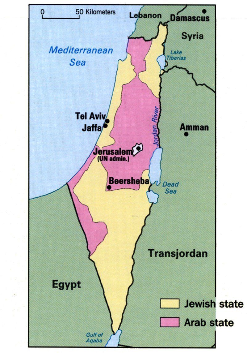
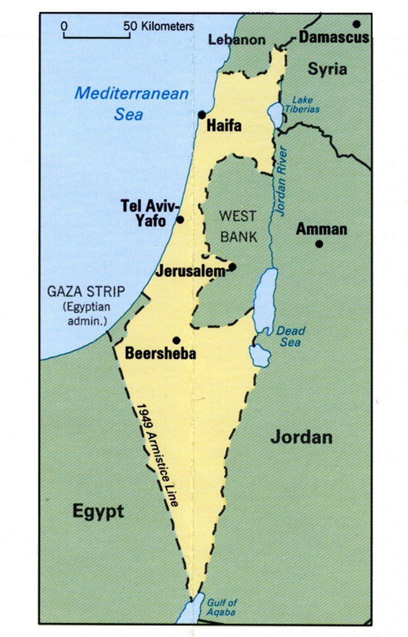
Palestine region articles | |||||||||
|---|---|---|---|---|---|---|---|---|---|
| History |  | ||||||||
|
| Regimes |
| ||||||||